Research Article | | Peer-Reviewed

Assessment of the Water Pollution Level of the N'ZI River (Côte d'Ivoire)

Received: 10 February 2025     Accepted: 25 February 2025     Published: 18 March 2025
Views:       Downloads:
Abstract

Assessment of the state of pollution of the N'ZI river (Côte d’Ivoire), the objective was to evaluate the degree of pollution of the waters of the N'ZI river. To this end, two sampling sessions were conducted in dry and rainy seasons. The descriptions of the physical parameters (Potential hydrogen (pH)), Temperature, Electrical Conductivity, Dissolved Oxygen, and Turbidity) were measured in situ using the multi-parameter HANNA instruments pH/conductivity brand HI 98129. The suspended matter was filtered and some chemical parameters were determined according to French standards agency methods. The chemical parameters were determined by spectrophotometer, titration, and metals were analyzed by Inductively Coupled Plasma (ICP). The results of the analyses are compared with the standard norms of the WHO (World Health Organization) or the water framework guidelines of the EU (European United) and France. Temperature and conductivity show low mineralization of the water, as well as dissolved oxygen and oxygen content, and significant variation in turbidity and suspended solids. The nitrate, nitrite, phosphate, and ammonium levels are low compared to standard values. Chemical Oxygen Demand (COD) and Biochemical oxygen demand over five days (BOD5) show a significant variation linked to anthropic activities. Heavy metals are above the standard. The results of the analysis showed an alteration of the waters of the N'ZI river from north to south, in general. This study concluded the development of a spatiotemporal monitoring system of the river network and the environment in its future functionality.

Published in Journal of Water Resources and Ocean Science (Volume 14, Issue 1)
DOI 10.11648/j.wros.20251401.12
Page(s) 18-34
Creative Commons

This is an Open Access article, distributed under the terms of the Creative Commons Attribution 4.0 International License (http://creativecommons.org/licenses/by/4.0/), which permits unrestricted use, distribution and reproduction in any medium or format, provided the original work is properly cited.

Copyright

Copyright © The Author(s), 2025. Published by Science Publishing Group

Keywords

Pollution, Surface Water, Water Quality, Standard Water Standards, N'ZI River, Côte-d’Ivoire

1. Introduction
Since the first major project of the Bandama Valley Development Authority (BVA) took place from 1969-1980. This area generates a continuous line of research in development because of changes in the area. Water management of these tributaries, mainly N'ZI River creates a real interest on the part of the drinking water distribution company, local populations, region, scientific community, and state.
Indeed, the N'ZI watershed is preferably an area of high agricultural activities. It was the old loop of cocoa and coffee . Cocoa and coffee production fell from the 1980s onwards, due to a decrease in area in cultivated areas and the change in natural areas or the aging of land and plantations. This led to inhabitants of the N'ZI watershed have turned to other cash crops such as irrigated rice, cotton, cashew nuts, sugar cane, and rubber trees. All are dependent on the N'ZI river and about 500 reservoirs in the North region for agro-pastoral use, as well as dams in the central region for irrigated rice production .
Today, the phenomenon of gold panning, according to the Ministry in charge of environment and the Ministry in charge of industry and mines, as well as the mining cadastre of Côte d'Ivoire, indicates that the N'ZI watershed is a booming mining area. All the actions undertaken in the basin from 1960 to today present environmental, biological, and human risks, as well as disturbances of the N'ZI river caused by river water.
Sediment transport increases during rainy periods and settles in the river current. Also, discharges and soil leaching through runoff can lead to the progressive eutrophication of the resource . It is very common and even observable with the naked eye when passing on the N'ZI river, the water remains generally colored (yellow-brown) with the existence of sedimentary deposits. Conventional physicochemical treatments can no longer make drinking water sometimes, given the deposits and the yellow-brown or reddish color that it generally presents. This is a real threat to life, because water quality, can contain a variety of substances that are hazardous to aquatic ecosystems and humans. These substances are of natural origin (bicarbonates, nitrogen, phosphorus, calcium, sodium, iron, aluminum, etc.) or anthropogenic (wastewater, metals, pesticides). It was the concentration of these different elements that determines the quality of water and whether it was suitable for a particular use.
As a result, the preservation of surface water quality is becoming a major issue given the uses of this resource: drinking water production, water recreation, agriculture, industry, electricity generation, and domestic uses. It is also of biological interest for the preservation of aquatic fauna. For a long time, surface waters have become an alternative or main source of drinking water for African countries and particularly Côte d'Ivoire. Ivorian cities are mainly supplied by surface water. for example, the city of Bouaké, Yamoussoukro, Korhogo, Sinfra, and Gagnoa from the Bandama river; Duekoué, Daloa, Sassandra, and Man from Sassandra river; Toulepleu and surrounding localities from the Cavally River; de Dimbokro, Bocanda, M’bahiakro, Katiola from N’ZI river, and Daoukro from Comoé river .
The country’s post-independence population growth has resulted in an increase in the water needs of populations including access to drinking water, agriculture, and industry. However, these water bodies are receptors of pollutants of various origins (domestic or industrial waste and effluents, runoff water from cultivated land, etc.) .
The studies on water resources by reported the existence of many sources of pollution in both groundwater and surface water, and the risk of water pollution due to anthropogenic activities. In addition, the work of highlighted the impact of human activities, declines or changes in hydrological regimes, and water shortages in the localities of N'ZI watershed, therefore a general decrease in stream flow of approximately 52% due to several factors: decrease in rainfall since 1970, increase in evaporation due to increased temperatures, increase in withdrawals (irrigation, consumption, and others), an increasing population between 2010 and 2014 (900000 to 3030381 inhabitants) and deforestation on water resources in the study area. To provide answers this study was initiated to assess the current state of pollution of the water of the river N'ZI. This would be a major guide to securing investment in the area.
2. Materials and Methods
2.1. Presentation of the Study Area and Sampling Points
The N'ZI watershed is a sub-watershed of the Bandama River located between longitudes 3°49' and 5°22' West and latitudes 6°00' and 9°26' North (Figure 1). It covers an area of 3,576.4 km², for example about 10.88% of the area of Côte d'Ivoire, and is 725 km long . The N'ZI River rises in the north, in the Ferkessédougou region, at an altitude of 400 m and flows into the Bandama at Tiassalé. The N'ZI River is the main river system in the study area. The N'ZI flows generally in a North-South direction. The density of the hydrographic network decreases from South to North (0.54 to 0.74 Km/Km²). The main tributary of the N'ZI is the Kan, which receives about 5 km downstream from Dimbokro. There are other important tributaries .
The N'ZI watershed receives approximately 2 mm to 225 mm of monthly precipitation with an average of 88.93 mm per month over the year. The study area generally includes two types of the wet season. Average annual precipitation ranges from 912 mm to 1338 mm with an overall average of 1084 mm. It is covered in the south by forest ecosystems and in the north and center by savannah ecosystems.
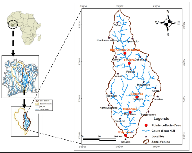
Figure 1. Geographical location and surface water sampling points in watershed N'ZI.
2.2. Human Activities in the Study Area
The main activity of the people living in the N'ZI watershed is agriculture, as highlighted in several studies , hence the old cocoa and coffee loop. After the fall of cash crops in these localities from the 1980s onwards, due to anthropic actions led to the destruction of the vegetation cover resulting in environmental and climatic changes. The local people will move to other sources of income such as irrigated rice, cotton, cashew nuts, sugar cane, and rubber trees, which depend on the N'ZI river. Crops such as yams, groundnuts, and maize, which are the main food crops grown and which use pesticides and fertilizers to increase yields, can be sources of water pollution: fertilizer runoff, pesticide use, and manure all contribute to pollution of waterways and groundwater. The different types of market gardening practiced are produced in the wetlands, whether developed or not, around the tributaries or watercourses of N'ZI as fertilizers and manures . The different crops and their accompanying fertilizers are a source of pollution for the river. The massive use of fertilizers linked to the rapid development of agriculture in the basin is a potential source of water eutrophication. Analysis of the main activities relating to the various uses of the river water shows that these activities have an impact on its quality.
The work of showed that food crops, tomato, rice, salad, and peanut are strongly grown around the containment. Market gardens are mainly produced in the developed wetlands around the water reservoir with fertilizers and manures. The pesticides used were generally cypermethrin, atrazine, and DDT.
According to the work of , this reservoir is the main receptacle for all the city’s wastewater and has now become a real sewage disposal site for domestic, municipal, and agricultural wastewater. These waterways have also become waste and garbage collectors of all kinds. These anthropogenic pressures contribute to the degradation of their quality.
Mining is increasingly becoming a highly developed sector in the N'ZI catchment area, which has registered several research and mining permits in departments. Industrial or fluctuating artisanal mining of several minerals in Côte d'Ivoire is done through open pit mining. This method of exploitation generates major environmental problems such as the destruction of soil, pollution of waterways, drying of groundwater, and destruction of plants . The immediate consequence is an increase in soil erosion and water turbidity, as well as a change in the hydrological regime . Thus, there is an increased suspended matter load in the water, and deposits of all people in the river have many consequences for aquatic and human life.
2.3. Data
Water samples were taken from the bed of the N'ZI River in localities of N’zianouan, Dimbokro, Bocanda, Fêtékro et Katiola-Dabakala (Figure 1) during the short or long rainy or dry season (20 raw water samples were collected). Water samples were taken from 1,000 mL polyethylene vials, previously rinsed with site water. Samples were then stored in a cooler using 4°C dry ice during transport to the laboratory for parameter analysis according to the standard. Samples were taken twice per measurement site. A sample received a drop of concentrated hydrochloric acid for analysis of the main major elements on the one hand. And on the other hand, the other sample of raw water is retained without adding acid to measure the other parameters.
2.4. Materials (Tools)
The materials used for data processing are grouped into:
1) A LOVIBOND multi-parameter type SENSO DIRECT 150 or (HANNA) for in situ measurements;
2) A membrane filter and an oven for TSS analysis;
3) The spectrometer or titration for reading parameters such as nitrate, ammonium, sulfate, and phosphate;
4) An isotope oxitop for BOD5 measurement;
5) An ICP device for the measurement of metals;
6) A JP SELECTA mineralizer for COD measurement.
2.5. Methods
2.5.1. Collection of Raw Water Samples
The water sample collection sites are shown in Figure 1. The five (5) sites were selected based on the sub-basins that make up the study area. The water samples were taken by the manual method, following the protocol drawn up by AFNOR (Association Française de Normalisation) and the Loire-Bretagne Water Agency in 2006 . The water samples were collected, according to the linear judgment method with a suitable container periodically (January-April and June-September). They are taken at a selected point, at a depth of about 30 cm (sample), and at a given time (season). Sampling was conducted at strategic locations (water current, flow direction, water heights). Water samples were taken from 1000 mL capacity polyethylene vials, and rinsed with site water. Samples were then stored in a cooler containing dry ice during transport to the laboratory for analysis.
2.5.2. Physical Pollution Indicators
The physical parameters measured were temperature (T°C), hydrogen potential (pH), electrical conductivity (EC), dissolved oxygen (DO), and turbidity (NTU) were measured in situ using the HANA multi-parameter device directly in N'ZI river. To measure a parameter, the corresponding probe of the instrument is immersed directly into the sample after rinsing with distilled water. The turbidity of the N'ZI River water was measured using a probe turbidimeter. The tube was cleaned with distilled water and wiped with paper towels, before dipping the probe into the raw water. The different values showed on the display of the device. The estimation of suspended solids (SS) in the water of the N'ZI river was done by the Whatman glass fiber membrane filtration method according to AFNOR standard, NFT90- 105 .
2.5.3. Organic Pollution Indicators
The parameters of organic pollution analyzed in this section were: five-day biochemical oxygen demand (BOD5) carried out by the isotope method using oxitop, which is based on measuring the pressure in a closed system (micro-organisms will feed on the oxygen in the environment). The chemical oxygen demand (COD) did by colorimetric titration. The calculation of COD is based on the amount of potassium dichromate reduced. Ammonium (NH4+) is measured by the spectrometer. Nitrite (NO2-) and nitrate (NO3-) were measured by the HACH device and the phosphate was measured by the spectrometer corresponding to the principle of NF T 90-923. Organic matter (OM) is calculated in each sample with the relationship between BOD5, COD, and OM .
2.5.4. Mineral (Chemical) Pollution Indicator
The chemical pollution parameters described here include toxic elements (mercury (Hg), plomb (Pb), cyanuric (Cn), cadmium (Cd), and arsenic (As)). chrome (Cr), nickel (Ni), and undesirable elements (aluminum (Al), copper (Cu), iron (Fe), manganese (Mn), magnesium (Mg), potassium (P), and zinc (Zn). The analysis of these different concentrations is carried out at the Laboratoire des Procédés Industriels, de Synthèse, de l'Environnement et des Energies Nouvelles (LAPISEN) of IN-PHB, Yamoussoukro (Côte-d’Ivoire). The concentrations of major elements were measured by the ICP apparatus. The total concentration is measured when the sample is mineralized by the argon plasma atomic emission spectrometer. The sample is introduced into the plasma through a pump and a nebulizer. The metals in the sample were sprayed into the plasma at a high temperature. They emitted light energy at mutually specific wavelengths .
3. Results and Discussion
3.1. Physical Parameters
3.1.1. Hydrogen Potential (pH)
Figure 2 shows the evolution of pH at the sampling site in dry and wet periods. It varies between 6.5 and 7.7 during the dry period and 7.1 to 7.5 during the wet period. Water samples taken are slightly basic. In terms of pH values, the waters of the river N'ZI cross almost basic terrain. This shows an increased presence of ammonium ions (ammonia) (toxic to fish), but optimal life for other aquatic beings. The pH reaches the minimum standard of 6.5 prescribed by SEQ-Eau or the EU/WHO Framework Directive at the measurement sites, except at Dimbokro during the dry season. These pH variations could be explained by the dilution phenomena through the rainfall of the area, on the pH values of the aquatic environments, and by the influence of the runoff waters generally loaded with various materials. These results highlight that the pH of the N'ZI River is weakly varied from site to site. Therefore, pH could have a significant impact on fauna and flora, if they were less than 5 or greater than 9 and were lethal to fish .
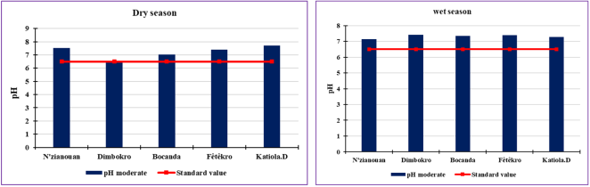
Figure 2. Evolution of the pH of the water of the N'ZI river.
3.1.2. Temperature (T°C)
Figure 3 presents the variation in water temperature in the N'ZI River. Temperature values are above room temperature (24°C) for both seasons. The change in T°C indicates a decline from south to north of 27.7 to 25.5°C during the wet period, while in the dry period, it varies slightly from one measurement point to another between 26.28 and 26.4°C (Figure 3). These small variations in temperature during the two periods could be justified by the ambient air temperature, a strong decrease in the water current and stagnation of the water in the minor bed at the places covered by vegetation which protects it from the solar rays. Surface water temperature is also influenced by stream depth. High temperatures could be harmful to fish, lethal to some species, and favor the growth of various aquatic creatures (bacteria, parasites, mosquitoes, microbial germs).
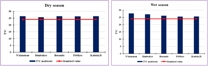
Figure 3. Evolution of the water temperature of the river N'ZI.
3.1.3. Mineralization and Color Parameter
1) Conductivity (C. E)
Figure 4 shows the evolution of water conductivity in the N'ZI River from 40 to 1000 µS/cm. They are generally very low compared to the standard (180 to 2500 µS/cm). The maximum (950 µS/cm) is recorded in Dimbokro and the minimum (76.1 µS/cm) in Katiola-D during the dry period. In contrast, during the wet season, the lowest conductivity of 40.8 µS/cm is recorded at Katiola. D. The highest conductivity of 88.1 µS/cm is recorded in N'zianouan. It meets the minimum standard at the station of Dimbokro and Feckro during the dry season. This reflects excessive mineralization of the river water which could be attributed to wastewater discharges, mainly industrial effluents, or to nearby agricultural practices and also by runoff during rainfall .
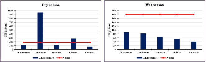
Figure 4. Evolution of water conductivity in the N'ZI river.
2) Color (mg/L Pt/Co)
Figure 5 displays the evolution of watercolor in the N'ZI River. Strong colors are recorded at Katiola-D (226 mg/L Pt/Co) and weak colors at N'zianouan (18 mg/L Pt/Co), in the dry period. In general, there is a small decrease in watercolor concentration during the wet season between 25 and 116 mg/L Pt/Co. The minimum standard is achieved at all sampling sites in both periods. The high or low concentration of colors at one sampling point compared to another can be explained by the decomposition time of the materials in the water of the N'ZI river. Our values evolve in the same order as those found by in the Democratic Republic of Congo ranging from 27.66-153 mg/L Pt/Co and also that of vary from 3.61 -128.67 mg/L Pt/Co in Benin for surface waters.
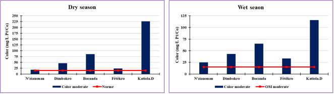
Figure 5. Evolution of the watercolor of the river N'ZI.
3.1.4. Pollution Parameters of Suspended Matter
1) Turbidity (NTU)
Figure 6 provides information on the spatial and temporal evolution of water turbidity in the N'ZI River. Turbidity results ranged from 31.84 to 271.20 NTU at N'zianouan and Katiola respectively. NTU decreases from north to south, in dry periods. However, during the wet period, the NTU varies from 192 to 1166 NTU reciprocally at N'zianouan and Bocanda. NTU in the rainy season is much higher in the dry season. This can be supported by early rains and soil erosion. Note that the NTU is significantly higher than the prescribed standard (1 to 35 NTU). These fluctuations evolve in a similar way to the concentrations of suspended solids.
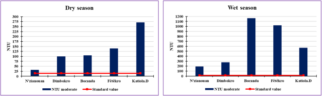
Figure 6. Evolution of the NTU of the N'ZI river water.
2) Suspended solids (TSS)
Figure 7 shows the evolution of TSS, the highest of which is found at Katiola. D and the lowest at N'zianouan during the dry period from 41.91 to 378.13 mg/L respectively, on the other hand, during the wet season the lowest suspended loads at N'zianouan and the highest at Fétékro from 46.52 to 537.14 mg/L are recorded (Figure 7). The variations of the high loads seem to be due to the nature of the land crossed which can vary according to the watercourse, the season and the quantity of the various discharges. This could prevent the passage of light, reduce dissolved oxygen, and promote sludge deposition and backfill of the river limiting aquatic life .
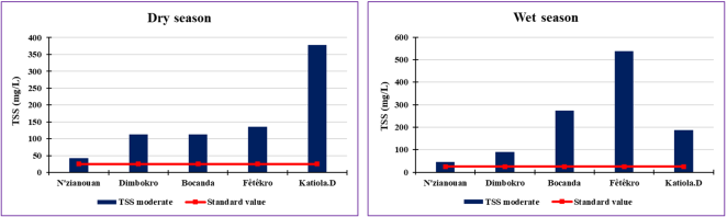
Figure 7. Evolution of TSS in the N'ZI river water.
3.2. Pollution Parameters of Organic and Oxidizable Matter
3.2.1. Five-day Biochemical Oxygen Demand (DBO5)
Figure 8 appears that BOD5 for both periods is generally of poor quality. It ranges from 10 to 100 mg/L O2 during the dry period and from 6 to 8 mg/L O2 during the wet period (above the prescribed standard of 3 to 6 mg/L O2) . This divulges that there is enormous pollution of biodegradable material at the sites over both periods. And also, they were characterized by the phenomenon of eutrophication because of the proximity of agricultural lands as well as polluted urban discharges. The most polluted sites are observed during the dry season, on the other hand, there is a type of decontamination during the wet period that promotes the growth of the quantity of dioxygen necessary for the micro-aerobic water organisms to oxidize suspended matter in the river N'ZI. These results are much lower than those of in the order of 620 to 1063 mg/L in the rivers of Bukavu in the Democratic Republic of Congo. And in Côte d'Ivoire, it varies from 87.7 to 863.7 mgO2/L in Abidjan waters and they are in the same order of magnitude as those from 0 to 150 mgO2/L in Bonoua .
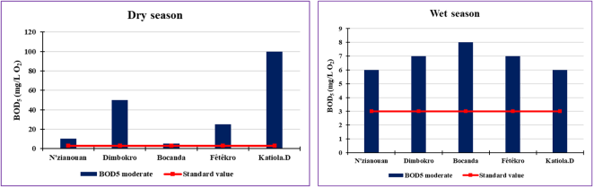
Figure 8. Evolution of BOD5 in the water of the river N'ZI.
3.2.2. Chemical Oxygen Demand (COD)
COD values do not vary significantly between sites. These values range from less than 9.5 mg/L CO2 at Katiola. D to 13.31 mg/L CO2 at Dimbokro, during the wet season. While high COD values are recorded during the dry season ranging from 19.91 to 154 mg/L CO2 in Fétékro and Katiola. D. All sites have values above the pollution limit (Figure 9). These fluctuations are probably linked to anthropic activities that generate effluents rich in nitrogenous compounds, sugars, and organic acids, thus increasing their organic and mineral load in the water of the N'ZI river .
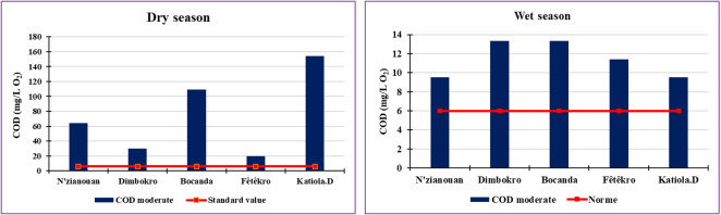
Figure 9. Evolution of COD in the N'ZI river water.
3.2.3. Organic Matter (OM)
OM is highly significant at all sites sampled in both periods. They range from 23.30 to 118 mg/L C and from 7.17 to 9.77 mg/L C respectively (Figure 10).
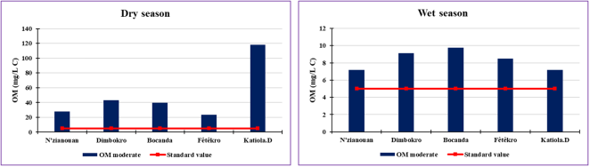
Figure 10. Evolution of OM in the water of the N'ZI river.
The highest values are observed during the dry period this can be justified by the fall of abundant leaves in the water that contributes to the increase in carbon load, already increased during the rainy seasons, and organic fertilizers or soil erosion as presented above, thus contracting a large increase in total organic carbon. This justifies the superiority of OM concentrations compared to the standard prescribed (3 to 5 mg/L C) by the EU Framework Directive or WHO.
3.2.4. COD/BOD5 Ratio
Table 1 summarizes the character of the biodegradation of organic matter present in the different water samples of the N'ZI river. The calculation results show that for all stations the ratio generally points to a ratio of less than 2 during the two easily degradable seasons, except during the dry season at the station of N'zianouan and Bocanda, where MO is hardly biodegradable. This indicates that the pollutant load in these waters is biodegradable. This confirms that these waters are clean for drinking.
Table 1. River N'ZI COD/BOD5 ratio.

COD/BOD5

Dry season (DS)

Wet season (WS)

Appreciation

N'zianouan

6.42

1.58

PS: Hardly biodegradable

PH: better biodegradability

Dimbokro

0.60

1.90

PS and PH: better biodegradability

Bocanda

21.84

1.66

PS: Not readily biodegradable

PH: better biodegradability

Fêtêkro

0.80

1.63

PS and PH: better biodegradability

Katiola. D

1.54

1.58

PS and PH: better biodegradability

Dissolved oxygen (DO)
Figures 11 and 12 show the variation of dissolved oxygen and the saturation rate of dissolved oxygen in the water of the N'ZI river. They range from 3.4 mg/L O2 (Feckro) to 6.2 mg/L O2 (N'zianouan), with oxygen saturation rates of 33% and 59% respectively, during the dry season. There is an increase in wet periods of 4.71 to 7.1 mg/L O2 reciprocally in Bocanda and Dimbokro, with a saturation rate of 50.6 to 61.6%.
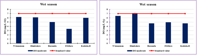
Figure 11. Evolution of DO in N'ZI river water.
3.2.5. Oxygen Saturation (TO2) (%)
Based on these results, all values are below the prescribed standard of 7 to 8 mg/L O2 and 60 to 90 respectively for OD and TO2. This low oxygen growth in the waters of the N'ZI is justified by the increase in temperature, as well as the decomposition of organic matter in the N'ZI river.
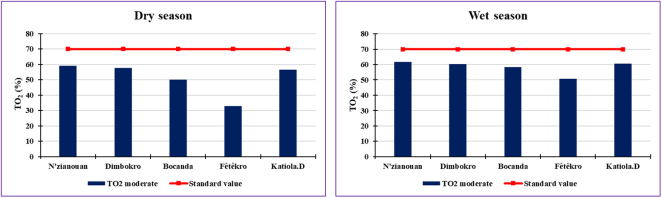
Figure 12. Evolution of TO2 in N'ZI River Water.
3.2.6. Pollution Parameters of Nitrogenous Materials Excluding Nitrates
1) Ammonium (NH4+)
Figure 13 presents the variations in ammonium in the N'ZI river. They vary from 20.03 to 68.39 mg/L respectively in Bocanda and Katiola. D during the dry season. Compared to the rainy season, NH4+ concentrations vary between 0.2 and 0.4 mg/L and are mutually recorded in Katiola. D and Bocanda. All concentrations above 0.05 mg/L are prescribed. These high concentrations could be justified by the high use of the watercourse by animals which are for the most part the cause of excrements that constitute a source of ammonium. In addition to this, there is waste from living organisms, as well as biodegradation from domestic, industrial, and agricultural sources .
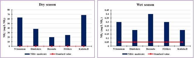
Figure 13. NH4+ evolution in the N'ZI river water.
2) Nitrite (NO2-)
Figure 14 shows the variation of NO2-. Nitrite levels are relatively low during the wet period. Values vary from a minimum of -0.002 mg/L at Dimbokro to a maximum of 0.013 mg/L at Feckro. The nitrate content of the samples in the study area is below 0.05 mg/L according to the prescribed standard. While in dry periods the levels are much higher than the norm. It decreases from north to south. Fluctuations in concentrations can be explained by agricultural practices and also by the decomposition of organic matter, leaching of chemical fertilizers, animals, septic tanks, and sewage discharges which are drained by the river via runoff .
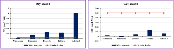
Figure 14. Evolution of NO2- in river water N'ZI.
3.2.7. Nitrate Pollution Parameter (NO3-)
The nitrate results are presented in the graphs in Figure 15. They are almost negative at the level of sites in the wet period. This may reflect the leaching of nitrate content during the rains. On the other hand, they vary between 0.15 and 4.46 mg/L respectively at N'zianouan and Katiola. D, during the dry season. They vary from upstream to downstream (below the minimum standard of 25 mg/L). This cannot be justified by the low use of chemical fertilizers or the environment is rich in animal hope and microorganisms highlighted by as well as the rainfall break in the study area revealed by .
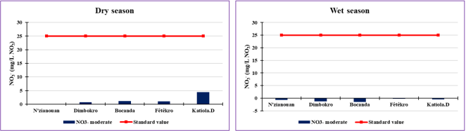
Figure 15. Evolution of NO3- in river water N'ZI.
3.2.8. Phosphorus Pollution Parameters
1) Phosphates (PO43- )
Figure 16 indicates the fluctuation of PO43-. It underlines almost negative values during the wet period while they evolve strongly in Katiola. D from 0.54 to 0.10 mg/L at N'zianouan during the dry period and is above the prescribed standard (0.1 mg/L). This absence in the rainy season could be because phosphate ions are likely to be absorbed by the sediments during significant deoxygenation. Phosphate is naturally present in surface waters in small quantities as a result of its use in agriculture in the form of chemical fertilizers or pesticides .
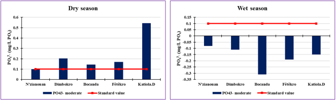
Figure 16. Evolution of PO43- in river water N'ZI.
2) Total Phosphorus (TP)
Figure 17 shows the variation in total phosphorus. During the dry period, it varies from 10.21 to 14.39 mg/L, very significant compared to the wet period of 0.19 to 0.31 mg/L respectively in N'zianouan and Dimbokro. Values above the prescribed standard (0.05 to 0.2 mg/L) at all sites. This can result in the decomposition of organic matter, or the leaching of minerals that have naturally enriched surface waters with phosphorus. In addition, concentrations appear to be increased by agricultural or industrial inputs .
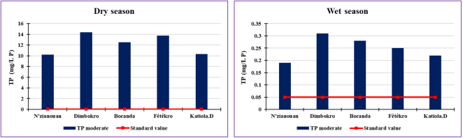
Figure 17. Evolution of TP in river water N'ZI.
3.3. Mineral Micropollutant Parameters in Raw Water
3.3.1. Toxic Mineral Micropollutants
The histograms in Figure 18 display the evolution of the toxic heavy metals measured. The results of elements studied such as Lead (Pb), Mercury (Hg), Cadmium (Cd), Arsenic (As), and Copper (Cu) show concentrations well above the surface water standard at all sampling points . Except for chromium (Cr), nickel (Ni), and boron (B) (Figure 18). Hg shows a very remarkable presence at all measurement sites. This metal is very toxic to life stress concentrations in the order of 2.43 to 1.07 mg/L respectively at N'zianouan and Bocanda. This dominance of Hg in these different sites could be justified by the presence of garbage dumps near the stream. In recent years, there has been a remarkable presence of gold in the study area, which uses certain metals such as mercury (Hg) in gold mining . It should be noted that the Fétékro measurement site shows a very significant variation of metals such as Pb, Hg, As Cu, and Ni of 0.10, 1.37, 1.42, 0.93, and 0.83 mg/L respectively. The significant presence of elements in the river water indicates an advanced state of pollution of the N'ZI river waters. These increased parameters may reflect the current watercolor of the N'ZI River
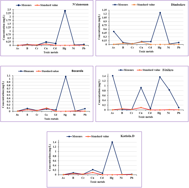
Figure 18. Evolution of toxic metals in river water N'ZI.
3.3.2. Undesirable Mineral Micropollutants
Figure 19 testifies to the results of undesirable mineral micropollutants which constitute the major and dissolved elements. The quantities are very low at all sites compared to the recommended standard for river water . The most important minerals are Iron (Fe), Zinc (Zn), Sodium (Na), and Magnesium (Mg) with quantities of 7.73; 1.63; 7.06, and 0.12 mg/L respectively. The others range from -0.05 to 0.06 mg/L < 0.07 mg/L. The low amounts of essential elements (Fe, Mn, Zn) in the water show high animal and plant life in the N'ZI river water compared to the prescribed drinking standard. This confirms the abundance of organic elements leading to the eutrophication of the river over the years through the abundance of phosphorus. The presence of iron, aluminum, and others in the river underlines the degradation of the surrounding rocks brought into the riverbed during rainfall by runoff. This enrichment in Na element can be the result of the inflow of wastewater into the river at the point of withdrawal. The presence of metals in waters N'ZI is explained by activities of the different zones, for example, the practice of agriculture using fertilizers and pesticides which constitutes a source of pollution. In addition, wastewater is carried back into the stream by runoff during rainfall .
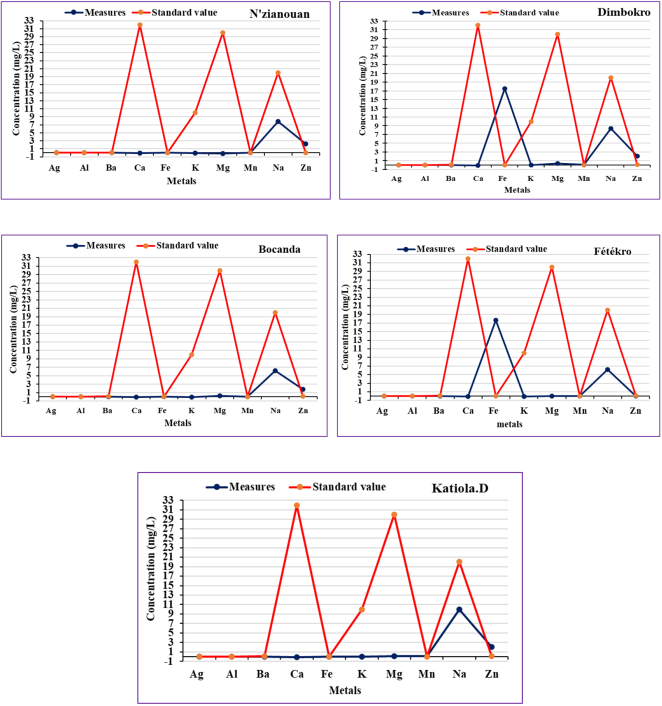
Figure 19. Evolution of undesirable metals in river water N'ZI.
3.4. Discussion
Analysis of the physical parameters of the surface waters of the N'ZI River, temperature, pH, conductivity, color, dissolved oxygen, TSS, turbidity temperature, pH, conductivity, color, dissolved oxygen, TSS, turbidity generally shows a more or less significant temporal spatial variation from one sampling point to another. Most temperatures are above room temperature - about 24°C. The results agree with those found by . This would affect the aquatic community causing oxygen dissolution. As for the pH values obtained, between 6 and 9 indicates basic soil. They evolve in the same direction as those found by on the Ivorian coastline (6.5 to 9). Unlike those found by in the Abidjan-Agboville region, in the mountainous West, and the Adiaké region by , whose results show acidic waters. The mineralization of N'ZI river water is reflected in its electrical conductivity, which ranges from 40 to 1000 µS/cm, the causes of which are related to local activities and various discharges. These results vary in the same order as the results of C. E. in the work of in the Agnéby basin at Agboville. Turbidity and suspended matter show very significant values with strongly fluctuating coefficients of variation (50-95%), thus indicating that the waters of the N'ZI river are highly charged and have a turbid character. These results are similar to those found by in their work on the Sassandra River. These strong temporal variations of the parameters are justified by the rainfall regimes and the various anthropic practices to which the entire basin is subjected. The assessment of the pollution status of the N'ZI river shows very significant pollution. The parameters analyzed showed concentrations exceeding the prescribed standards in general . Organic pollution is more pronounced at all measurement sites. Thus, COD and BOD5 reports indicate that effluents are biodegradable. Organic water pollution also expresses a very strong increase in turbidity and the presence of suspended matter. Our results are in the same order as those found by . The high COD, BOD5, and NH4+ values may be justified by analytical conditions and anthropogenic activities in the study area. These values vary in the same order of size as those found by .
4. Conclusions
The present work has enabled a general assessment of the current state of pollution of the N'ZI river. The average of the analyzed parameters and the calculation of the quality index using the mathematical formula was compared with the standard established by the EU and WHO framework directives. It offered some interesting results. The results of the physicochemical analyses showed that the water of the N'ZI river has a very good to average quality for the different water uses from upstream to downstream. On the other hand, most micro-mineral pollutants indicate poor to very poor quality at all measuring points.
The overall degradation of water quality in the study area is mainly due to micro-organisms, phosphate, and nitrite, micropollutants. It results from the discharge of various materials transported by runoff water during the phenomenon of leaching and agricultural practices. The variability of physical descriptors such as T°C, NTU, pH, and EC reveals disturbances in the water quality of the N'ZI river. The small variation in T°C did not favor normal aquatic life. Turbidity fluctuates widely, related to the environment and activities surrounding the stream. The high turbidity of the river is mainly related to agricultural practices, but could also be related to other types of land use around the river. Large fluctuations in turbidity from one point to another cause significant disturbances in the physical parameters of the river that maintain a turbid water character during the year.
The waters of the N'ZI River have low levels of dissolved salt, in general, this reflects low mineralization of the waters from one site to another. The waters of the N'ZI River are generally basic due to the depletion of the water layers in CO2.
The waters of the river N'ZI present a low risk of pollution of chlorides, phosphates, nitrites, and nitrates. On the other hand, the pollution of water with organic matter (COD and BOD5), of which all water is biodegradable to hardly biodegradable. Heavy metal concentrations indicate low water pollution. In general, there is a wide variation in water quality in some places due to external environmental disturbances. Although the waters of the N'ZI River are unsafe due to human activities. They nevertheless retain their natural qualities and can be used for many purposes such as the production of drinking water. The bacteriological analysis would be a means of assessing water quality over time. This could provide interesting prospects for studies on this river, to assess the degree of global pollution of the river and to assess its capacity to self-purify.
Abbreviations

pH

Potential Hydrogen

ICP

Inductively Coupled Plasma

WHO

World Health Organization

AFNOR

Association Française de Normalisation

COD

Chemical Oxygen Demand

BOD5

Biochemical Oxygen Demand over Five Days

EU

European United

CO2

Carbon Oxygen

C. E

Conductivity

TSS

Suspended Solids

Pt/Co

Platin/Color

Acknowledgments
We are grateful to the Laboratory of Industrial Processes, Synthesis, Environment and New Energies (LAPISEN) of Institut National Polytechnique Félix Houphouët-Boigny, Yamoussoukro, Côte d’Ivoire. We would also like to thank all those who contributed to the improvement of this article. We acknowledge and appreciate the welcome given to us during the data collection by the people living in the different localities.
Author Contributions
Yao Koffi Léon: Conceptualization, Data curation, Formal Analysis, Funding acquisition, Investigation, Methodology, Software, Validation, Visualization, Writing – original draft
Kouakou Koffi Eugène: Formal Analysis, Investigation, Methodology, Project administration, Resources, Supervision, Validation
Kouakou Akissi Bienve Pélagie: Formal Analysis, Resources, Supervision, Validation, Visualization, Writing – review & editing
Yapo N’Zébo Sylvestre: Formal Analysis, Supervision, Validation, Writing – review & editing
Kouassi Amani Michel: Formal Analysis, Supervision, Writing – review & editing
Data Availability Statement
All necessary data are contained in the manuscript.
Conflicts of Interest
The authors declare no conflicts of interest.
References
[1] Yao, K. L., Kouakou, K. E., Kouassi, A. M., Deguy, A. J.-P, & Camara, M. (2023). Analysis of land use change in the N'ZI watershed of Côte d'Ivoire using Landsat satellite images. Earth and Space Science, 10, e2022EA002744.
[2] Bokolrz, A. N. N., Cisse, G., Kone2r5, B., & Dedy, S. F. (2016). Croyances locales et stratégies d’adaptation aux variations climatiques à Korhogo (Côte d'Ivoire). tropicultura, 34(1), 40-46.
[3] Schoumans, O., Chardon, W. J., Bechmann, M., Gascuel-Odoux, C., Hofman, G., Kronvang, B., Litaor, M., Lo Porto, A., Newell Price, P., Rubaek, G., 2011. Mitigation options for reducing nutrient emissions from agriculture. A study amongst European member states of Cost action. Report 2141, Alterra Wageningen, The Netherlands 144 pp.
[4] Gilles Pinay, Chantal Gascuel, Alain Ménesguen, Yves Souchon, Morgane Le Moal, Alix Levain, Florentina Moatar, Alexandrine Pannard, Philippe Souchu., 2018. L’eutrophisation: manifestations, causes, conséquences et prédictibilité. 1-176. Éditions Quae.
[5] Lemoine, J.-P., Hir, P. L., Grasso, F., 2020. Numerical Study of Sediment Transport in the Seine Estuary: Contribution of Dredging, in: Estuaries and Coastal Zones in Times of Global Change. Springer, pp. 241–255.
[6] BNETD, E., Tera, R., 2016. Analyse qualitative des facteurs de déforestation et de dégradation des forêts en Côte d’Ivoire. Programme ONU-REDD, Abidjan. 114p.
[7] BNETD. (2018). Rapport de Elaboration de l'étude d'Avant-Projet Détaillé des travaux de renforcement du système AEP des localités de Grand-Lahou, de Yocoboué et de Guitry, 60p.
[8] ETEIFA Expertises (Juin 2016): projet de Renforcement de l’Alimentation en eau potable en milieu urbain (PREMU): alientation en eau potable de la ville de Béoumi; Etude d’Avant Proejt Détaillé (APD), volume 1 définitif APS, 76 p.
[9] CGES (Cadre de Gestion Environnementale et Sociale). (2017). Programme d'investissement regional de résilience des zones cotière en Afrique de l'Ouest (WACA CÔTE D'IVOIRE), 171p.
[10] Soro, T. D., Kouakou, B. D., Kouassi, E. A., Soro, G., Kouassi, A. M., Kouadio, K. E., & Soro, N. (2013). Hydroclimatologie et dynamique de l’occupation du sol du bassin versant du Haut Bandama à Tortiya (Nord de la Côte d’Ivoire). VertigO, 13(3).
[11] Kouassi, A. M., Mamadou, A., Ahoussi, K. E., Biemi, J., 2013. Simulation de la conductivité électrique des eaux souterraines en relation avec leurs propriétés géologiques: cas de la Côte d’Ivoire. Revue Ivoirienne des Sciences et Technologie 21, 138–166.
[12] Koudou, A., N’dri, B. E., Niamke, K. H., Adjiri, O. A., Sombo, A. P., Niangoran, K. C., 2016. Analyse de la productivité et estimation de la vulnérabilité à la pollution pour l’optimisation de l’implantation des forages dans les aquifères de socle du bassin versant du N’zi (Côte d’Ivoire). Bulletin de l’Institut Scientifique, Rabat, Section Sciences de la Terre 149–164.
[13] Kouassi, J.-L., 2019. Variabilité climatique, dynamique des feux de végétation et perceptions locales dans le bassin versant du N’Zi (Centre de la Côte d’Ivoire) (phdthesis). Institut National Polytechnique Felix Houphoët Boigny - Yamoussoukro. 250p.
[14] Yao, K. L, Y.., Kouakou, K. E, Kouassi, A. M, & Asaph, G. (2022). [Analysis of the risks of rainfall aggressiveness on the soils of the N’ZI watershed (Côte d’Ivoire)]. International Journal of Innovation and Applied Studies, 38(2), 454-469.
[15] Blé, L. O., Kouassi, A. E., Adro, J. E., & Degny, S. (2022). Etat de pollution des eaux de la rivière Kan, après la crise militaro-politique de 2010 en Côte d’Ivoire. International Journal of Biological and Chemical Sciences, 16(2), 878-890.
[16] Koffi, Y. B., Ahoussi, K. E., Kouassi, A. M., & Biemi, J. (2014). Ressources minières, pétrolières et gazières de la Côte d’Ivoire et problématique de la pollution des ressources en eau et des inondations. Geo-Eco-Trop, 38(1), 119-136.
[17] Ahoussi, K. E., Koffi, Y. B., Kouassi, A. M., Soro, G., Soro, N., Biémi, J., 2013. Étude de la variabilité hydroclimatique et de ses conséquences sur les ressources en eau du Sud forestier et agricole de la Côte d’Ivoire: cas de la région d’Abidjan-Agboville. International Journal of Pure & Applied Bioscience 1, 30–50.
[18] Lazare, T. I. A., Fernand, A. S., Kouassi, K., 2018. Impacts des exploitations aurifères industrielles sur le milieu naturel et les populations à Bonikro (côte d’ivoire). Revue de Géographie Tropicale et d’Environnement, n°2, 61-73pp.
[19] Gourari, L., Alaoui-Mhamdi, M., Boushaba, A., & Fedan, B. (2000). Variations des paramètres physico-chimiques des eaux de l'Oued Aggai: significations géo-environnementales et conséquences sur la précipitation des travertins actuels (causse de Sefrou, Moyen-Atlas-Maroc). Journal of African Earth Sciences, 30(2), 283-293.
[20] ONEMA (Office National de l'Eau et des Milieux Aquatiques), 2010. Bilan national des efforts de surveillance de la qualité des cours d'eau. Rapport final, (Office International de l'Eau) Stéphanie LARONDE Katell PETIT. 330p.
[21] Merbouh, C., Namoussi, S., Kabriti, M., Naamane, A., Rihane, A., Iounes, N., 2022. Physico-Chemical Characterization of an Urban Wastewater Effluent and its Impact on the Receiving Environment: Oued Nfifikh (Morocco). Journal of Ecological Engineering 23. (3), 183–193
[22] KAPEPULA Lumami, Lutili MATESO, Amundala SHEKANI, Séverin MUYISA, Théophile NDIKUMANA et Bart VAN DER, 2015. Evaluation de la charge polluante des rivières des eaux usées ménagères et pluviales dans la ville de Bukavu, République Démocratique du Congo. Afrique Science 11(2). 195-204.
[23] Diagne, I., Ndiaye, M., Ndiaye, B., Dione, C. T., Cisse, D., Hane, M., Diop, A., 2017. Répartition des paramètres physico-chimiques et métalliques des eaux usées de Hann (Dakar) avec le milieu marin. International journal of biological and chemical sciences 11, 3100–3109.
[24] Mejraoua, Z., Zine, N.-E., 2017. Caractérisation physico-chimique du Lixiviat de la décharge sauvage de Meknès. Euro Sci J 13, 154–166.
[25] Widjdane, S., Abir, Z., 2022. La Qualité Physico-chimique de l’eau Potable de la région de Guelma. Rapports de master de l'Université 8 mai 1945 Guelma, 79p.
[26] WANGA B. M., MUSIBONO D. E., MPIANA P. T., MAFUANA L. KIZA N. J. & DIANA (2015). Evaluation de la qualité physico-chimique des eaux de la rivière Kalamu de Boma. Congo Sciences, 3(1, March 2015): 56- 57 (8 pages).
[27] Azokpota, E., Youssao Abdou Karim, A., Avocefohoun, S. A., Alassane, A. K., Adandedjan, C., & Mama, D. (2022). Physico-Chemical Characterization of Surface Waters, Traditional Wells and Cisterns Waters Consumed in the Town Halls of Agbangnizoun and Za-kpota In South Bénin. dc. publisher: EPAC/UAC.
[28] Jean-Eudes, O. K., Avahounlin, R. F., Kélomé, C. N., Pierre, O., Adéké, A. M. H., & Vissin, E. W. (2022). Evaluation of the Physico-Chemical Quality and Potability of Groundwater Consumption in Department of Collines at Benin. Journal of Geoscience and Environment Protection, 10(1), 29-48.
[29] Kouamé, H. K., Aké, M. D. F., Assohoun, N. M. C., Djè, M. K., Djéni, N., 2020. Dynamics and species diversity of lactic acid bacteria involved in the spontaneous fermentation of various palm tree saps during palm wine tapping in Côte d’Ivoire. World Journal of Microbiology and Biotechnology 36, 1–12.
[30] WHO (World Health Organization). (2017). Guidelines for drinking-water quality: fourth edition incorporating the first addendum. 631p.
[31] Gnagne, Y. A., Yapo, B. O., Meite, L., Kouame, V. K., Gadji, A. A., Mambo, V., Houenou, P., 2015. Caractérisation physico-chimique et bactériologique des eaux usées brutes du réseau d’égout de la ville d’Abidjan. International Journal of Biological and Chemical Sciences 9, 1082–1093.
[32] Tohouri, P., ADJA, M. G., Gabriel Etienne, A. K. E., & SORO, G. (2016). Hydrochimie des eaux de surface en saison pluvieuse de la région de Bonoua, Sud-Est de la Côte-d’Ivoire. Afrique SCIENCE, 12(6), 151-167.
[33] Chery, L., Cattan, A., 2003. ADES: la banque de données nationale sur les eaux souterraines. La houille blanche 115–119.
[34] Kouakou, L. P. M. S., Kouyate, A., Sanou, A., Tigori, M. A., Meite, N., Bohoussou, K. J. P., & Dibi, B. (2022). Evaluation of the Physico-chemical Quality of Drinking Water in the City of Daloa (Mid-West of Côte d'Ivoire)-Effects on Human Health. Journal of Health and Environmental Research, 8(3), 186-196.
[35] Odjohou, E., Amani, M., Soro, G., & Monde, S. (2020). Caractérisation physico-chimique des eaux d’un système lacustre du cordon littoral ivoirien: cas du lac Labion. International Journal of Biological and Chemical Sciences, 14(5), 1878-1892.
[36] Eblin S. G., Sombo A. P., Soro G, Aka N., Kambiré O. & Soro N., 2014. Hydrochimie des eaux de surface de la région d'Adiaké (sud-est côtier de la Côte d'Ivoire). Journal of Applied Biosciences 75: 6259 – 6271.
[37] KOUAKOU, A. B. P., KAMAGATE, B., & LAWIN, A. E. (2018). Spatial and temporal variation of traces elements in surface water in the Agneby watershed (Côte d’Ivoire, West Africa). Environmental and Water Sciences, public Health and Territorial Intelligence Journal, 2(3), 73-86.
[38] Gboko, Y. D. A., Natchia, A. K. A., Keumean, K. N., & Soro, N. (2022). Suivi de la qualité physico-chimique des eaux du Sassandra à la station hydrométrique de Gaoulou, Sud-ouest de la Côte d’Ivoire. Afrique SCIENCE, 21(3), 127-141.
[39] MEDD- Agences de l'eau., 2003. Système d’évaluation de la qualité de l’eau des cours d’eau (SEQ-Eau), version 2-étude Inter-Agences N° 52 réalisée par le Ministère de l’Ecologie et du Développement Durable (MEDD)-les Agences de l’Eau (AE). 106p.
Cite This Article
  • APA Style

    Léon, Y. K., Eugène, K. K., Pélagie, K. A. B., Sylvestre, Y. N., Michel, K. A. (2025). Assessment of the Water Pollution Level of the N'ZI River (Côte d'Ivoire). Journal of Water Resources and Ocean Science, 14(1), 18-34. https://doi.org/10.11648/j.wros.20251401.12

    Copy | Download

    ACS Style

    Léon, Y. K.; Eugène, K. K.; Pélagie, K. A. B.; Sylvestre, Y. N.; Michel, K. A. Assessment of the Water Pollution Level of the N'ZI River (Côte d'Ivoire). J. Water Resour. Ocean Sci. 2025, 14(1), 18-34. doi: 10.11648/j.wros.20251401.12

    Copy | Download

    AMA Style

    Léon YK, Eugène KK, Pélagie KAB, Sylvestre YN, Michel KA. Assessment of the Water Pollution Level of the N'ZI River (Côte d'Ivoire). J Water Resour Ocean Sci. 2025;14(1):18-34. doi: 10.11648/j.wros.20251401.12

    Copy | Download

  • @article{10.11648/j.wros.20251401.12,
      author = {Yao Koffi Léon and Kouakou Koffi Eugène and Kouakou Akissi Bienve Pélagie and Yapo N’Zébo Sylvestre and Kouassi Amani Michel},
      title = {Assessment of the Water Pollution Level of the N'ZI River (Côte d'Ivoire)},
      journal = {Journal of Water Resources and Ocean Science},
      volume = {14},
      number = {1},
      pages = {18-34},
      doi = {10.11648/j.wros.20251401.12},
      url = {https://doi.org/10.11648/j.wros.20251401.12},
      eprint = {https://article.sciencepublishinggroup.com/pdf/10.11648.j.wros.20251401.12},
      abstract = {Assessment of the state of pollution of the N'ZI river (Côte d’Ivoire), the objective was to evaluate the degree of pollution of the waters of the N'ZI river. To this end, two sampling sessions were conducted in dry and rainy seasons. The descriptions of the physical parameters (Potential hydrogen (pH)), Temperature, Electrical Conductivity, Dissolved Oxygen, and Turbidity) were measured in situ using the multi-parameter HANNA instruments pH/conductivity brand HI 98129. The suspended matter was filtered and some chemical parameters were determined according to French standards agency methods. The chemical parameters were determined by spectrophotometer, titration, and metals were analyzed by Inductively Coupled Plasma (ICP). The results of the analyses are compared with the standard norms of the WHO (World Health Organization) or the water framework guidelines of the EU (European United) and France. Temperature and conductivity show low mineralization of the water, as well as dissolved oxygen and oxygen content, and significant variation in turbidity and suspended solids. The nitrate, nitrite, phosphate, and ammonium levels are low compared to standard values. Chemical Oxygen Demand (COD) and Biochemical oxygen demand over five days (BOD5) show a significant variation linked to anthropic activities. Heavy metals are above the standard. The results of the analysis showed an alteration of the waters of the N'ZI river from north to south, in general. This study concluded the development of a spatiotemporal monitoring system of the river network and the environment in its future functionality.},
     year = {2025}
    }
    

    Copy | Download

  • TY  - JOUR
    T1  - Assessment of the Water Pollution Level of the N'ZI River (Côte d'Ivoire)
    AU  - Yao Koffi Léon
    AU  - Kouakou Koffi Eugène
    AU  - Kouakou Akissi Bienve Pélagie
    AU  - Yapo N’Zébo Sylvestre
    AU  - Kouassi Amani Michel
    Y1  - 2025/03/18
    PY  - 2025
    N1  - https://doi.org/10.11648/j.wros.20251401.12
    DO  - 10.11648/j.wros.20251401.12
    T2  - Journal of Water Resources and Ocean Science
    JF  - Journal of Water Resources and Ocean Science
    JO  - Journal of Water Resources and Ocean Science
    SP  - 18
    EP  - 34
    PB  - Science Publishing Group
    SN  - 2328-7993
    UR  - https://doi.org/10.11648/j.wros.20251401.12
    AB  - Assessment of the state of pollution of the N'ZI river (Côte d’Ivoire), the objective was to evaluate the degree of pollution of the waters of the N'ZI river. To this end, two sampling sessions were conducted in dry and rainy seasons. The descriptions of the physical parameters (Potential hydrogen (pH)), Temperature, Electrical Conductivity, Dissolved Oxygen, and Turbidity) were measured in situ using the multi-parameter HANNA instruments pH/conductivity brand HI 98129. The suspended matter was filtered and some chemical parameters were determined according to French standards agency methods. The chemical parameters were determined by spectrophotometer, titration, and metals were analyzed by Inductively Coupled Plasma (ICP). The results of the analyses are compared with the standard norms of the WHO (World Health Organization) or the water framework guidelines of the EU (European United) and France. Temperature and conductivity show low mineralization of the water, as well as dissolved oxygen and oxygen content, and significant variation in turbidity and suspended solids. The nitrate, nitrite, phosphate, and ammonium levels are low compared to standard values. Chemical Oxygen Demand (COD) and Biochemical oxygen demand over five days (BOD5) show a significant variation linked to anthropic activities. Heavy metals are above the standard. The results of the analysis showed an alteration of the waters of the N'ZI river from north to south, in general. This study concluded the development of a spatiotemporal monitoring system of the river network and the environment in its future functionality.
    VL  - 14
    IS  - 1
    ER  - 

    Copy | Download

Author Information
  • Institut National Polytechnique Felix Houphouët-Boigny (INP-HB), Ecole Doctorale Polytechnique, Yamoussoukro, Côte d’Ivoire; Department of Land and Mineral Sciences, Institute National Polytechnique Felix Houphouët-Boigny, Yamoussoukro, Côte d’Ivoire; Laboratory of Civil Engineering, Geosciences and Geographic Sciences, Yamoussoukro, Côte d’Ivoire

  • Institut National Polytechnique Felix Houphouët-Boigny (INP-HB), Ecole Doctorale Polytechnique, Yamoussoukro, Côte d’Ivoire; Department of Land and Mineral Sciences, Institute National Polytechnique Felix Houphouët-Boigny, Yamoussoukro, Côte d’Ivoire; Laboratory of Civil Engineering, Geosciences and Geographic Sciences, Yamoussoukro, Côte d’Ivoire

  • Institute for Research on New Energies, Université Nangui Abrogoua, Abidjan, Côte d’Ivoire

  • Institut National Polytechnique Felix Houphouët-Boigny (INP-HB), Ecole Doctorale Polytechnique, Yamoussoukro, Côte d’Ivoire; Laboratory of Industrial Processes, Synthesis, Environment and New Energies, Institute National Polytechnique Félix Houphouët-Boigny, Yamoussoukro, Côte d’Ivoire

  • Institut National Polytechnique Felix Houphouët-Boigny (INP-HB), Ecole Doctorale Polytechnique, Yamoussoukro, Côte d’Ivoire; Department of Land and Mineral Sciences, Institute National Polytechnique Felix Houphouët-Boigny, Yamoussoukro, Côte d’Ivoire; Laboratory of Civil Engineering, Geosciences and Geographic Sciences, Yamoussoukro, Côte d’Ivoire