
With rapid urbanization and the continuing process of urban–rural integration, traditional villages in the Lingnan region are increasingly confronted with fragmented public spaces, declining spatial efficiency, and an imbalance between the daily needs of residents and the experiential demands of tourists. Taking Xiaozhou Village, a representative Lingnan water-town village in Guangzhou, as a case study, this paper applies social network analysis to examine the relationships between public spaces and public activities, as well as the differences in spatial use among different activity groups. Based on field investigation, questionnaire data, interviews, and spatial observation, three types of networks are constructed: the public space network, the resident activity network, and the tourist activity network. Through the comparison of network structure, node selection, route preference, and spatial use characteristics, the study reveals that the planned public space system and actual public activity patterns are not fully matched. The findings indicate that residents tend to rely more on daily-life, religious, and service-oriented spaces, while tourists show stronger dependence on accessible routes and sightseeing-related nodes. In response to the problems of weak connectivity, insufficient integration, and uneven spatial vitality, this paper proposes optimization strategies from the perspectives of network association, spatial integration, and continuity of experience. The study aims to support the shared use of public spaces by residents and tourists, and to provide theoretical and methodological references for the renewal and cultural preservation of Lingnan water-town villages.
| Published in | Science Research (Volume 14, Issue 4) |
| DOI | 10.11648/j.sr.20261404.14 |
| Page(s) | 153-160 |
| Creative Commons |
This is an Open Access article, distributed under the terms of the Creative Commons Attribution 4.0 International License (http://creativecommons.org/licenses/by/4.0/), which permits unrestricted use, distribution and reproduction in any medium or format, provided the original work is properly cited. |
| Copyright |
Copyright © The Author(s), 2026. Published by Science Publishing Group |
Public Space, Public Activity, Social Network Analysis, Lingnan Village, Xiaozhou Village
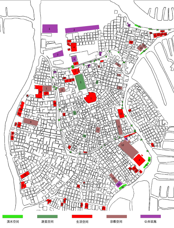
小洲村公共空间类型 | ||
|---|---|---|
空间类型 | 节点内容 | 分布特点 |
宗教空间 | 宗祠、公祠、庙宇 | 多依托传统街巷和水系分布,经街巷网络向周边延伸。 |
游览空间 | 小洲人民礼堂、新滘公社小洲大队门楼、东道大街2号民居、蚝壳屋 | 节点分布松散。 |
生活空间 | 商店、餐饮店、沿街村民聚集的空地、集市、简氏宗祠前广场、公园 | 小型化,分散化。 |
滨水空间 | 桥、沿河涌的石椅、钓鱼空间 | 沿主河涌及支流分布,承担休闲与景观功能。 |
公共设施 | 停车场、公共厕所、社区服务站 | 分布不均,村口区域设施集中,边缘区域设施分布稀疏。 |
公共空间与公共活动网络模型“点 — 线” 语义 | ||
|---|---|---|
网络模型类型 | 点的内涵 | 线的内涵 |
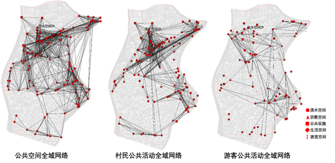
公共空间网络 | 网络中的公共空间节点 | 当路径距离不超过120米且不经过其他空间节点时,两个节点之间通过线段连接。 |
村民/游客公共活动网络 | 网络中的村民/游客集聚点 | 村民/游客≤120 米的直接路径,节点的权重通过使用频率进行量化。 |
特性 | 指标 | 表征 | 内涵 |
|---|---|---|---|
关联性 | 密度 | 网络各节点之间连接的紧密程度 | 反映节点间联系强度。 |
平均相对节点度 | 节点直接连接数量的相对水平 | 反映节点平均直接联系程度。 | |
整合性 | 中心势 | 网络向心性程度 | 反映核心节点对整体网络的主导作用。 |
平均相对中间中心度 | 节点中介作用 | 反映节点作为联系中介的重要性。 | |
连通性 | 聚类系数 | 网络局部紧密程度 | 反映邻近节点间的聚集关系。 |
平均路径长度 | 节点间平均距离 | 反映节点间联系通达效率。 | |
小世界商值 | 网络趋向小世界结构程度 | 反映网络局部聚集与整体连通特征。 |
公共空间与公共活动全域网络特征 | |||||||
|---|---|---|---|---|---|---|---|
关联性 | 整合性 | 连通性 | |||||
密度 | 平均相对节点度 | 中心势 | 平均相对中间中心度 | 聚类系数 | 平均路径长度 | 小世界商值 | |
公共空间网络 | 0.12 | 0.47 | 0.15 | 0.16 | 0.49 | 2.84 | 2.72 |
村民公共活动网络 | 0.09 | 0.10 | 0.07 | 0.07 | 0.80 | 3.47 | 2.43 |
游客公共活动网络 | 0.06 | 0.11 | 0.04 | 0.06 | 1.51 | 4.91 | 4.20 |
|
|
|
|
|
|
| |
| |||||||
生活空间 | 滨水空间 | 游览空间 | 公共设施 | 宗教空间 | ||||||
|---|---|---|---|---|---|---|---|---|---|---|
关联性 | 整合性 | 关联性 | 整合性 | 关联性 | 整合性 | 关联性 | 整合性 | 关联性 | 整合性 | |
平均相对节点度 | 平均相对中间中心度 | 平均相对节点度 | 平均相对中间中心度 | 平均相对节点度 | 平均相对中间中心度 | 平均相对节点度 | 平均相对中间中心度 | 平均相对节点度 | 平均相对中间中心度 | |
公共空间网络 | 0.38 | 0.14 | 0.40 | 0.15 | 0.53 | 0.49 | 0.58 | 0.27 | 0.18 | 0.19 |
村民公共活动网络 | 0.15 | 0.13 | 0.21 | 0.03 | 0.25 | 0 | 0.58 | 0.53 | 0.51 | 0.32 |
游客公共活动网络 | 0.08 | 0.04 | 0.16 | 0.08 | 0.30 | 0.25 | 0.43 | 0.20 | 0.35 | 0.19 |
|
|
|
|
|
|
|
|
|
| |
| ||||||||||
| [1] | 颜嘉慧, 张卫. 基于社会网络分析的文旅型城镇公共空间适应性研究——以衡阳南岳主城区为例 [J]. 建筑与文化, 2025, (08): 178-180. |
| [2] | 小洲村史编纂委员会. 小洲村史 [M]. 广州: 广州出版社, 2005. |
| [3] | 卓柳盈. 广州市小洲村建筑与景观风貌的整治研究 [D]. 华南理工大学, 2011. |
| [4] | [德] 哈贝马斯. 公共领域的结构转型 [M]. 曹卫东, 王晓珏, 刘北城, 宋伟杰, 译. 上海: 学林出版社, 1999. |
| [5] | [美] 雅各布斯. 美国大城市的死与生 [M]. 金衡山, 译. 南京: 译林出版社, 2020. |
| [6] | 何正强. 社会网络视角下改造型社区公共空间有效性评价研究 [D]. 华南理工大学, 2014. |
| [7] | 邹晴晴, 王勇, 李广斌. 基于SNA的新型集中社区公共空间网络结构优化 [J]. 地理科学进展, 2016, 35(07): 829-838. |
| [8] | 丁金华, 周莉. 基于社会网络模型的旅游型乡村公共空间微更新研究——以苏州明月湾村为例 [J]. 现代城市研究, 2021(12): 48-55. |
| [9] | Radcliffe-Brown A R. On Social Structure [J]. Journal of the Royal Anthropological Institute of Great Britain and Ireland, 1940, 70(1): 1-12. |
| [10] | 刘军. 社会网络分析导论 [M]. 北京: 社会科学文献出版社, 2004: 4-5. |
| [11] | 石亚灵. 重庆历史地区的社会网络保护更新研究 [D]. 重庆大学, 2015. |
| [12] | 刘蔚丹. 基于社会网络分析法的重庆市主城区公园绿地可达性研究 [D]. 重庆大学, 2015. |
| [13] | 黄瓴, 瞿欣. 山地城市老旧社区公共空间老年人社交活动特征与可持续更新思路: 基于社会网络分析 [J]. 上海城市规划, 2024, (01): 32-40. |
| [14] | 徐丹华, 龚敏, 张子琪. 空间与行为网络匹配下的乡村公共空间优化策略 [J]. 建筑学报, 2022, (S1): 86-90. |
| [15] | [T/UPSC 0013-2023 街道设计指南] [S]. 中国城市规划学会, 2023. |
APA Style
Shuozhen, W. (2026). A Social Network Analysis of Public Space Activities in Lingnan Villages: The Case of Xiaozhou Village. Science Research, 14(4), 153-160. https://doi.org/10.11648/j.sr.20261404.14
ACS Style
Shuozhen, W. A Social Network Analysis of Public Space Activities in Lingnan Villages: The Case of Xiaozhou Village. Sci. Res. 2026, 14(4), 153-160. doi: 10.11648/j.sr.20261404.14
@article{10.11648/j.sr.20261404.14,
  author = {Wu Shuozhen},
  title = {A Social Network Analysis of Public Space Activities in Lingnan Villages: The Case of Xiaozhou Village},
  journal = {Science Research},
  volume = {14},
  number = {4},
  pages = {153-160},
  doi = {10.11648/j.sr.20261404.14},
  url = {https://doi.org/10.11648/j.sr.20261404.14},
  eprint = {https://article.sciencepublishinggroup.com/pdf/10.11648.j.sr.20261404.14},
  abstract = {With rapid urbanization and the continuing process of urban–rural integration, traditional villages in the Lingnan region are increasingly confronted with fragmented public spaces, declining spatial efficiency, and an imbalance between the daily needs of residents and the experiential demands of tourists. Taking Xiaozhou Village, a representative Lingnan water-town village in Guangzhou, as a case study, this paper applies social network analysis to examine the relationships between public spaces and public activities, as well as the differences in spatial use among different activity groups. Based on field investigation, questionnaire data, interviews, and spatial observation, three types of networks are constructed: the public space network, the resident activity network, and the tourist activity network. Through the comparison of network structure, node selection, route preference, and spatial use characteristics, the study reveals that the planned public space system and actual public activity patterns are not fully matched. The findings indicate that residents tend to rely more on daily-life, religious, and service-oriented spaces, while tourists show stronger dependence on accessible routes and sightseeing-related nodes. In response to the problems of weak connectivity, insufficient integration, and uneven spatial vitality, this paper proposes optimization strategies from the perspectives of network association, spatial integration, and continuity of experience. The study aims to support the shared use of public spaces by residents and tourists, and to provide theoretical and methodological references for the renewal and cultural preservation of Lingnan water-town villages.},
 year = {2026}
}
TY  - JOUR
T1  - A Social Network Analysis of Public Space Activities in Lingnan Villages: The Case of Xiaozhou Village
AU  - Wu Shuozhen
Y1  - 2026/08/11
PY  - 2026
N1  - https://doi.org/10.11648/j.sr.20261404.14
DO  - 10.11648/j.sr.20261404.14
T2  - Science Research
JF  - Science Research
JO  - Science Research
SP  - 153
EP  - 160
PB  - Science Publishing Group
SN  - 2329-0927
UR  - https://doi.org/10.11648/j.sr.20261404.14
AB  - With rapid urbanization and the continuing process of urban–rural integration, traditional villages in the Lingnan region are increasingly confronted with fragmented public spaces, declining spatial efficiency, and an imbalance between the daily needs of residents and the experiential demands of tourists. Taking Xiaozhou Village, a representative Lingnan water-town village in Guangzhou, as a case study, this paper applies social network analysis to examine the relationships between public spaces and public activities, as well as the differences in spatial use among different activity groups. Based on field investigation, questionnaire data, interviews, and spatial observation, three types of networks are constructed: the public space network, the resident activity network, and the tourist activity network. Through the comparison of network structure, node selection, route preference, and spatial use characteristics, the study reveals that the planned public space system and actual public activity patterns are not fully matched. The findings indicate that residents tend to rely more on daily-life, religious, and service-oriented spaces, while tourists show stronger dependence on accessible routes and sightseeing-related nodes. In response to the problems of weak connectivity, insufficient integration, and uneven spatial vitality, this paper proposes optimization strategies from the perspectives of network association, spatial integration, and continuity of experience. The study aims to support the shared use of public spaces by residents and tourists, and to provide theoretical and methodological references for the renewal and cultural preservation of Lingnan water-town villages.
VL  - 14
IS  - 4
ER  -
School of Architecture, South China University of Technology, Guangzhou, China

Information



 Share This Article
 Twitter
 Linked In
 Facebook


 Copy
Copy Download