Abstract
Gidole Town and its surrounding areas have experienced repeated landslide events that have damaged roads, farmland, and settlements, yet detailed engineering geological investigations and quantitative hazard assessments remain limited. This study investigates the engineering geological factors controlling slope instability and develops a landslide hazard zonation map using the Slope Stability Susceptibility Evaluation Parameter (SSEP) method. The research integrates detailed geological and geomorphological mapping, structural discontinuity measurements, landslide inventory mapping, laboratory testing of representative soil samples, and Geographic Information System (GIS)-based spatial analysis. The results show that highly weathered basalt, unconsolidated colluvial deposits, steep slopes, groundwater seepage, and intense seasonal rainfall are the primary controls on landslide occurrence in the study area. The hazard zonation model classified 67.7% of the area as high hazard, 29.0% as moderate hazard, and 3.4% as low hazard. Model validation using the mapped landslide inventory indicated that approximately 74% of documented landslides fall within the predicted high-hazard zones, demonstrating the robustness and reliability of the SSEP approach. The resulting hazard map provides a scientific basis for land-use planning, infrastructure development, slope stabilization, and disaster risk reduction in southern Ethiopia. The findings further demonstrate that the SSEP method is an effective and practical tool for landslide hazard assessment in data-constrained mountainous regions.
|
Published in
|
iResearch (Volume 1, Issue 2)
|
|
DOI
|
10.11648/j.ir.20260102.12
|
|
Page(s)
|
76-92 |
|
Creative Commons
|

This is an Open Access article, distributed under the terms of the Creative Commons Attribution 4.0 International License (http://creativecommons.org/licenses/by/4.0/), which permits unrestricted use, distribution and reproduction in any medium or format, provided the original work is properly cited.
|
|
Copyright
|
Copyright © The Author(s), 2026. Published by Science Publishing Group
|
Keywords
Engineering Geology, Landslide Susceptibility, Hazard Zonation, SSEP, GIS, Ethiopia
1. Introduction
Landslides are among the most destructive natural hazards affecting mountainous landscapes worldwide. They involve the downslope movement of rock, soil, or debris under the influence of gravity and are commonly triggered by a combination of geological, geomorphological, hydrological, climatic, and anthropogenic factors. These processes cause substantial loss of life, damage to infrastructure, disruption of transportation networks, degradation of agricultural land, and significant economic losses
| [17] | Raghuvanshi, T. K., Ibrahim, J., & Ayalew, D. (2014). Slope stability susceptibility evaluation parameter (SSEP) rating scheme—An approach for landslide hazard zonation. Journal of African Earth Sciences, 99, 595–612. |
[17]
. The increasing frequency of extreme rainfall events associated with climate change, together with rapid urbanization and infrastructure development on unstable slopes, has further increased landslide risk globally
| [1] | Ayalew .L(1999) .The effect of seasonal rainfall on landslides in the highlands of Ethiopia Bull Eng Geol Env (1999) 58: 9–19. |
[1]
. Consequently, landslide hazard assessment has become an essential component of sustainable land-use planning and disaster risk reduction.
Ethiopia is particularly vulnerable to landslides because of its rugged topography, highly weathered volcanic rocks, active tectonic setting, and pronounced seasonal rainfall
| [2] | Alemayehu Regassa, K., Van Daele, P., De Paepe, M., Dumon, J., Deckers, J., Asrat, A., & Van Ranst, E. (2014). Characterizing weathering intensity and trends of geological materials in the Gilgel Gibe catchment, southwestern Ethiopia. Journal of of African earth sciences, 99,568-580.
http://doi.org/10.1016/j.jafrearsci.2014.05.01 |
| [4] | Bekele, A., Dramis, F., Fubelli, G., Umer, M., & Asrat, A. (2009). Landslides in the Ethiopian highlands and the Rift margins. Journal of African Earth Sciences, 56, 131–138. |
| [14] | Kifle, W. (2013). Review of the occurrences and influencing factors of landslides in the highlands of Ethiopia: With implications for infrastructural development.Momona Ethiopian Journal of Earth Sciences(MESJS), 5(1),3-31.doi.or.. |
[2, 4, 14]
. Landslides frequently occur within the Ethiopian Highlands and along the escarpments of the Main Ethiopian Rift, where steep terrain and weak geological materials create favorable conditions for slope failure
| [5] | Berhanu, T., Umar, M., & Korme, T. (2001). Natural hazard assessment using GIS and remote sensing methods with particular reference to landslides in the Wondogenet area, Ethiopia. Physics and Chemistry of the Earth, Part C: Solar, Terrestrial & Planetary Science, 26, 665–675.
https://doi.org/10.1016/S1464-1917(01)00065-4 |
| [6] | Bonini, M., Corti, G., Innocenti, F., Manetti, P., Mazzarini, F., Abebe, T., & Pecskay, Z. (2005). Evolution of the Main Ethiopian Rift in the frame of Afar and Kenya rifts propagation. Tectonics, 24, TC1001. |
| [16] | Neaupane, K. M., & Piantanakulchai, M. (2006). Analytic network process model for landslide hazard zonation. Engineering Geology, 85, 281–294.
http://doi.org10.1016/j.enggeo.2006.02.003 |
[5, 6, 16]
. These events have repeatedly damaged highways, cultivated land, settlements, and public infrastructure, emphasizing the need for comprehensive engineering geological investigations and hazard assessment to support sustainable development.
The Gidole area, situated along the western escarpment of the southern Ethiopian Rift System, represents one of the most landslide-prone regions of southern Ethiopia. The area is characterized by steep topography, deeply weathered basaltic rocks, pyroclastic deposits, unconsolidated colluvial materials, active faulting, and intense seasonal rainfall. These geological and environmental conditions have contributed to recurrent slope failures affecting transportation corridors, agricultural land, and local communities. Despite the significant socioeconomic implications of these landslides, detailed engineering geological investigations and scientifically based hazard zonation studies remain scarce
| [11] | Henok, W. (2008). Landslide hazard zonation mapping in Blue Nile Gorges [Unpublished master's thesis]. Addis Ababa University, Addis Ababa, Ethiopia. |
| [12] | Ibrahim, J. (2011). Landslide assessment and hazard zonation in Mersa and Wurgessa area, North Wollo, Ethiopia. Addis Ababa University, Addis Ababa, Ethiopia. |
[11, 12]
.
Several methods have been developed for landslide susceptibility assessment, including heuristic, statistical, deterministic, and machine-learning approaches
| [8] | Fall, M., Azzam, R., & Noubactep, C. (2006). A multi-method approach to study the stability of natural slopes and landslide susceptibility mapping. Engineering Geology, 82(4) 241–263. |
[8]
. Among these techniques, the Slope Stability Susceptibility Evaluation Parameter (SSEP) method has proven particularly effective in regions where detailed geotechnical monitoring data are limited
| [9] | Fell, R., Corominas, J., Bonnard, C., Cascini, L., Leroi, E., & Savage, W. Z. (2008). Guidelines for landslide susceptibility, hazard and risk zoning for land use planning. Engineering Geology, 102, 85–98. |
| [19] | Tenalem, A., & Barbieri, G. (2004). Inventory of landslides and susceptibility mapping in the Dessie area, northern Ethiopia. Engineering Geology, 77, 1–15. |
[9, 19]
. The SSEP approach integrates geological, geomorphological, hydrological, and anthropogenic factors through a systematic weighting scheme to estimate landslide susceptibility. Compared with more data-intensive methods, SSEP is transparent, reproducible, and well suited for regional-scale engineering geological investigations.
The objectives of this study are to (i) characterize the engineering geological properties of slope-forming materials, (ii) identify the principal factors controlling landslide occurrence, (iii) develop a landslide hazard zonation map using the SSEP methodology, and (iv) validate the predictive capability of the hazard model using documented landslide occurrences. The findings are expected to support land-use planning, infrastructure development, and disaster risk management in southern Ethiopia while contributing to the understanding of landslide processes in volcanic terrains.
2. Study Area
2.1. Geographic Setting
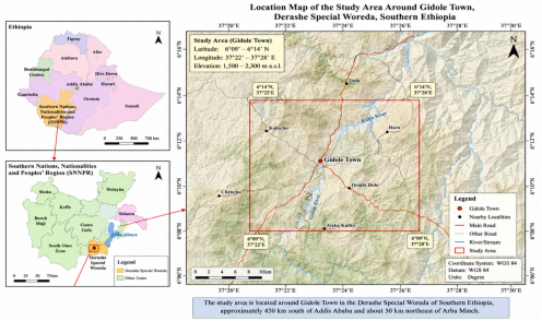
The study area is located around Gidole Town in the Derashe Special Woreda of Southern Ethiopia, approximately 450 km south of Addis Ababa and about 50 km northeast of Arba Minch. Geographically, it lies between 6°09′–6°14′ N latitude and 37°22′–37°28′ E longitude, covering an area characterized by rugged mountainous terrain within the western escarpment of the southern Ethiopian Rift System. The principal highway connecting Arba Minch and Gidole passes through the study area, providing access to the surrounding mountainous landscape where numerous historical and active landslides have been documented. Owing to its strategic location, recurrent slope failures frequently disrupt transportation, agricultural activities, and local socioeconomic development, highlighting the importance of detailed landslide hazard assessment.
Figure 1. Location map of study area.
2.2. Topography and Geomorphology
The study area exhibits rugged topography dominated by steep escarpments, deeply incised valleys, narrow ridges, and highly dissected hillslopes. Elevations range from approximately 1,400 m in the Rift Valley floor to more than 2,500 m above sea level near Gidole Town, resulting in a local relief exceeding 1,100 m. Such pronounced elevation differences generate high gravitational stresses that significantly influence slope stability.
Geomorphological evolution has been controlled by regional tectonic uplift, prolonged volcanic activity, differential weathering, fluvial erosion, and repeated mass movement processes
| [3] | Ayalew, L., & Yamagishi, H. (2005). The application of GIS-based logistic regression for landslide susceptibility mapping in the Kakuda-Yahiko Mountains, central Japan. Geomorphology65,15–31. http://doi.org/10.1016/j.geoorph.2004.06.010 |
[3]
. The terrain consists of convex hilltops, concave lower slopes, steep road cuts, and extensive colluvial accumulations. Numerous active gullies and stream channels incise the escarpment, producing continuous toe erosion that contributes to progressive slope instability. Field investigations revealed that most landslides occur along steep hillslopes where relief is greatest and weathered volcanic rocks are extensively exposed.
2.3. Climate
The study area experiences a tropical highland climate characterized by distinct wet and dry seasons. Climatic conditions vary considerably with altitude, producing two dominant agroecological zones: the Dega (highland) and Weyna Dega (mid-altitude) climatic regions.
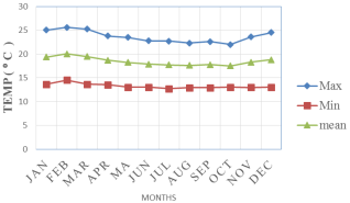
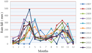
Figure 2, Mean annual temperatures generally range between 16°C and 29°C, whereas annual rainfall varies from approximately 800 to 1,400 mm, with nearly 80% of precipitation occurring during the Kiremt rainy season (June–September).
Figure 2. Temperature at study area.
Intense seasonal rainfall represents the principal triggering mechanism for landslide initiation in the area. Prolonged precipitation infiltrates through weathered volcanic rocks and unconsolidated colluvial deposits, increasing groundwater levels and pore-water pressure while simultaneously reducing effective stress and shear strength. Consequently, the majority of documented landslides occur during or immediately following periods of sustained rainfall. These observations emphasize the critical role of hydroclimatic conditions in controlling slope instability within the Gidole escarpment.
Figure 3. Graph showing rain for data for study area.
2.4. Drainage and Hydrological Conditions
The drainage system is structurally controlled by regional faults and fractures associated with the evolution of the Main Ethiopian Rift. Numerous perennial and seasonal streams dissect the mountainous terrain, forming predominantly dendritic and sub-parallel drainage patterns. Major streams, including the Rambu and Kittawe Rivers, flow eastward toward the Rift Valley.
Hydrological observations during field investigations identified numerous springs, seepage zones, and saturated colluvial deposits concentrated along weathered volcanic contacts and fault-controlled fracture systems. Groundwater emergence was particularly common within highly weathered basalt and pyroclastic deposits, where infiltration through interconnected discontinuities promotes continuous saturation of slope materials. These groundwater conditions significantly reduce soil and rock shear strength and are closely associated with active landslide locations identified during field mapping.
Figure 4. Effect of rain fall in the study area.
2.5. Geological Setting
The study area is situated within the southern sector of the Ethiopian Rift System, one of the most tectonically active segments of the East African Rift. Regional geological evolution reflects prolonged interaction between Precambrian basement rocks, Cenozoic volcanic activity, extensional tectonics, and Quaternary surface processes
| [3] | Ayalew, L., & Yamagishi, H. (2005). The application of GIS-based logistic regression for landslide susceptibility mapping in the Kakuda-Yahiko Mountains, central Japan. Geomorphology65,15–31. http://doi.org/10.1016/j.geoorph.2004.06.010 |
[3]
. The present landscape is predominantly composed of volcanic rocks and unconsolidated surficial deposits formed during successive volcanic eruptions and subsequent weathering.
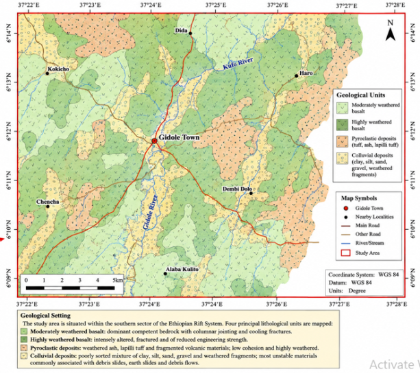
Detailed geological mapping identified four principal lithological units:
moderately weathered basalt, highly weathered basalt, pyroclastic deposits, and
colluvial deposits Figure 5. Basalt constitutes the dominant bedrock and exhibits well-developed columnar jointing, cooling fractures, and varying degrees of weathering. Fresh basalt generally forms competent rock masses, whereas highly weathered basalt displays substantial mineral alteration, extensive fracturing, and reduced engineering strength.
Pyroclastic deposits consist mainly of weathered volcanic ash, lapilli tuff, and fragmented volcanic materials. These deposits are characterized by relatively low cohesion and high susceptibility to weathering. Thick colluvial deposits occur extensively along lower hillslopes and valley margins, where prolonged gravitational transport has accumulated poorly sorted mixtures of clay, silt, sand, gravel, and weathered volcanic fragments. Field observations indicate that these unconsolidated deposits represent the most unstable engineering geological materials in the study area and are commonly associated with debris slides, earth slides, and debris flows.
Figure 5. Geological map of study area.
2.6. Structural Geology
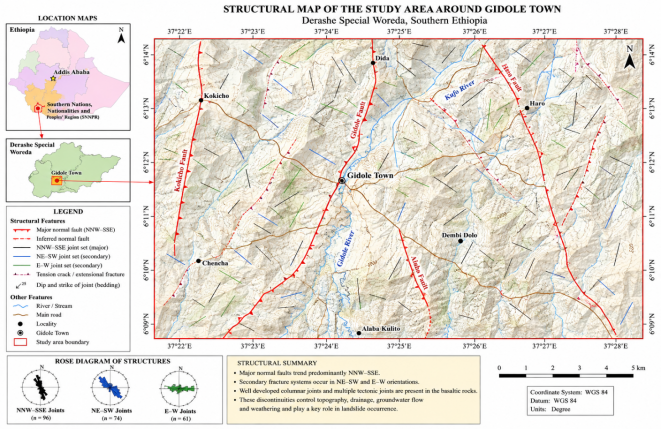
The structural framework of the study area is dominated by extensional tectonic structures associated with the development of the Ethiopian Rift System. Major normal faults trend predominantly
NNW–SSE, while secondary fracture systems occur in
NE–SW and
E–W orientations
Figure 7. These structures control topographic development, groundwater circulation, drainage alignment, and weathering intensity throughout the study area.
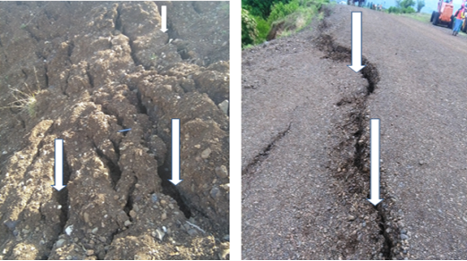
Basaltic rocks are characterized by well-developed columnar joints together with multiple tectonic joint sets exhibiting variable spacing, persistence, roughness, and aperture. These discontinuities provide preferential pathways for groundwater infiltration, accelerate chemical weathering, and reduce overall rock mass integrity. Several active tension cracks and displaced joint blocks were observed during field investigations, indicating ongoing slope deformation
Figure 6. The interaction of faulting, jointing, groundwater seepage, and intense weathering constitutes one of the principal mechanisms governing landslide occurrence around Gidole Town.
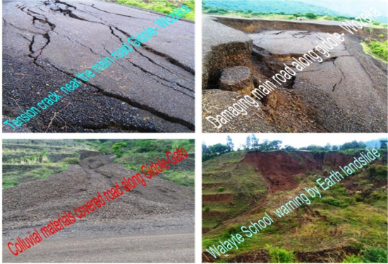
Figure 6. photo shows tension crack along road Gidole – Wozeka.
Figure 7. structural map of study area.
2.7. Land Use and Vegetation Cover
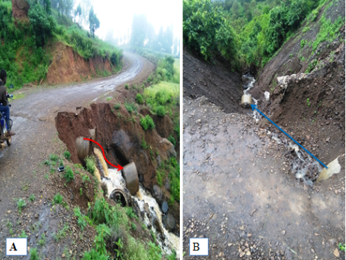
Land use within the study area is dominated by subsistence agriculture, mixed woodland, eucalyptus plantations, grazing land, and scattered rural settlements. Agricultural activities are concentrated on moderate slopes and valley bottoms, whereas steep hill slopes are partly covered by shrubs and remnant natural vegetation. In recent decades, increasing cultivation, road construction, deforestation, and settlement expansion. Field observations revealed that removal of natural vegetation has accelerated soil erosion and reduced root reinforcement, thereby decreasing slope stability
Figure 13A. Road excavations have locally over-steepened slopes without adequate stabilization or drainage measures, increasing susceptibility to landslides. Consequently, anthropogenic activities act as important secondary factors that exacerbate naturally unstable geological and geomorphological conditions.
3. Materials and Methods
3.1. Research Design
This study employed an integrated engineering geological and geographic information system (GIS)-based approach to evaluate landslide susceptibility around Gidole Town, southern Ethiopia. The methodology combined detailed field investigations, engineering geological characterization, laboratory testing, remote sensing, GIS analysis, and expert-based landslide hazard assessment using the Slope Stability Susceptibility Evaluation Parameter (SSEP) method. The overall workflow comprised three sequential phases: (i) pre-field investigation, (ii) field investigation, and (iii) post-field data processing and hazard analysis. This integrated framework enabled the systematic identification of causative factors controlling slope instability and facilitated the preparation and validation of a landslide hazard zonation map.
3.2. Pre-field Investigation
The pre-field phase involved collecting and reviewing available geological, topographic, climatological, and remote sensing data relevant to the study area. Published scientific literature, geological reports, previous landslide investigations, and regional geological maps were critically reviewed to establish the geological and geomorphological framework of the area. Topographic maps at a scale of 1:50,000, aerial photographs, satellite imagery, and regional geological maps were compiled and analyzed to delineate preliminary slope facets and identify potential landslide-prone areas.
Using GIS software, preliminary thematic layers representing lithology, slope morphology, relative relief, land use and land cover, drainage, geological structures, and surface geomorphology were prepared prior to field verification
| [4] | Bekele, A., Dramis, F., Fubelli, G., Umer, M., & Asrat, A. (2009). Landslides in the Ethiopian highlands and the Rift margins. Journal of African Earth Sciences, 56, 131–138. |
[4]
. These datasets served as the basis for planning field investigations and selecting representative sites for detailed engineering geological observations.
3.3. Field Investigation
Comprehensive field investigations were undertaken to verify the preliminary GIS interpretation and to collect primary engineering geological data. Detailed geological mapping was conducted to identify lithological units, weathering characteristics, structural discontinuities, geomorphological features, groundwater manifestations, and existing landslide occurrences. Structural measurements, including strike, dip, joint spacing, persistence, aperture, roughness, weathering, and infilling materials, were recorded using a Brunton compass and standardized engineering geological mapping procedures.
A systematic landslide inventory was developed through field reconnaissance, direct observations, interpretation of topographic features, and verification of remotely sensed imagery. Each landslide was documented using handheld GPS receivers, and information regarding landslide type, dimensions, slope geometry, failure mechanisms, and associated triggering factors was recorded
Figure 11, 12, 13, 14, 15, 16, 17 and 18. Particular attention was given to identifying active and reactivated landslides affecting transportation corridors, cultivated land, and residential areas.
Field observations also included assessment of groundwater seepage, spring locations, erosion features, road-cut instability, anthropogenic slope modifications, and vegetation conditions, all of which were incorporated into the hazard assessment.
3.4. Engineering Geological Investigation
Representative disturbed soil samples were collected from major landslide deposits and colluvial materials for laboratory analysis
| [17] | Raghuvanshi, T. K., Ibrahim, J., & Ayalew, D. (2014). Slope stability susceptibility evaluation parameter (SSEP) rating scheme—An approach for landslide hazard zonation. Journal of African Earth Sciences, 99, 595–612. |
[17]
. Grain-size distribution was determined using sieve analysis, whereas Atterberg limit tests were performed to determine liquid limit, plastic limit, and plasticity index
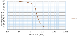
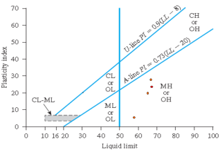
Table 1, 2, 3 and
Figure 8 & 9. Soil classification was carried out according to the Unified Soil Classification System (USCS), providing engineering parameters essential for understanding slope behavior. For soil classification many standards are available, however, for the present study the Unified soil classification system (USCS) has been adopted. To determine the Index properties of the soil in the area, the particle size distribution of the samples was determined from a gradation test (sieve analyses) and the liquid limit, plastic limit and plasticity index from Atterberg’s limit test.
Table 1. Grain size distribution of soil samples (S1) in the study area. Grain size distribution of soil samples (S1) in the study area. Grain size distribution of soil samples (S1) in the study area.
S1 |
Sieve opening (mm) |
9.5 | 416.00 | 419.20 | 3.20 | 0.64 | 0.64 | 99 |
4.75 | 451.00 | 454.50 | 3.50 | 0.70 | 1.34 | 99 |
2.36 | 394.00 | 399.40 | 5.40 | 1.08 | 2.42 | 98 |
2 | 394.00 | 400.70 | 6.70 | 1.34 | 3.76 | 96 |
1.18 | 358.00 | 366.30 | 8.30 | 1.66 | 5.42 | 95 |
0.85 | 339.00 | 352.60 | 13.60 | 2.72 | 8.14 | 92 |
0.6 | 318.00 | 337.90 | 19.90 | 3.98 | 12.12 | 88 |
0.425 | 299.00 | 343.00 | 44.00 | 8.80 | 20.92 | 79 |
0.3 | 285.00 | 417.50 | 132.50 | 26.50 | 47.42 | 53 |
0.15 | 292.00 | 449.80 | 157.80 | 31.56 | 78.98 | 21 |
0.075 | 280.00 | 336.90 | 56.90 | 11.38 | 90.36 | 10 |
can | 256.00 | 304.00 | 48.00 | 9.60 | 99.96 | 0.04 |
Figure 8. Grain size distribution curve for S1 (Sample one).
For all four samples, the percent pass for 0.075 mm (No 200, Standard sieves), was less than 50%.
Therefore, it is classified as coarse grained soils in the USCS classification systems. Since more than half of the coarse fractions (100%), of the samples are smaller than No 4 sieve size (4.75mm) soils are classified as sand. To determine whether in sand fraction there is an appreciable amount of fines or little, further, coefficient of uniformity Cu= D60/D10 and coefficient of curvature Cc= (D30)2/D10*D60 has been determined for each of the soil samples).
Table 2. coefficient of uniformity and curvature soil of the study area.
Sample No | D60 | D30 | D10 | Cc | Cu |
S1 | 0.3 | 0.2 | 0.8 | 1.43 | 4.38 |
S2 | 0.8 | 0.34 | 0.14 | 1.03 | 5.71 |
S3 | 0.43 | 0.2 | 0.09 | 1.05 | 4.72 |
S4 | 0.4 | 0.18 | 0.08 | 1.01 | 5 |
The value of ‘Cu is less than six (Cu< 6) and the value of coefficient of curvature is greater than one or less than three (Cc>1 or Cc< 3). Thus, from four samples, S1, S2, S3 and S4 are meeting graduation requirements for poorly graded sandwith silt.
Table 3. Atterberg limits analyzed and results for soil of the study area.
No | Location | Moisture content% | Atterberg limit | Classification of soil according to USCS. |
| | | LL | PL | PI | MH (Sandy elastic silt) |
S1 | Walayte | 23.66 | 66.29 | 42.73 | 23.56 | MH (Sandy elastic silt) |
S2 | Walayte | 28.15 | 64.23 | 41.67 | 22.56 | MH (Sandy elastic silt) |
S3 | Walayte | 23.42 | 65.89 | 35.42 | 30.47 | MH (Sandy elastic silt) |
S4 | Galo | 30.43 | 56.37 | 50 | 6.37 | ML (Sandy silty) |
From the Atterberg limit analysis
(Table 3) liquid limit vs. plasticity index has been plotted and all four samples fall below A- line. Therefore, it is classified as silty sand, sand-silt mixture. These kinds of soils have high water permeability capacity. Therefore, the water which percolates through the weathered profile, when it reaches to the low permeable media, the seepage forces develops and ultimately leads to potential instability of the slope. From plasticity index of the soils of study area the S-No1, S_N2 andS-No3 are grouped under medium to highplastic where the S-No4 is low plastic.
Therefore, it can be concluded from the above analysis that the soils of the study area have some clay content. However, it is in small amount thus soils in general possess low cohesion, same has been deduced from the laboratory results also. From field observation, the sticky clayey nature of the soil has been observed and it is dry. Moreover, the good permeability nature of the sand size soilparticles, allow infiltration of water which will saturate the slope material and thus, thereby induce slope instability.
Figure 9. Plasticity chart of the samples analyzed.
3.5. Landslide Inventory Mapping
A comprehensive landslide inventory map was prepared through integration of field observations, topographic interpretation, aerial photographs, and satellite imagery. Individual landslide features were delineated based on geomorphological characteristics, including scarps, displaced materials, tension cracks, hummocky topography, and disrupted drainage patterns.
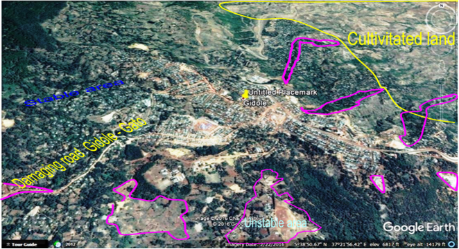
Figure 10. Identified landslides in study area by comparing actual field photo with taken from Google Earth (2016).
Each mapped landslide was classified according to its movement mechanism, dimensions, slope material, and activity status. The inventory map served as the primary dataset for evaluating relationships between landslide occurrence and causative factors and was subsequently used for validation of the landslide hazard zonation model
| [20] | Varnes (1978).Slope movements, types and processes. In: Schuster, R.L., Krizek, R.J. (eds.), Landslide analysis and control, National Academy Sciences, Washington DC, 11-33. |
[20]
.
3.6. Slope Stability Susceptibility Evaluation Parameter (SSEP) Method
Landslide hazard assessment was conducted using the
Slope Stability Susceptibility Evaluation Parameter (SSEP) method developed by Raghuvanshi et al. (2014). The SSEP method is a semi-quantitative expert evaluation technique that integrates intrinsic slope characteristics with external triggering factors to estimate the relative probability of landslide occurrence
| [8] | Fall, M., Azzam, R., & Noubactep, C. (2006). A multi-method approach to study the stability of natural slopes and landslide susceptibility mapping. Engineering Geology, 82(4) 241–263. |
[8]
.
Nine principal causative factors were incorporated into the analysis. Intrinsic parameters included lithology, slope morphology, relative relief, structural discontinuities, land use and land cover, and groundwater conditions. External triggering factors comprised rainfall, seismicity, and anthropogenic activities. Each parameter was assigned a rating according to its relative influence on slope stability, and cumulative ratings were calculated for each slope facet to obtain the Evaluated Landslide Hazard (ELH) index.
The ELH values were subsequently classified into hazard categories representing low, moderate, high, and very high landslide susceptibility. The resulting hazard classes formed the basis for the preparation of the final landslide hazard zonation map.
3.7. Geographic Information System (GIS) Analysis
Spatial analysis and map preparation were performed using Geographic Information System (GIS) software. Individual thematic layers representing lithology, structural geology, slope morphology, relative relief, land use, drainage, groundwater conditions, rainfall distribution, and landslide inventory were digitized, georeferenced, and integrated within the GIS environment.
Slope facets were generated to represent relatively homogeneous terrain units, and attribute data for each causative factor were assigned accordingly. GIS overlay analysis was employed to combine thematic datasets and calculate the cumulative SSEP ratings for individual slope facets. The final landslide hazard zonation map was produced by classifying cumulative ELH values into predefined hazard categories.
3.8. Validation of the Hazard Zonation Map
The reliability of the prepared landslide hazard zonation map was evaluated using the independent landslide inventory compiled during field investigations. Validation was performed by comparing the spatial distribution of documented landslides with the predicted hazard classes
| [7] | Chingkhei, R., Shiroyleima, A., Singh, R. L., & Kumar, A. (2013). Landslide hazard zonation in NH-1A in Kashmir Himalaya. International Journal of Geosciences, 4, 1501–1508. |
[7]
. The percentage of observed landslides occurring within each hazard category was calculated to evaluate the predictive capability of the SSEP model.
A satisfactory hazard model is expected to classify the majority of observed landslides within the high- and very high-hazard zones. The validation results demonstrated good agreement between observed landslide locations and predicted hazard classes, confirming the suitability of the SSEP method for regional landslide hazard assessment in the Gidole area.
4. Results
4.1. Geological and Geomorphological Characteristics
Field investigations revealed that the study area comprises a heterogeneous assemblage of volcanic and unconsolidated sedimentary materials that exert strong control on slope stability
Figure 15. Four principal lithological units were identified: moderately weathered basalt, highly weathered basalt, pyroclastic deposits, and unconsolidated colluvial deposits. Basalt constitutes the dominant bedrock and is extensively exposed along road cuts, river valleys, and escarpments. The basalt commonly exhibits moderate to advanced weathering, well-developed columnar jointing, closely spaced fractures, and local vesicular textures. These discontinuities reduce the mechanical strength of the rock mass and facilitate infiltration of surface water, thereby accelerating weathering and promoting progressive slope failure.
Pyroclastic deposits are mainly composed of volcanic ash, lapilli tuff, and weathered volcanic fragments. Owing to their relatively weak mechanical properties and high susceptibility to weathering, these deposits form unstable slope materials, particularly where saturated during the rainy season. Thick colluvial deposits derived from prolonged weathering and downslope transport of volcanic materials accumulate at the base of steep escarpments. These unconsolidated deposits represent the weakest engineering geological unit within the study area and were frequently associated with active debris slides and earth slides observed during field investigations.
Geomorphologically, the study area is characterized by rugged terrain with steep escarpments, deeply incised valleys, convex hilltops, and narrow ridges. Local relief commonly exceeds 1,000 m, creating high gravitational stresses that contribute significantly to slope instability. Stream erosion along valley bottoms has resulted in continuous toe undercutting, whereas intense surface runoff has promoted gully erosion and progressive removal of slope-supporting materials. These geomorphological conditions collectively enhance landslide susceptibility throughout the area.
4.2. Landslide Inventory
A detailed landslide inventory identified numerous slope failures distributed throughout the study area, with the highest concentration occurring along steep road cuts and escarpments developed on highly weathered volcanic rocks.
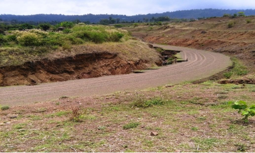
Figure 11. Damaged roads by landslide.
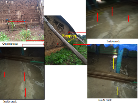
Figure 12. Police station that under risk and different cracking inside and outside of house.
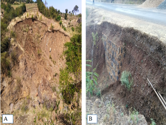
Figure 13. A Damaging farmland. B, Damaging of pipe line, retain wall and road under risk.

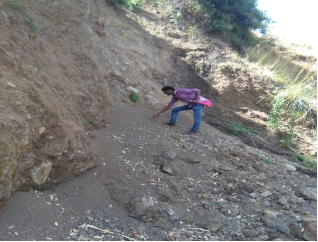
Figure 14. Effects of different landslide in study area.
The mapped landslides include rotational slides, translational slides, debris slides, debris flows, rock falls, and complex failures, reflecting the diverse geological and geomorphological conditions.
Rotational and translational slides are predominantly associated with highly weathered basalt and thick colluvial deposits, whereas debris flows occur mainly during periods of intense rainfall when unconsolidated materials become saturated. Rock falls are generally confined to steep cliffs and road-cut exposures where persistent joint sets, fractures, and weathering have weakened the rock mass. Several landslides exhibit evidence of repeated reactivation, indicating persistent instability driven by seasonal rainfall, groundwater seepage, and ongoing weathering.
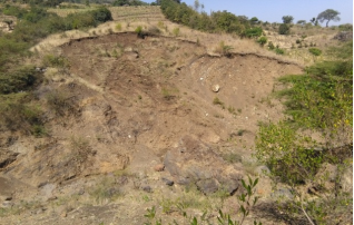
Figure 15. Rotational Slide.
In this kind of slide the surface of rupture is curved concavely upward and the slide movement is roughly rotational about an axis that is parallel to the ground surface. The majority of farmland in study area is damaging by rotational slides.
Rock falls/ Soil falls is some types of landslide in the study area. This type of slide observed at very steeply cut natural and artificial slopes of the study area.
Which is composed of soils, sands, gravels, and boulders with plant roots and vegetation observed in the study area Next to the debris falls type of slope instability of study area are debris flows.
which is rare in the study area. However this type of slide observed at very steeply cut natural and artificial slopes of the study area.
Field observations indicate that most landslides initiated on slopes steeper than approximately 25°, particularly where groundwater seepage emerged from weathered volcanic horizons. Human activities, including road excavation, slope cutting, inadequate drainage, and agricultural expansion, further contributed to instability by disturbing the natural equilibrium of slopes and increasing surface erosion. These findings demonstrate that landslide occurrence in the study area results from the combined influence of unfavorable geological conditions and anthropogenic modifications.
4.3. Engineering Properties of Soils
Laboratory analyses demonstrate that the dominant soils within the study area consist primarily of silty clay, clayey silt, and sandy clay derived from prolonged weathering of volcanic rocks. Grain-size analysis indicates variable proportions of gravel, sand, silt, and clay depending on parent material and geomorphic setting.
Atterberg limit testing revealed moderate to high plasticity characteristics, indicating significant volume changes under varying moisture conditions. According to the Unified Soil Classification System (USCS), the majority of soil samples were classified as fine-grained cohesive soils with moderate engineering performance. During the rainy season, increased moisture content substantially reduces effective stress and shear strength, thereby facilitating the initiation of shallow landslides and debris flows. These laboratory results are consistent with field observations of saturated colluvial deposits associated with active slope failures.
4.4. Landslide Hazard Zonation
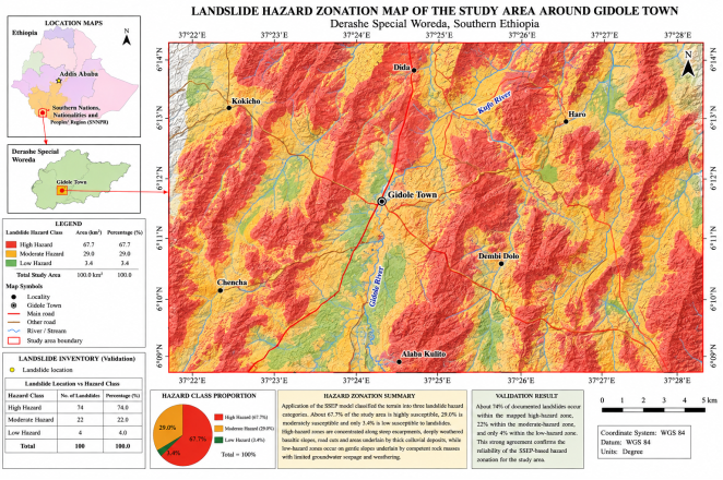
Application of the Slope Stability Susceptibility Evaluation Parameter (SSEP) model produced a comprehensive landslide hazard zonation map for the study area.
Figure 19. The integrated analysis of lithology, slope morphology, relative relief, structural discontinuities, groundwater conditions, rainfall, land use, seismicity, and anthropogenic activities classified the terrain into three principal hazard categories: low, moderate, and high susceptibility.
The hazard map indicates that approximately 67.7% of the study area falls within the high-hazard category, 29.0% is classified as moderately hazardous, and only 3.4% is categorized as low hazard. High-hazard zones are concentrated along steep escarpments, deeply weathered basaltic slopes, road cuts, and areas underlain by thick colluvial deposits. In contrast, low-hazard areas generally occur on gentle slopes underlain by comparatively competent rock masses with limited evidence of groundwater seepage and weathering.
Figure 19. Hazard zonation map of study area.
4.5. Validation of the Hazard Model
Validation of the hazard zonation map using the independently prepared landslide inventory demonstrated strong agreement between observed landslide locations and predicted hazard classes
| [10] | Fikre, G. (2010). A multi-method approach to study landslide hazard: A case study in Adaberga Woreda, Western Shoa Zone, Oromia Region, Ethiopia [Unpublished master's thesis]. Addis Ababa University, Addis Ababa, Ethiopia. |
| [15] | Manoj K. Arora R. Anbalagan (2010). Overview of Landslide Hazard and Risk Practices in India.Department of Civil Eng. & Earth Sciences Indian Institute of Technology Roorkee. Insitutional technical report. |
[10, 15]
. Approximately
74% of documented landslides occurred within the mapped high-hazard zone, whereas comparatively few landslides were identified within moderate- and low-hazard areas. This correspondence confirms the reliability of the SSEP approach in representing the spatial distribution of landslide-prone terrain within the study area.
The successful validation indicates that the integrated consideration of geological, geomorphological, hydrological, and anthropogenic factors provides a robust basis for regional landslide hazard assessment
| [13] | Kanungo, D. P., Arora, M. K., Sarkar, S., & Gupta, R. P. (2006). A comparative study of conventional, ANN black box, fuzzy and combined neural and fuzzy weighting procedures for landslide susceptibility zonation in Darjeeling Himalayas. Engineering Geology, 85, 347–366. |
[13]
. The resulting hazard map therefore constitutes a valuable decision-support tool for infrastructure planning, slope stabilization, disaster risk reduction, and sustainable land management in Gidole and similar volcanic terrains of Ethiopia.
5. Discussion
5.1. Controls on Landslide Occurrence
The results demonstrate that landslide occurrence around Gidole Town is governed by the combined influence of geological, geomorphological, hydrological, and anthropogenic factors rather than by any single triggering mechanism. The widespread occurrence of highly weathered basalt, pyroclastic deposits, and unconsolidated colluvial materials has significantly reduced the mechanical competence of slope-forming materials. Weathering has transformed originally strong volcanic rocks into fractured and weakened rock masses characterized by low shear strength, high permeability, and poor structural integrity. These conditions promote groundwater infiltration, reduce effective stress, and facilitate the initiation of both shallow and deep-seated landslides.
Topography also exerts a dominant influence on landslide development. The study area is characterized by steep escarpments, deeply incised valleys, and local relief exceeding 1,000 m, which increase gravitational driving forces acting on hillslopes. Steep slopes promote rapid surface runoff, toe erosion, and continuous removal of slope-supporting materials. These geomorphological conditions, combined with structurally controlled drainage systems, create favorable environments for progressive slope deformation and eventual failure. Similar relationships between steep terrain and landslide occurrence have been reported in other volcanic regions of Ethiopia and elsewhere, emphasizing the importance of slope gradient and relief in regional landslide susceptibility assessment.
Hydrological conditions represent another critical factor influencing slope instability. Field observations revealed numerous groundwater seepage zones, springs, and saturated colluvial deposits located near active landslides. Seasonal rainfall infiltrates through joints, fractures, and weathered volcanic rocks, increasing pore-water pressure while reducing effective stress and shear strength. Consequently, many landslides occur during or immediately after periods of intense rainfall when saturation levels are highest. The observed association between groundwater seepage and landslide occurrence indicates that effective surface and subsurface drainage systems are essential for reducing future landslide hazards in the study area.
5.2. Engineering Geological Implications
Laboratory analyses further indicate that the dominant soils possess moderate to high plasticity characteristics and exhibit appreciable reductions in shear strength when saturated. Fine-grained colluvial deposits accumulated along steep slopes therefore constitute particularly unstable materials during prolonged rainfall. These findings emphasize that engineering design in the study area should incorporate comprehensive geotechnical investigations, appropriate slope stabilization measures, controlled excavation practices, and effective drainage systems to minimize future instability.
5.3. Performance of the SSEP Hazard Assessment Method
The Slope Stability Susceptibility Evaluation Parameter (SSEP) method proved to be an effective tool for regional landslide hazard assessment in the Gidole area. The integration of intrinsic geological factors and external triggering conditions enabled systematic evaluation of slope stability despite the limited availability of long-term geotechnical monitoring data. The hazard zonation map successfully identified the majority of documented landslides within the predicted high-hazard zones, demonstrating the capability of the SSEP approach to represent the spatial distribution of unstable terrain
| [18] | Samuel, M. (2011). Slope stability analysis: A case study of selected slope sections along Gohatsion–Degen Road, Amhara Region, Ethiopia. Addis Ababa University, Addis Ababa, Ethiopia. |
[18]
.
Compared with purely statistical or machine-learning approaches, the SSEP method offers several advantages for data-scarce regions. It explicitly incorporates engineering geological expertise, allows systematic weighting of multiple causative factors, and can be implemented using readily available geological and geomorphological information. These characteristics make the approach particularly suitable for mountainous regions of Ethiopia where detailed geotechnical datasets are often unavailable. Nevertheless, future studies could further improve hazard prediction by integrating high-resolution digital elevation models, rainfall intensity records, geophysical investigations, and machine-learning algorithms with the existing SSEP framework.
5.4. Comparison with Previous Studies
The results obtained in this investigation are consistent with previous engineering geological studies conducted in different parts of Ethiopia, which identify weathered volcanic rocks, steep topography, intense seasonal rainfall, and groundwater seepage as the principal factors controlling landslide occurrence. Studies from the Ethiopian Highlands have similarly demonstrated that landslides frequently develop within highly weathered basaltic terrains where extensive jointing and deep weathering reduce rock mass strength. The predominance of rotational slides, debris slides, and earth slides observed around Gidole is therefore consistent with regional landslide characteristics documented throughout the Ethiopian Rift escarpments.
Internationally, the findings also agree with studies undertaken in volcanic mountain belts of Asia, South America, and East Africa, where the interaction of volcanic lithology, intense rainfall, groundwater, and anthropogenic slope modification governs slope instability. This consistency suggests that the engineering geological processes identified in the present study are representative of many volcanic terrains worldwide and confirms the applicability of the adopted methodology beyond the immediate study area.
5.5. Implications for Land Use and Infrastructure Development
The landslide hazard zonation map developed in this study provides an important scientific basis for land-use planning, infrastructure development, and disaster risk management in southern Ethiopia. Areas classified as high hazard should be prioritized for detailed geotechnical investigation before future construction activities are undertaken. Road alignments traversing highly weathered basalt and thick colluvial deposits should incorporate adequate drainage systems, retaining structures, slope reinforcement, and continuous monitoring to reduce the likelihood of future failures.
The hazard map can also assist regional planners in identifying suitable locations for urban expansion while avoiding unstable hillslopes. Furthermore, implementation of vegetation restoration, controlled land-use practices, erosion control measures, and public awareness programs would contribute substantially to reducing landslide risk and improving the long-term resilience of local communities.
Abbreviations
CC | Coefficient e Curvuture |
CC | Coefficient Uniformity |
ELH | Evaluation of Landslide Hazard |
GIS | Geographic Information System |
S1 | Sample Number One |
SSSEP | Slope Stability Susceptibility Evaluation Parameter |
USCS | Unified Soil Classification System |
Author Contributions
Mulugeta Emana: Conceptualization, Data curation, Formal Analysis, Investigation, Methodology, Writing – original draft
Gebremedhin Berhane: Conceptualization, Methodology, Project administration, Resources, Supervision, Writing – review & editing
Conflicts of Interest
The authors declare no conflicts of interest.
References
| [1] |
Ayalew .L(1999) .The effect of seasonal rainfall on landslides in the highlands of Ethiopia Bull Eng Geol Env (1999) 58: 9–19.
|
| [2] |
Alemayehu Regassa, K., Van Daele, P., De Paepe, M., Dumon, J., Deckers, J., Asrat, A., & Van Ranst, E. (2014). Characterizing weathering intensity and trends of geological materials in the Gilgel Gibe catchment, southwestern Ethiopia. Journal of of African earth sciences, 99,568-580.
http://doi.org/10.1016/j.jafrearsci.2014.05.01
|
| [3] |
Ayalew, L., & Yamagishi, H. (2005). The application of GIS-based logistic regression for landslide susceptibility mapping in the Kakuda-Yahiko Mountains, central Japan. Geomorphology65,15–31.
http://doi.org/10.1016/j.geoorph.2004.06.010
|
| [4] |
Bekele, A., Dramis, F., Fubelli, G., Umer, M., & Asrat, A. (2009). Landslides in the Ethiopian highlands and the Rift margins. Journal of African Earth Sciences, 56, 131–138.
|
| [5] |
Berhanu, T., Umar, M., & Korme, T. (2001). Natural hazard assessment using GIS and remote sensing methods with particular reference to landslides in the Wondogenet area, Ethiopia. Physics and Chemistry of the Earth, Part C: Solar, Terrestrial & Planetary Science, 26, 665–675.
https://doi.org/10.1016/S1464-1917(01)00065-4
|
| [6] |
Bonini, M., Corti, G., Innocenti, F., Manetti, P., Mazzarini, F., Abebe, T., & Pecskay, Z. (2005). Evolution of the Main Ethiopian Rift in the frame of Afar and Kenya rifts propagation. Tectonics, 24, TC1001.
|
| [7] |
Chingkhei, R., Shiroyleima, A., Singh, R. L., & Kumar, A. (2013). Landslide hazard zonation in NH-1A in Kashmir Himalaya. International Journal of Geosciences, 4, 1501–1508.
|
| [8] |
Fall, M., Azzam, R., & Noubactep, C. (2006). A multi-method approach to study the stability of natural slopes and landslide susceptibility mapping. Engineering Geology, 82(4) 241–263.
|
| [9] |
Fell, R., Corominas, J., Bonnard, C., Cascini, L., Leroi, E., & Savage, W. Z. (2008). Guidelines for landslide susceptibility, hazard and risk zoning for land use planning. Engineering Geology, 102, 85–98.
|
| [10] |
Fikre, G. (2010). A multi-method approach to study landslide hazard: A case study in Adaberga Woreda, Western Shoa Zone, Oromia Region, Ethiopia [Unpublished master's thesis]. Addis Ababa University, Addis Ababa, Ethiopia.
|
| [11] |
Henok, W. (2008). Landslide hazard zonation mapping in Blue Nile Gorges [Unpublished master's thesis]. Addis Ababa University, Addis Ababa, Ethiopia.
|
| [12] |
Ibrahim, J. (2011). Landslide assessment and hazard zonation in Mersa and Wurgessa area, North Wollo, Ethiopia. Addis Ababa University, Addis Ababa, Ethiopia.
|
| [13] |
Kanungo, D. P., Arora, M. K., Sarkar, S., & Gupta, R. P. (2006). A comparative study of conventional, ANN black box, fuzzy and combined neural and fuzzy weighting procedures for landslide susceptibility zonation in Darjeeling Himalayas. Engineering Geology, 85, 347–366.
|
| [14] |
Kifle, W. (2013). Review of the occurrences and influencing factors of landslides in the highlands of Ethiopia: With implications for infrastructural development.Momona Ethiopian Journal of Earth Sciences(MESJS), 5(1),3-31.doi.or..
|
| [15] |
Manoj K. Arora R. Anbalagan (2010). Overview of Landslide Hazard and Risk Practices in India.Department of Civil Eng. & Earth Sciences Indian Institute of Technology Roorkee. Insitutional technical report.
|
| [16] |
Neaupane, K. M., & Piantanakulchai, M. (2006). Analytic network process model for landslide hazard zonation. Engineering Geology, 85, 281–294.
http://doi.org10.1016/j.enggeo.2006.02.003
|
| [17] |
Raghuvanshi, T. K., Ibrahim, J., & Ayalew, D. (2014). Slope stability susceptibility evaluation parameter (SSEP) rating scheme—An approach for landslide hazard zonation. Journal of African Earth Sciences, 99, 595–612.
|
| [18] |
Samuel, M. (2011). Slope stability analysis: A case study of selected slope sections along Gohatsion–Degen Road, Amhara Region, Ethiopia. Addis Ababa University, Addis Ababa, Ethiopia.
|
| [19] |
Tenalem, A., & Barbieri, G. (2004). Inventory of landslides and susceptibility mapping in the Dessie area, northern Ethiopia. Engineering Geology, 77, 1–15.
|
| [20] |
Varnes (1978).Slope movements, types and processes. In: Schuster, R.L., Krizek, R.J. (eds.), Landslide analysis and control, National Academy Sciences, Washington DC, 11-33.
|
Cite This Article
-
APA Style
Emana, M., Berhane, G. (2026). Engineering Geological Assessment and Landslide Hazard Zonation Using the Slope Stability Susceptibility Evaluation Parameter Method Around Gidole Town, Southern Ethiopia. iResearch, 1(2), 76-92. https://doi.org/10.11648/j.ir.20260102.12
 Copy
|
 Download
ACS Style
Emana, M.; Berhane, G. Engineering Geological Assessment and Landslide Hazard Zonation Using the Slope Stability Susceptibility Evaluation Parameter Method Around Gidole Town, Southern Ethiopia. iRes. 2026, 1(2), 76-92. doi: 10.11648/j.ir.20260102.12
Copy
|
Download
AMA Style
Emana M, Berhane G. Engineering Geological Assessment and Landslide Hazard Zonation Using the Slope Stability Susceptibility Evaluation Parameter Method Around Gidole Town, Southern Ethiopia. iRes. 2026;1(2):76-92. doi: 10.11648/j.ir.20260102.12
Copy
|
Download
-
@article{10.11648/j.ir.20260102.12,
  author = {Mulugeta Emana and Gebremedhin Berhane},
  title = {Engineering Geological Assessment and Landslide Hazard Zonation Using the Slope Stability Susceptibility Evaluation Parameter Method Around Gidole Town, Southern Ethiopia},
  journal = {iResearch},
  volume = {1},
  number = {2},
  pages = {76-92},
  doi = {10.11648/j.ir.20260102.12},
  url = {https://doi.org/10.11648/j.ir.20260102.12},
  eprint = {https://article.sciencepublishinggroup.com/pdf/10.11648.j.ir.20260102.12},
  abstract = {Gidole Town and its surrounding areas have experienced repeated landslide events that have damaged roads, farmland, and settlements, yet detailed engineering geological investigations and quantitative hazard assessments remain limited. This study investigates the engineering geological factors controlling slope instability and develops a landslide hazard zonation map using the Slope Stability Susceptibility Evaluation Parameter (SSEP) method. The research integrates detailed geological and geomorphological mapping, structural discontinuity measurements, landslide inventory mapping, laboratory testing of representative soil samples, and Geographic Information System (GIS)-based spatial analysis. The results show that highly weathered basalt, unconsolidated colluvial deposits, steep slopes, groundwater seepage, and intense seasonal rainfall are the primary controls on landslide occurrence in the study area. The hazard zonation model classified 67.7% of the area as high hazard, 29.0% as moderate hazard, and 3.4% as low hazard. Model validation using the mapped landslide inventory indicated that approximately 74% of documented landslides fall within the predicted high-hazard zones, demonstrating the robustness and reliability of the SSEP approach. The resulting hazard map provides a scientific basis for land-use planning, infrastructure development, slope stabilization, and disaster risk reduction in southern Ethiopia. The findings further demonstrate that the SSEP method is an effective and practical tool for landslide hazard assessment in data-constrained mountainous regions.},
 year = {2026}
}
Copy
|
Download
-
TY  - JOUR
T1  - Engineering Geological Assessment and Landslide Hazard Zonation Using the Slope Stability Susceptibility Evaluation Parameter Method Around Gidole Town, Southern Ethiopia
AU  - Mulugeta Emana
AU  - Gebremedhin Berhane
Y1  - 2026/10/28
PY  - 2026
N1  - https://doi.org/10.11648/j.ir.20260102.12
DO  - 10.11648/j.ir.20260102.12
T2  - iResearch
JF  - iResearch
JO  - iResearch
SP  - 76
EP  - 92
PB  - Science Publishing Group
UR  - https://doi.org/10.11648/j.ir.20260102.12
AB  - Gidole Town and its surrounding areas have experienced repeated landslide events that have damaged roads, farmland, and settlements, yet detailed engineering geological investigations and quantitative hazard assessments remain limited. This study investigates the engineering geological factors controlling slope instability and develops a landslide hazard zonation map using the Slope Stability Susceptibility Evaluation Parameter (SSEP) method. The research integrates detailed geological and geomorphological mapping, structural discontinuity measurements, landslide inventory mapping, laboratory testing of representative soil samples, and Geographic Information System (GIS)-based spatial analysis. The results show that highly weathered basalt, unconsolidated colluvial deposits, steep slopes, groundwater seepage, and intense seasonal rainfall are the primary controls on landslide occurrence in the study area. The hazard zonation model classified 67.7% of the area as high hazard, 29.0% as moderate hazard, and 3.4% as low hazard. Model validation using the mapped landslide inventory indicated that approximately 74% of documented landslides fall within the predicted high-hazard zones, demonstrating the robustness and reliability of the SSEP approach. The resulting hazard map provides a scientific basis for land-use planning, infrastructure development, slope stabilization, and disaster risk reduction in southern Ethiopia. The findings further demonstrate that the SSEP method is an effective and practical tool for landslide hazard assessment in data-constrained mountainous regions.
VL  - 1
IS  - 2
ER  -
Copy
|
Download




 Share This Article
 Twitter
 Linked In
 Facebook