The Mesozoic sedimentary basins in Ethiopia, particularly the Central Ethiopia, and Blue Nile Basin within the central main Ethiopian rift region are characterized by a diverse range of volcano-sedimentary rocks dominated by sedimentary sequences. The lithostratigraphy and petrology of Mesozoic sedimentary rocks of Lemi area, North Shewa, in Central Ethiopia within the Blue Nile basin, is described based on detailed field observations, lithostratigraphic analysis, petrographic examinations. The lithological units identified during fieldwork include Mudstone, Sandstone, and Basaltic rock formations. The sandstone unit in the study covers an estimated average thickness is 237 meters with intercalations of thinly bedded mudstone. The average thickness of each sandstone units (coarse (23 meters), medium (90 meters) and fine-grained (115 meters) sandstone unit) are varying from place to place within the study area. The stratigraphic section logs in four each block (Geza Washa, Dalota, Ruka, and Gosh Wiha) shows coarsening upward indicating the depositional environment transition from deep marine to the fluvial environment. The results of the study reveal the geological history and paleoenvironmental conditions of the Mesozoic sedimentary rocks in the Lemi area. This study contributes to our understanding of the geological processes that have influenced the formation of the Lemi area and provides valuable interpretations of regional geology.
This is an Open Access article, distributed under the terms of the Creative Commons Attribution 4.0 International License (http://creativecommons.org/licenses/by/4.0/), which permits unrestricted use, distribution and reproduction in any medium or format, provided the original work is properly cited.
The establishment of a detailed lithostratigraphic and petrographic framework of the Mesozoic sedimentary rocks is crucial for our broader understanding of Earth's past environments and tectonic processes. Ethiopian Mesozoic Sedimentary basins are the part of East African Rift System, a tectonically active region characterized by extensional Rifting and volcanic activity
[9]
Ebinger, C. J., Becker, T., & Ring, U. (1993). Tectonic controls on rift basin morphology: evolution of the Northern Malawi (Nyasa) Rift Tectonic Controls on Rift Basin Morphology’ Evolution of the Northern Malawi (Nyasa) Rift. November 2016.
Enkurie, D. (2010). Adigrat Sandstone in Northern and Central Ethiopia: Stratigraphy, Facies, Depositional Environments and Palynology (PhD Thesis). Technical University of Berlin.
[11]
Gani, N., Abdelsalam., G., Gera, M., & Gani, R. (2008). Stratigraphic and Structural Evolution of the Blue Nile Basin, Northwestern Ethiopian Plateau. Geological Journal, 44(1), 30–56.
Kazmin, V., Shifferaw, A., & Balcha, T. (1978). The Ethiopian basement: Stratigraphy and possible manner of evolution. Geologische Rund., 67(2), 531–546.
. Analyzing the petrographic characteristics of these sedimentary rocks is used to determine their mineral composition, texture, and diagenetic history
[18]
Wolela, A. (2009). Sedimentation and Depositional Environments of the Barremian-Cenomanian Debre Libanose Sandstone, Blue Nile (Abay) Basin, Ethiopia.
. In Central Ethiopia, specifically the Lemi area in North Shewa, the sedimentary rocks are the Central Main Ethiopia rift region, which holds a key to unraveling the region's geological history, and tectonic and paleoenvironmental conditions. Despite the geological significance of the Mesozoic sedimentary rocks in the Lemi area of North Shewa, Central Ethiopia, there is a lack of comprehensive lithostratigraphic and petrographic studies. The existing knowledge gap hinders a thorough understanding of the rock formations' composition, structure, and depositional history, limiting their potential contributions to local and regional geological and paleoenvironmental reconstructions. Therefore, a detailed study investigation into lithostratigraphy and petrography of these Mesozoic sedimentary rocks is essential to fill this research gap and enhance our understanding of the geological evolution of the region. This study aims to establish and explore the lithostratigraphy and petrography of the Mesozoic sedimentary rocks in the Lemi area, to assess the geologic and tectonic processes, and paleoenvironmental conditions that have shaped this region over time.
2. Regional Geologic Setting and Stratigraphy Succession
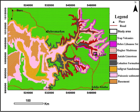
The regional geology of Blue Nile Basin in Central Ethiopia consists of up to 2600 m of the Paleozoic-Mesozoic sedimentary basins of Ethiopia belonging to the Karroo Rift System lies on the Precambrian basement unit
[10]
Enkurie, D. (2010). Adigrat Sandstone in Northern and Central Ethiopia: Stratigraphy, Facies, Depositional Environments and Palynology (PhD Thesis). Technical University of Berlin.
[10]
(Figure 1 & Figure 2). The Debre Libanos Sandstone is situated regionally in central and Northeastern part of Blue Nile Basin
[18]
Wolela, A. (2009). Sedimentation and Depositional Environments of the Barremian-Cenomanian Debre Libanose Sandstone, Blue Nile (Abay) Basin, Ethiopia.
. The basement rock units predominantly comprise gneissic and schistose rocks, often intersected by veins and dike intrusions
[14]
Kazmin, V., Shifferaw, A., & Balcha, T. (1978). The Ethiopian basement: Stratigraphy and possible manner of evolution. Geologische Rund., 67(2), 531–546.
Woldemichael, B. W., Kimura, JI., Dunkley, D. J. et al. SHRIMP. ((2010). U–Pb zircon geochronology and Sr–Nd isotopic systematic of the Neoproterozoic Ghimbi-Nedjo mafic to intermediate intrusions of Western Ethiopia: a record of passive margin magmatism at 855 Ma? Int J Earth Sci (Geol Rundsch) 99, 1773–1790.
. Overlying this basement rock is the Permo-Triassic Karoo succession, occurring unconformably
[2]
Alemu, T. (2021). Tectonic Evolution of the Pan-African Belt in Western Ethiopia, Southern Arabian-Nubian Shield. In: Hamimi, Z., Fowler, AR., Liégeois, JP., Collins, A., Abdelsalam, M. G., Abd EI-Wahed, M. (eds) The Geology of the Arabian-Nubian Shield. Regional Geology Reviews. Springer, Cham.
. The age of these rocks is estimated to be Neoproterozoic, with U-Pb and Rb-Sr geochronological studies indicating an age range from 850 to 550 million years
[19]
Wolfenden, E., Ebinger, C., Yirgu, G., Deino, A., & Ayalew, D. (2004). Evolution of the Northern Main Ethiopian Rift: Birth of a Triple Junction. Earth and Planetary Science Letters, 224(1-2), 213-228.
. Directly overlaying these Neoproterozoic rocks is the Adigrat Sandstone unit, also known as the lower sandstone. This formation is widely distributed across the Blue Nile Basin, Ogaden Basin, and Mekele Basin which occurs as the oldest sedimentary deposits in the region, forming the lowest stratigraphic section within Ethiopia's sedimentary basins
[7]
Beyth, M. (1972). Paleozoic-Mesozoic Sedimentary Basin of Mekele Outlier, Northern Ethiopia. AAPG Bulletin, 56(12), 2426-2439.
Enkurie, D. (2010). Adigrat Sandstone in Northern and Central Ethiopia: Stratigraphy, Facies, Depositional Environments and Palynology (PhD Thesis). Technical University of Berlin.
[10]
noted that this formation unconformably overlies the pre-Adigrat sandstone of Paleozoic sediments and attains a thickness of approximately 300 meters in the Dejen to Gohastion area of the Blue Nile basin and is characterized by its pink to red hues and fine to coarse-grained sandstone texture, occasionally interspersed with grey mudstone beds. The Adigrat sandstone formation is interpreted to have been deposited in alluvial fan, meandering, and lacustrine depositional environments
[7]
Beyth, M. (1972). Paleozoic-Mesozoic Sedimentary Basin of Mekele Outlier, Northern Ethiopia. AAPG Bulletin, 56(12), 2426-2439.
, originating from the weathering of quartzose sedimentary rocks sourced from silicic to intermediate granitoids
[12]
Getaneh, W. (2002). Geochemistry Provenance and Depositional Tectonic Setting of the Adigrat Sandstone Northern Ethiopia. Journal of African Earth Sciences, 35(2), 185-198.
. Sitting stratigraphically above the Adigrat Sandstone is the Glauconitic Sandy Mudstone unit, which in turn is overlain by the Gohatsion formation. This unit has an approximate thickness of 30 meters
[11]
Gani, N., Abdelsalam., G., Gera, M., & Gani, R. (2008). Stratigraphic and Structural Evolution of the Blue Nile Basin, Northwestern Ethiopian Plateau. Geological Journal, 44(1), 30–56.
and was deposited in a marine environment. The Gohatsion Formation marks the initial marine flooding of the region, deposited during the Early to Middle Jurassic period when the first marine transgression occurred in the horn of the African region. This formation comprises mudstone, limestone, shale, dolostone, and gypsum units, totaling a thickness of around 450 meters. The sedimentary environment of the Gohatsion Formation is interpreted as lagoon and pond deposits
[4]
Assefa, G. (1981). Gohatsion Formation: A new Lias-Malm lithostratigraphic unit from the Abay River basin, Ethiopia. Geoscience Journal, 2(1), 63-88.
. Overlying the Gohatsion Formation in the Blue Nile basin or directly overlaying the Adigrat Sandstone in the Mekele basin is the Antalo Limestone Formation. This formation encompasses an approximately 420-meter-thick carbonate succession
[16]
Russo, A., Getaneh, A & Balemwal, A. (1994). Sedimentary Evolution of the Abay River (Blue Nile) Basin, Ethiopia. Journal of Geology. 16: 91-107.
and is divided into three distinct parts. The lower section consists of 180 meters of mudstones, followed by a middle section of 200 meters of fossiliferous marly limestones, and finally an upper section of 50 meters of Oolitic limestone
[5]
Assefa, G. (1991). Lithostratigraphy and environment of deposition of the Late Jurassic - Early Cretaceous sequence of the central part of Northwestern Plateau, Ethiopia. Neues Jahrbuch Für Geologie Und Paläontologie - Abhandlungen, 182(3), 255–284.
Amene, S., & Tamrat, M. (1999). The Geology of Mugher Cement Factory Area, Abay Basin, North Shewa, GSE, Addis Ababa, Ethiopia.
[3]
the Mugher Mudstone unit is characterized by its fine to medium-grained, light gray to dark brown lithostratigraphic composition. This unit overlies the Antalo Limestone in the Jemma and Mugher sections of the Blue Nile basin, where it alternates between beds of shale, limestone, and gypsum. The thickness of the Mugher Mudstone unit reaches up to 320 meters in Mugher but is absent in the Dejen Gohatsion section of the Abay basin.
The Debre Libanose Sandstone unit unconformably overlies the upper muddy to shaly sandstone unit and is in turn overlain by volcanic rocks
[18]
Wolela, A. (2009). Sedimentation and Depositional Environments of the Barremian-Cenomanian Debre Libanose Sandstone, Blue Nile (Abay) Basin, Ethiopia.
(Figure 1 and Figure 2). Its thickness varies, ranging from 200 meters to 500 meters, with an average thickness of approximately 280 meters near Lemi. Formed during the Early Cretaceous period, the uplifting of the horn of Africa led to the withdrawal of the sea from the region, resulting in the deposition of regressive continental sediments across Ethiopia
[8]
Bosellini, A. (1989). The continental margins of Somalia: Their structural evolution and sequence stratigraphy. Mem. Sci. Geol. 41, 373-458.
[8]
. The Debre Libanose Sandstone mainly comprises fine to coarse-grained sandstone with minor interbeds of mudstone, shales, siltstones, and conglomerates. This unit is prominently exposed in localities such as Lemi, Zega Wodem River, Mugher River, Jema River, and Wenchit Stream and their tributaries
[13]
Getaneh, W., & Atnafu, B. (2020). Journal of African Earth Sciences Geochemistry and lithostratigraphy of the mugher mudstone : Insights into the late Jurassic-early cretaceous clastic sedimentation in Ethiopia and its surroundings. Journal of African Earth Sciences, 164(August 2019), 103770.
Mohammedyasin, M. S., & Wudie, G. (2018). The provenance of the cretaceous Debre Libanos Sandstone in the Blue Nile Basin, Ethiopia: Evidence from petrography and geochemistry. Sedimentary Geology.
. The Trap Volcanics series formed after the breakup of the Arabian plate from East Africa, resulting in the formation of the Red Sea
[1]
Abate, B., Koeberl, C., Buchanan, P. C., & Körner, W. (1998). Petrography and geochemistry of basaltic and rhyodacitic rocks from Lake Tana and the Gimjabet-Kosober areas (North Central Ethiopia). Journal of African Earth Sciences, 26(1), 119–134.
. These volcanic sequences are characterized by alternating layers of basalt, abundant ash, and ignimbrite
[14]
Kazmin, V., Shifferaw, A., & Balcha, T. (1978). The Ethiopian basement: Stratigraphy and possible manner of evolution. Geologische Rund., 67(2), 531–546.
. In the northwestern volcanic plateau in central Ethiopia, the Oligocene volcanism has been classified into lower basaltic Ashengi and Aiba units, middle ignimbrites Alaji, and upper basaltic Tarmaber formation
[6]
Berhe, S. M., Desta, B., Nicoletti, M., & Teferra, M. (1987). Geology, geochronology, and geodynamic implications of the Cenozoic magmatic province in W and SE Ethiopia. Journal - Geological Society (London), 144(2), 213–226.
Extensive Fieldwork and mapping were conducted for detailed description, identification, and documentation of the lithological units based on the lithological, textural, and mineralogical variations present in the Lemi area. Detailed stratigraphic sections of four blocks (Geza Washa, Ruka, Dalota, and Gosh Wiha) were created to hat represent the vertical sequence of rock units observed in the field. Include the names of each rock unit, their thickness, lithology, and any sedimentary or volcanic structures present. In the last dealing stratigraphic section, review and finalize each section, ensuring that it accurately represents the observed field data and provides a clear illustration of the vertical sequence of sedimentary rocks in the Lemi area and Correlated to the regional Debre Libanos sandstone and Muger mudstone in Blue Nile basin Central Ethiopia.
3.2. Sample Collection and Laboratory Analysis
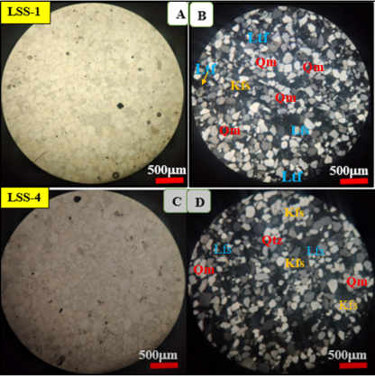
A total of fourteen samples representative rock samples were collected from different lithological units identified during field mapping and among them, eight best representative samples (LSS-1, LSS-2, LSS-3, LSS-4, LSS-4, LSS-5, LSS-6, LSS-7, and LSS-9) were selected for petrographic analysis to thin section preparation. Petrographic analysis was performed using a thin-section polarizing microscope to examine the mineralogical composition, texture, and structures of the rocks.
4. Result
4.1. Geology and Petrography of Lemi Area
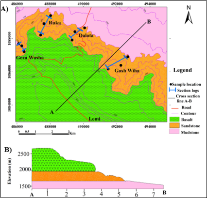
The geology of the Lemi area is characterized by clastic sedimentary and volcanic successions which are exposed in the northern, southern, and central parts of the study area. The names of lithological units were given during the fieldwork and modified as appropriate from petrographic analysis based on mineralogical compositions and associated microstructural descriptions. Thus, based on field observation and petrographic description, the study area is generally grouped into two mappable Mesozoic clastic units (Mudstone and Sandstone units) and Cenozoic volcanic rocks (Basaltic rock) (Figure 3). Finally represented on the geological map of the study area at the scale of 1:25,000 and its cross section is also prepared to reveal the vertical stratigraphic successions of the unit (Figure 3). The detailed geological character of each unit is discussed below.
4.1.1. Mudstone
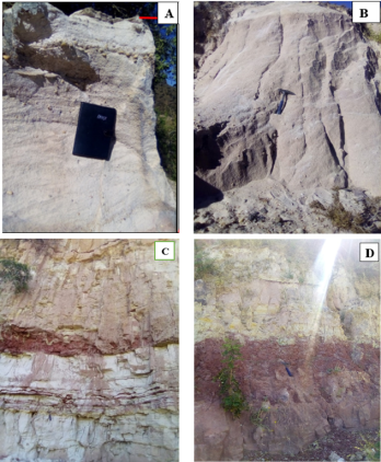
The mudstone unit exposed in the northern part of the study area and separated from the overlying sandstone by gradational contact at an elevation of about 1700m (Figure 4D). This unit is characterized by easily friable, hard compacted layer and thin beds of lamination. Mudstone creates gentle sloped morphologic features and is mainly exposed along roads and streams. It is composed of gray shale, yellowish to white siltstone, and red to light yellow mudstone (Figure 4D) And also shows a high degree of weathering and the predominant structure is bedding and lamination.
4.1.2. The Sandstone Unit
The sandstone is observed in the central part of the study area. According to their grain size, color, and composition, the sandstone unit is classified into three main categories such as coarse grain sandstone, medium grain sandstone, and fine grain sandstone. The petrography of these sandstone units shows the mineralogy and accessory minerals of the Lemi area sandstone deposit (thin section) (Figure 8; Table 1).
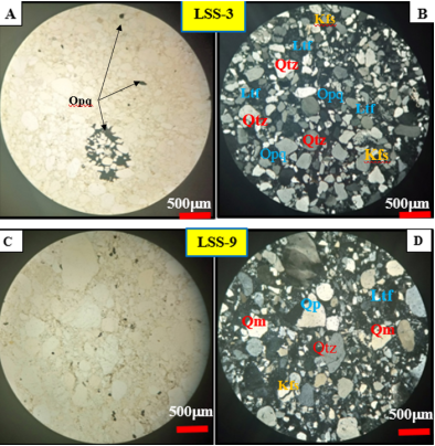
Coarse grain sandstone is characterized by bedding and cross-bedding, sub-angular, rounded to well-rounded grain shape, pebble-sized quartz clasts with a matrix of fine sand grains. The orientation of the clasts and the cross-bedding structure tell the paleocurrent direction or water flow direction during the deposition of this sandstone unit. The grains are moderately matured depending on the clay content, the grain roundness, and the sorting of the grains. The color varies from reddish, to light gray, and white depending on the impurities of iron oxide and other impurities (Figure 4A). A microscopic study of coarse sandstone rock shows an average composition of quartz (95 %), feldspar (1%), and lithic fragments (4 %. The quartz grains can be monocrystalline, or polycrystalline. Polycrystalline quartz shows undulate extinction which indicates the strain in the crystal lattices due to deformation (Figure 5A to D). Both monocrystalline and polycrystalline quartz grain shows angular to well-rounded grain shapes. Poorly to moderately well sorted.
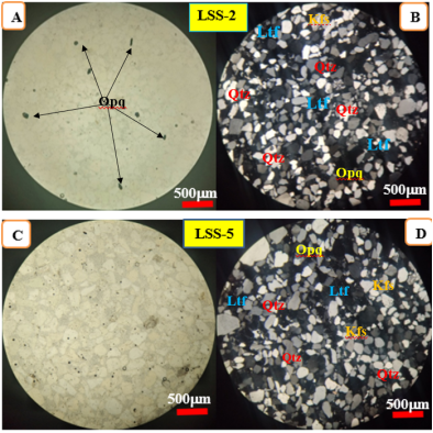
Medium-grained sandstone is characterized by cliff-forming topography and primary structures are bedding, cross-bedding, and massive structure. It shows sub-rounded to well-rounded clasts. The grains are sub-mature depending on the grain roundness and sorting of the grains. The color varies from yellowish, to light grey, and white (Figure 4B). A microscopic study of medium-grained sandstone rock shows an average composition of quartz (95 %), feldspar (1%), and lithic fragments (4 %). The feldspars grains show a dusty appearance due to alteration. Dominantly the quartz grains show both clasts supported and matrix-supported (Figure 6A to D).
Fine-grained sandstone is characterized by interbedded reddish mudstone within the layer, easily friable, and primary structures are bedding, cross-bedding, and ripple marks. It shows a rounded to well-rounded grain shape. The grain is characterized as dominantly fine, well-sorted, and matured. The color varies from light grey and white (Figure 4C). A microscopic study of fine-grained sandstone rock shows an average of quartz (96 %), feldspar (1%), and lithic fragments (3 %). The quartz grains are rounded to well rounded, matured, and well sorted (Figure 7A to D).
4.1.3. The Basaltic Units
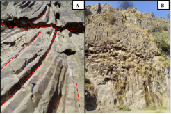
Basalt is the top stratigraphic succession that covers most parts of the study area. It has a dark fresh and dark brown weathered color. The upper part of the basalt weathered intensively and changed into black cotton soil, whereas the lower section is relatively fresh. This unit often exhibits aphanitic, porphyritic, and vesicular textures. It shows phenocrysts of olivine and pyroxene. Secondary structures in basalt are columnar joints (Figure 9A & B). Also, exposed along the main road, vertical ridge, and gentle slope area.
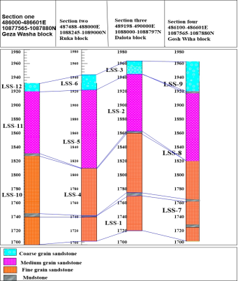
4.2. Stratigraphy of Sandstones in Lemi Area
The stratigraphy of the sedimentary stratigraphy section in the Lemi area contains (from bottom to top) fine sandstone to coarse sandstone with intercalations of thinly bedded mudstone (Figure 11). The sedimentary succession is overlaid by the extensive basaltic unit. This stratigraphy succession reveals a geological history of volcanic activity and sedimentation in the Lemi area. Stratigraphically, the Lemi area sedimentary stratigraphy section is grouped into four blocks, namely, Geza Washa block (section one), Ruka block (section two), Dalota block (section three), and Gosh Wiha block (Section four) (Figure 11). The Sandstone unit in the study covers an estimated average thickness is 237 meters with intercalations of thinly bedded mudstone in fine-grained sandstone.
Coarse grain sandstone is a sub-section that has an average thickness of 23 meters that overlain by tertiary basalt. The thickness of coarse sandstone units in each block varies from 10 meters to 40 meters such as from Geza Washa block (10 m), Ruka block (25 m), Dalota block (18 m), and Gosh Wiha block (40 m) (Figure 10C).
The Medium-grain sandstone sub-section has an average thickness of 90 meters. The thickness variation of medium grain sandstone is from the Geza Washa block (88 m), Ruka block (110 m), Dalota block (81 m), and Gosh Wiha block (79 m) (Figure 10B).
Fine grain sandstone unit is exposed at the bottom part as compared to coarse grain and medium grain sandstone units. The average thickness of this sandstone unit is 115 m. The thickness variation of fine grain sandstone is from the Geza Washa block (121 m) Ruka block (105 m), Dalota block (136m), and Gosh Wiha block (95m) (Figure 10A). By considering its sedimentary facies and stratigraphic sequence, the mudstone unit of the study area occur as intercalations with fine-grained sandstone which correlated with the regional Mugher Mudstone formation. Because it has similar lithological character, texture, color, structure, and stratigraphic position.
5. Discussion
Lithostratigraphic Framework: from the stratigraphic analysis, the study area has four stratigraphic section blocks including Geza washa, Dalota, Ruka, and Gosh Wiha. These section blocks show that the coarsening upward sequence (bottom to top) could indicate a gradual increase in the grain size of sedimentary layers. This suggests the depositional environment for Lemi Sandstone is inferred to range from deep marine or quieter conditions to shallower water or more energetic depositional conditions. Assefa
[4]
Assefa, G. (1981). Gohatsion Formation: A new Lias-Malm lithostratigraphic unit from the Abay River basin, Ethiopia. Geoscience Journal, 2(1), 63-88.
suggested a depositional environment of Debre Libanos sandstone is characterized by a coarsening upward sequence that could be associated with the progradation of a delta, a beach environment, or even a fluvial succession. The lithostratigraphy of the Lemi area is directly correlated to the regional Debre Libanos sandstone formation.
Petrographic Analysis: from detailed field investigation, geological mapping, and petrographic analysis of the mineral composition, texture, and diagenetic features the study area is mainly exposed to the sedimentary rocks. Based on this analysis, the sandstone unit ranges in grain size from coarse to fine-grained, is highly rich in quartz, and has a small amount of feldspar and lithic fragments, well-sorted and well-rounded gain shape, and cross-bedding structure. This indicates that they are classified as clastic sedimentary facies and river (more energetic) depositional environments. Tectonically, both lithostratigraphic and petrographic analysis help us understand how sea levels changed over time and how sedimentary environments shifted. After the deposition of sedimentary layers, due to main central Ethiopian rifting and continental flooding of basalts the volcanic rocks are exposed over sedimentary rock.
6. Conclusion
In conclusion, the lithostratigraphy and petrography study of the Mesozoic sedimentary rocks in the Lemi area, North Shewa, Central Ethiopia, have provided valuable insights into the geological history and paleoenvironmental conditions of the region. The identification and characterization of lithostratigraphic units, along with detailed petrographic analysis, have enhanced our understanding of the sedimentary succession in the study area. The results of the study have revealed the presence of distinct lithostratigraphic units with varying mineral compositions, textures, and diagenetic features with 237 m in composite thickness, suggesting different depositional environments and sediment sources. The interpretation of sedimentary facies and structures has allowed for the reconstruction of paleoenvironmental conditions, indicating a dynamic tectonic setting with evolving depositional environments during the Mesozoic. The findings of this study not only contribute to the local geological understanding of the Lemi area but also have broader implications for regional stratigraphy, paleogeography, and tectonic history in Central Ethiopia. The correlation of lithostratigraphic units and petrographic characteristics with Debre Libanos formations in the region. While this study has provided significant insights into the Mesozoic sedimentary rocks of the Lemi area, it is important to acknowledge its limitations, such as the need for additional geochemical analysis, and geochronology studies for further research.
Abbreviations
BMI
Body Mass Index
LSS
Lemi Sand Stone
PPL
Plane Polarized Light
XPL
Cross-Polarized Light
Acknowledgments
We would like to acknowledge the Ministry of Education of Ethiopia for the opportunities to study this research and Addis Science and Technology for helping their Petrological laboratories. We would like to thank Dr. Tesfaye Demissie for his guidance, advice, constructive comments, positive criticism, supportive materials, and suggestions support from starting up to the final this research work. We run out of words to express our deepest thanks to Ensaro Woreda, Lemi town administrative office and communities, and the resident people of the area for their respectful acceptance and advice during fieldwork.
Data presented in this study are available upon request from the corresponding author.
Declarations Ethics Approval
The authors declare that the contents of the manuscript on this research study are prepared was carried out under the ethical guidelines and regulations of the Journal. The study does not involve the participation of humans and/or animals because of the Consent to participate and for publication Not applicable for this study.
Figure 1. Regional geological map of Blue Nile Basin (After Enkurie,
[10]
Enkurie, D. (2010). Adigrat Sandstone in Northern and Central Ethiopia: Stratigraphy, Facies, Depositional Environments and Palynology (PhD Thesis). Technical University of Berlin.
[10]
).
Table 1. Mineralogy of Lemi sand deposit (thin section).
Figure 4. Field photograph of sandstone units and Mudstone. Coarse-grained sandstone (A), Medium grain sandstone (B), Fine-grained sandstone (C), and Mudstone unit with reddish to gray color friable and compacted layer, weathered yellowish color mudstone interbedded with a thin layer of laminated shale (D).
Figure 5. Photomicrograph of coarse-grain sandstone. A and C in PPL and Band D in XPL, A) sample number LSS-3 and C) sample number LSS-9, D) Polycrystalline and monocrystalline quartz (all the images taken in 4x magnification power and Scale bar is 500 <i></i>m). (Qm: Mono-crystalline quartz, Qp: Poly-crystalline quartz, Kfs: k-feldspar, Opq: opaque mineral.
Figure 6. Photomicrograph of medium grain sandstone. A and C in PPL and B and D in XPL, A) sample number LSS-2 and C) sample number LSS-5 (all the images taken in 4x magnification power and Scale bar is 500 m) (Qtz: Quartz, Kfs: k-feldspar, Opq: opaque, Ltf: Lithic fragment).
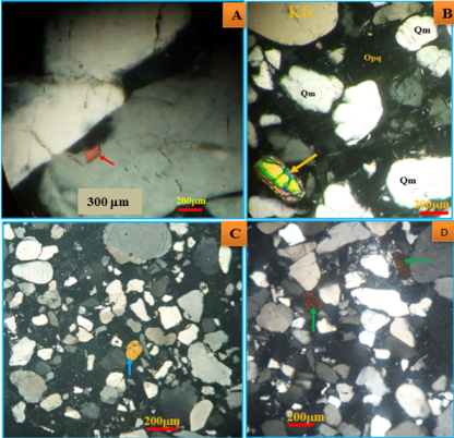
Figure 8. Photomicrograph of accessory minerals in sandstone unite; the red arrow shows rutile (A); yellow arrow shows accessory mineral of zircon (B); blue arrow rounded tourmaline mineral; (C) tourmaline mineral and green arrow shows biotite mineral (D).
Figure 11. The overall stratigraphic section of the Lemi area and Block correlation of coarse grain sandstone, medium grain sandstone, and fine grain sandstone from different locations and blocks.
References
[1]
Abate, B., Koeberl, C., Buchanan, P. C., & Körner, W. (1998). Petrography and geochemistry of basaltic and rhyodacitic rocks from Lake Tana and the Gimjabet-Kosober areas (North Central Ethiopia). Journal of African Earth Sciences, 26(1), 119–134.
Alemu, T. (2021). Tectonic Evolution of the Pan-African Belt in Western Ethiopia, Southern Arabian-Nubian Shield. In: Hamimi, Z., Fowler, AR., Liégeois, JP., Collins, A., Abdelsalam, M. G., Abd EI-Wahed, M. (eds) The Geology of the Arabian-Nubian Shield. Regional Geology Reviews. Springer, Cham.
Assefa, G. (1991). Lithostratigraphy and environment of deposition of the Late Jurassic - Early Cretaceous sequence of the central part of Northwestern Plateau, Ethiopia. Neues Jahrbuch Für Geologie Und Paläontologie - Abhandlungen, 182(3), 255–284.
Berhe, S. M., Desta, B., Nicoletti, M., & Teferra, M. (1987). Geology, geochronology, and geodynamic implications of the Cenozoic magmatic province in W and SE Ethiopia. Journal - Geological Society (London), 144(2), 213–226.
Bosellini, A. (1989). The continental margins of Somalia: Their structural evolution and sequence stratigraphy. Mem. Sci. Geol. 41, 373-458.
[9]
Ebinger, C. J., Becker, T., & Ring, U. (1993). Tectonic controls on rift basin morphology: evolution of the Northern Malawi (Nyasa) Rift Tectonic Controls on Rift Basin Morphology’ Evolution of the Northern Malawi (Nyasa) Rift. November 2016.
Enkurie, D. (2010). Adigrat Sandstone in Northern and Central Ethiopia: Stratigraphy, Facies, Depositional Environments and Palynology (PhD Thesis). Technical University of Berlin.
[11]
Gani, N., Abdelsalam., G., Gera, M., & Gani, R. (2008). Stratigraphic and Structural Evolution of the Blue Nile Basin, Northwestern Ethiopian Plateau. Geological Journal, 44(1), 30–56.
Getaneh, W. (2002). Geochemistry Provenance and Depositional Tectonic Setting of the Adigrat Sandstone Northern Ethiopia. Journal of African Earth Sciences, 35(2), 185-198.
Getaneh, W., & Atnafu, B. (2020). Journal of African Earth Sciences Geochemistry and lithostratigraphy of the mugher mudstone : Insights into the late Jurassic-early cretaceous clastic sedimentation in Ethiopia and its surroundings. Journal of African Earth Sciences, 164(August 2019), 103770.
Kazmin, V., Shifferaw, A., & Balcha, T. (1978). The Ethiopian basement: Stratigraphy and possible manner of evolution. Geologische Rund., 67(2), 531–546.
Mohammedyasin, M. S., & Wudie, G. (2018). The provenance of the cretaceous Debre Libanos Sandstone in the Blue Nile Basin, Ethiopia: Evidence from petrography and geochemistry. Sedimentary Geology.
Woldemichael, B. W., Kimura, JI., Dunkley, D. J. et al. SHRIMP. ((2010). U–Pb zircon geochronology and Sr–Nd isotopic systematic of the Neoproterozoic Ghimbi-Nedjo mafic to intermediate intrusions of Western Ethiopia: a record of passive margin magmatism at 855 Ma? Int J Earth Sci (Geol Rundsch) 99, 1773–1790.
Wolfenden, E., Ebinger, C., Yirgu, G., Deino, A., & Ayalew, D. (2004). Evolution of the Northern Main Ethiopian Rift: Birth of a Triple Junction. Earth and Planetary Science Letters, 224(1-2), 213-228.
Wuletaw, A., Mihret, B. (2024). Lithostratigraphy and Petrography of Mesozoic Sedimentary Rocks of Lemi Area, North Shewa, Central Ethiopia. Earth Sciences, 13(4), 116-126. https://doi.org/10.11648/j.earth.20241304.11
Wuletaw, A.; Mihret, B. Lithostratigraphy and Petrography of Mesozoic Sedimentary Rocks of Lemi Area, North Shewa, Central Ethiopia. Earth Sci.2024, 13(4), 116-126. doi: 10.11648/j.earth.20241304.11
Wuletaw A, Mihret B. Lithostratigraphy and Petrography of Mesozoic Sedimentary Rocks of Lemi Area, North Shewa, Central Ethiopia. Earth Sci. 2024;13(4):116-126. doi: 10.11648/j.earth.20241304.11
@article{10.11648/j.earth.20241304.11,
  author = {Ajebush Wuletaw and Bishaw Mihret},
  title = {Lithostratigraphy and Petrography of Mesozoic Sedimentary Rocks of Lemi Area, North Shewa, Central Ethiopia
},
  journal = {Earth Sciences},
  volume = {13},
  number = {4},
  pages = {116-126},
  doi = {10.11648/j.earth.20241304.11},
  url = {https://doi.org/10.11648/j.earth.20241304.11},
  eprint = {https://article.sciencepublishinggroup.com/pdf/10.11648.j.earth.20241304.11},
  abstract = {The Mesozoic sedimentary basins in Ethiopia, particularly the Central Ethiopia, and Blue Nile Basin within the central main Ethiopian rift region are characterized by a diverse range of volcano-sedimentary rocks dominated by sedimentary sequences. The lithostratigraphy and petrology of Mesozoic sedimentary rocks of Lemi area, North Shewa, in Central Ethiopia within the Blue Nile basin, is described based on detailed field observations, lithostratigraphic analysis, petrographic examinations. The lithological units identified during fieldwork include Mudstone, Sandstone, and Basaltic rock formations. The sandstone unit in the study covers an estimated average thickness is 237 meters with intercalations of thinly bedded mudstone. The average thickness of each sandstone units (coarse (23 meters), medium (90 meters) and fine-grained (115 meters) sandstone unit) are varying from place to place within the study area. The stratigraphic section logs in four each block (Geza Washa, Dalota, Ruka, and Gosh Wiha) shows coarsening upward indicating the depositional environment transition from deep marine to the fluvial environment. The results of the study reveal the geological history and paleoenvironmental conditions of the Mesozoic sedimentary rocks in the Lemi area. This study contributes to our understanding of the geological processes that have influenced the formation of the Lemi area and provides valuable interpretations of regional geology.
},
 year = {2024}
}
TY  - JOUR
T1  - Lithostratigraphy and Petrography of Mesozoic Sedimentary Rocks of Lemi Area, North Shewa, Central Ethiopia

AU  - Ajebush Wuletaw
AU  - Bishaw Mihret
Y1  - 2024/07/04
PY  - 2024
N1  - https://doi.org/10.11648/j.earth.20241304.11
DO  - 10.11648/j.earth.20241304.11
T2  - Earth Sciences
JF  - Earth Sciences
JO  - Earth Sciences
SP  - 116
EP  - 126
PB  - Science Publishing Group
SN  - 2328-5982
UR  - https://doi.org/10.11648/j.earth.20241304.11
AB  - The Mesozoic sedimentary basins in Ethiopia, particularly the Central Ethiopia, and Blue Nile Basin within the central main Ethiopian rift region are characterized by a diverse range of volcano-sedimentary rocks dominated by sedimentary sequences. The lithostratigraphy and petrology of Mesozoic sedimentary rocks of Lemi area, North Shewa, in Central Ethiopia within the Blue Nile basin, is described based on detailed field observations, lithostratigraphic analysis, petrographic examinations. The lithological units identified during fieldwork include Mudstone, Sandstone, and Basaltic rock formations. The sandstone unit in the study covers an estimated average thickness is 237 meters with intercalations of thinly bedded mudstone. The average thickness of each sandstone units (coarse (23 meters), medium (90 meters) and fine-grained (115 meters) sandstone unit) are varying from place to place within the study area. The stratigraphic section logs in four each block (Geza Washa, Dalota, Ruka, and Gosh Wiha) shows coarsening upward indicating the depositional environment transition from deep marine to the fluvial environment. The results of the study reveal the geological history and paleoenvironmental conditions of the Mesozoic sedimentary rocks in the Lemi area. This study contributes to our understanding of the geological processes that have influenced the formation of the Lemi area and provides valuable interpretations of regional geology.

VL  - 13
IS  - 4
ER  -