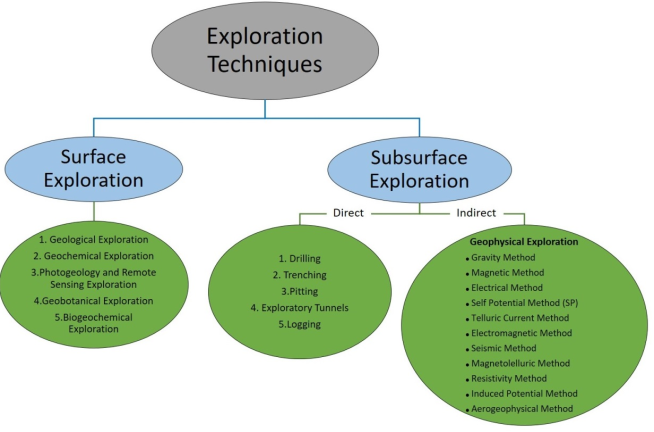
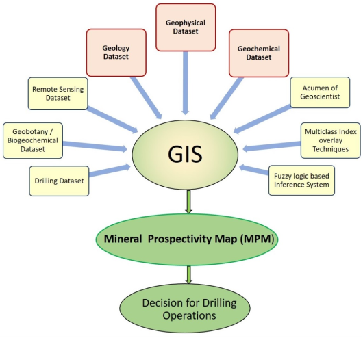
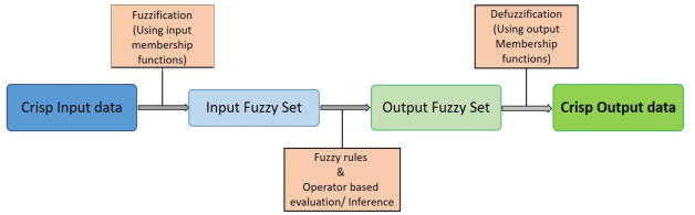
In every sphere and utility aspects of human life, there is need of metals and construction materials. Minerals which are below the near subsurface is almost explored on the basis of direct geospatial evidences. There is high demand of metals and other materials which are mined below the surface of earth In the current landscape, there's a demand for faster and more precise exploration strategies, particularly emphasizing Greenfield exploration and deep-seated mineralization. This paper conducts a comprehensive review of existing methodologies for integrating multi-geoscience datasets aimed at mineral prognostication, with a focus on identifying the most precise and authentic Artificial Intelligence (AI) - based data integration techniques. Additionally, it offers insights into the current status of mineral exploration in India and the global evolution of data integration practices. Several types of geoscientific datasets i.e. geological, geophysical, geochemical and geospectral data have to be organized in geospatial domain for meaningful mineral exploration outcome. These datasets have been processed to extract exploratory indicator layers for data integration are called Mineral Prospectivity Mapping (MPM). Indeed, MPM is a multiple criterion decision making (MCDM) task which provide a predictive model for categorizing of sought areas in terms of ore mineralization. There after based upon Geological factors i.e. lithology, structure, shear & fault zones, alteration zones etc. of sought mineralized area, selection of drilling parameters (depth, angle, level, type, rpm, feed) is done for resource assessment. Literature survey suggests that minerals exploration by integrated approach on the basis of these datasets is still poorly performed. It has been gathered that knowledge-driven data integration using Fuzzy Gamma Operator and Multiclass Index Overlay method is best suited for mineral exploration. In past, few researchers of other countries have exploited data integration approach with encouraging results. Despite the abundance of data available in India, this approach has not been utilized very successfully and no standard protocols exist even for decision making for drilling operation. Thus, it's evident that employing the Fuzzy Inference System (FIS) algorithm, particularly utilizing the Fuzzy Gamma Operator and Multiclass Index Overlay integration method, remains underutilized in designing standardized operating procedures (SOP) for mineral exploration in India and decision-making for drilling operations. This approach holds promise for minimizing time lag and optimizing resources such as manpower, instruments, and finances.
| Published in | Earth Sciences (Volume 13, Issue 4) |
| DOI | 10.11648/j.earth.20241304.12 |
| Page(s) | 127-140 |
| Creative Commons |
This is an Open Access article, distributed under the terms of the Creative Commons Attribution 4.0 International License (http://creativecommons.org/licenses/by/4.0/), which permits unrestricted use, distribution and reproduction in any medium or format, provided the original work is properly cited. |
| Copyright |
Copyright © The Author(s), 2024. Published by Science Publishing Group |
Mineral Exploration, Integration, Geoscience Datasets, Mineral Prospectivity Mapping, Fuzzy Inference System, Fuzzy Gamma Operator, Mineral Exploration in India, Knowledge-Driven Technique, Data–Driven Technique
| [1] | Abedi, M., Torabi, S. A., Norouzi, G. H., & Hamzeh, M. (2012). ELECTRE III: A knowledge-driven method for integration of geophysical data with geological and geochemical data in mineral prospectivity mapping: Journal of applied geophysics, v87, pp9-18. |
| [2] | Abedi, M., Norouzi, G. H., & Bahroudi, A. (2012). Support vector machine for multi-classification of mineral prospectivity areas: Computers & Geosciences, v46, pp272-283. |
| [3] | Abedi, M., & Norouzi, G. H. (2012). Integration of various geophysical data with geological and geochemical data to determine additional drilling for copper exploration: Journal of Applied Geophysics, v83, pp35-45. |
| [4] | Abedi, M., Norouzi, G. H., & Fathianpour, N. (2013). Fuzzy outranking approach: a knowledge-driven method for mineral prospectivity mapping. International Journal of Applied Earth Observation and Geoinformation, 21, 556-567. |
| [5] | Agterberg, F. P. (1989). Systematic approach to dealing with uncertainty of geoscience information in mineral exploration: In Proceedings of the 21st APCOM Symposium, Las Vegas, USA, 1989, pp. 165-178. |
| [6] | Agterberg, F. P., Bonham-Carter, G. F., & Wright, D. F. (1990). Statistical pattern integration for mineral exploration. In Computer applications in resource estimation, pp. 1-21. Pergamon. |
| [7] | An, P., Moon, W. M., & Rencz, A. (1991). Application of fuzzy set theory for integration of geological, geophysical and remote sensing data: Canadian Journal of Exploration Geophysics, v27(1), pp1-11. |
| [8] | An, P., Moon, W. M., & Bonham-Carter, G. F. (1992). On knowledge-based approach of integrating remote sensing, geophysical and geological information: In [Proceedings] IGARSS'92 International Geoscience and Remote Sensing Symposium, v 1, pp 34-38, IEEE. |
| [9] | An, P., Moon, W. M., & Bonham-Carter, G. F. (1994). An object-oriented knowledge representation structure for exploration data integration: Nonrenewable Resources, v3, pp132-145. |
| [10] | Assocham report (2022): Indian Mineral & Mining Sector- Steps towards Atma nirbhar Bharat. Available from: |
| [11] | Barak, S., Bahroudi, A., & Jozanikohan, G. (2018). Exploration of Kahang porphyry copper deposit using advanced integration of geological, remote sensing, geochemical, and magnetics data: Journal of Mining and Environment, v9(1), pp19-39. |
| [12] | Barak, S., Bahroudi, A., & Jozanikohan, G. (2018). The use of fuzzy inference system in the integration of copper exploration layers in Neysian: Journal of Mining Engineering, v13(38), pp97-112. |
| [13] | Barak, S., Abedi, M., & Bahroudi, A. (2020). A knowledge-guided fuzzy inference approach for integrating geophysics, geochemistry, and geology data in a deposit-scale porphyry copper targeting, Saveh, Iran: Bollettino di Geofisica Teorica ed Applicata, 61(2). |
| [14] | Barak, S., Imamalipour, A., Abedi, M., Bahroudi, A., & Khalifani, F. M. (2021). Comprehensive modeling of mineral potential mapping by integration of multiset geosciences data: Geochemistry, v81(4), pp125824. |
| [15] | Barnett, C. T., & Williams, P. M. (2005). Mineral exploration using modern data mining techniques (Book chapter), Special publication of the Society of economic geologists, v12, pp295-310. |
| [16] | Behera, S., & Panigrahi, M. K. (2022). Gold prospectivity mapping and exploration targeting in Hutti-Maski schist belt, India: Synergistic application of Weights-of-Evidence (WOE), Fuzzy Logic (FL) and hybrid (WOE-FL) models: Journal of Geochemical Exploration, 235, 106963. |
| [17] | Boadi, B., Raju, P. S., & Wemegah, D. D. (2022). Analysing multi-index overlay and fuzzy logic models for lode-gold prospectivity mapping in the Ahafo gold district–Southwestern Ghana: Ore Geology Reviews, 148, 105059. |
| [18] | Bonham-Carter, G. F., Agterberg, F. P., & Wright, D. F. (1989). Integration of geological datasets for gold exploration in Nova Scotia: Digital geologic and geographic information systems, v10, pp15-23. |
| [19] | Bonham-Carter, G. F. (1989). Integrating Geological Datasets with a Raster-Based Geographic Information System: Digital Geologic and Geographic Information Systems (a book), v10, pp1-13. |
| [20] | Bonham-Carter, G. F., & Agterberg, F. P. (1990). Application of a microcomputer-based geographic information system to mineral-potential mapping: In Microcomputer applications in Geology v2, pp. 49-74, Pergamon. |
| [21] | Bonham-Carter, G. F. (1994). Geographic information systems for geoscientists-modeling with GIS: Computer methods in the geoscientists, v 13, p398. |
| [22] | Bonham-Carter, G. F., & Agterberg, F. P. (1999). Arc-WofE: a GIS tool for statistical integration of mineral exploration datasets. Bull Int Stat Inst, 52, 497-500. |
| [23] | Bougrain, L., Gonzalez, M., Bouchot, V., Cassard, D., Lips, A. L., Alexandre, F., & Stein, G. (2003). Knowledge recovery for continental-scale mineral exploration by neural networks. Natural Resources Research, 12, 173-181. |
| [24] | Brown, W.M., Gedeon, T.D., Groves, D.I. and Barnes, R.G., (2000). Artificial neural networks: a new method for mineral prospectivity mapping: Australian journal of earth sciences, v47(4), pp. 757-770. |
| [25] | Brown, W., Groves, D., & Gedeon, T. (2003). Use of fuzzy membership input layers to combine subjective geological knowledge and empirical data in a neural network method for mineral-potential mapping: Natural Resources Research, v12, pp183-200. |
| [26] | Burkin, J. N., Lindsay, M. D., Occhipinti, S. A., & Holden, E. J. (2019). Incorporating conceptual and interpretation uncertainty to mineral prospectivity modelling. Geoscience Frontiers, 10(4),1383-1396. |
| [27] | Carranza, E. J. M., Mangaoang, J. C., & Hale, M. (1999). Application of mineral exploration models and GIS to generate mineral potential maps as input for optimum land-use planning in the Philippines: Natural Resources Research, v8(2), pp165-173. |
| [28] | Carranza, E. J. M., & Hale, M. (2001). Logistic regression for geologically constrained mapping of gold potential, Baguio district, Philippines. Exploration and Mining Geology, 10(3), 165-175. |
| [29] | Carranza, E. J. M., & Hale, M. (2002). Wildcat mapping of gold potential, Baguio district, Philippines. Applied Earth Science, 111(2), 100-105. |
| [30] | Carranza, E.J.M. (2002). Geologically-constrained Mineral Potential Mapping (Examples from Phillippines): ITC Publication No. 86, International Institute for Aerospace survey and Earth Sciences(ITC), The Netherlands. |
| [31] | Carranza, E. J. M., & Hale, M. (2002). Where are porphyry copper deposits spatially localized? A case study in Benguet province, Philippines: Natural Resources Research, v11, pp45-59. |
| [32] | Carranza, E. J. M., & Hale, M. (2002). Weights of Evidence Modeling with Small Number of Deposits to Map Mineral Prospectivity, Abra area, Philippines. Deposits and Geoenvironmental Models For Resources Exploitation and Environmental Security II, 59. |
| [33] | Carranza, E. J. M., Woldai, T., & Chikambwe, E. M. (2005). Application of data-driven evidential belief functions to prospectivity mapping for aquamarine-bearing pegmatites, Lundazi district, Zambia: Natural Resources Research, v14, pp 47-63. |
| [34] | Carranza, E. J. M., Hale, M., & Faassen, C. (2008). Selection of coherent deposit-type locations and their application in data-driven mineral prospectivity mapping: Ore geology reviews, v33(3-4), pp536-558. |
| [35] | Carranza, E. J. M., & Hale, M. (2009). Handbook of exploration and environmental geochemistry. Chapter, 7, Knowledge-driven modelling of mineral prospectivity, v11, pp 189-247. |
| [36] | Carranza E. J. M. (2009). Handbook of Exploration and Environment Geochemistry, Chapter 8: Data-Driven Modeling of Mineral Prospectivity, v11, pp 249-310. |
| [37] | Carranza, E. J. M. (2010). Mapping of anomalies in continuous and discrete fields of stream sediment geochemical landscapes: Geochemistry, v10(2), pp171. |
| [38] | Carranza, E. J. M. (2010). Improved wildcat modelling of mineral prospectivity. Resource geology, 60(2), 129-149. |
| [39] | Chung, C. J. F., & Moon, W. M. (1991). Combination rules of spatial geoscience data for mineral exploration: Geoinformatics, v2(2), pp159-169. |
| [40] | Moon, W. M., Chung, C. J. F., & An, P. (1991). Representation and integration of geological, geophysical and remote sensing data. Geoinformatics, 2(2), 177-182. |
| [41] | Derakhshani, R., & Mehrabi, A. (2009). Geologically-constrained fuzzy mapping of porphyry copper mineralization potential, Meiduk district, Iran: Trends in Applied Sciences Research, v4/4, pp 229-40. |
| [42] | Ebadi, S., Valadanzoej, J., & Vafacinezhad, A. (2001). Evaluation of indexing Overlay. Fuzzy Logic and Genetic Algorithm Method for Industrial Estate Site Selection in GIS Environment, Tehran, Iran. |
| [43] | Esmailzadeh, M., Imamalipour, A., & Aliyari, F. (2022). Application of Fuzzy Gamma Operator to Generate Mineral Prospectivity Mapping for Cu-Mo Porphyry Deposits (Case Study: Kighal-Bourmolk Area, Northwestern Iran): Journal of Mining and Environment, v13(1), pp129-153. |
| [44] | Garrett, S., Griesbach, S., Johnson, D., Jones, D., Lo, M., Orr, W., & Sword, C. (1997). Earth model synthesis. First break, 15(1). P 13-22. |
| [45] | Harris, D., & Pan, G. (1999). Mineral favorability mapping: a comparison of artificial neural networks, logistic regression, and discriminant analysis: Natural Resources Research, v8, pp 93-109. |
| [46] | Harris, J. R., Wilkinson, L., & Grunsky, E. C. (2000). Effective use and interpretation of lithogeochemical data in regional mineral exploration programs: application of Geographic Information Systems (GIS) technology: Ore Geology Reviews, v16(3-4), pp107-143. |
| [47] | Harris, D., Zurcher, L., Stanley, M., Marlow, J., & Pan, G. (2003). A comparative analysis of favorability mappings by weights of evidence, probabilistic neural networks, discriminant analysis, and logistic regression. Natural Resources Research, 12, 241-255. |
| [48] | Harris, J. R., Grunsky, E., Behnia, P., & Corrigan, D. (2015). Data-and knowledge-driven mineral prospectivity maps for Canada's North: Ore Geology Reviews, v71, pp788-803. |
| [49] | Kemp, L. D., Bonham-Carter, G. F., Raines, G. L., & Looney, C. G. (2001). Arc-SDM: ArcView Extension for Spatial Data Modeling Using Weights of Evidence. Logistic Regression, Fuzzy Logic and Neural Network Analysis. |
| [50] | Kumar, Pramod, & Pandey, Pradeep (2022). Mineral Exploration Scenario in India: Prospect, Promise and Policy Reforms: Journal of the Geological Society of India, v98(8), pp1178-1181. |
| [51] | Liu, Y., Cheng, Q., Xia, Q., & Wang, X. (2014). Mineral potential mapping for tungsten polymetallic deposits in the Nanling metallogenic belt, South China: Journal of Earth Science, v25, pp689-700. |
| [52] | Lunden, B., Wang, G., & Wester, K. (2001). A GIS based analysis of data from Landsat TM, airborne geophysical measurements, and digital maps for geological remote sensing in the Stockholm region, Sweden: International Journal of Remote Sensing, v22(4), pp517-532. |
| [53] | Ma, Y., Zhao, J., Sui, Y., Liao, S., & Zhang, Z. (2020). Application of knowledge-driven methods for mineral prospectivity mapping of polymetallic sulfide deposits in the southwest Indian ridge between 46 and 52 E: Minerals, v10(11), pp970. |
| [54] | McGaughey, W. J., & Vallee, M. A. (1998). Integrating geology and borehole geophysics in a common earth model for improved three-dimensional delineation of mineral deposits. Exploration and Mining Geology, 7(1-2), 51-62. GeoRef, Copyright 2004, American Geological Institute. |
| [55] | Ministry of Mines, Govt. of India (2023). National Mineral Scenario report. Availalbe from: |
| [56] |
Ministry of Mines, Govt. of India, (June 2023). Report of the committee on Critical Minerals for India. Available from:
https://mines.gov.in/admin/storage/app/uploads/649d4212cceb01688027666.pdf |
| [57] | Mohammadi, F., Tangestani, M. H., & Tayebi, M. H. (2022). Prospectivity mapping of orogenic lode gold deposits using fuzzy models: a case study of Saqqez area, NW of Iran: Earth Science Informatics, v15(4), pp2387-2404. |
| [58] | Moon, W. M. (1990). Integration of geophysical and geological data using evidential belief function. IEEE Transactions on Geoscience and Remote Sensing, 28(4), 711-720. |
| [59] | Nykänen, V., & Salmirinne, H. (2007). Prospectivity analysis of gold using regional geophysical and geochemical data from the Central Lapland Greenstone Belt, Finland: Geological Survey of Finland, v44, pp 251-269. |
| [60] | Nykänen, V., Lahti, I., Niiranen, T., & Korhonen, K. (2015). Receiver operating characteristics (ROC) as validation tool for prospectivity models—A magmatic Ni–Cu case study from the Central Lapland Greenstone Belt, Northern Finland. Ore Geology Reviews, 71, 853-860. |
| [61] | Nykänen, V., Niiranen, T., Molnár, F., Lahti, I., Korhonen, K., Cook, N., & Skyttä, P. (2017). Optimizing a knowledge-driven prospectivity model for gold deposits within Peräpohja Belt, Northern Finland. Natural Resources Research, 26, 571-584. |
| [62] | Ping, An, Moon, W. M., & Rencz, A.,(1991). Application of fuzzy set theory to integrated mineral exploration. Can. Jour. Of explo. Geophysics, v27no1 p 1-11. |
| [63] | Porwal, A., Carranza, E. J. M., & Hale, M. (2003). Artificial neural networks for mineral-potential mapping: a case study from Aravalli Province, Western India. Natural resources research, 12, 155-171. |
| [64] | Porwal, A., Carranza, E. J. M., & Hale, M. (2004). A hybrid neuro-fuzzy model for mineral potential mapping. Mathematical geology, 36(7), 803-826. |
| [65] | Porwal, A., Carranza, E. J. M., & Hale, M. (2006). Bayesian network classifiers for mineral potential mapping. Computers & Geosciences, 32(1), 1-16. |
| [66] | Porwal, A., Das, R.D., Chaudhary, B., Gonzalez-Alvarez, I. and Kreuzer, O. (2015). Fuzzy inference systems for prospectivity modeling of mineral systems and a case-study for prospectivity mapping of surficial Uranium in Yeelirrie Area, Western Australia: Ore Geol. Rev., v.71, pp.839-852. |
| [67] | Poulton, M. M., Sternberg, B. K., & Glass, C. E. (1992). Location of subsurface targets in geophysical data using neural networks. Geophysics, 57(12), 1534-1544. |
| [68] | Raines, G. L. (1999). Evaluation of weights of evidence to predict epithermal-gold deposits in the Great Basin of the Western United States. Natural Resources Research, 8(4), 257-276. |
| [69] | Saadat, S. (2017). Comparison of various knowledge-driven and logistic-based mineral prospectivity methods to generate Cu and Au exploration targets Case study: Feyz-Abad area (North of Lut block, NE Iran): Journal of Mining and Environment, v8(4), pp611-629. |
| [70] | Sabbaghi, H., & Tabatabaei, S. H. (2022). Application of the most competent knowledge-driven integration method for deposit-scale studies: Arabian Journal of Geosciences, v15(11), pp1057. |
| [71] | Sadeghi, B., Khalajmasoumi, M., Afzal, P., & Moarefvand, P. (2014). Discrimination of iron high potential zones at the zaghia iron ore deposit, bafq, using index overlay GIS method. Iranian Journal of Earth Sciences, 6(2), 91-98. Available on Google Scholar. |
| [72] | Singer, D. A., & Kouda, R. (1997). Use of a neural network to integrate geoscience information in the classification of mineral deposits and occurrences. In Proceedings of exploration (Vol. 97, pp. 127-134). |
| [73] | Singer, D. A., & Kouda, R. (1999). A comparison of the weights-of-evidence method and probabilistic neural networks. Natural Resources Research, 8, 287-298. |
| [74] | Singh P. K., and Jha Ranjeeta (2020): Predictive modelling for gold potential mapping with the spatial integration of geoscientific data in GIS environment for parts of Mahakoshal Group in UP, India: Indian Journal of Geosciences, v74, no-1. |
| [75] | Sun, T., Li, H., Wu, K., Chen, F., Zhu, Z., & Hu, Z. (2020). Data-driven predictive modelling of mineral prospectivity using machine learning and deep learning methods: A case study from southern Jiangxi Province, China: Minerals, v10(2), pp102. |
| [76] | Tangestani, M. H., & Moore, F. (2001). Porphyry copper potential mapping using the weights of evidence model in a GIS, northern Shahr e Babak, Iran: Australian Journal of Earth Sciences, v48(5), pp695-701. |
| [77] | Venkataraman, G., Madhavan, B. B., Ratha, D. S., Antony, J. P., Goyal, R. S., Banglani, S., & Roy, S. S. (2000). Spatial modeling for base-metal mineral exploration through integration of geological data sets: Natural Resources Research, v9(1), pp 27-42. |
| [78] | Wolfgang N. (2001). Images of the invisible-prospection methods for the documentation of threatened archaeological sites. Naturwissenschaften, 88, 13-24. |
| [79] | Yeomans, C. M., Shail, R. K., Grebby, S., Nykänen, V., Middleton, M., & Lusty, P. A. (2020). A machine learning approach to tungsten prospectivity modelling using knowledge-driven feature extraction and model confidence: Geoscience Frontiers, v11(6), pp2067-2081. |
| [80] | Zadeh, L. A. (1965). Fuzzy sets, Information and control, v8(3), pp338-353. |
| [81] | Zimmermann, H.J. (1985). Fuzzy set theory and its applications. Springer Science Buisness Media, LLC. A Book. |
| [82] | Zhang, N., & Zhou, K. (2015). Mineral prospectivity mapping with weights of evidence and fuzzy logic methods: Journal of Intelligent & Fuzzy Systems, v29(6), pp2639-2651. |
| [83] | Zuo, R., & Carranza, E. J. M. (2011). Support vector machine: A tool for mapping mineral prospectivity: Computers & Geosciences, 37(12), 1967-1975. |
APA Style
Katiyar, N., Kulshreshtha, A., Singh, P. K. (2024). A Review of Integration Techniques of Multi-Geoscience Data-Sets in Mineral Prospectivity Mapping. Earth Sciences, 13(4), 127-140. https://doi.org/10.11648/j.earth.20241304.12
ACS Style
Katiyar, N.; Kulshreshtha, A.; Singh, P. K. A Review of Integration Techniques of Multi-Geoscience Data-Sets in Mineral Prospectivity Mapping. Earth Sci. 2024, 13(4), 127-140. doi: 10.11648/j.earth.20241304.12
AMA Style
Katiyar N, Kulshreshtha A, Singh PK. A Review of Integration Techniques of Multi-Geoscience Data-Sets in Mineral Prospectivity Mapping. Earth Sci. 2024;13(4):127-140. doi: 10.11648/j.earth.20241304.12
@article{10.11648/j.earth.20241304.12,
  author = {Neelesh Katiyar and Asita Kulshreshtha and Pramod Kumar Singh},
  title = {A Review of Integration Techniques of Multi-Geoscience Data-Sets in Mineral Prospectivity Mapping
},
  journal = {Earth Sciences},
  volume = {13},
  number = {4},
  pages = {127-140},
  doi = {10.11648/j.earth.20241304.12},
  url = {https://doi.org/10.11648/j.earth.20241304.12},
  eprint = {https://article.sciencepublishinggroup.com/pdf/10.11648.j.earth.20241304.12},
  abstract = {In every sphere and utility aspects of human life, there is need of metals and construction materials. Minerals which are below the near subsurface is almost explored on the basis of direct geospatial evidences. There is high demand of metals and other materials which are mined below the surface of earth In the current landscape, there's a demand for faster and more precise exploration strategies, particularly emphasizing Greenfield exploration and deep-seated mineralization. This paper conducts a comprehensive review of existing methodologies for integrating multi-geoscience datasets aimed at mineral prognostication, with a focus on identifying the most precise and authentic Artificial Intelligence (AI) - based data integration techniques. Additionally, it offers insights into the current status of mineral exploration in India and the global evolution of data integration practices. Several types of geoscientific datasets i.e. geological, geophysical, geochemical and geospectral data have to be organized in geospatial domain for meaningful mineral exploration outcome. These datasets have been processed to extract exploratory indicator layers for data integration are called Mineral Prospectivity Mapping (MPM). Indeed, MPM is a multiple criterion decision making (MCDM) task which provide a predictive model for categorizing of sought areas in terms of ore mineralization. There after based upon Geological factors i.e. lithology, structure, shear & fault zones, alteration zones etc. of sought mineralized area, selection of drilling parameters (depth, angle, level, type, rpm, feed) is done for resource assessment. Literature survey suggests that minerals exploration by integrated approach on the basis of these datasets is still poorly performed. It has been gathered that knowledge-driven data integration using Fuzzy Gamma Operator and Multiclass Index Overlay method is best suited for mineral exploration. In past, few researchers of other countries have exploited data integration approach with encouraging results. Despite the abundance of data available in India, this approach has not been utilized very successfully and no standard protocols exist even for decision making for drilling operation. Thus, it's evident that employing the Fuzzy Inference System (FIS) algorithm, particularly utilizing the Fuzzy Gamma Operator and Multiclass Index Overlay integration method, remains underutilized in designing standardized operating procedures (SOP) for mineral exploration in India and decision-making for drilling operations. This approach holds promise for minimizing time lag and optimizing resources such as manpower, instruments, and finances.
},
 year = {2024}
}
TY  - JOUR
T1  - A Review of Integration Techniques of Multi-Geoscience Data-Sets in Mineral Prospectivity Mapping

AU  - Neelesh Katiyar
AU  - Asita Kulshreshtha
AU  - Pramod Kumar Singh
Y1  - 2024/07/09
PY  - 2024
N1  - https://doi.org/10.11648/j.earth.20241304.12
DO  - 10.11648/j.earth.20241304.12
T2  - Earth Sciences
JF  - Earth Sciences
JO  - Earth Sciences
SP  - 127
EP  - 140
PB  - Science Publishing Group
SN  - 2328-5982
UR  - https://doi.org/10.11648/j.earth.20241304.12
AB  - In every sphere and utility aspects of human life, there is need of metals and construction materials. Minerals which are below the near subsurface is almost explored on the basis of direct geospatial evidences. There is high demand of metals and other materials which are mined below the surface of earth In the current landscape, there's a demand for faster and more precise exploration strategies, particularly emphasizing Greenfield exploration and deep-seated mineralization. This paper conducts a comprehensive review of existing methodologies for integrating multi-geoscience datasets aimed at mineral prognostication, with a focus on identifying the most precise and authentic Artificial Intelligence (AI) - based data integration techniques. Additionally, it offers insights into the current status of mineral exploration in India and the global evolution of data integration practices. Several types of geoscientific datasets i.e. geological, geophysical, geochemical and geospectral data have to be organized in geospatial domain for meaningful mineral exploration outcome. These datasets have been processed to extract exploratory indicator layers for data integration are called Mineral Prospectivity Mapping (MPM). Indeed, MPM is a multiple criterion decision making (MCDM) task which provide a predictive model for categorizing of sought areas in terms of ore mineralization. There after based upon Geological factors i.e. lithology, structure, shear & fault zones, alteration zones etc. of sought mineralized area, selection of drilling parameters (depth, angle, level, type, rpm, feed) is done for resource assessment. Literature survey suggests that minerals exploration by integrated approach on the basis of these datasets is still poorly performed. It has been gathered that knowledge-driven data integration using Fuzzy Gamma Operator and Multiclass Index Overlay method is best suited for mineral exploration. In past, few researchers of other countries have exploited data integration approach with encouraging results. Despite the abundance of data available in India, this approach has not been utilized very successfully and no standard protocols exist even for decision making for drilling operation. Thus, it's evident that employing the Fuzzy Inference System (FIS) algorithm, particularly utilizing the Fuzzy Gamma Operator and Multiclass Index Overlay integration method, remains underutilized in designing standardized operating procedures (SOP) for mineral exploration in India and decision-making for drilling operations. This approach holds promise for minimizing time lag and optimizing resources such as manpower, instruments, and finances.

VL  - 13
IS  - 4
ER  -
Engineering Division, Geological Survey of India, Lucknow, India; Amity School of Applied Sciences, Amity University, Lucknow, India
Amity School of Applied Sciences, Amity University, Lucknow, India
Mission- III, Geological Survey of India, Kolkata, India
Information