
 ,
Jean Emmanuel Obrou,
Blandine Akissi Egoran Epse Kouassi,
Sylvain Monde
,
Jean Emmanuel Obrou,
Blandine Akissi Egoran Epse Kouassi,
Sylvain Monde
This study aims to characterize the morphology of the Sassandra River using satellite imagery acquired between 2016 and 2024 in order to support population safety in the context of potential flood hazards. The specific objectives are to evaluate riverbed evolution, analyze morphological changes, and identify the factors driving these transformations. Satellite images were processed using cartographic and geospatial tools, particularly QGIS 3.36, to assess river dynamics and quantify areas affected by erosion and sediment deposition. A diachronic analysis was conducted using the Normalized Difference Water Index (NDWI) to identify wetlands and monitor spatial changes in the river channel. Two four-year periods, 2016-2020 and 2020-2024, were examined to evaluate patterns of river regression and transgression. The results reveal that the Sassandra River exhibits a meandering channel pattern associated with an almost flat slope. Between 2016 and 2020, sediment deposition was the dominant process, accounting for approximately 82% of the observed changes, while erosion represented 18%. In contrast, the 2020-2024 period showed an increase in erosional activity, with erosion reaching 43% and sediment deposition decreasing to 57%. These findings demonstrate the continuous evolution of the river channel and highlight the significant influence of climate variability on fluvial processes. The observed morphological changes may increase the vulnerability of surrounding areas to natural hazards, particularly flooding. This study provides valuable information for river management, environmental monitoring, and flood risk mitigation in the Sassandra River basin.
| Published in | Journal of Water Resources and Ocean Science (Volume 15, Issue 4) |
| DOI | 10.11648/j.wros.20261504.11 |
| Page(s) | 143-164 |
| Creative Commons |
This is an Open Access article, distributed under the terms of the Creative Commons Attribution 4.0 International License (http://creativecommons.org/licenses/by/4.0/), which permits unrestricted use, distribution and reproduction in any medium or format, provided the original work is properly cited. |
| Copyright |
Copyright © The Author(s), 2026. Published by Science Publishing Group |
Sassandra River, River Morphology, Satellite Imagery, NDWI, Erosion, Sediment Deposition, Flood Risk
Period | Total Erosion Area (m2) | Total Accretion Area (m2) |
|---|---|---|
2016–2020 | 166,988.115 | 414,370.854 |
2020-2024 | 76856,762 | 162299,917 |
Period | Total Erosion Area (m2) | Total Accretion Area (m2) |
|---|---|---|
2016–2020 | 172,105.802 | 346,006.591 |
2020–2024 | 76,246.180 | 95,264.000 |
Period | Total Erosion Area (m2) | Total Accretion Area (m2) |
|---|---|---|
2016–2020 | 184,500.706 | 426,684.618 |
2020–2024 | 51,415.864 | 50,377.723 |
Period | Total Erosion Area (m2) | Total Accretion Area (m2) |
|---|---|---|
2016-2020 | 118,084.283 | 884,099.049 |
2020-2024 | 108,943.987 | 956,53.528 |
Period | Total Erosion Area (m2) | Total Accretion Area (m2) |
|---|---|---|
2016-2020 | 235,137.815 | 169,239,8 |
2020-2024 | 894,97.374 | 730,35.889 |
Period | Total Erosion Area (m2) | Total Accretion Area (m2) |
|---|---|---|
2016-2020 | 237,74.681 | 404,295.209 |
2020-2024 | 744,71.354 | 667,17.609 |
Period | Total Erosion Area (m2) | Total Accretion Area (m2) |
|---|---|---|
2016-2020 | 138,260.322 | 361,466.786 |
2020-2024 | 529,16.16 | 442,23.79 |
Period | Total Erosion Area (m2) | Total Accretion Area (m2) |
|---|---|---|
2016-2020 | 939,51.774 | 354,409.669 |
2020-2024 | 412,648.058 | 538,32.119 |
Period | Total Erosion Area (m2)) | Total Accretion Area (m2) |
|---|---|---|
2016-2020 | 138,55.235 | 324,124.092 |
2020-2024 | 522,33.422 | 544,04.062 |
years | Sections | Eroded area | Accreted area |
|---|---|---|---|
2016-2020 | 1 | 166,988.12 | 414,370.85 |
172,105.8 | 346,006.59 | ||
184,500.71 | 426,684.62 | ||
2 | 118,084.28 | 884,099.05 | |
235,137.82 | 169,239,8 | ||
237,74.681 | 404,295.21 | ||
3 | 138,260.32 | 361,466.79 | |
939,51.774 | 354,409.67 | ||
13855,235 | 324124,092 | ||
total (m2) | 114,665,8.73 | 520,785,4.87 | |
Total impacted area (m2) | 635,451,3.6 | ||
% EROSION rate | 18 | ||
% ACCRETION rate | 82 | ||
Years | SECTIONS | Eroded area | Accreted area |
|---|---|---|---|
2020-2024 | 1 | 768,56.762 | 162,299.92 |
762,46.18 | 95,264 | ||
514,15.864 | 503,77.723 | ||
2 | 108,943.99 | 956,53.528 | |
894,97.374 | 730,35.889 | ||
744,71.354 | 667,17.609 | ||
3 | 529,16.16 | 442,23.79 | |
412,648.06 | 538,32.119 | ||
522,33.422 | 544,04.062 | ||
Total (m2) | 918,372.399 | 695,808.637 | |
Total impacted area (m2) | 161,418,1.04 | ||
% EROSION rate | 57 | ||
% ACCRETION rate | 43 | ||
Section | Channel Length (m) | Straight Distance (m) | Sinuosity Index |
|---|---|---|---|
Section 1 | 61,413.57 | 16,503.09 | 3.72 |
Section 2 | 57,064.31 | 19,132.01 | 2.98 |
Section 3 | 31,945.57 | 13,992.53 | 2.28 |
DEPARTEMENTS | years | November | December | January | February | March | TOTAL (mm) |
|---|---|---|---|---|---|---|---|
KOUIBLY | 1984-1985 | 13,71 | 18,46 | 27,95 | 26,89 | 85,96 | 172,97 |
KOUIBLY | 2015-2016 | 60,12 | 3,16 | 4,22 | 2,11 | 109,69 | 179,3 |
KOUIBLY | 2019-2020 | 137,64 | 14,77 | 0 | 17,4 | 149,77 | 319,58 |
DEM | Digital Elevation Model |
SCP | Semi-Automatic Classification Plugin |
SI | Sinuosity Index |
NDWI | Normalized Difference Water Index |
GIS | Geographic Information System |
LANDSAT | Land Satellite |
QGIS | Quantum Geographic Information System |
GIS | Geographic Information System |
| [1] | Gregory, K. J. (2000). The Changing Nature of Physical Geography. Arnold, co-published in the USA by Oxford University Press, London and New York, (51), pp 274-275. |
| [2] |
Afouda, A., & Adisso, P. (1997). Stochastic Study of Dry Sequence Structures in Benin. In Sustainability of Water Resources under Increasing Uncertainty (Proceedings of the Rabat Symposium S, April 1997), IAHS Publication No. 240, pp. 43–50.
https://www.scirp.org/reference/referencespapers?referenceid=3148015 |
| [3] |
Benzarti, Z., & Habaieb, H. (2001). Study of Drought Persistence in Tunisia Using Markov Chains (1909–1996). Science and Global Change / Drought, 12 (4), pp. 215–220.
http://pascal-francis.inist.fr/vibad/index.php?action=getRecordDetail&idt=13441238 |
| [4] | N'Guessan, B. V. H., Saley, M. B., Wade, S., Valere, D. E., Kouame, F., & Affian, K. (2014). Flood Risk Mapping through a Combined Remote Sensing and Geographic Information Systems Approach in the Department of Sinfra. European Scientific Journal, 10 (2), pp. 170–191. |
| [5] | CNRA (2009). The Regional Directorate of the CNRA in Man: Key Facts and Figures. Final Report, Côte d'Ivoire, 12 p. |
| [6] | Boyossoro, H. K., Koffi, F. K., Saley, M. B., Biémi, J., & Traoré, I. (2007). Climate Insecurity and Geohazards in Côte d’Ivoire: A Study of Soil Water Erosion Risk in the Semi-Mountainous Region of Man (Western Côte d’Ivoire). Science and Global Change / Drought, 18(1), pp. 29–37. |
| [7] | Saley, M. B. (2003). Spatially Referenced Hydrogeological Information System, Pseudo-Image Discontinuities and Thematic Mapping of Water Resources in the Semi-Mountainous Region of Man (Western Côte d’Ivoire). PhD Thesis, University of Cocody, Abidjan, 211 p.. |
| [8] | RGPH, (2014): General Population and Housing Census: Overall Results. National Institute of Statistics, Côte d’Ivoire, 12 p. |
| [9] | Barima, Y. S., Barbier, N., Bamba, I., Traoré, D., Lejoly, J., & Bogaert, J. (2009). Landscape Dynamics in the Forest–Savanna Transition Zone of Côte d’Ivoire. Bois et Forêts des Tropiques, 299(1), pp. 15–25. |
| [10] | Garnier, A., Dufour, S., Lespez, L., Caillault, S., & Delahaye, D. (2014). Spatio-Temporal Analysis of the Fluvial Dynamics of a Sahelo-Sudanian River between 1967 and 2007: The Case of the Yamé River in Dogon Country (Mali, West Africa). Revue Internationale de Géomatique, 24(3), pp. 279–306 |
| [11] | Mendoza, G. H. (2014). Identification of Biodiversity Loss Risks under Anthropogenic Pressures and Climate Change by 2100: Application of Dynamic Conservation to the Alpes-Maritimes Territory. Doctoral Thesis in Science and Engineering Risk Management, École Nationale Supérieure des Mines, Paris, France, 321 p. |
| [12] | Feminella, J. W. (1996). Comparison of Benthic Macroinvertebrate Assemblages in Small Streams. Journal of the North American Benthological Society, 15, pp. 651–669. |
| [13] | Clarke, A., Nally, R. M., Bond, N., & Lake, P. S. (2010). Flow Permanence Affects Aquatic Macroinvertebrate Diversity and Community Structure in Three Headwater Streams within a Forested Catchment. Canadian Journal of Fisheries and Aquatic Sciences, 67(10), pp. 1649–1657. |
APA Style
Coulibaly, C. L. K. E., Obrou, J. E., Kouassi, B. A. E. E., Monde, S. (2026). Fluvial Dynamics of the Sassandra River in the Departments of Facobly and Kouibly (Western-Côte d’Ivoire) During the Period 2016–2024. Journal of Water Resources and Ocean Science, 15(4), 143-164. https://doi.org/10.11648/j.wros.20261504.11
ACS Style
Coulibaly, C. L. K. E.; Obrou, J. E.; Kouassi, B. A. E. E.; Monde, S. Fluvial Dynamics of the Sassandra River in the Departments of Facobly and Kouibly (Western-Côte d’Ivoire) During the Period 2016–2024. J. Water Resour. Ocean Sci. 2026, 15(4), 143-164. doi: 10.11648/j.wros.20261504.11
@article{10.11648/j.wros.20261504.11,
  author = {Chiayé Larissa Koffi Epse Coulibaly and Jean Emmanuel Obrou and Blandine Akissi Egoran Epse Kouassi and Sylvain Monde},
  title = {Fluvial Dynamics of the Sassandra River in the Departments of Facobly and Kouibly (Western-Côte d’Ivoire) During the Period 2016–2024},
  journal = {Journal of Water Resources and Ocean Science},
  volume = {15},
  number = {4},
  pages = {143-164},
  doi = {10.11648/j.wros.20261504.11},
  url = {https://doi.org/10.11648/j.wros.20261504.11},
  eprint = {https://article.sciencepublishinggroup.com/pdf/10.11648.j.wros.20261504.11},
  abstract = {This study aims to characterize the morphology of the Sassandra River using satellite imagery acquired between 2016 and 2024 in order to support population safety in the context of potential flood hazards. The specific objectives are to evaluate riverbed evolution, analyze morphological changes, and identify the factors driving these transformations. Satellite images were processed using cartographic and geospatial tools, particularly QGIS 3.36, to assess river dynamics and quantify areas affected by erosion and sediment deposition. A diachronic analysis was conducted using the Normalized Difference Water Index (NDWI) to identify wetlands and monitor spatial changes in the river channel. Two four-year periods, 2016-2020 and 2020-2024, were examined to evaluate patterns of river regression and transgression. The results reveal that the Sassandra River exhibits a meandering channel pattern associated with an almost flat slope. Between 2016 and 2020, sediment deposition was the dominant process, accounting for approximately 82% of the observed changes, while erosion represented 18%. In contrast, the 2020-2024 period showed an increase in erosional activity, with erosion reaching 43% and sediment deposition decreasing to 57%. These findings demonstrate the continuous evolution of the river channel and highlight the significant influence of climate variability on fluvial processes. The observed morphological changes may increase the vulnerability of surrounding areas to natural hazards, particularly flooding. This study provides valuable information for river management, environmental monitoring, and flood risk mitigation in the Sassandra River basin.},
 year = {2026}
}
TY  - JOUR
T1  - Fluvial Dynamics of the Sassandra River in the Departments of Facobly and Kouibly (Western-Côte d’Ivoire) During the Period 2016–2024
AU  - Chiayé Larissa Koffi Epse Coulibaly
AU  - Jean Emmanuel Obrou
AU  - Blandine Akissi Egoran Epse Kouassi
AU  - Sylvain Monde
Y1  - 2026/08/27
PY  - 2026
N1  - https://doi.org/10.11648/j.wros.20261504.11
DO  - 10.11648/j.wros.20261504.11
T2  - Journal of Water Resources and Ocean Science
JF  - Journal of Water Resources and Ocean Science
JO  - Journal of Water Resources and Ocean Science
SP  - 143
EP  - 164
PB  - Science Publishing Group
SN  - 2328-7993
UR  - https://doi.org/10.11648/j.wros.20261504.11
AB  - This study aims to characterize the morphology of the Sassandra River using satellite imagery acquired between 2016 and 2024 in order to support population safety in the context of potential flood hazards. The specific objectives are to evaluate riverbed evolution, analyze morphological changes, and identify the factors driving these transformations. Satellite images were processed using cartographic and geospatial tools, particularly QGIS 3.36, to assess river dynamics and quantify areas affected by erosion and sediment deposition. A diachronic analysis was conducted using the Normalized Difference Water Index (NDWI) to identify wetlands and monitor spatial changes in the river channel. Two four-year periods, 2016-2020 and 2020-2024, were examined to evaluate patterns of river regression and transgression. The results reveal that the Sassandra River exhibits a meandering channel pattern associated with an almost flat slope. Between 2016 and 2020, sediment deposition was the dominant process, accounting for approximately 82% of the observed changes, while erosion represented 18%. In contrast, the 2020-2024 period showed an increase in erosional activity, with erosion reaching 43% and sediment deposition decreasing to 57%. These findings demonstrate the continuous evolution of the river channel and highlight the significant influence of climate variability on fluvial processes. The observed morphological changes may increase the vulnerability of surrounding areas to natural hazards, particularly flooding. This study provides valuable information for river management, environmental monitoring, and flood risk mitigation in the Sassandra River basin.
VL  - 15
IS  - 4
ER  -
Mines and Reservoirs Department, University of Man, Man, Côte d’Ivoire
Biography: Chiayé Larissa Koffi Epse Coulibaly is a Assistant Professor in the Department of Geological and Mining Sciences at the University of Man in Côte d’Ivoire. She earned her Ph.D. in Marine Geoscience and Sedimentology from Félix Houphouët Boigny University in Abidjan in 2017, as well as a master’s degree from the same institution in the same field in 2014. She is the head of the Department of Mining and Reservoirs at the University of Man. She has supervised more than seven master’s students, served as an examiner for several master’s theses, and participated in numerous national and international conferences.
Research Fields: Marine Geosciences, Micropaleontology, Paleontology and Stratigraphy, Petroleum Exploration and Production, Coastal Dynamics, Geological and Geochemical Mapping, Sedimentology of Sedimentary Formations

Mines and Reservoirs Department, University of Man, Man, Côte d’Ivoire
Biography: Jean Emmanuel Obrou is a geologist and researcher affiliated with the University of Man. In 2024, he obtained a Master’s degree in Geology, Mining and the Environment (Geology specialisation) from the same institution, where his research focused on characterising the geomorphology of the Sassandra River, which runs along the borders of the departments of Facobly and Kouibly, using satellite imagery. He has also held a Bachelor’s degree in Geological Sciences since 2022, during which he studied the estimation of morphometric parameters of landforms associated with water erosion in a sub-watershed. His research focuses on geomorphology, remote sensing and environmental management.
Research Fields: Continental geomorphology and river dynamics, Remote sensing applied to earth sciences, Satellite image processing and analysis, Hydrology and the study of water erosion, Characterization of catchment areas, Mining geology and environmental management, Geological mapping and geographic information systems

Faculty of Marine Sciences, University of San Pedro, San Pedro, Côte d’Ivoire
Biography: Blandine Akissi Egoran Epse Kouassi has a PhD in Earth Sciences (2017), holds a Master's degree in Earth Sciences (2014), and since December 2025, has been the Deputy Director of the Oceanographic Research Center at the University of San Pedro. Specializing in marine geology and oceanography, she focuses her research on coastal dynamics, coastal sedimentology, sequence stratigraphy, and applied geosciences. Her work focuses on characterizing sediment deposits, the morphodynamic evolution of beaches, coastal erosion in Ivory Coast, and the impact of human activities, especially marine sand extraction. She is also interested in biostratigraphy, cyclostratigraphy, and the analysis of sedimentary basins, with a particular focus on the Ivory Coast basin.
Research Fields: Coastal Dynamics, Marine Sedimentology, Sequence Stratigraphy, Applied Geosciences, Coastal Erosion, Geo-environmental Hazard, Structural Geology, Land-Use Planning and Natural Resource Management

Laboratory of Geology, Mineral and Energy Resources, Félix Houphouët-Boigny University, Abidjan, Côte d’Ivoire
Biography: Sylvain Monde is a Full Professor of Geosciences at Félix Houphouët-Boigny University (UFHB), Côte d’Ivoire, where he currently serves as Head of the Department of Geosciences. He holds two Ph.D. degrees: one from UFHB and another from La Rochelle University (France), complemented by postdoctoral research in oceanography at Québec University (Canada). Professor MONDE’s research spans marine geology, sedimentology, coastal dynamics, and hydrosedimentary modeling. He has authored over 130 scientific publications and supervised numerous doctoral and master’s theses. His work has contributed to national and international projects, including oceanographic missions and environmental assessments. He is actively involved in scientific networks such as the International Association of Sedimentologists and the Order of Geologists of Quebec. Beyond academia, he serves as a municipal councilor in Azaguié and Vice-President of the Commission for Social and Cultural Affairs. His career reflects a strong commitment to scientific excellence and sustainable development in Africa.
Research Fields: marine geology, sedimentology, coastal dynamics, and hydrosedimentary modeling

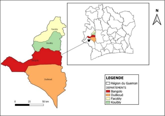
Figure 1. Geographic location of the Guémon Region.
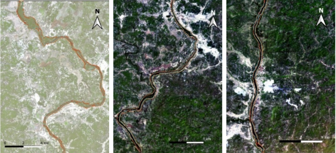
Figure 2. Superposition of river-channel traces from 2016, 2020, and 2024.
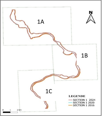
Figure 3. Superposition of river-channel traces for Section 1 (1A, 1B, and 1C).
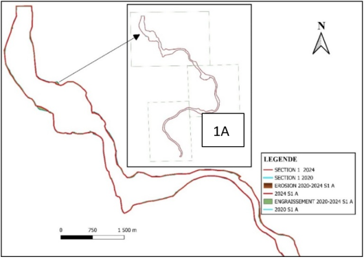
Figure 4. River evolution in Section 1A (2016–2020 and 2020–2024).
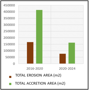
Figure 5. Erosion and accretion areas in Section 1A.
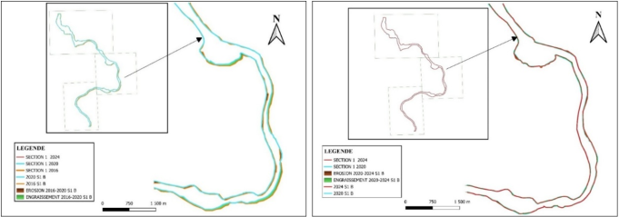
Figure 6. River evolution in Section 1B (2016–2020 and 2020–2024.
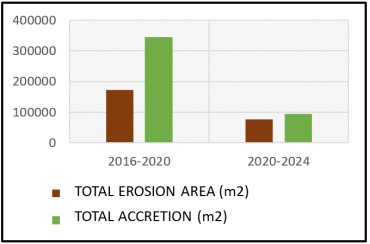
Figure 7. Erosion and accretion areas in Section 1B. the 2016-2020 and 2020-2024.
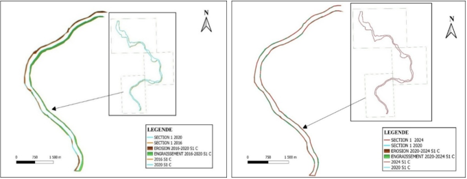
Figure 8. River evolution in Section 1C (2016–2020 and 2020–2024).
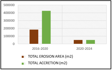
Figure 9. Erosion and accretion areas in Section 1C the 2016-2020 and 2020-2024.
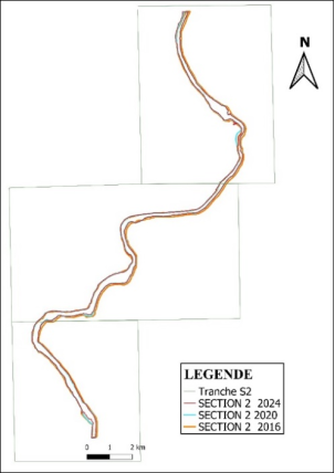
Figure 10. Superposition of river-channel traces for Section 2 (2A, 2B et 2C) in the Kanébly.
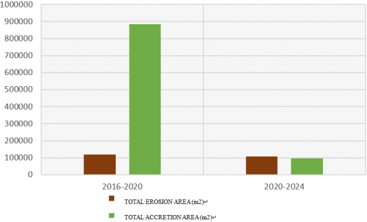
Figure 11. Erosion and accretion areas in Section 2A de 2016-2020 and 2020-2024.
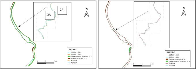
Figure 12. River evolution in Section 2A (2016-2020 and 2020-2024).
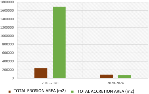
Figure 13. Erosion and accretion areas in Section 2B the 2016-2020 and 2020-2024.
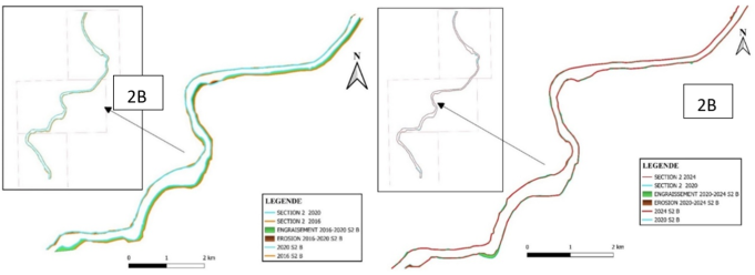
Figure 14. River evolution in Section 2B (2016-2020 and 2020-2024).
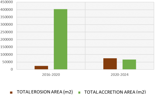
Figure 15. Erosion and accretion areas in Section 2C the 2016-2020 and 2020-2024.
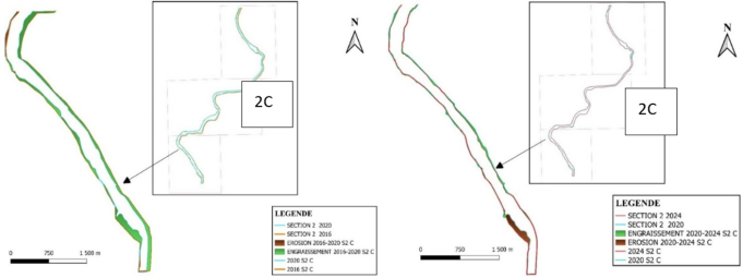
Figure 16. River evolution in Section 2C (2016-2020 and 2020-2024).
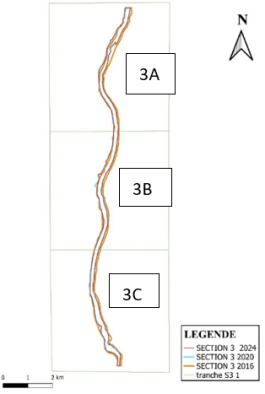
Figure 17. Superposition of river-channel traces for Section 3 (section 3A, 3B et 3C) in the Piébly and Sinikosson.
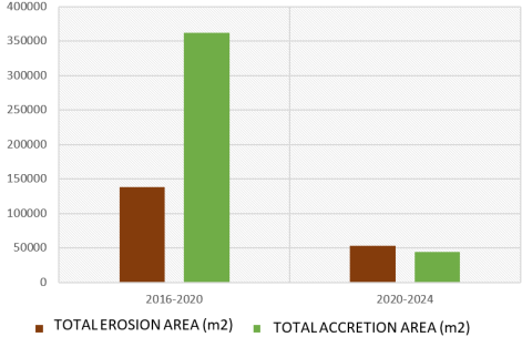
Figure 181. Erosion and accretion areas in Section 3A the 2016-2020 and 2020-2024.
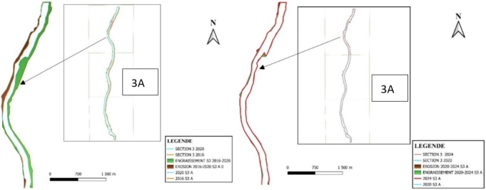
Figure 19. River evolution in Section 3A (2016-2020 and 2020-2024).
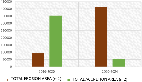
Figure 20. Erosion and accretion areas in Section 3B the 2016-2020 and 2020-2024.
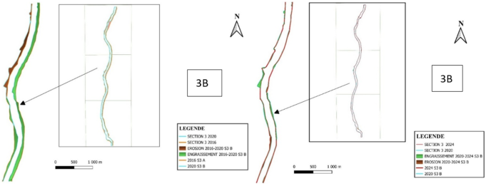
Figure 21. River evolution in Section 3B (2016-2020 and 2020-2024).
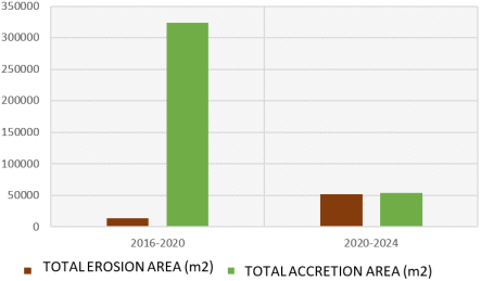
Figure 22. Erosion and accretion areas in Section 3C the 2016-2020 and 2020-2024.
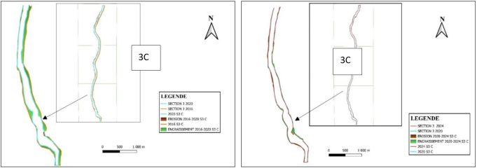
Figure 23. River evolution in Section 3C (2016-2020 and 2020-2024 and 2016-2020 and 2020-2024.
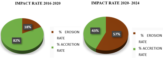
Figure 24. Assessment of erosion and accretion impact rates the 2016-2020 and the 2020-2024.
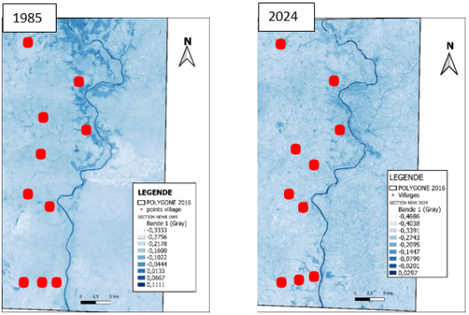
Figure 25. NDWI maps of the Comoé Estuary for 1985 and 2024.
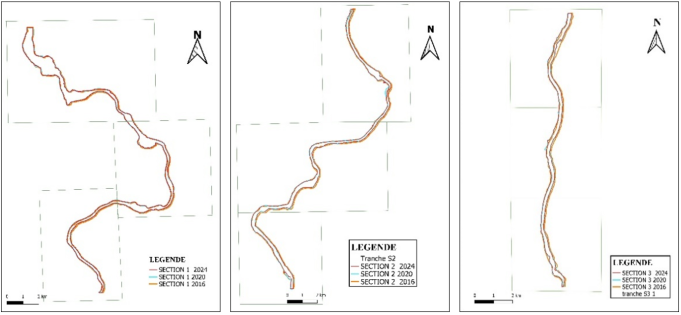
Figure 26. River-channel traces used for sinuosity analysis 2016, 2020, 2024.

Information


 Share This Article
 Twitter
 Linked In
 Facebook
 Copy
Copy Download