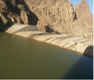
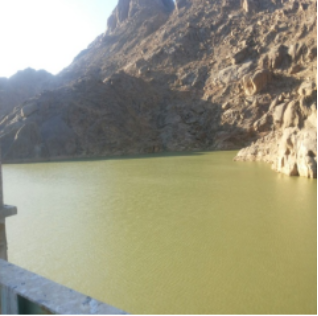
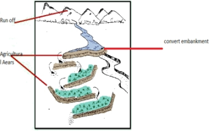
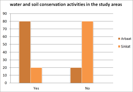
The present study aimed to investigate the effect of dams constructed for providing drinking water and for irrigation in the Red Sea state of Sudan. Water harvesting programs implemented by government with assistance of international non-governmental organization were investigated for their effectiveness. The study utilized secondary data literature and some photos of the dam. The area of study is located in the northeast of Sudan latitude 16°-22°N; longitude 35°-37°E. The primary data covered both direct questionnaire and key persons discussion. The area of study constituted about 10% of the total area of Sudan. As described by reports, the topography composed of rocky hills, mountains, outcrop rocks and a network of seasonal watercourses and streams. The hilly nature of the topography and the Basement Complex formation of the base rock made surface rain run-off the only source of fresh water. Open key person discussion pointed to the limited water supply due to geologic and climatic factors. Surface run-off is provided by seasonal stream where Khor Arba’ provides 60% of fresh drinking water, the amounts are affected by years of drought. Water distribution is controlled through a pipe network. Five major catchments were identified according to hydrological and morphological features and were important supply for rain-fed agriculture. The total annual groundwater recharge is 2.06 × 10⁶ m3. The annual discharge through underground outflow at the ‘lower gate’ is 3.29 × 10⁵ m3/year. Groundwater discharge due to pumping from Khor Arba’at basin is 4.38 × 10⁶ m3/year on average. Gates were designed in the dam to reduce siltation. However, sedimentation caused pipes blockage. Results of questionnaire showed that most of the respondents at Arba’at (80%) and Sinkat (92%) were aware of the concept of water harvesting. Disiltation benefit of the dams were acknowledged at both Arba’at (61%) and Sinkat (50%), while deepening of wells was expressed by 40% at Sinkat. Water conservation activities existed at Arba’at (80%) only. Most (85%) were willing to participate in water management. Associations in respondents’ opinion were significant (P =.000) for both desalinization of dams and commitment to water conservation. The positive effects of Non-organization activities in the areas were expressed by participants in both areas. Significant (P =.000) associations could be obtained in respondent’ opinion between the two areas. Significant (P=0.00) associations between respondents’ opinion in the two areas was obtained. Also many respondents at Arba’at (98%) and Sinkat (94%) believed that traditional laws have positive effects on natural resource management.
| Published in | Science Research (Volume 13, Issue 2) |
| DOI | 10.11648/j.sr.20251302.12 |
| Page(s) | 21-31 |
| Creative Commons |
This is an Open Access article, distributed under the terms of the Creative Commons Attribution 4.0 International License (http://creativecommons.org/licenses/by/4.0/), which permits unrestricted use, distribution and reproduction in any medium or format, provided the original work is properly cited. |
| Copyright |
Copyright © The Author(s), 2025. Published by Science Publishing Group |
Dam Construction, Water Harvesting Programs, Community Perception
Average annual Surface water m3 | Main Khors and wadis |
|---|---|
18,540,000 | Arba’at |
4,667,000 | Khor saloom |
6,416,000 | Wadi amoor |
18,313,000 | Khor arab |
1,200,000 | Gadamy |
3,500,000 | Durdaib |
560,000,000 | Khor Baraka |
4,512,000 | Ashat |
10,134,000 | Khor Gob |
Sector | Water supply coverage % | |||
|---|---|---|---|---|
Current converge | 2012 | 2017 | 2022 | |
Urban | 40 | 55 | 70 | 80 |
Semi urban | 40 | 50 | 60 | 70 |
Rural population | 47 | 55 | 60 | 70 |
Livestock | 63 | 65 | 70 | 75 |
Net additional water required m/D3 | 49,343 | 86,050 | 134,849 | |
Sector | Water demand coverage m/D3 | ||||
|---|---|---|---|---|---|
Current converge | 2012 | 2017 | 2022 | 2027 | |
Urban sector | 67,525 | 88,217 | 114,299 | 147,065 | 188,103 |
Semi urban centers | 7,586 | 10,301 | 12,329 | 15,776 | 18,812 |
Rural population | 7,806 | 10,448 | 13,960554 | 17,029 | 20,960 |
Live stock | 27,513 | 32,623 | 39,178 | 47,646 | 58,670 |
TOTAL | 110,430 | 141,589 | 179,360 | 227,516 | 286,545 |
Areas | df | P value | |||
|---|---|---|---|---|---|
Arba’at | Sinkat | ||||
yes | Count | 80 | 92 | 1 | .014 |
% within areas | 80.0% | 92.0% | |||
no | Count | 20 | 8 | ||
% within areas | 20.0% | 8.0% | |||
Total | Count | 100 | 100 | ||
% within areas | 100.0% | 100.0% | |||
Areas | Df | p. value | |||
|---|---|---|---|---|---|
Arba’at | Sinkat | ||||
yes | Count | 80 | 90 | 1 | .048 |
% within areas | 80.0% | 90.0% | |||
no | Count | 20 | 10 | ||
% within areas | 20.0% | 10.0% | |||
Total | Count | 100 | 100 | ||
% within areas | 100.0% | 100.0% | |||
Areas | Df | p. value | |||
|---|---|---|---|---|---|
Arba’at | Sinkat | ||||
Desilting hafirs | Count | 20 | 10 | 3 | 0.00 |
% within areas | 20.0% | 10.0% | |||
Desilting dams | Count | 61 | 50 | ||
% within areas | 61.0% | 50.0% | |||
deeping wells | Count | 8 | 40 | ||
% within areas | 8.0% | 40.0% | |||
water shed management | Count | 11 | 0 | ||
% within areas | 11.0% | .0% | |||
Total | Count | 100 | 100 | ||
% within areas | 100.0% | 100.0% | |||
Areas | Df | p. value | |||
|---|---|---|---|---|---|
Arba’at | Sinkat | ||||
yes | Count | 10 | 85 | 1 | 000 |
% within areas | 10.0% | 85.0% | |||
no | Count | 90 | 15 | ||
% within areas | 90.0% | 15.0% | |||
Total | Count | 100 | 100 | ||
% within areas | 100.0% | 100.0% | |||
areas | Df | p. value | |||
|---|---|---|---|---|---|
Arba’at | Sinkat | ||||
NGOs | Count | 52 | 20 | 1 | 0.00 |
% within areas | 52.0% | 20.0% | |||
GOs | Count | 48 | 80 | ||
% within areas | 48.0% | 80.0% | |||
Total | Count | 100 | 100 | ||
% within areas | 100.0% | 100.0% | |||
Areas | df | p. value | |||
|---|---|---|---|---|---|
Arba’at | Sinkat | ||||
yes | Count | 98 | 96 | 1 | .407 |
% within areas | 98.0% | 96.0% | |||
no | Count | 2 | 4 | ||
% within areas | 2.0% | 4.0% | |||
Total | Count | 100 | 100 | ||
% within areas | 100.0% | 100.0% | |||
Arba’at | Sinkat | df | p. value | ||
|---|---|---|---|---|---|
yes | Count | 98 | 94 | 1 | .149 |
% within areas | 98.0% | 94.0% | |||
no | Count | 2 | 6 | ||
% within areas | 2.0% | 6.0% | |||
Total | Count | 100 | 100 | ||
% within areas | 100.0% | 100.0% |
| [1] | Abbas, B and Tilley, P. 1991. Camel Pastoralism in the Horn of Africa Red Sea Province, Sudan. Nomadic Peoples No. 29. pp. 77-86 (10 pages) Published By: White Horse Press. |
| [2] | Abdelsalam, M. G. and Steen, R. J. 1993. Water resources in the arid realm. Book reviews. Volume 18, Issue 1. |
| [3] | Scoones, I. 1995. Living With Uncertainty: New Directions in Pastoral Development in Africa. |
| [4] | Taha, A., Taha, B., Sadik, G., Aboul-Atta, N. 2006. Surface Water Study in Eastern Part of Sudan (Khor Arba’at Case Study). Research Gate, |
APA Style
Mohamed, N. M., Mohamed, M. M. (2025). Impacts of Dams Construction and Water Harvesting Programs on Community Perception Red Sea in Eastern Sudan. Science Research, 13(2), 21-31. https://doi.org/10.11648/j.sr.20251302.12
ACS Style
Mohamed, N. M.; Mohamed, M. M. Impacts of Dams Construction and Water Harvesting Programs on Community Perception Red Sea in Eastern Sudan. Sci. Res. 2025, 13(2), 21-31. doi: 10.11648/j.sr.20251302.12
@article{10.11648/j.sr.20251302.12,
  author = {Nawara Mohamed Mohamed and Muna Mahjoub Mohamed},
  title = {Impacts of Dams Construction and Water Harvesting Programs on Community Perception Red Sea in Eastern Sudan
},
  journal = {Science Research},
  volume = {13},
  number = {2},
  pages = {21-31},
  doi = {10.11648/j.sr.20251302.12},
  url = {https://doi.org/10.11648/j.sr.20251302.12},
  eprint = {https://article.sciencepublishinggroup.com/pdf/10.11648.j.sr.20251302.12},
  abstract = {The present study aimed to investigate the effect of dams constructed for providing drinking water and for irrigation in the Red Sea state of Sudan. Water harvesting programs implemented by government with assistance of international non-governmental organization were investigated for their effectiveness. The study utilized secondary data literature and some photos of the dam. The area of study is located in the northeast of Sudan latitude 16°-22°N; longitude 35°-37°E. The primary data covered both direct questionnaire and key persons discussion. The area of study constituted about 10% of the total area of Sudan. As described by reports, the topography composed of rocky hills, mountains, outcrop rocks and a network of seasonal watercourses and streams. The hilly nature of the topography and the Basement Complex formation of the base rock made surface rain run-off the only source of fresh water. Open key person discussion pointed to the limited water supply due to geologic and climatic factors. Surface run-off is provided by seasonal stream where Khor Arba’ provides 60% of fresh drinking water, the amounts are affected by years of drought. Water distribution is controlled through a pipe network. Five major catchments were identified according to hydrological and morphological features and were important supply for rain-fed agriculture. The total annual groundwater recharge is 2.06 × 10⁶ m3. The annual discharge through underground outflow at the ‘lower gate’ is 3.29 × 10⁵ m3/year. Groundwater discharge due to pumping from Khor Arba’at basin is 4.38 × 10⁶ m3/year on average. Gates were designed in the dam to reduce siltation. However, sedimentation caused pipes blockage. Results of questionnaire showed that most of the respondents at Arba’at (80%) and Sinkat (92%) were aware of the concept of water harvesting. Disiltation benefit of the dams were acknowledged at both Arba’at (61%) and Sinkat (50%), while deepening of wells was expressed by 40% at Sinkat. Water conservation activities existed at Arba’at (80%) only. Most (85%) were willing to participate in water management. Associations in respondents’ opinion were significant (P =.000) for both desalinization of dams and commitment to water conservation. The positive effects of Non-organization activities in the areas were expressed by participants in both areas. Significant (P =.000) associations could be obtained in respondent’ opinion between the two areas. Significant (P=0.00) associations between respondents’ opinion in the two areas was obtained. Also many respondents at Arba’at (98%) and Sinkat (94%) believed that traditional laws have positive effects on natural resource management.},
 year = {2025}
}
TY  - JOUR
T1  - Impacts of Dams Construction and Water Harvesting Programs on Community Perception Red Sea in Eastern Sudan

AU  - Nawara Mohamed Mohamed
AU  - Muna Mahjoub Mohamed
Y1  - 2025/07/14
PY  - 2025
N1  - https://doi.org/10.11648/j.sr.20251302.12
DO  - 10.11648/j.sr.20251302.12
T2  - Science Research
JF  - Science Research
JO  - Science Research
SP  - 21
EP  - 31
PB  - Science Publishing Group
SN  - 2329-0927
UR  - https://doi.org/10.11648/j.sr.20251302.12
AB  - The present study aimed to investigate the effect of dams constructed for providing drinking water and for irrigation in the Red Sea state of Sudan. Water harvesting programs implemented by government with assistance of international non-governmental organization were investigated for their effectiveness. The study utilized secondary data literature and some photos of the dam. The area of study is located in the northeast of Sudan latitude 16°-22°N; longitude 35°-37°E. The primary data covered both direct questionnaire and key persons discussion. The area of study constituted about 10% of the total area of Sudan. As described by reports, the topography composed of rocky hills, mountains, outcrop rocks and a network of seasonal watercourses and streams. The hilly nature of the topography and the Basement Complex formation of the base rock made surface rain run-off the only source of fresh water. Open key person discussion pointed to the limited water supply due to geologic and climatic factors. Surface run-off is provided by seasonal stream where Khor Arba’ provides 60% of fresh drinking water, the amounts are affected by years of drought. Water distribution is controlled through a pipe network. Five major catchments were identified according to hydrological and morphological features and were important supply for rain-fed agriculture. The total annual groundwater recharge is 2.06 × 10⁶ m3. The annual discharge through underground outflow at the ‘lower gate’ is 3.29 × 10⁵ m3/year. Groundwater discharge due to pumping from Khor Arba’at basin is 4.38 × 10⁶ m3/year on average. Gates were designed in the dam to reduce siltation. However, sedimentation caused pipes blockage. Results of questionnaire showed that most of the respondents at Arba’at (80%) and Sinkat (92%) were aware of the concept of water harvesting. Disiltation benefit of the dams were acknowledged at both Arba’at (61%) and Sinkat (50%), while deepening of wells was expressed by 40% at Sinkat. Water conservation activities existed at Arba’at (80%) only. Most (85%) were willing to participate in water management. Associations in respondents’ opinion were significant (P =.000) for both desalinization of dams and commitment to water conservation. The positive effects of Non-organization activities in the areas were expressed by participants in both areas. Significant (P =.000) associations could be obtained in respondent’ opinion between the two areas. Significant (P=0.00) associations between respondents’ opinion in the two areas was obtained. Also many respondents at Arba’at (98%) and Sinkat (94%) believed that traditional laws have positive effects on natural resource management.
VL  - 13
IS  - 2
ER  -
Faculty of Sustainable Rural Development, Department of Rural Extension and Education Development, Ahfad Women University, Omdurman, Sudan
Institute of Environmental Studies, Arid Land Coordination Department, University of Khartoum, Khartoum, Sudan
Information