
Against the backdrop of the county-level urbanization strategy and the comprehensive establishment of the territorial spatial planning system, augmenting county development momentum and elevating spatial carrying capacity have become pivotal to achieving high-quality regional development. Taking Zhejiang Province as an empirical study area, this paper establishes a three-dimensional evaluation framework encompassing "scale, form, and spatial distribution." Utilizing landscape pattern analysis alongside the Gravity-Geographically and Temporally Weighted Regression (Gravity-GTWR) model, this study systematically analyzes the spatio-temporal evolution of county urban construction land and elucidates its underlying driving mechanisms driven by government, market, and social forces from 1980 to 2024.The empirical findings reveal that: (1) Urban construction land in counties has exhibited persistent spatial expansion, morphological boundary complexification, and localized patch agglomeration, evolving into five distinct carrying capacity patterns, including the fractal/complex large-patch type. Spatial scale is significantly positively correlated with morphological complexity, underscoring the stringent requirements of developmental momentum for spatial compactness. (2) While demographic aggregation and economic growth serve as the primary impetuses, the tripartite interaction among governmental planning control, market capital allocation, and civic societal responsiveness dictates the structural efficiency of carrying capacity release, displaying profound spatial heterogeneity between northeastern and southwestern Zhejiang. (3) The acute contradiction between constrained regional resource endowments and high-intensity development momentum has provoked localized land overexpansion and spatial fragmentation, thereby circumscribing the enhancement of comprehensive carrying capacity and threatening ecological security.Consequently, this paper suggests: reinforcing the transmission of territorial spatial planning to safeguard baseline carrying capacities, implementing differentiated spatial interventions across typologies to invigorate endogenous development momentum, and constructing a diversified governance framework characterized by "government leadership, market empowerment, and social collaboration," thereby providing scientific guidance and empirical references for bolstering county-level comprehensive carrying capacity and sustainable development.
| Published in | Science Innovation (Volume 14, Issue 6) |
| DOI | 10.11648/j.si.20261406.15 |
| Page(s) | 252-260 |
| Creative Commons |
This is an Open Access article, distributed under the terms of the Creative Commons Attribution 4.0 International License (http://creativecommons.org/licenses/by/4.0/), which permits unrestricted use, distribution and reproduction in any medium or format, provided the original work is properly cited. |
| Copyright |
Copyright © The Author(s), 2026. Published by Science Publishing Group |
Urban Construction Land, County Carrying Capacity, Development Momentum, Spatiotemporal Evolution, Spatial Governance, Zhejiang Province
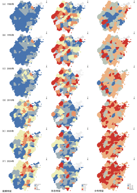
指数名称 | 水平 | 意义 |
|---|---|---|
斑块面积(CA) | 类型 | 表现某种用地斑块的总体面积规模。 |
面积加权平均斑块分维数(FRAC-AM) | 类型 | 指景观不规则几何形状的非整数维数,反映景观中斑块形状的复杂程度。 |
面积加权平均斑块最近距离(ENN-AM) | 类型 | 描述景观中同类斑块的紧凑程度,距离越大说明斑块间越分散。 |
因素类别 | 因素亚类 | 解释变量 | 逻辑内涵 |
|---|---|---|---|
增长动能 | 经济总量 | 人均GDP | 县域发展的根本经济推力 |
产业结构 | 二、三产业产值比 | 产业转型升级对空间置换的动能 | |
投资拉动 | 人均固定资产投资 | 政府与市场对基础设施承载力的投入强度 | |
社会载体 | 人口集聚 | 人口密度 | 空间承载的对象基数与服务需求动能 |
公共保障 | 人均地方财政支出 | 政府提升公共设施承载水平的保障能力 | |
消费活力 | 人均年末储蓄存款全额 | 社会主体对品质空间需求的响应动能 |
类型划分 | 空间几何特征 | 承载力与动能表现 | 典型图谱 | |
|---|---|---|---|---|
集 聚 型 | 分形/复杂大斑块型 | 规模>50 km²或城镇化率大于50%,形态复杂 | 强动能驱动型:人口与产业极度集聚,承载压力大,需侧重空间更新与存量提质 |
|
分形小斑块型 | 规模较小,形状复杂,ENN<5000 m | 潜力爆发型:处于快速扩张期,发展动能强劲但用地略显无序,需强化规划引导 |
| |
复杂小斑块型 | 规模适中,形态较复杂 | 稳步增长型:动能释放较为平稳,空间紧凑度有待提升,是承载力优化的重点区 |
| |
简单小斑块型 | 规模较小,形态规整 | 初级发育型:发展动能尚待挖掘,空间承载力富余,具备高起点的规划塑造空间 |
| |
散布型 | 规模小,分布极散(ENN 5000 m) | 动能匮乏型:城镇空间呈“飞地”特征,集聚动能不足,承载效能较低,需防范蔓延风险 |
| |
空间特征 | 主导动能类别 | 主导因素 | 典型代表区域 | 承载力映射逻辑 |
|---|---|---|---|---|
规模扩张 | 内生增长动能 | 人口规模、经济总量 | 浙东北(杭甬嘉绍) | 强动能驱动下的高强度集聚,承载压力趋向饱和。 |
保障性动能 | 公共财政、产业结构 | 浙东南(温台) | 民营经济驱动,承载空间随产业升级动态调整。 | |
投资驱动动能 | 投资建设、居民储蓄 | 浙中、浙西(金衢丽) | 依赖外部投入与政策支持,承载规模稳步起步。 | |
形态复杂化 | 结构转型动能 | 产业结构、经济总量 | 浙东北、浙东南 | 产业迭代引发空间重组,形态复杂化反映了动能转换的活跃度。 |
分布集约度 | 服务响应动能 | 人口密度、公共财政 | 浙西北、浙中 | 社会公共服务对人口集聚的引导,驱动空间向紧凑型承载演进。 |
| [1] | 丁寿颐, 吴唯佳, 刘冠男. 首都地区城乡建设用地空间格局与增长趋势——基于2000-2010年数据 [J]. 城市规划, 2017, 41(06): |
| [2] | 岳文泽, 周秋实, 李蒙蒙, 等. 面向主体功能分区的建设用地强度研究: 模式识别与时空演变 [J]. 城市规划, 2023, 47(05): 15-24. |
| [3] | 鞠洪润, 张生瑞, 闫逸晨. 1980—2020年粤港澳大湾区城镇用地空间格局类型演变及其驱动力多维探测 [J]. 地理学报, 2022, 77(05): 1086-1101. |
| [4] | 舒帮荣, 朱建军, 李永乐等. 不同经济发展阶段下城市用地规模扩张动力研究——基于省际面板数据的考察 [J]. 中国土地科学, 2013, 27(11): 65-71. |
| [5] | 龙瀛, 吴康. 中国城市化的几个现实问题: 空间扩张、人口收缩、低密度人类活动与城市范围界定 [J]. 城市规划学刊, 2016, No. 228(02): 72-77. |
| [6] | Swyngedouw E, Moulaert F, Rodriguez A. Neoliberal Urbanization in Europe: Large–Scale Urban Development Projects and the New Urban Policy [J]. Antipode, 2002. |
| [7] | Beall J, Khasnobis B G, Kanbur R. Urbanization and Development in Asia: Multidimensional Perspectives [M]. Oxford University Press, 2012. |
| [8] | Seto K C, Fragkias M. Quantifying spatiotemporal patterns of urban land-use change in four cities of China with time series landscape metrics [J]. Landscape Ecology, 2005, 20: 871-888. |
| [9] | Li J, Zhao H M. Detecting urban land-use and land-cover changes in Mississauga using Landsat TM images [J]. Journal of Environmental Informatics, 2003, 2(1): 38-47. |
| [10] | 方创琳, 李广东, 张蔷. 中国城市建设用地的动态变化态势与调控 [J]. 自然资源学报, 2017, 32(03): 363-376. |
| [11] | 闫昊生, 孙久文, 张泽邦. 中国城市建设用地供应的时空演变分析 [J]. 城市发展研究, 2021, 28(09): 42-49+2. |
| [12] | 赵小风, 刘梦丽, 王柏源. 基于地理探测器的城市建设用地规模时空差异及影响因素分析 [J]. 中国土地科学, 2018, 32(05): 29-35. |
| [13] | 童陆亿, 胡守庚. 中国主要城市建设用地扩张特征 [J]. 资源科学, 2016, 38(01): 50-61. |
| [14] | 刘沁萍, 朱闯, 田洪阵等. 2001~2017年中国建设用地时空分异特征 [J]. 长江流域资源与环境, 2020, 29(10): 2113-2123. |
| [15] | 史玉琴, 李艳, 曹宇. 浙江省建设用地扩展时空特征分析 [J]. 长江流域资源与环境, 2010, 19 (S2): 114-121. |
| [16] | 刘耀林, 李纪伟, 侯贺平等. 湖北省城乡建设用地城镇化率及其影响因素 [J]. 地理研究, 2014, 33(01): 132-142. |
| [17] | 王丹, 吴世新, 张寿雨. 新疆20世纪80年代末以来耕地与建设用地扩张分析 [J]. 干旱区地理, 2017, 40(01): 188-196. |
| [18] | 赵志威, 王冬艳, 李红等. 吉林省中部地区后备城镇建设用地潜力及空间分布研究 [J]. 长江流域资源与环境, 2020, 29(01): 55-65. |
| [19] | 胡莹洁, 孔祥斌, 张宝东. 30年来北京市土地利用时空变化特征 [J]. 中国农业大学学报, 2018, 23(11): 1-14. |
| [20] | 向冬蕾, 李建华, 刘洋等. 环滇池城区建设用地扩张及驱动机理研究 [J]. 西南大学学报(自然科学版), 2019, 41(10): 117-124. |
| [21] | 乔文怡, 黄贤金. 长三角城市群城镇用地扩展时空格局及驱动力解析 [J]. 经济地理, 2021, 41(09): 162-173. |
| [22] | 王灿, 王继富, 任春颖, 王宗明, 姚云长. 1970s-2015年长春市城市扩张过程时空动态分析 [J]. 干旱区资源与环境, 2017, 31(03): 21-25. |
| [23] | 车通, 李成, 罗云建. 城市扩张过程中建设用地景观格局演变特征及其驱动力 [J]. 生态学报, 2020, 40(10): 3283-3294. |
| [24] | 戴德艺, 饶映雪, 刘殿锋, 刘成武. 1989~2015年武汉市城市格局时空演变分析 [J]. 长江流域资源与环境, 2016, 25(10): 1545-1554. |
APA Style
Wang, X., Wang, D., Wang, L. (2026). Evolution of County Urban Land and Carrying Capacity Enhancement in Zhejiang Province. Science Innovation, 14(6), 252-260. https://doi.org/10.11648/j.si.20261406.15
ACS Style
Wang, X.; Wang, D.; Wang, L. Evolution of County Urban Land and Carrying Capacity Enhancement in Zhejiang Province. Sci. Innov. 2026, 14(6), 252-260. doi: 10.11648/j.si.20261406.15
@article{10.11648/j.si.20261406.15,
  author = {Xueqi Wang and Daixia Wang and Lei Wang},
  title = {Evolution of County Urban Land and Carrying Capacity Enhancement in Zhejiang Province},
  journal = {Science Innovation},
  volume = {14},
  number = {6},
  pages = {252-260},
  doi = {10.11648/j.si.20261406.15},
  url = {https://doi.org/10.11648/j.si.20261406.15},
  eprint = {https://article.sciencepublishinggroup.com/pdf/10.11648.j.si.20261406.15},
  abstract = {Against the backdrop of the county-level urbanization strategy and the comprehensive establishment of the territorial spatial planning system, augmenting county development momentum and elevating spatial carrying capacity have become pivotal to achieving high-quality regional development. Taking Zhejiang Province as an empirical study area, this paper establishes a three-dimensional evaluation framework encompassing "scale, form, and spatial distribution." Utilizing landscape pattern analysis alongside the Gravity-Geographically and Temporally Weighted Regression (Gravity-GTWR) model, this study systematically analyzes the spatio-temporal evolution of county urban construction land and elucidates its underlying driving mechanisms driven by government, market, and social forces from 1980 to 2024.The empirical findings reveal that: (1) Urban construction land in counties has exhibited persistent spatial expansion, morphological boundary complexification, and localized patch agglomeration, evolving into five distinct carrying capacity patterns, including the fractal/complex large-patch type. Spatial scale is significantly positively correlated with morphological complexity, underscoring the stringent requirements of developmental momentum for spatial compactness. (2) While demographic aggregation and economic growth serve as the primary impetuses, the tripartite interaction among governmental planning control, market capital allocation, and civic societal responsiveness dictates the structural efficiency of carrying capacity release, displaying profound spatial heterogeneity between northeastern and southwestern Zhejiang. (3) The acute contradiction between constrained regional resource endowments and high-intensity development momentum has provoked localized land overexpansion and spatial fragmentation, thereby circumscribing the enhancement of comprehensive carrying capacity and threatening ecological security.Consequently, this paper suggests: reinforcing the transmission of territorial spatial planning to safeguard baseline carrying capacities, implementing differentiated spatial interventions across typologies to invigorate endogenous development momentum, and constructing a diversified governance framework characterized by "government leadership, market empowerment, and social collaboration," thereby providing scientific guidance and empirical references for bolstering county-level comprehensive carrying capacity and sustainable development.},
 year = {2026}
}
TY  - JOUR
T1  - Evolution of County Urban Land and Carrying Capacity Enhancement in Zhejiang Province
AU  - Xueqi Wang
AU  - Daixia Wang
AU  - Lei Wang
Y1  - 2026/11/10
PY  - 2026
N1  - https://doi.org/10.11648/j.si.20261406.15
DO  - 10.11648/j.si.20261406.15
T2  - Science Innovation
JF  - Science Innovation
JO  - Science Innovation
SP  - 252
EP  - 260
PB  - Science Publishing Group
SN  - 2328-787X
UR  - https://doi.org/10.11648/j.si.20261406.15
AB  - Against the backdrop of the county-level urbanization strategy and the comprehensive establishment of the territorial spatial planning system, augmenting county development momentum and elevating spatial carrying capacity have become pivotal to achieving high-quality regional development. Taking Zhejiang Province as an empirical study area, this paper establishes a three-dimensional evaluation framework encompassing "scale, form, and spatial distribution." Utilizing landscape pattern analysis alongside the Gravity-Geographically and Temporally Weighted Regression (Gravity-GTWR) model, this study systematically analyzes the spatio-temporal evolution of county urban construction land and elucidates its underlying driving mechanisms driven by government, market, and social forces from 1980 to 2024.The empirical findings reveal that: (1) Urban construction land in counties has exhibited persistent spatial expansion, morphological boundary complexification, and localized patch agglomeration, evolving into five distinct carrying capacity patterns, including the fractal/complex large-patch type. Spatial scale is significantly positively correlated with morphological complexity, underscoring the stringent requirements of developmental momentum for spatial compactness. (2) While demographic aggregation and economic growth serve as the primary impetuses, the tripartite interaction among governmental planning control, market capital allocation, and civic societal responsiveness dictates the structural efficiency of carrying capacity release, displaying profound spatial heterogeneity between northeastern and southwestern Zhejiang. (3) The acute contradiction between constrained regional resource endowments and high-intensity development momentum has provoked localized land overexpansion and spatial fragmentation, thereby circumscribing the enhancement of comprehensive carrying capacity and threatening ecological security.Consequently, this paper suggests: reinforcing the transmission of territorial spatial planning to safeguard baseline carrying capacities, implementing differentiated spatial interventions across typologies to invigorate endogenous development momentum, and constructing a diversified governance framework characterized by "government leadership, market empowerment, and social collaboration," thereby providing scientific guidance and empirical references for bolstering county-level comprehensive carrying capacity and sustainable development.
VL  - 14
IS  - 6
ER  -
College of Design and Architecture, Zhejiang University of Technology, Hangzhou, China
College of Design and Architecture, Zhejiang University of Technology, Hangzhou, China
Zhejiang University Urban-Rural Planning and Design Institute Co., Ltd., Hangzhou, China

Information


 Share This Article
 Twitter
 Linked In
 Facebook



 Copy
 Download