
In this comprehensive study, researcher investigate the complex interplay between land use changes, vegetation health as measured by NDVI, and carbon monoxide (CO) concentration in the Bugesera District from 2019 to 2022 using Google Earth Engine. The introduction sets the context by highlighting the environmental significance of understanding this relationship in a region marked by rapid urbanization and shifting land use patterns. A thorough literature review underscores the global relevance of this topic, discussing the impact of urban development, transportation, and industrialization on both vegetation health and air quality. The methodology section outlines data collection methods and analytical techniques, emphasizing the use of remote sensing technology and GIS for spatial analysis accompanied by Machine Learning in Google Earth Engine. The results demonstrate a clear inverse correlation between NDVI and CO concentration, particularly in areas with high urbanization and infrastructural development, validating the negative impact of human activities on vegetation and air quality. The discussion delves into the implications of these findings, emphasizing the need for sustainable urban planning and environmental conservation efforts. Finally, the conclusion summarizes the study's significance, offering actionable recommendations for policymakers and urban planners to promote healthier, more resilient ecosystems and improved air quality in the Bugesera District and similar rapidly evolving regions.
| Published in | Journal of Chemical, Environmental and Biological Engineering (Volume 10, Issue 2) |
| DOI | 10.11648/j.jcebe.20261002.13 |
| Page(s) | 57-66 |
| Creative Commons |
This is an Open Access article, distributed under the terms of the Creative Commons Attribution 4.0 International License (http://creativecommons.org/licenses/by/4.0/), which permits unrestricted use, distribution and reproduction in any medium or format, provided the original work is properly cited. |
| Copyright |
Copyright © The Author(s), 2026. Published by Science Publishing Group |
Correlation, NDVI, Carbon Monoxide (CO), Land Use Change and Urbanization
Data Name | Measurement | Dataset Availability | Resolution | Source |
|---|---|---|---|---|
CO column number density | mol/m2 | 2018-06-28 to 2023-10-03 | 7.0 x 7.0 Km | Sentinel-5P OFFL CO |
NDVI | No Unit range From -1 to +1 | 2017-03-28 to 2023-10-06 | 10 x 10 m | Sentinel-2 MSI |
Month | CO column number density (2019) in mol/m2 | CO column number density (2020) in mol/m2 | CO column number density (2021) in mol/m2 | CO column number density (2022) in mol/m2 |
|---|---|---|---|---|
Jan | 0.035 | 0.037 | 0.036 | 0.037 |
Feb | 0.034 | 0.035 | 0.044 | 0.035 |
Mar | 0.032 | 0.035 | 0.033 | 0.035 |
Apr | 0.029 | 0.03 | 0.026 | 0.03 |
May | 0.026 | 0.027 | 0.028 | 0.027 |
Jun | 0.039 | 0.033 | 0.032 | 0.033 |
Jul | 0.038 | 0.038 | 0.039 | 0.038 |
Aug | 0.037 | 0.041 | 0.04 | 0.041 |
Sep | 0.037 | 0.038 | 0.037 | 0.038 |
Oct | 0.031 | 0.037 | 0.035 | 0.037 |
Nov | 0.03 | 0.031 | 0.034 | 0.031 |
Dec | 0.031 | 0.032 | 0.031 | 0.032 |
Month | NDVI Value (2019) | NDVI Value (2020) | NDVI Value (2021) | NDVI Value (2022) |
|---|---|---|---|---|
Jan | 0.656 | 0.614 | 0.588 | 0.557 |
Feb | 0.606 | 0.565 | 0.539 | 0.484 |
Mar | 0.592 | 0.551 | 0.521 | 0.486 |
Apr | 0.633 | 0.587 | 0.572 | 0.523 |
May | 0.658 | 0.622 | 0.571 | 0.543 |
Jun | 0.603 | 0.549 | 0.503 | 0.457 |
Jul | 0.483 | 0.436 | 0.39 | 0.335 |
Aug | 0.387 | 0.345 | 0.302 | 0.274 |
Sep | 0.352 | 0.317 | 0.282 | 0.241 |
Oct | 0.413 | 0.356 | 0.328 | 0.271 |
Nov | 0.512 | 0.521 | 0.426 | 0.365 |
Dec | 0.637 | 0.597 | 0.526 | 0.509 |
NDVI | Normalized Difference Vegetation Index |
CO | Carbon Monoxide |
GIS | Geographic Information System |
WHO | World Health Organization |
SO2 | Sulfur Dioxide |
PM10 | Particulate Matter with Diameter ≤ 10 Micrometers |
PM2.5 | Particulate Matter with Diameter ≤ 2.5 Micrometers |
NO2 | Nitrogen Dioxide |
O3 | Ozone |
TROPOMI | TROPOspheric Monitoring Instrument |
MSI | MultiSpectral Instrument |
Sentinel-5P | Sentinel-5 Precursor |
COVID-19 | Coronavirus Disease 2019 |
Km | Kilometer |
M | Meter |
mol/m2 | Moles Per Square Meter |
| [1] | Dastoorpoor, M., et al., Air pollution and hospital admissions for cardiovascular diseases in Ahvaz, Iran. 2019. 652: p. 1318-1330. |
| [2] |
WHO, Ambient (outdoor) air pollution.
https://www.who.int/news-room/fact-sheets/detail/ambient-(outdoor)-air-quality-and-health 2022. |
| [3] |
HEI, State of Global Air 2019. A special report on global exposure to air Pollution and its Disease Burden. 2019
https://www.stateofglobalair.org/sites/default/files/soga_2019_report.pdf |
| [4] | Akbarzadeh, M. A., et al., The association between exposure to air pollutants including PM10, PM2.5, ozone, carbon monoxide, sulfur dioxide, and nitrogen dioxide concentration and the relative risk of developing STEMI: A case-crossover design. 2018. 161: p. 299-303. |
| [5] | Berhe, A. A., et al., The significance of the erosion-induced terrestrial carbon sink. 2007. 57(4): p. 337-346. |
| [6] | Rao, E., et al., Preservation of soil organic carbon (SOC) through ecosystems’ soil retention services in China. 2023. 12(9): p. 1718. |
| [7] | Thapa, P., The Relationship between Land Use and Climate Change: A Case Study of Nepal. In The Nature, Causes, Effects and Mitigation of Climate Change on the Environment. IntechOpen.. 2022: p. 71. |
| [8] | Akinyemi, F. O. J. A. G., Land change in the central Albertine rift: Insights from analysis and mapping of land use-land cover change in north-western Rwanda. 2017. 87: p. 127-138. |
| [9] | Ntihinyurwa, P. D., et al., The positive impacts of farm land fragmentation in Rwanda. 2019. 81: p. 565-581. |
| [10] | Kayigema, V., An assessment of the Girinka (one cow per poor family) program and poverty alleviation in Rwanda: a case study of Bugesera District. 2013, University of KwaZulu-Natal, Durban. |
| [11] | Li, A. M. J. E. S. and P. Research, Ecological determinants of health: food and environment on human health. 2017. 24(10): p. 9002-9015. |
| [12] | Madronich, S., et al., Changes in tropospheric air quality related to the protection of stratospheric ozone in a changing climate. 2023. 22(5): p. 1129-1176. |
| [13] | Bourgeois, I., et al., Large contribution of biomass burning emissions to ozone throughout the global remote troposphere. 2021. 118(52): p. e2109628118. |
| [14] | Sharma, A., Rajput, P. (2022). Role of Biomass Burning in Greenhouse Gases Emission. In: Sonwani, S., Saxena, P. (eds) Greenhouse Gases: Sources, Sinks and Mitigation. Springer, Singapore. |
| [15] | Jiang, H., et al., Biomass burning organic aerosols significantly influence the light absorption properties of polarity-dependent organic compounds in the Pearl River Delta Region, China. 2020. 144: p. 106079. |
| [16] | Maurya, N. K., et al., Spatio-temporal monitoring of atmospheric pollutants using earth observation sentinel 5P TROPOMI data: impact of stubble burning a case study. 2022. 11(5): p. 301. |
| [17] | Magro, C., et al., Atmospheric trends of CO and CH4 from extreme wildfires in Portugal using Sentinel-5P TROPOMI level-2 data. 2021. 4(2): p. 25. |
| [18] | Landgraf, J., et al., Carbon monoxide total column retrievals from TROPOMI shortwave infrared measurements. 2016. 9(10): p. 4955-4975. |
| [19] |
Lucas, D., and R. G. Prinn (2005): Parametric sensitivity and uncertainty analysis of dimethylsulfide oxidation in the clear-sky marine boundary layer. Atmospheric Chemistry and Physics, 5: 1505-1525
https://www.atmos-chem-phys.org/5/1505/2005/acp-5-1505-2005.html |
| [20] | Satyanarayana, B., et al., Assessment of mangrove vegetation based on remote sensing and ground-truth measurements at Tumpat, Kelantan Delta, East Coast of Peninsular Malaysia. 2011. 32(6): p. 1635-1650. |
| [21] | Zhou, P., et al., Dynamic change of vegetation index and its influencing factors in alxa league in the arid area. 2022. 10: p. 922739. |
| [22] | Ali, S., Haixing, Z., Qi, M. et al. Monitoring drought events and vegetation dynamics in relation to climate change over mainland China from 1983 to 2016. Environ Sci Pollut Res 28, 21910–21925 (2021). |
| [23] | Wieczorek, B. J. R. S., Air pollution patterns mapping of SO2, NO2, and CO derived from TROPOMI over Central-East Europe. 2023. 15(6): p. 1565. |
| [24] | Gatti, L. V., Basso, L. S., Miller, J. B. et al. Amazonia as a carbon source linked to deforestation and climate change. Nature 595, 388–393 (2021). |
| [25] | Bower, J., et al. An agenda for spatial economic research in Rwanda. 2022. IGC. theigc.org/sites/default/files/2022/04/Bower-et-al-Final-Report-March-2022.pdf |
| [26] | Zhu, L., Xing, H. & Hou, D. Analysis of carbon emissions from land cover change during 2000 to 2020 in Shandong Province, China. Sci Rep 12, 8021 (2022). |
| [27] | Uwamahoro, L., G. Nyagatare, and C. Shingiro, Effect of different composts on soil chemical conditions and green bean yield in Bugesera District, Eastern Province of Rwanda. 2019. 5: p. 132-137. |
| [28] | Rwanyiziri, G., & Rugema, J. (2013). Climate Change Effects on Food Security in Rwanda: Case Study of Wetland Rice Production in Bugesera District. Rwanda Journal, 1(1), 35–51. |
| [29] | MUHIZI, M. S. A., Rural urbanization and food in/security: a case study of Bugesera district. 2019, University of Rwanda. |
| [30] | Cai, Y.-B., et al., Land use pattern, socio-economic development, and assessment of their impacts on ecosystem service value: study on natural wetlands distribution area (NWDA) in Fuzhou city, southeastern China. 2013. 185(6): p. 5111-5123. |
| [31] | Dale, V. H. J. E.a., The relationship between land‐use change and climate change. 1997. 7(3): p. 753-769. |
| [32] | Inubushi, K., et al., Seasonal changes of CO2, CH4 and N2O fluxes in relation to land-use change in tropical peatlands located in coastal area of South Kalimantan. 2003. 52(3): p. 603-608. |
| [33] | Zhou, C., S. Wang, and J. J. S. o. t. T. E. Wang, Examining the influences of urbanization on carbon dioxide emissions in the Yangtze River Delta, China: Kuznets curve relationship. 2019. 675: p. 472-482. |
| [34] | Frioni, T., C. Pastore, and M. P. J. F. i. P. S. Diago, Resilience of grapevine to climate change: from plant physiology to adaptation strategies, volume II. 2023, Frontiers Media SA. p. 1268158. |
| [35] | Millimet, D. L., J. J. J. o. t. A. o. E. Alix-Garcia, and R. Economists, Introduction to causal inference in environmental and resource economics: Challenges, developments, and applications. 2021. 8(2): p. 193-198. |
| [36] | Pace, G., et al., Remote sensing indicators to assess riparian vegetation and river ecosystem health. 2022. 144: p. 109519. |
| [37] | Joel, N. Ecological sustainability in urban landscapes and smart cities, Case Study Kigali City, Rwanda. in Proceedings of the 11th IALE World Congress. 2023. |
| [38] | Halder, B., et al., Monitoring the effect of urban development on urban heat island based on remote sensing and geo-spatial approach in Kolkata and adjacent areas, India. 2021. 74: p. 103186. |
| [39] | Shao, Z., et al., Urban sprawl and its impact on sustainable urban development: a combination of remote sensing and social media data. 2021. 24(2): p. 241-255. |
| [40] | Anwar, M. N., et al., Emerging challenges of air pollution and particulate matter in China, India, and Pakistan and mitigating solutions. 2021. 416: p. 125851. |
| [41] | Tariq, A., Graciano, C., Sardans, J., Zeng, F., Hughes, A. C., Ahmed, Z., Ullah, A., Ali, S., Gao, Y. and Peñuelas, J. (2024), Plant root mechanisms and their effects on carbon and nutrient accumulation in desert ecosystems under changes in land use and climate. New Phytol, 242: 916-934. |
APA Style
Ndayisaba, J., Nshimiyumuremyi, T., Tuyizere, M. N., Ndagijwenimana, E. (2026). The Influence of Changes in Land Use on the Concentration of Carbon Monoxide (CO) as an Indicator of Climate Change in Bugesera District. Journal of Chemical, Environmental and Biological Engineering, 10(2), 57-66. https://doi.org/10.11648/j.jcebe.20261002.13
ACS Style
Ndayisaba, J.; Nshimiyumuremyi, T.; Tuyizere, M. N.; Ndagijwenimana, E. The Influence of Changes in Land Use on the Concentration of Carbon Monoxide (CO) as an Indicator of Climate Change in Bugesera District. J. Chem. Environ. Biol. Eng. 2026, 10(2), 57-66. doi: 10.11648/j.jcebe.20261002.13
AMA Style
Ndayisaba J, Nshimiyumuremyi T, Tuyizere MN, Ndagijwenimana E. The Influence of Changes in Land Use on the Concentration of Carbon Monoxide (CO) as an Indicator of Climate Change in Bugesera District. J Chem Environ Biol Eng. 2026;10(2):57-66. doi: 10.11648/j.jcebe.20261002.13
@article{10.11648/j.jcebe.20261002.13,
  author = {Joel Ndayisaba and Theodore Nshimiyumuremyi and Mucyo Ndera Tuyizere and Eric Ndagijwenimana},
  title = {The Influence of Changes in Land Use on the Concentration of Carbon Monoxide (CO) as an Indicator of Climate Change in Bugesera District},
  journal = {Journal of Chemical, Environmental and Biological Engineering},
  volume = {10},
  number = {2},
  pages = {57-66},
  doi = {10.11648/j.jcebe.20261002.13},
  url = {https://doi.org/10.11648/j.jcebe.20261002.13},
  eprint = {https://article.sciencepublishinggroup.com/pdf/10.11648.j.jcebe.20261002.13},
  abstract = {In this comprehensive study, researcher investigate the complex interplay between land use changes, vegetation health as measured by NDVI, and carbon monoxide (CO) concentration in the Bugesera District from 2019 to 2022 using Google Earth Engine. The introduction sets the context by highlighting the environmental significance of understanding this relationship in a region marked by rapid urbanization and shifting land use patterns. A thorough literature review underscores the global relevance of this topic, discussing the impact of urban development, transportation, and industrialization on both vegetation health and air quality. The methodology section outlines data collection methods and analytical techniques, emphasizing the use of remote sensing technology and GIS for spatial analysis accompanied by Machine Learning in Google Earth Engine. The results demonstrate a clear inverse correlation between NDVI and CO concentration, particularly in areas with high urbanization and infrastructural development, validating the negative impact of human activities on vegetation and air quality. The discussion delves into the implications of these findings, emphasizing the need for sustainable urban planning and environmental conservation efforts. Finally, the conclusion summarizes the study's significance, offering actionable recommendations for policymakers and urban planners to promote healthier, more resilient ecosystems and improved air quality in the Bugesera District and similar rapidly evolving regions.},
 year = {2026}
}
TY  - JOUR
T1  - The Influence of Changes in Land Use on the Concentration of Carbon Monoxide (CO) as an Indicator of Climate Change in Bugesera District
AU  - Joel Ndayisaba
AU  - Theodore Nshimiyumuremyi
AU  - Mucyo Ndera Tuyizere
AU  - Eric Ndagijwenimana
Y1  - 2026/11/06
PY  - 2026
N1  - https://doi.org/10.11648/j.jcebe.20261002.13
DO  - 10.11648/j.jcebe.20261002.13
T2  - Journal of Chemical, Environmental and Biological Engineering
JF  - Journal of Chemical, Environmental and Biological Engineering
JO  - Journal of Chemical, Environmental and Biological Engineering
SP  - 57
EP  - 66
PB  - Science Publishing Group
SN  - 2640-267X
UR  - https://doi.org/10.11648/j.jcebe.20261002.13
AB  - In this comprehensive study, researcher investigate the complex interplay between land use changes, vegetation health as measured by NDVI, and carbon monoxide (CO) concentration in the Bugesera District from 2019 to 2022 using Google Earth Engine. The introduction sets the context by highlighting the environmental significance of understanding this relationship in a region marked by rapid urbanization and shifting land use patterns. A thorough literature review underscores the global relevance of this topic, discussing the impact of urban development, transportation, and industrialization on both vegetation health and air quality. The methodology section outlines data collection methods and analytical techniques, emphasizing the use of remote sensing technology and GIS for spatial analysis accompanied by Machine Learning in Google Earth Engine. The results demonstrate a clear inverse correlation between NDVI and CO concentration, particularly in areas with high urbanization and infrastructural development, validating the negative impact of human activities on vegetation and air quality. The discussion delves into the implications of these findings, emphasizing the need for sustainable urban planning and environmental conservation efforts. Finally, the conclusion summarizes the study's significance, offering actionable recommendations for policymakers and urban planners to promote healthier, more resilient ecosystems and improved air quality in the Bugesera District and similar rapidly evolving regions.
VL  - 10
IS  - 2
ER  -
Spatial Planning Department, University of Rwanda, Kigali, Rwanda;Centre for Geographic Information System (CGIS), University of Rwanda, Kigali, Rwanda;Monitoring and Evaluation Department, Albertine Rift Conservation Society (ARCOS), Kigali, Rwanda
Monitoring and Evaluation Department, Albertine Rift Conservation Society (ARCOS), Kigali, Rwanda;Center of Excellence in Biodiversity and Natural Resource Management (CoEB), University of Rwanda, Kigali, Rwanda
Spatial Planning Department, University of Rwanda, Kigali, Rwanda;Centre for Geographic Information System (CGIS), University of Rwanda, Kigali, Rwanda
Monitoring and Evaluation Department, Albertine Rift Conservation Society (ARCOS), Kigali, Rwanda
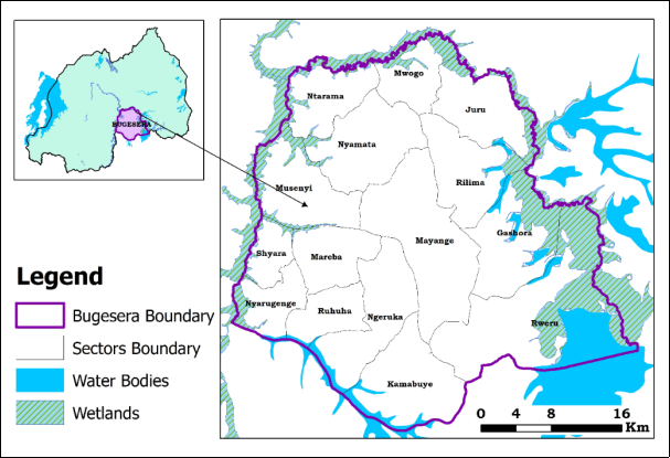
Figure 1. Bugesera study area map located in Eastern Province.
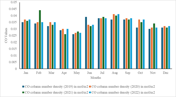
Figure 2. Carbon monoxide distribution 2019-2022.
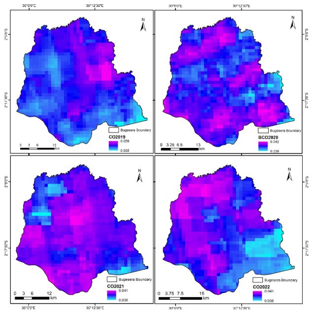
Figure 3. Spatio-temporal analysis of Carbon monoxide from 2019-2022 where A, B, C and D represent Carbon monoxide concentration in the study area from 2019, 2020, 2021, and 2022 respectively.
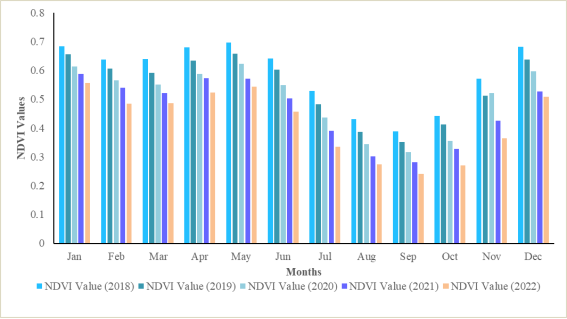
Figure 4. NDVI Values distribution in Bugesera Landscape.
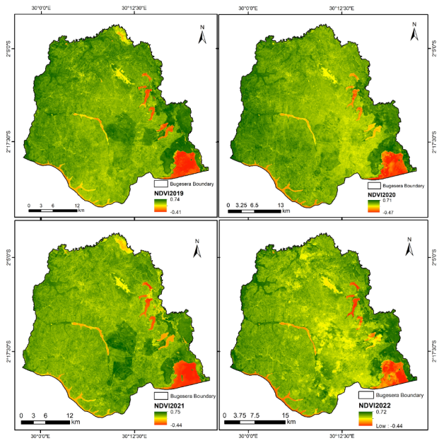
Figure 5. Spatio-Temporal Analysis NDVI of study area region from 2019-2022, where A, B, C and D represent NDVI from 2019, 2020, 2021, and 2022 respectively.
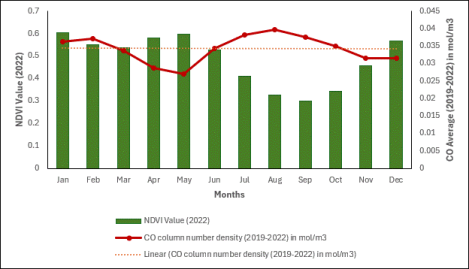
Figure 6. Graph shows how NDVI and Carbon Monoxide are related from 2019-2022.

Information



 Share This Article
 Twitter
 Linked In
 Facebook

 Copy
 Download