Abstract
Sudan’s Gum Arabic Belt is an ecologically important dryland landscape and a source of income for rural households, particularly through the production of gum from Senegalia senegal (hashab) and Vachellia seyal (talh). Its extent and condition are changing under the combined pressures of drought, agricultural expansion, tree cutting, market constraints, and armed conflict. This paper synthesizes the evolution of mapping approaches used to describe and manage the belt, from early ecological boundary maps to administrative delineations, satellite-based land-cover monitoring, species-level mapping, and climate-based suitability projections. The synthesis draws on historical maps and published studies identified in the source manuscript and selected methodological literature; it does not present a new satellite classification or independently rerun climate models. The reviewed material illustrates how ecological maps established a baseline, administrative maps supported rehabilitation planning, and remote sensing made it possible to compare land-cover conditions over time. The source manuscript reports a 38% decline in dense Acacia cover between 1990 and 2018 and a projected 36–87% increase in climatically suitable habitat for S. senegal under future scenarios; these estimates should be treated as reported findings pending verification of their original methods and uncertainty. Species-level mapping may improve targeting of restoration, while climate projections can help identify areas for field testing rather than justify immediate large-scale planting. The paper proposes a coordinated national geospatial system linking satellite observations, field validation, community monitoring, climate scenarios, and livelihood information. Such a system could improve restoration priorities; reduce duplication among institutions, and support adaptive management of the Gum Arabic Belt.
Keywords
Climate Adaptation, Dryland Restoration, Geographic Information Systems, Gum Arabic, Remote Sensing, Sudan
1. Introduction
Sudan’s Gum Arabic Belt (GAB) is a broad dryland production landscape in which trees, crops, livestock, and rural livelihoods interact. The belt is particularly associated with
Senegalia senegal (L.) Britton, commonly called hashab, and
Vachellia seyal (Delile) P. J. H. Hurter, commonly called talh. Gum from these species contributes to domestic livelihoods and international supply chains, while the trees and associated vegetation provide shade, organic matter, soil protection, and other ecosystem services. Earlier studies describe the ecological range of
S. senegal and the role of gum gardens in Sudanese agro-silvopastoral systems
| [7] | Ballal, M. E. 1991. Acacia senegal: A multipurpose tree species for arid and semiarid tropics. M. Sc. thesis, University of Wales, United Kingdom. |
| [8] | Coppen, J. J. W. 1995. Gums, resins and latexes of plant origin. Non-Wood Forest Products No. 6. Rome: Food and Agriculture Organization of the United Nations. |
| [16] | Jamal, A., and L. Huntsinger. 1993. Deterioration of a sustainable agro-silvopastoral system in the Sudan: The gum gardens of Kordofan. Agroforestry Systems 23: 23–38. |
[7, 8, 16]
. However, Sudan is the world’s biggest producer of gum arabic, which is also the main source of gum in international trade
| [8] | Coppen, J. J. W. 1995. Gums, resins and latexes of plant origin. Non-Wood Forest Products No. 6. Rome: Food and Agriculture Organization of the United Nations. |
[8]
. Of the 36 varieties of gum producing
Acacias found in the Sudan, the major producers of marketable gum are
A. senegal (hashab gum) and
A. seyal (talh gum)
| [16] | Jamal, A., and L. Huntsinger. 1993. Deterioration of a sustainable agro-silvopastoral system in the Sudan: The gum gardens of Kordofan. Agroforestry Systems 23: 23–38. |
[16]
.
Senegalia senegal (L.) occur naturally in a belt 300km wide extending through the Sahra Desert, from Mauritania to Sudan, Ethiopia, Somalia, also in east Africa and extends southwards to Mozambique, Transvaal, Natal, along the coast of Africa and Iran and in Pakistan and Northwest India
| [19] | Ross, J. H. 1979. A conspectus of the African Acacia species. Memoirs of the Botanical Survey of South Africa No. 44. |
[19]
.
A. senegal in Sudan grows naturally in the gum belt (Latitude 10° and 14° N). This broad ecological region represents a complex and diverse environment with regard to climate, soils, vegetation, animals and human activities
| [7] | Ballal, M. E. 1991. Acacia senegal: A multipurpose tree species for arid and semiarid tropics. M. Sc. thesis, University of Wales, United Kingdom. |
[7]
. These factors were reported by
| [7] | Ballal, M. E. 1991. Acacia senegal: A multipurpose tree species for arid and semiarid tropics. M. Sc. thesis, University of Wales, United Kingdom. |
[7]
. to have an impact on gum yield. The
A. senegal tree species is grown successfully in Kordofan, Darfur, western White Nile and in the central clay plains
| [1] | Ahmed, A. E. 1986. Some aspects of dry land afforestation in the Sudan with special reference to Acacia tortilis (Forssk.) Hayne, A. senegal Willd., and Prosopis chilensis (Molina) Stuntz. Forest Ecology and Management 16: 209–221. |
| [5] | Awouda, H. M. 1990. Indicators for present and future supply of gum Arabic. In Gums and stabilizers for the food industry, edited by G. O. Phillips and P. A. Williams, 45–54. Oxford: IRL Press. |
| [6] | Badi, K. H. M., A. E. Ahmed, and M. S. Bayoumi. 1989. The forests of the Sudan. Khartoum, Sudan: Agricultural Research Council. |
[1, 5, 6]
. It supplies 70 to 90% of the world's gum arabic (near-monopoly on a vital global commodity). Also the tree was found under an average rainfall of 500 mm in the central clay plains
| [1] | Ahmed, A. E. 1986. Some aspects of dry land afforestation in the Sudan with special reference to Acacia tortilis (Forssk.) Hayne, A. senegal Willd., and Prosopis chilensis (Molina) Stuntz. Forest Ecology and Management 16: 209–221. |
| [5] | Awouda, H. M. 1990. Indicators for present and future supply of gum Arabic. In Gums and stabilizers for the food industry, edited by G. O. Phillips and P. A. Williams, 45–54. Oxford: IRL Press. |
| [15] | International Institute for Environment and Development (IIED) and Institute of Environmental Studies (IES). 1989. Gum Arabic rehabilitation in the Republic of the Sudan: Stage I report. London and Khartoum. |
[1, 5, 15]
. but can even grow under 200 mm of rain, with 8-11 arid months, to 800 mm
| [15] | International Institute for Environment and Development (IIED) and Institute of Environmental Studies (IES). 1989. Gum Arabic rehabilitation in the Republic of the Sudan: Stage I report. London and Khartoum. |
| [18] | National Academy of Sciences (NAS). 1979. Firewood crops: Shrub and tree species for energy production. Volumes 1–2. Washington, DC: National Academy Press. |
[15, 18]
. The latter rainfall can cause water longing in clay soils and might hamper the growth and survival of the species. It supports livelihoods for roughly 5 million Sudanese citizens (farmers and harvesters to traders and exporters), it is contributing a significant 12% to the national GDP
| [10] | El Khalifa, M. D., M. O. El Samani, H. O. Abdel Nour, D. W. Pearee, F. B. Barbier, A. Markang, and J. C. Burgess. 1989. Gum Arabic Belt rehabilitation in the Republic of the Sudan. Stage I report, Volume 3. Khartoum, Sudan: Institute of Environmental Studies, University of Khartoum, and International Institute for Environment and Development. |
[10]
.
The belt is not a uniform strip with constant ecological or administrative boundaries. Rainfall, soil, vegetation, land use, and management vary across locations, and these differences influence tree establishment and gum production
| [20] | Seif El Din, A. 1984. Agroforestry Practices in the Dry Regions. At-Tasahur, Vol. 2, 8 – 9. |
[20]
. Historical assessments identified drought, conversion of gum gardens to crop production, mechanized agriculture, cutting for fuelwood or charcoal, limited incentives for tree planting, and household cash constraints as contributors to degradation
| [8] | Coppen, J. J. W. 1995. Gums, resins and latexes of plant origin. Non-Wood Forest Products No. 6. Rome: Food and Agriculture Organization of the United Nations. |
| [12] | Hansen, M. C., P. V. Potapov, R. Moore, M. Hancher, S. A. Turubanova, A. Tyukavina, D. Thau, S. V. Stehman, S. J. Goetz, T. R. Loveland, A. Kommareddy, A. Egorov, L. Chini, C. O. Justice, and J. R. G. Townshend. 2013. High-resolution global maps of 21st-century forest cover change. Science 342: 850–853. https://doi.org/10.1126/science.1244693 |
| [20] | Seif El Din, A. 1984. Agroforestry Practices in the Dry Regions. At-Tasahur, Vol. 2, 8 – 9. |
[8, 12, 20]
. More recently, armed conflict and displacement have complicated access to production areas, field surveys, natural-resource governance, and the continuity of monitoring. Conflict-related land-use change has also been documented in Darfur using satellite data
| [2] | Ahmed, A., B. Rotich, and K. Czimber. 2024. Assessment of the environmental impacts of conflict-driven internally displaced persons: A Sentinel-2 satellite-based analysis of land use/cover changes in the Kas locality, Darfur, Sudan. PLoS ONE 19: e0304034.
https://doi.org/10.1371/journal.pone.0304034 |
| [17] | Mohammed, E. M. I., A. A. Ahmed, and F. I. Musa. 2026. Mapping and monitoring land-use changes of the Gum Arabic Belt in armed conflict-disturbed areas to support sustainable management of the belt. Scientific Reports.
https://doi.org/10.1038/s41598-026-69562-8 |
[2, 17]
, and satellite-based studies in other drylands, such as northeast Syria, have linked cropland abandonment to the combined effects of drought, economic restructuring, and migration
| [9] | Eklund, L., B. Mohr, and P. Dinc. 2024. Cropland abandonment in the context of drought, economic restructuring, and migration in northeast Syria. Environmental Research Letters 19: 014077.
https://doi.org/10.1088/1748-9326/ad1723 |
[9]
. Also communities’ participation was practical for the rehabilitation of the gum belt and several communities based projects were implemented e.g. UNSO, SOS, ODA, NORAD, CARE … etc.
| [3] | Ali, S. A. 2003. Early survival and establishment of Acacia senegal (L.) Willd. in the sandy soils of Goz Ashgar Central Forest Reserve, North Kordofan, Sudan. M. Sc. thesis, University of Khartoum, Khartoum, Sudan. |
[3]
. Among these countries, Sudan stands out with prolonged armed conflicts and humanitarian crises since South Sudan warfare, Nuba Mountains, Blue Nile, Darfur, and recently in Khartoum, the central regions, and western regions
| [2] | Ahmed, A., B. Rotich, and K. Czimber. 2024. Assessment of the environmental impacts of conflict-driven internally displaced persons: A Sentinel-2 satellite-based analysis of land use/cover changes in the Kas locality, Darfur, Sudan. PLoS ONE 19: e0304034.
https://doi.org/10.1371/journal.pone.0304034 |
| [4] | Assal, M. A. M. 2023. War in Sudan 15 April 2023: Background, analysis and scenarios. IDEA Working Paper.
https://doi.org/10.31752/idea.2023.60 |
| [21] | Yousif, T. A., A. R. A. Mohamed, E. M. Ibrahim, and F. E. Ahmed. 2015. Causes of bank erosion of Wadi Kaja Basin—West Darfur State, Sudan. Journal of Natural Resources and Environmental Studies 3: 1–8. |
[2, 4, 21]
. The ongoing war led to the death of thousands, within the country immigrations, and many refugee camps in neighboring countries.
Mapping can make these interacting pressures more visible, but maps differ in purpose and evidential strength. Ecological maps represent potential or expected distribution; administrative maps define a manageable area for institutions and programs; satellite-derived maps estimate observed land cover at particular dates; species-level maps attempt to distinguish target trees from other vegetation; and climate suitability models estimate potential future environmental conditions. These products should not be treated as interchangeable. In particular, modeled suitability does not establish that trees are present, regenerating, or economically viable, and land-cover change does not by itself identify the cause of change.
Earth-observation archives and cloud-based geospatial platforms have expanded the capacity to compare land-cover conditions across large areas and long periods
| [11] | Gorelick, N., M. Hancher, M. Dixon, S. Ilyushchenko, D. Thau, and R. Moore. 2017. Google Earth Engine: Planetary-scale geospatial analysis for everyone. Remote Sensing of Environment 202: 18–27.
https://doi.org/10.1016/j.rse.2017.06.031 |
| [12] | Hansen, M. C., P. V. Potapov, R. Moore, M. Hancher, S. A. Turubanova, A. Tyukavina, D. Thau, S. V. Stehman, S. J. Goetz, T. R. Loveland, A. Kommareddy, A. Egorov, L. Chini, C. O. Justice, and J. R. G. Townshend. 2013. High-resolution global maps of 21st-century forest cover change. Science 342: 850–853. https://doi.org/10.1126/science.1244693 |
[11, 12]
. However, robust interpretation requires transparent classification methods, accuracy assessment, and field validation. This is especially important where insecurity limits ground observations and where mixed land uses or sparse dryland vegetation can complicate classification. Climate projections likewise require scenario-based interpretation and should be integrated with local ecological knowledge and adaptation planning
| [14] | Intergovernmental Panel on Climate Change (IPCC). 2022. Africa. In Climate change 2022: Impacts, adaptation and vulnerability, edited by H.-O. Pörtner et al., 1285–1455. Cambridge: Cambridge University Press.
https://doi.org/10.1017/9781009325844.011 |
[14]
.
The objective of this paper is to synthesize the evolution of mapping approaches applied to Sudan’s Gum Arabic Belt, assess their contributions and limitations for resource management, and propose a practical national framework for evidence-based monitoring, restoration, and climate adaptation.
2. Materials and Methods
2.1. Study Approach
This paper uses a narrative, comparative synthesis of historical cartographic products and published or otherwise cited studies summarized in the source manuscript. It is not a new field survey, a systematic review, or an independent remote-sensing analysis. The purpose is to organize the available material by mapping approach, identify what each approach can support, and derive recommendations for future management and research.
2.2. Materials Reviewed
The materials included: (1) the ecological boundary map attributed to Harrison and Jackson (1958); (2) administrative delineations and rehabilitation assessments associated with the late 1980s, including IIED and IES (1989); (3) land-cover maps described in the source manuscript as derived from Landsat imagery for 1990 and 2018; (4) a species-level mapping example using spectral information and principal component analysis (PCA), attributed in the source material to 2023; and (5) projected suitability maps for S. senegal based on three climate models—GISS-E2-1-G, MPI-ESM1-2-HR, and IPSL-CM6A-LR under SSP2-4.5 and SSP5-8.5 for four future periods between 2021 and 2100. The associated images are reproduced from the supplied manuscript and should be checked against the original publications before submission.
2.3. Comparative Framework
Each mapping stage was compared qualitatively using five criteria: (1) primary purpose; (2) spatial and temporal information represented; (3) management decisions it can support; (4) principal limitations; and (5) requirements for validation and updating. The comparison distinguished observed land-cover conditions from modeled climate suitability and distinguished landscape-level mapping from species-level mapping.
2.4. Interpretation of Reported Quantitative Findings
Two quantitative findings are carried forward as reported in the source manuscript: a 38% decline in dense Acacia cover between 1990 and 2018, and a 36–87% projected increase in suitable habitat for S. senegal under future climate scenarios. The original classification files, accuracy statistics, suitability thresholds, and model outputs were not available for independent recalculation in this synthesis. Accordingly, these figures are not presented as independently verified estimates. They should be confirmed against the original studies before publication and should be accompanied by definitions of the mapped classes, spatial extent, baseline, and uncertainty.
2.5. Limitations of the Approach
The synthesis is constrained by incomplete methodological details for some historical and recent maps, uneven availability of ground-reference data, and the absence of original raster data and model outputs. It therefore evaluates the management implications of the mapping sequence rather than claiming a new quantitative assessment of forest loss or future habitat change.
3. Results and Discussion
3.1. Evolution of Mapping: From Ecological Potential to Adaptive Management
The reviewed material indicates four broad stages in the mapping of the Gum Arabic Belt. Each stage responded to a different information need, and the stages are best understood as complementary rather than as a simple replacement of older maps by newer technology
Table 1.
Table 1. Evolution of mapping: from ecological potential to adaptive management.
Mapping stage | Main contribution | Principal limitation | Management use |
Ecological baseline (1958) | Represented the broad ecological distribution or potential range of the Acacia belt. | Static representation; limited ability to show later land-use change or degradation. | Historical reference for ecological zoning and comparison. |
Administrative delineation (1980s) | Provided a practical area for coordinating rehabilitation, field activities, and support. | Administrative boundaries may not reflect fine-scale ecological variation or changing conditions. | Program planning, institutional coordination, and broad resource allocation. |
Satellite-based monitoring (1990 onward) | Enabled repeated observation of land cover and comparison across dates. | Classification error, sensor differences, and limited field validation can affect estimates. | Detecting change, locating potential degradation hotspots, and tracking restoration. |
Species mapping and climate suitability (recent studies) | Offers more targeted information on target species and potential future environments. | Species discrimination and model projections require validation; suitability is not proof of establishment. | Prioritizing field surveys, restoration trials, and adaptive planning. |
The ecological baseline attributed to
| [13] | Harrison, M. N. and Jackson, J. K., (1958). Ecological classification of the vegetation of the Sudan. Forest Bulletin No.2 (new series). Agricultural Publications Committee, Khartoum. |
[13]
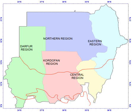
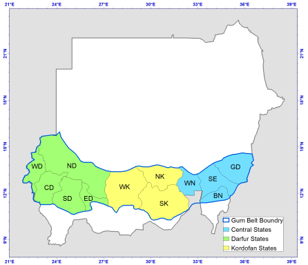
remains useful as a historical reference, but its static nature limits its value for operational monitoring. Administrative maps developed in the context of severe drought and rehabilitation needs during the 1980s provided a manageable geography for programs. However, a fixed boundary can obscure local variation and shifts in land use or climate. A contemporary national system should retain these historical products as reference layers while using regularly updated observations to assess current conditions.
Figure 1. Regional delineation associated with the historical administrative representation of the Gum Arabic Belt.
Figure 2. Administrative zones of the gum arabic belt.
3.2. Satellite-based Land-cover Change
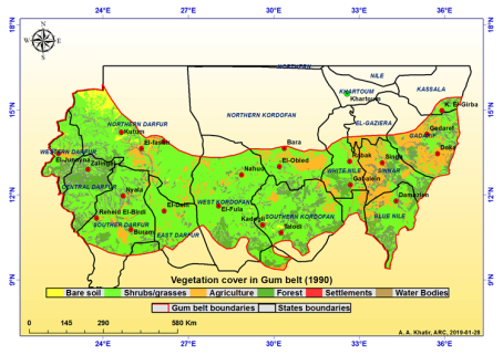
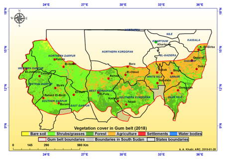
The manuscript describes a comparison of Landsat imagery for 1990 and 2018. The reported workflow involved image preprocessing, classification into six land-use/land-cover classes, pixel-by-pixel comparison, and calculation of change matrices. This is a suitable general framework for long-term change analysis, provided that image dates, seasonal conditions, class definitions, training data, and classification accuracy are reported consistently. Differences between sensors and the effects of rainfall variability can otherwise be mistaken for persistent land-cover change.
The source manuscript reports that dense Acacia cover declined by 38% over the 1990–2018 interval. This figure is potentially important for planning, but its interpretation depends on what “dense Acacia cover” means, whether the mapped area and class definitions were identical across dates, and whether the estimate refers to relative percentage change or a percentage-point difference. The underlying study should report the area in hectares or square kilometers for each date, the change calculation, classification accuracy, and uncertainty. Without those details, the 38% figure should be treated as a provisional reported result rather than a fully verified national estimate.
Figure 3. Land-cover map of the Gum Arabic Belt for 1990.
Figure 4. Land-cover map of the Gum Arabic Belt for 2018.
The broader value of satellite monitoring is that it can provide repeatable evidence of where land cover may have changed. Global forest-change research demonstrates the potential of satellite archives to map forest loss and gain at spatially explicit resolutions
| [12] | Hansen, M. C., P. V. Potapov, R. Moore, M. Hancher, S. A. Turubanova, A. Tyukavina, D. Thau, S. V. Stehman, S. J. Goetz, T. R. Loveland, A. Kommareddy, A. Egorov, L. Chini, C. O. Justice, and J. R. G. Townshend. 2013. High-resolution global maps of 21st-century forest cover change. Science 342: 850–853. https://doi.org/10.1126/science.1244693 |
[12]
. Cloud-based processing can reduce some computational barriers and support repeatable workflows
| [11] | Gorelick, N., M. Hancher, M. Dixon, S. Ilyushchenko, D. Thau, and R. Moore. 2017. Google Earth Engine: Planetary-scale geospatial analysis for everyone. Remote Sensing of Environment 202: 18–27.
https://doi.org/10.1016/j.rse.2017.06.031 |
[11]
. For Sudan, however, an operational system should use these capabilities alongside local classification training, seasonal composites, uncertainty reporting, and targeted ground checks wherever access is possible.
3.3. Species-level Mapping and Restoration Targeting
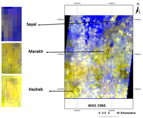
Landscape-level land-cover classes may not distinguish S. senegal from other woody species or mixed vegetation. The supplied manuscript presents a species-mapping example using spectral analysis and PCA to distinguish hashab from other mapped vegetation types. If validated, species-level information could help identify existing hashab stands, prioritize protection, and locate areas for regeneration or enrichment planting. The available material, however, does not provide enough information to assess the model’s accuracy, training sample design, seasonality, or transferability to other parts of the belt.
Figure 5. Example of species-level spectral mapping.
Species maps should therefore be used as screening products rather than definitive inventories until their accuracy is established. Validation should include reference plots distributed across soil types, rainfall zones, stand densities, and land-use contexts. Confusion matrices and class-specific producer’s and user’s accuracies should be reported, and the model should be tested in locations not used for training. Community knowledge can help select validation sites and interpret land-use history, but it should complement rather than replace quantitative accuracy assessment.
3.4. Climate Suitability Projections: Opportunity and Uncertainty
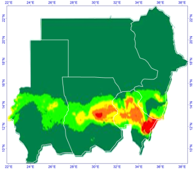
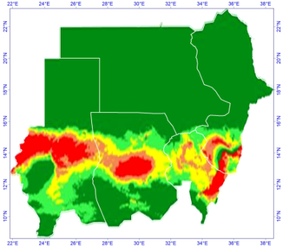
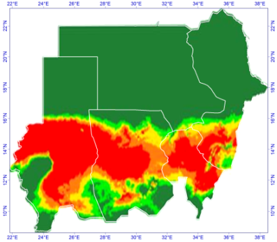
The manuscript summarizes climate-suitability projections for S. senegal using three global climate models and two Shared Socioeconomic Pathways (SSP2-4.5 and SSP5-8.5), across the periods 2021–2040, 2041–2060, 2061–2080, and 2081–2100. The source reports a potential increase of 36–87% in climatically suitable habitat. This range should not be interpreted as a forecast that tree cover or gum production will increase by the same amount. It refers to modeled suitability, which may not account fully for soil constraints, land tenure, seed availability, fire, grazing, pests, conflict, or the ability of households and institutions to establish and protect trees.
The apparent contrast between current degradation and possible future suitability is not contradictory. Forest cover can decline because of land-use pressure even where climate remains suitable, while a location becoming climatically suitable does not ensure that it will support successful regeneration. The projections are most useful for identifying candidate areas for field assessment and carefully designed restoration trials. They should be accompanied by model agreement maps, uncertainty estimates, baseline definitions, and sensitivity tests for the suitability threshold. Climate adaptation planning should consider multiple scenarios rather than relying on a single model or a single future period
| [14] | Intergovernmental Panel on Climate Change (IPCC). 2022. Africa. In Climate change 2022: Impacts, adaptation and vulnerability, edited by H.-O. Pörtner et al., 1285–1455. Cambridge: Cambridge University Press.
https://doi.org/10.1017/9781009325844.011 |
[14]
.
Figure 6. Example future suitability projection for S. senegal.
Figure 7. Additional climate-suitability projection.
Figure 8. Additional climate-suitability projection.
3.5. Implications of Conflict, Data Gaps, and Weak Institutional Coordination
The source manuscript identifies geopolitical instability, outdated maps, fragmented institutional datasets, limited ground verification, and shortages of trained personnel and high-resolution data as major barriers. These limitations are mutually reinforcing: insecurity restricts field visits; lack of field observations reduces confidence in satellite classifications; and disconnected datasets make it difficult to compare results across agencies or sustain monitoring over time. The importance of these constraints is heightened by conflict-related displacement and land-use changes documented in Darfur
| [2] | Ahmed, A., B. Rotich, and K. Czimber. 2024. Assessment of the environmental impacts of conflict-driven internally displaced persons: A Sentinel-2 satellite-based analysis of land use/cover changes in the Kas locality, Darfur, Sudan. PLoS ONE 19: e0304034.
https://doi.org/10.1371/journal.pone.0304034 |
| [16] | Jamal, A., and L. Huntsinger. 1993. Deterioration of a sustainable agro-silvopastoral system in the Sudan: The gum gardens of Kordofan. Agroforestry Systems 23: 23–38. |
[2, 16]
.
A practical response is not simply to acquire more imagery. Institutions need agreed definitions for the belt and its land-cover classes, a shared geospatial database, metadata standards, regular versioning, and transparent procedures for recording uncertainty. Local producers and community organizations can contribute observations on tree cutting, regeneration, fire, grazing, and gum production. Where access is unsafe, satellite-based alerts can guide later verification rather than be treated as confirmed events. This approach preserves analytical continuity during periods when conventional field surveys cannot be conducted.
Table 2. Challenges affect mapping and decisions and recommendation response.
Challenge | Effect on mapping and decisions | Recommended response |
Conflict and restricted access | Field verification and monitoring become intermittent; some areas are under-observed. | Use satellite time series and clearly flag unverified classifications; validate when safe access returns. |
Inconsistent map boundaries and classes | Maps from different years or agencies may not be directly comparable. | Adopt a documented national spatial framework, common class definitions, and version control. |
Limited species-level validation | Target-species maps may misclassify similar woody vegetation. | Collect stratified reference data and report confusion matrices and class-specific accuracy. |
Fragmented institutional data | Forest, agriculture, rangeland, and development programs may duplicate effort. | Maintain a shared geospatial database with named custodians and open metadata. |
Limited GIS capacity and continuity | Methods may be difficult to reproduce or update after staff turnover. | Train multidisciplinary teams, document workflows, and use repeatable processing scripts. |
Uncertain future climate suitability | Projected suitable areas may be mistaken for guaranteed restoration sites. | Use multi-model ensembles and test candidate areas through field trials before scaling up. |
3.6. Toward a National Geospatial Framework
The synthesis supports a national monitoring framework with five linked components: (1) a historical archive of ecological and administrative maps; (2) regular satellite-derived land-cover monitoring; (3) targeted species mapping validated with field data; (4) climate-suitability scenarios linked to restoration trials; and (5) community and livelihood information. The framework should treat the Gum Arabic Belt as an ecological and economic landscape rather than only a fixed cartographic polygon.
A national geospatial platform should be coordinated by relevant Sudanese forestry, agricultural research, rangeland, and planning institutions, with clear responsibilities for data collection, validation, storage, and publication. It should support routine updates while preserving earlier map versions for trend analysis. A minimum metadata record should include source imagery, acquisition dates, spatial resolution, projection, classification method, class definitions, validation design, accuracy statistics, and known limitations. For future suitability maps, metadata should additionally specify climate models, scenarios, time periods, predictor variables, thresholds, and model agreement.
The main management value of the mapping sequence is its ability to connect evidence with decisions. Historical maps help interpret change; satellite monitoring can identify areas requiring investigation; species maps can guide targeted protection and regeneration; and climate projections can inform where to test adaptation options. None of these tools replaces local institutions, secure access, producer incentives, or long-term management. Their value depends on whether information is maintained and used within a coordinated decision-making process.
4. Conclusion
Mapping of Sudan’s Gum Arabic Belt has evolved from static ecological and administrative representations toward satellite-based land-cover monitoring, species-level mapping, and climate-suitability projections. Each approach answers a different question, and their combined use offers a stronger basis for managing a dynamic dryland landscape. The reported decline in dense Acacia cover and projected expansion of suitable habitat highlight the need to distinguish observed change from modeled potential and to verify quantitative claims against original data. A coordinated geospatial system that integrates remote sensing, field validation, climate scenarios, and community knowledge could improve restoration targeting and support more adaptive management. Maps will contribute to resilient livelihoods and ecosystem recovery only when their limitations are transparent and the information is connected to institutions, incentives, and implementation capacity.
5. Recommendations
1) Create a national, shared geospatial database for the Gum Arabic Belt, with common boundaries, land-cover definitions, metadata standards, and documented map versions.
2) Reassess the reported 38% decline in dense Acacia cover using the original Landsat data, consistent class definitions, a reproducible change matrix, and independent accuracy assessment.
3) Verify the reported 36–87% increase in suitable habitat by documenting baseline conditions, climate models, emissions scenarios, suitability thresholds, uncertainty, and model agreement.
4) Validate species-level maps for S. senegal and V. seyal with stratified field reference data and report confusion matrices and class-specific accuracy before using them to allocate large restoration investments.
5) Use future climate-suitability maps to select candidate sites for small-scale restoration trials, not as evidence that natural regeneration or successful planting is guaranteed.
6) Combine satellite-based alerts with community monitoring and field verification when safe and feasible, and clearly label areas where field validation is unavailable because of conflict or access restrictions.
7) Build GIS and remote-sensing capacity within forestry, agricultural research, rangeland, and planning institutions through practical training, shared protocols, and reproducible workflows.
8) Link mapping outputs to producer organizations, restoration incentives, land-use planning, and gum value-chain programs so that ecological priorities and rural livelihood needs are considered together.
9) Update monitoring at regular intervals and publish concise status reports that distinguish observed land-cover change, validated species distribution, and modeled future suitability.
Abbreviations
PCA | Principal Component Analysis |
IIED | International Institute for Environment and Development |
GDP | Gross Domestic Product |
IES | Institute of Environmental Studies |
IPCC | Intergovernmental Panel on Climate Change |
MPI | Max Planck Institute |
CM6A | Climate Model Version 6 |
GIS | Geographic Information System |
Acknowledgments
The authors acknowledge the institutions and researchers whose historical mapping, forest research, and remote-sensing work provide the basis for this synthesis. Specific funding support was not stated in the source manuscript.
Author Contributions
Abdelrahman Ahmed Khatir: Conceptualization, Data Analysis
Kamal Eldin Mohammed Fadul: Conceptualization, Writing – original draft
Conflicts of Interest
The authors declare no conflicts of interest.
References
| [1] |
Ahmed, A. E. 1986. Some aspects of dry land afforestation in the Sudan with special reference to Acacia tortilis (Forssk.) Hayne, A. senegal Willd., and Prosopis chilensis (Molina) Stuntz. Forest Ecology and Management 16: 209–221.
|
| [2] |
Ahmed, A., B. Rotich, and K. Czimber. 2024. Assessment of the environmental impacts of conflict-driven internally displaced persons: A Sentinel-2 satellite-based analysis of land use/cover changes in the Kas locality, Darfur, Sudan. PLoS ONE 19: e0304034.
https://doi.org/10.1371/journal.pone.0304034
|
| [3] |
Ali, S. A. 2003. Early survival and establishment of Acacia senegal (L.) Willd. in the sandy soils of Goz Ashgar Central Forest Reserve, North Kordofan, Sudan. M. Sc. thesis, University of Khartoum, Khartoum, Sudan.
|
| [4] |
Assal, M. A. M. 2023. War in Sudan 15 April 2023: Background, analysis and scenarios. IDEA Working Paper.
https://doi.org/10.31752/idea.2023.60
|
| [5] |
Awouda, H. M. 1990. Indicators for present and future supply of gum Arabic. In Gums and stabilizers for the food industry, edited by G. O. Phillips and P. A. Williams, 45–54. Oxford: IRL Press.
|
| [6] |
Badi, K. H. M., A. E. Ahmed, and M. S. Bayoumi. 1989. The forests of the Sudan. Khartoum, Sudan: Agricultural Research Council.
|
| [7] |
Ballal, M. E. 1991. Acacia senegal: A multipurpose tree species for arid and semiarid tropics. M. Sc. thesis, University of Wales, United Kingdom.
|
| [8] |
Coppen, J. J. W. 1995. Gums, resins and latexes of plant origin. Non-Wood Forest Products No. 6. Rome: Food and Agriculture Organization of the United Nations.
|
| [9] |
Eklund, L., B. Mohr, and P. Dinc. 2024. Cropland abandonment in the context of drought, economic restructuring, and migration in northeast Syria. Environmental Research Letters 19: 014077.
https://doi.org/10.1088/1748-9326/ad1723
|
| [10] |
El Khalifa, M. D., M. O. El Samani, H. O. Abdel Nour, D. W. Pearee, F. B. Barbier, A. Markang, and J. C. Burgess. 1989. Gum Arabic Belt rehabilitation in the Republic of the Sudan. Stage I report, Volume 3. Khartoum, Sudan: Institute of Environmental Studies, University of Khartoum, and International Institute for Environment and Development.
|
| [11] |
Gorelick, N., M. Hancher, M. Dixon, S. Ilyushchenko, D. Thau, and R. Moore. 2017. Google Earth Engine: Planetary-scale geospatial analysis for everyone. Remote Sensing of Environment 202: 18–27.
https://doi.org/10.1016/j.rse.2017.06.031
|
| [12] |
Hansen, M. C., P. V. Potapov, R. Moore, M. Hancher, S. A. Turubanova, A. Tyukavina, D. Thau, S. V. Stehman, S. J. Goetz, T. R. Loveland, A. Kommareddy, A. Egorov, L. Chini, C. O. Justice, and J. R. G. Townshend. 2013. High-resolution global maps of 21st-century forest cover change. Science 342: 850–853.
https://doi.org/10.1126/science.1244693
|
| [13] |
Harrison, M. N. and Jackson, J. K., (1958). Ecological classification of the vegetation of the Sudan. Forest Bulletin No.2 (new series). Agricultural Publications Committee, Khartoum.
|
| [14] |
Intergovernmental Panel on Climate Change (IPCC). 2022. Africa. In Climate change 2022: Impacts, adaptation and vulnerability, edited by H.-O. Pörtner et al., 1285–1455. Cambridge: Cambridge University Press.
https://doi.org/10.1017/9781009325844.011
|
| [15] |
International Institute for Environment and Development (IIED) and Institute of Environmental Studies (IES). 1989. Gum Arabic rehabilitation in the Republic of the Sudan: Stage I report. London and Khartoum.
|
| [16] |
Jamal, A., and L. Huntsinger. 1993. Deterioration of a sustainable agro-silvopastoral system in the Sudan: The gum gardens of Kordofan. Agroforestry Systems 23: 23–38.
|
| [17] |
Mohammed, E. M. I., A. A. Ahmed, and F. I. Musa. 2026. Mapping and monitoring land-use changes of the Gum Arabic Belt in armed conflict-disturbed areas to support sustainable management of the belt. Scientific Reports.
https://doi.org/10.1038/s41598-026-69562-8
|
| [18] |
National Academy of Sciences (NAS). 1979. Firewood crops: Shrub and tree species for energy production. Volumes 1–2. Washington, DC: National Academy Press.
|
| [19] |
Ross, J. H. 1979. A conspectus of the African Acacia species. Memoirs of the Botanical Survey of South Africa No. 44.
|
| [20] |
Seif El Din, A. 1984. Agroforestry Practices in the Dry Regions. At-Tasahur, Vol. 2, 8 – 9.
|
| [21] |
Yousif, T. A., A. R. A. Mohamed, E. M. Ibrahim, and F. E. Ahmed. 2015. Causes of bank erosion of Wadi Kaja Basin—West Darfur State, Sudan. Journal of Natural Resources and Environmental Studies 3: 1–8.
|
Cite This Article
-
APA Style
Khatir, A. A., Fadul, K. E. M. (2026). From Desert Buffer to National Asset: Mapping Sudan’s Gum Arabic Belt for a Resilient Future. International Journal of Environmental Monitoring and Analysis, 14(6), 198-208. https://doi.org/10.11648/j.ijema.20261406.11
 Copy
|
 Download
ACS Style
Khatir, A. A.; Fadul, K. E. M. From Desert Buffer to National Asset: Mapping Sudan’s Gum Arabic Belt for a Resilient Future. Int. J. Environ. Monit. Anal. 2026, 14(6), 198-208. doi: 10.11648/j.ijema.20261406.11
Copy
|
Download
AMA Style
Khatir AA, Fadul KEM. From Desert Buffer to National Asset: Mapping Sudan’s Gum Arabic Belt for a Resilient Future. Int J Environ Monit Anal. 2026;14(6):198-208. doi: 10.11648/j.ijema.20261406.11
Copy
|
Download
-
@article{10.11648/j.ijema.20261406.11,
  author = {Abdelrahman Ahmed Khatir and Kamal Eldin Mohammed Fadul},
  title = {From Desert Buffer to National Asset: Mapping Sudan’s Gum Arabic Belt for a Resilient Future},
  journal = {International Journal of Environmental Monitoring and Analysis},
  volume = {14},
  number = {6},
  pages = {198-208},
  doi = {10.11648/j.ijema.20261406.11},
  url = {https://doi.org/10.11648/j.ijema.20261406.11},
  eprint = {https://article.sciencepublishinggroup.com/pdf/10.11648.j.ijema.20261406.11},
  abstract = {Sudan’s Gum Arabic Belt is an ecologically important dryland landscape and a source of income for rural households, particularly through the production of gum from Senegalia senegal (hashab) and Vachellia seyal (talh). Its extent and condition are changing under the combined pressures of drought, agricultural expansion, tree cutting, market constraints, and armed conflict. This paper synthesizes the evolution of mapping approaches used to describe and manage the belt, from early ecological boundary maps to administrative delineations, satellite-based land-cover monitoring, species-level mapping, and climate-based suitability projections. The synthesis draws on historical maps and published studies identified in the source manuscript and selected methodological literature; it does not present a new satellite classification or independently rerun climate models. The reviewed material illustrates how ecological maps established a baseline, administrative maps supported rehabilitation planning, and remote sensing made it possible to compare land-cover conditions over time. The source manuscript reports a 38% decline in dense Acacia cover between 1990 and 2018 and a projected 36–87% increase in climatically suitable habitat for S. senegal under future scenarios; these estimates should be treated as reported findings pending verification of their original methods and uncertainty. Species-level mapping may improve targeting of restoration, while climate projections can help identify areas for field testing rather than justify immediate large-scale planting. The paper proposes a coordinated national geospatial system linking satellite observations, field validation, community monitoring, climate scenarios, and livelihood information. Such a system could improve restoration priorities; reduce duplication among institutions, and support adaptive management of the Gum Arabic Belt.},
 year = {2026}
}
Copy
|
Download
-
TY  - JOUR
T1  - From Desert Buffer to National Asset: Mapping Sudan’s Gum Arabic Belt for a Resilient Future
AU  - Abdelrahman Ahmed Khatir
AU  - Kamal Eldin Mohammed Fadul
Y1  - 2026/11/19
PY  - 2026
N1  - https://doi.org/10.11648/j.ijema.20261406.11
DO  - 10.11648/j.ijema.20261406.11
T2  - International Journal of Environmental Monitoring and Analysis
JF  - International Journal of Environmental Monitoring and Analysis
JO  - International Journal of Environmental Monitoring and Analysis
SP  - 198
EP  - 208
PB  - Science Publishing Group
SN  - 2328-7667
UR  - https://doi.org/10.11648/j.ijema.20261406.11
AB  - Sudan’s Gum Arabic Belt is an ecologically important dryland landscape and a source of income for rural households, particularly through the production of gum from Senegalia senegal (hashab) and Vachellia seyal (talh). Its extent and condition are changing under the combined pressures of drought, agricultural expansion, tree cutting, market constraints, and armed conflict. This paper synthesizes the evolution of mapping approaches used to describe and manage the belt, from early ecological boundary maps to administrative delineations, satellite-based land-cover monitoring, species-level mapping, and climate-based suitability projections. The synthesis draws on historical maps and published studies identified in the source manuscript and selected methodological literature; it does not present a new satellite classification or independently rerun climate models. The reviewed material illustrates how ecological maps established a baseline, administrative maps supported rehabilitation planning, and remote sensing made it possible to compare land-cover conditions over time. The source manuscript reports a 38% decline in dense Acacia cover between 1990 and 2018 and a projected 36–87% increase in climatically suitable habitat for S. senegal under future scenarios; these estimates should be treated as reported findings pending verification of their original methods and uncertainty. Species-level mapping may improve targeting of restoration, while climate projections can help identify areas for field testing rather than justify immediate large-scale planting. The paper proposes a coordinated national geospatial system linking satellite observations, field validation, community monitoring, climate scenarios, and livelihood information. Such a system could improve restoration priorities; reduce duplication among institutions, and support adaptive management of the Gum Arabic Belt.
VL  - 14
IS  - 6
ER  -
Copy
|
Download





 Share This Article
 Twitter
 Linked In
 Facebook
