Research Article | | Peer-Reviewed

Assessment of the Quality of Drinking Water in Saraba Neighborhood in Darou Khoudoss (Thies, Senegal)

Received: 17 August 2026     Accepted: 31 August 2026     Published: 20 October 2026
Views:       Downloads:
Abstract

Senegal, like all other developing countries, faces problems with access to drinking water. This study focused on evaluating the quality of drinking water in the Saraba neighborhood within the commune of Darou Khoudoss in the Thies region. The methodology involved collecting water samples from wells, boreholes, and taps, followed by physico-chemical analyses (T, pH, Electrical Conductivity, Ca2+, Mg2+, Na+, K+, Fe2+, NO3-, SO42-, HCO3-, Cl-, F-) at the Hydrochemistry Laboratory of the Department of Geology at the Faculty of Science and Technology of Cheikh Anta Diop University in Dakar. The results show pH values for the well (5.60) and nitrate levels for the borehole (59.26 mg/L) and the well (288.97 mg/L) that are non-compliant. The analysis results show that a few parameters, namely the pH and nitrate content of the well and borehole, do not meet World Health Organization standards. NO3- ions have exceeded the threshold for human consumption (50 mg/l), which could be due to heavy agricultural activity in the area, but this water (well and borehole) can still be used for irrigation since it is used for making fertilizer. The well water has a high acidity level, which may render it unfit for human consumption. In general, water from wells and boreholes has characteristics that could expose local populations to health risks, underscoring the need for regular monitoring of their physicochemical and microbiological quality.

Published in American Journal of Water Science and Engineering (Volume 12, Issue 4)
DOI 10.11648/j.ajwse.20261204.12
Page(s) 116-123
Creative Commons

This is an Open Access article, distributed under the terms of the Creative Commons Attribution 4.0 International License (http://creativecommons.org/licenses/by/4.0/), which permits unrestricted use, distribution and reproduction in any medium or format, provided the original work is properly cited.

Copyright

Copyright © The Author(s), 2026. Published by Science Publishing Group

Keywords

Water, Well, Borehole, Tap, Darou Khoudoss, Senegal

1. Introduction
In the Niayes region of Senegal, water resources come mainly from the Quaternary sands of the groundwater table. This potential is threatened by overexploitation, which is shown by a progressive lowering of the water . Soil degradation, salinization, excessive groundwater pumping, and the reduction in the genetic diversity of crops and livestock are undermining the very foundations of agriculture’s future. Open-pit mining, however, transforms the natural landscape and therefore has an impact on the activities carried out there. Mining began during the second half of the 1950s, first by the Senegalese Phosphate Company of Taiba (SPCT) and then, starting in the 1990s, by the Chemical Industries of Senegal . This mine consists of three sites: the first site (the fertilizer manufacturing unit) is located in the city of Mbao, Dakar, and the other two sites are located in the commune of Darou Khoudoss (one mining unit and another for transforming phosphates into phosphoric acid). Also located in this area, north of the village of Diogo, is the GCO company, which has been mining zircon since 2013 . This situation is further exacerbated by population growth and rapid urbanization, deforestation, the expansion of industrial activities, and the effects of climate change. In recent years, deteriorating climatic conditions, combined with increasing exploitation of groundwater resources, have led to a decline in groundwater levels in certain regions of western Senegal, with withdrawals sometimes exceeding the water’s natural recharge capacity. This pressure on water resources also contributes to the spread of saltwater intrusion, particularly in the lower valleys of the Sine and Saloum rivers, the deltas of the Casamance and Senegal rivers, and in the Niayes region along the Grande Côte. The Niayes area is particularly affected by these water problems. It has always been an object of covetousness due to its exceptional water and bioclimatic conditions. In addition, the area offers potential and socio-economic advantages that lead to an influx of rural agricultural households, 9% of World Health Organization standardsm are concentrated in the area . Added to this is urbanization, which encroaches on arable land. The Niayes region therefore presents a concentration of diverse problems that compromise the survival and development of the ecosystem . Market gardening occupies the largest space, contributing significantly to the pollution of water resources . This study therefore focuses on assessing the quality of drinking water in the commune of Darou Khoudoss in the Thies region of Senegal.
2. Site Study Presentation
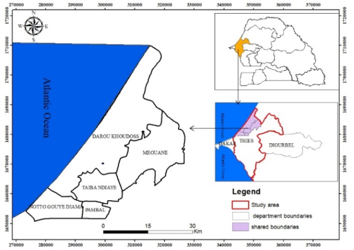
One of the eighteen communes in the Tivaouane department, Darou Khoudoss is an entity in the first horticultural region of Senegal: Thies, which provides 10 to 15% of the national production of market garden products. The commune of Darou Khoudoss takes its name from the village of Darou Khoudoss founded in 1962. During the creation of the village of Mboro in 2002, it was simultaneously designated as a rural community, which has now become a municipality with the Act III of decentralization in 2013. It is located in the northwest of the Tivaouane department, bordering the Atlantic Ocean with 65 km of maritime coastal fringe; it is part of the Meouane district (Figure 1). Like most of the communes in Senegal, it belongs to the Sudano-Sahelian climatic zone with two distinct seasons: a nine-month dry season (October-June) and a three-month rainy season (July-September) with a maximum rainfall in August. Darou Khoudoss includes 68 official villages which polarize more than a hundred hamlets (on-site survey). Spatially, the commune of Darou Khoudoss covers an area of 520 km2, with an average population density of 154 inhabitants per km2, and is bordered.
Figure 1. Location of the study area.
Darou Khoudoss became the administrative center of the commune during the division of the commune of Mboro in 2002. The town of Mboro thus saw the lands of five other villages amputated in favor of the new commune. And part of the Lompoul-sur-mer area annexed to Kebemer reduced the area of the commune from 548 km2 to 520 km2.
2.1. Climate and Temperatures
The climate is of the hot and dry Sahelian type with two seasons: a rainy season from June to October and a dry season from November to May . It is moderate and influenced by the circulation of maritime trade winds blown by the cold currents from the north (Azores). The differences are relatively small due, on the one hand, to the influence of the cold marine currents from the Canaries, the upwelling of cold deep ocean waters offshore and the predominance of the cool and humid maritime trade winds for a major part of the year. On the other hand, summer precipitation, cloudiness and high atmospheric humidity as well as lower temperatures . The warmest monthly average temperature fluctuates around 27.5°C and occurs in July and August. From November to February, the maximum temperature is below 28°C and the minimum temperature is below 18°C. In May and June, the presence of the harmattan can raise the temperature to a maximum of 31°C .
2.2. Precipitations
In this environment, a high relative humidity level can be noted, reaching 90% from April onwards . This humidity is exacerbated by Mboro's proximity to the ocean, just a few kilometers away. The study area is characterized by the alternation of two main seasons: a rainy season lasting two to three months (July, August, and September) and a dry season during the rest of the year. Rainfall is dictated by the presence of the monsoon from the south, originating from the Saint Helena High during the rainy season. It is not abundant and rarely exceeds 500 mm per year in its southern part and 350 mm in its northern part. Precipitation described as occult and called "heug" or "mango" rains often occurs during the dry season, particularly during the cold season (December, January, and February). These irregular and sparse precipitations, resulting from the intrusion of cold air masses, are counter-seasonal in this environment. Climate deterioration resulting from climate change has led to interannual irregularities in precipitation, as well as a decrease in precipitation volumes, resulting in a remarkable southward shift of the isohyets. Furthermore, the study area has been disrupted by drought cycles, particularly since the 1960s. However, since the 2000s, there has been a relative increase in the amount of water falling annually in the area, which is of great importance for agricultural practices.
2.3. Surface Waters
In this part of the Niayes region, there is an artificial lake that was created following the establishment of Industries Chimiques du Senegal (ICS). This area is also located near the Mboro coastline, about 5 km from the town of Darou Khoudoss.
2.4. The Nature of the Aquifer
West of the Thies road, the aquifer is composed of sandy and sandy clay deposits resting on the marl or marl-limestone substratum of the Tertiary . It is an important reservoir of water which flows slowly towards the ocean by gravity. Generally, of good quality, these waters are however sensitive to anthropogenic pollution especially if they are heavily exploited. This is the case of the Darou Khoudoss area with the intensive use of the resource by market gardeners and industries.
3. Sampling Methods
Samples were collected by pump from the three sources before being packaged in polyethylene bottles. In situ measurements were performed using a multiparameter probe, while cation and anion analyses were conducted using DIONEX ion chromatography.
4. Results
4.1. Physical Parameters
4.1.1. pH
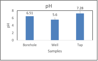
The measured pH values were 5.60 for well water, 6.51 for borehole water, and 7.28 for tap water (Figure 2). These results highlight the marked acidity of the well water, while the borehole water has a pH close to neutral and the tap water is characterized by a generally neutral to slightly basic reaction. Based on the reference range of 6.5 to 9.5 established by the World Health Organization (WHO), borehole and tap water meet the recommended values, unlike well water, whose pH is below the minimum threshold. These results thus suggest that well water and tap water are of higher quality in terms of pH and, as a result, appear to be more suitable for human consumption than well water.
Figure 2. PH variations.
4.1.2. Electrical Conductivity
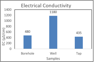
The values obtained for the electrical conductivity of the samples are respectively 480 for the borehole, 1180 for the well and 435 µS/cm for the tap (Figure 3). According to the World Health Organization standards standard, the interval not to be exceeded is 50 µS/cm and 1500 µS/cm, which shows that the water from the 3 samples can be consumed without risk by the households in the study area (Figure 3).
Figure 3. Electrical Conductivity variations.
4.2. Chemical Parameters
4.2.1. Calcium (Ca2+)
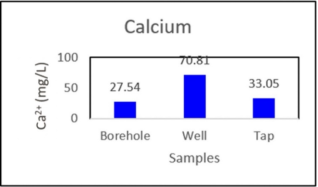
The calcium values in the results are respectively 27.54 mg/L for the borehole, 70.81 mg/L for the well and 33.05 mg/L for the tap (Figure 4). The World Health Organization standards standard does not establish threshold values for calcium. A high concentration of calcium in water is considered beneficial rather than dangerous, therefore the waters of the commune can be safely consumed by the populations of Darou Khoudoss.
Figure 4. Calcium variations.
4.2.2. Magnesium (Mg2+)
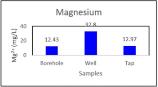
The magnesium values are respectively 12.43 for the borehole, 32.80 mg/L for the well and 12.97 mg/L for the tap (Figure 5). According to World Health Organization standards the magnesium concentration in drinking water should not exceed 50 mg/L. This shows that these waters can be intended for consumption by the inhabitants of the study area (Figure 5).
Figure 5. Magnesium variation.
4.2.3. Potassium (K+)
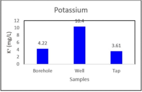
The potassium values in the analysis results are respectively 4.22 mg/L for the borehole, 10.4 mg/L for the well and 3.61 mg/L for the tap (Figure 6). Based on the World Health Organization standards standard for drinking water, the potassium content in drinking water should not exceed 12 mg/L, which proves that the population of Saraba can consume this water without health risks.
Figure 6. Nitrates variations.
4.2.4. Nitrates (NO3-)
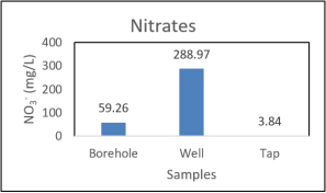
Nitrates are present in water by leaching of nitrogenous products in the soil, by decomposition of organic matter or synthetic or natural fertilizers . Nitrogen is an essential element in the construction of the cell. In the aquatic domain, nitrogen exists in molecular (N2) or ionized form: Nitrates (NO3-), Nitrites (NO2-) and ammonium (NH4+) as well as in dissolved or particulate organic form (protein, amino acids, urea, etc.) (These different forms of nitrogen are constantly evolving from one to the other through physicochemical and especially biochemical processes . Nitrates represent only one of the multiple forms of nitrogen present in water, while constituting, in general, the most abundant form of mineral nitrogen . Nitrate values at the various sampling points are: 59.26 for the borehole, 288.98 for the well, and 3.84 mg/L for the tap (Figure 7). According to the World Health Organization standards standard, the nitrate value for human consumption must not exceed 50 mg/L. Based on this standard, well and borehole water in the study area should not be consumed by households in Darou Khoudoss, but they may consume tap water.
Figure 7. Nitrates variations.
4.2.5. Chloride (Cl-)
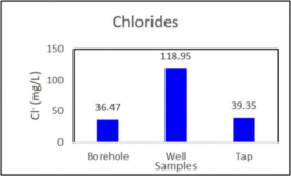
Chloride (Cl-) in water is an ion derived from chlorine, present in dissolved form. It comes from various natural and anthropogenic sources, and it plays several roles, both as a water quality indicator and as a chemical component influencing various environmental and industrial processes. The concentration of chloride in water also depends on the areas crossed . The chloride values are 36.47 for boreholes, 118.95 for wells, and 39.35 mg/L for taps, respectively (Figure 8). According to the World Health Organization standards, the amount of chloride in drinking water should not exceed 250 mg/L, which indicates that all three types of water can be consumed by the population of the municipality.
Figure 8. Chloride variations.
4.2.6. Sulfates (SO42-)
Sulfates (SO42-) originate from runoff or infiltration in gypsum soils. They also result from the activity of certain bacteria (chlorothiobacteria, rhodothiobacteria, etc.) . This activity can oxidize toxic hydrogen sulfide (H2S) into sulfate .
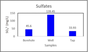
Figure 9. Sulfates variations.
The physicochemical analysis data for sulfate are 45.6 for the borehole, 139.45 for the well, and 33.93 mg/L for the tap, respectively (Figure 9). According to the World Health Organization standards standard, the sulfate value in drinking water must not exceed 500 mg/L, which therefore shows that the three water samples are suitable for consumption by the population of the Darou Khoudoss commune.
4.2.7. Bicarbonates (HCO3-)
Bicarbonate, or hydrogen carbonate, is a polyatomic ion with the chemical formula HCO3. Bicarbonate owes its prefix ("bi-") to its dual acid-base character (known as amphoteric character): it is both acid and base, belonging to two different acid-base pairs. It is the intermediate form in the double deportation of carbonic acid: removing the first proton (H*ion) from carbonic acid gives bicarbonate; removing the second proton gives the ionic carbonate form.
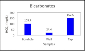
The bicarbonate values are 103.7 mg/L for boreholes, 24.4 mg/L for wells, and 152.5 mg/L for tap water, respectively (Figure 10). The World Health Organization standards has not set threshold values for bicarbonate concentration in water. However, the water can be consumed without health risks.
Figure 10. Bicarbonates variations.
4.2.8. Fluorine (F-)
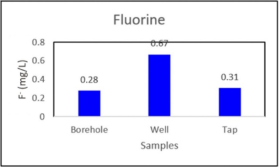
In the analysis results, the fluoride values are respectively 0.28 for the borehole, 0.67 for the well and 0.31 mg/L for the tap (Figure 11). According to the World Health Organization standards, the fluoride concentration should not exceed 1.5 mg/L. This therefore shows that these waters can be consumed safely by the populations of this study area.
Figure 11. Fluorine variations.
5. Discussions
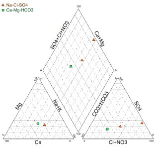
The Piper diagram highlights two main hydrochemical facies: Ca-Mg-HCO3 (calcium-magnesium bicarbonate facies) and Na-Cl-SO4 (sodium chloride-sulfate facies) (Figure 12).
Figure 12. Piper Diagramm.
The Ca-Mg-HCO3 facies corresponds to calcium-magnesium bicarbonate waters, generally linked to recharge areas mainly resulting from the dissolution of carbonate formations . On the other hand, the Na-Cl-SO4 facies represents highly mineralized waters, World Health Organization standards composition is influenced by cation exchanges, the dissolution of evaporites, evaporation processes, and, depending on the hydrogeological context, by salinization or human activities .
The correlation matrix between the physicochemical and chemical parameters of groundwater shows a strong correlation (r > 0.8) between the ions Cl-; SO42-, Na+, K+, Mg2+, Ca2+, F-, and Fe2+ and the electrical conductivity (Table 1). This strong correlation indicates that electrical conductivity is mainly controlled by the concentration of dissolved ionic species and is therefore an excellent indicator of the degree of groundwater mineralization.
Major ions also show very high positive correlations, revealing the existence of a common source of mineralization and/or similar geochemical processes. The strong correlations between sodium and sulfates (Na+-SO42-; r = 0.999), sodium and chlorides (Na+-Cl-; r = 0.986), potassium and sulfates (K+-SO42-; r = 1.000), potassium and sodium (K+-Na+; r = 0.999), as well as between chlorides and sulfates (Cl--SO42-; r = 0.991) (Table 1), indicate that these elements evolve simultaneously. This joint evolution can be attributed to hydrogeochemical processes such as mineral dissolution, water-rock interactions, ion exchanges, and, depending on the hydrogeological context, to natural salinization influence or inputs of anthropogenic origin . The strong correlation between calcium (Ca2+) and magnesium (Mg2+) shows a common origin for these two cations, mainly related.
Table 1. Correlation matrix.

pH

EC

HCO3-

Cl-

NO3-

SO42-

Na+

K+

Mg2+

Ca2+

F-

Fe2+

pH

1

CE

-0,912

1

HCO3-

0,996

-0,945

1

Cl-

-0,875

0,996

-0,914

1

NO3-

-0,958

0,992

-0,980

0,977

1

SO42-

-0,931

0,999

-0,959

0,991

0,997

1

Na+

-0,942

0,997

-0,968

0,986

0,999

0,999

1

K+

-0,923

1,000

-0,954

0,994

0,995

1,000

0,999

1

Mg2+

-0,878

0,997

-0,917

1,000

0,979

0,992

0,988

0,995

1

Ca2+

-0,829

0,985

-0,876

0,996

0,955

0,976

0,969

0,980

0,996

1

F-

-0,855

0,992

-0,898

0,999

0,968

0,986

0,979

0,989

0,999

0,999

1

Fe2+

-0,618

0,886

-0,685

0,922

0,818

0,863

0,846

0,873

0,919

0,952

0,936

1

6. Conclusions
This study focused on evaluating the drinking water quality in the Darou Khoudoss municipality, Saraba neighborhood, in the Tivaouane department in Senegal. To this end, three water samples were taken in September 2024 and then analyzed at the Hydrochemistry Laboratory of the Geology Department at UCAD. The results of the physicochemical analyses revealed: - Well water with an acidic pH, while borehole and tap water were alkaline, and electrical conductivity met the reference standard. - Groundwater parameters (Ca2+, Mg2+, Na+, K+, Fe2+, Cl-, HCO3-, F-, SO42-) were within limits except for NO3-, which was very high, exceeding the threshold set for human consumption. Tap water where all parameters were compliant with drinking water standards. Residents of the municipality would benefit more from drinking tap water than borehole or well water to maintain their health.
7. Recommendations
In light of the progressive deterioration of water quality in the boreholes and wells within the study area, a session was held to share the research findings with local communities and public authorities, aiming for better water resource management.
Abbreviations

Ca2+

Calcium Ion

SPCT

Senegalese Phosphate Company of Taiba

EC

Electrical Conductivity

F-

Fluorine Ion

Fe2+

Iron Ion

GCO

Grande Cote Operation

HCO3-

Bicarbonate Ion

H2S

Sulfur

K+

Potassium Ion

Km2

Square Kilometer

Mg2+

Magnesium Ion

mg/L

Milligram Per Liter

Na+

Sodium Ion

NH4+

Ammonium Ion

NO3-

Nitrate Ion

pH

Hydrogen Potential

SO42-

Sulfate Ion

UCAD

University Cheikh Anta Diop

µS/cm

Microsiemens Per Centimeter

WHO

World Health Organization

Author Contributions
Alassane Thiam: Conceptualization, Data curation, Resources, Supervision, Writing – original draft
Ahmed Dame Mboup: Data curation, Resources
Amadou Babacar Sarr: Resources, Visualization
Bidji Ba: Visualization
Conflicts of Interest
The authors declare no conflicts of interest.
References
[1] Alassane Thiam, Aziz Gning, and Issa Ndoye. (2020). “Groundwater Quality Assessment in the Coastal Quaternary Sandy Aquifer in Darou Thiam-Segoul Thioune-Fass Boye Axis (Niayes Area, Senegal) (2020). American Journal of Water Resources, vol. 8, no. 6 (2020): 246-255.
[2] Fall M., Niang S. & Sy B. A. (2022). The Niayes of the Northern Coast of Senegal: Formation Processes, Salinization of Groundwater and Soils. ESI Preprints.
[3] Ndioufa NDAW, Seydou Alassane SOW, Cheikh Ahmed Tidiane FAYE et Mouhamadou Lamine DIALLO, (2019). Mining extractive activities and horticulture in the Niayes of the Commune of Darou Khoudoss, Senegal-Africa SCIENCE 15(6) (2019) 130 - 142.
[4] Ngom, Mamadou (2007): Issue of pesticide use in the town of Mboro, Master's thesis, Department of Geography, UCAD.
[5] Ibra Faye, El Hadji Balla Dieye, Henri Marcel Seck, Djiby Yade, Fatou Faye (2026). Socio-ecological vulnerability and production systems in the Niayes of Senegal: multi-criteria geospatial analysis and sustainability prospects, European Scientific Journal, ESJ: Vol 22 No 20 (2026): ESJ Humanities.
[6] Sarr, Mariama (2016). Impacts of vegetable farming on local development: case of the Darou Khoudoss municipality. Master’s Thesis II, Department of Geography FLSH / UCAD, 95 pages.
[7] Fall, Safietou et Fall Abdou Salam (2001). Urban agriculture in the large Niayes of Senegal, Published by the Research Centre for International Development, P. O. Box 8500, Ottawa (Ontario), Canada K1G 3H9, March 2001, 120 pages.
[8] Kane, A. (2008): Action plan of the PNES (National Water Partnership of Senegal).
[9] Tine, Josephine, (2018). Mining (zircon) and the environment: risk to the water resources of the Diogo coast in the Commune of Darou Khoudoss in Senegal.
[10] Samake, Hawa, (2002). Physico-chemical and bacteriological analysis at the L. N. S of drinking water in the city of Bamako during the period 2000 and 2001, 77p.
[11] Belghiti M. L., Chahlaoui A., Bengoumi D., El Moustane R (2013). Study of the physico-chemical and bacteriological quality of groundwater from the Plio-Quaternary aquifer in the Meknès region (Morocco), 36 pages.
[12] Haut-Commissariat aux Eaux et Foret et la Lutte contre la desertification, (HCEFLCD). (2006). Etude sur la pisciculture au barrage Amassera, CR dar CHAFAAI, Cercle d'ELBROUGE, Province de Settat, 201p.
[13] Al Haj, R., Merheb, M., Halwani, J., & Ouddane, B. (2025). Baseline hydro-geochemical characteristics of groundwater in Abu Ali watershed (Northern Lebanon). Vol 57.
[14] Appelo, C. A. J., Postma, D. (2005). Geochemistry, Groundwater and Pollution. Second Ed, Balkema, Rotterdam, 656p.
[15] An, G., Kang, H., Fu, R., Xu, D., & Li, J. (2023). Investigation on the hydrogeochemical characteristics and controlling mechanisms of groundwater in the coastal aquifer. Water, 15(9), 1710.
Cite This Article
  • APA Style

    Thiam, A., Mboup, A. D., Sarr, A. B., Ba, B. (2026). Assessment of the Quality of Drinking Water in Saraba Neighborhood in Darou Khoudoss (Thies, Senegal). American Journal of Water Science and Engineering, 12(4), 116-123. https://doi.org/10.11648/j.ajwse.20261204.12

    Copy | Download

    ACS Style

    Thiam, A.; Mboup, A. D.; Sarr, A. B.; Ba, B. Assessment of the Quality of Drinking Water in Saraba Neighborhood in Darou Khoudoss (Thies, Senegal). Am. J. Water Sci. Eng. 2026, 12(4), 116-123. doi: 10.11648/j.ajwse.20261204.12

    Copy | Download

    AMA Style

    Thiam A, Mboup AD, Sarr AB, Ba B. Assessment of the Quality of Drinking Water in Saraba Neighborhood in Darou Khoudoss (Thies, Senegal). Am J Water Sci Eng. 2026;12(4):116-123. doi: 10.11648/j.ajwse.20261204.12

    Copy | Download

  • @article{10.11648/j.ajwse.20261204.12,
      author = {Alassane Thiam and Ahmed Dame Mboup and Amadou Babacar Sarr and Bidji Ba},
      title = {Assessment of the Quality of Drinking Water in Saraba Neighborhood in Darou Khoudoss (Thies, Senegal)},
      journal = {American Journal of Water Science and Engineering},
      volume = {12},
      number = {4},
      pages = {116-123},
      doi = {10.11648/j.ajwse.20261204.12},
      url = {https://doi.org/10.11648/j.ajwse.20261204.12},
      eprint = {https://article.sciencepublishinggroup.com/pdf/10.11648.j.ajwse.20261204.12},
      abstract = {Senegal, like all other developing countries, faces problems with access to drinking water. This study focused on evaluating the quality of drinking water in the Saraba neighborhood within the commune of Darou Khoudoss in the Thies region. The methodology involved collecting water samples from wells, boreholes, and taps, followed by physico-chemical analyses (T, pH, Electrical Conductivity, Ca2+, Mg2+, Na+, K+, Fe2+, NO3-, SO42-, HCO3-, Cl-, F-) at the Hydrochemistry Laboratory of the Department of Geology at the Faculty of Science and Technology of Cheikh Anta Diop University in Dakar. The results show pH values for the well (5.60) and nitrate levels for the borehole (59.26 mg/L) and the well (288.97 mg/L) that are non-compliant. The analysis results show that a few parameters, namely the pH and nitrate content of the well and borehole, do not meet World Health Organization standards. NO3- ions have exceeded the threshold for human consumption (50 mg/l), which could be due to heavy agricultural activity in the area, but this water (well and borehole) can still be used for irrigation since it is used for making fertilizer. The well water has a high acidity level, which may render it unfit for human consumption. In general, water from wells and boreholes has characteristics that could expose local populations to health risks, underscoring the need for regular monitoring of their physicochemical and microbiological quality.},
     year = {2026}
    }
    

    Copy | Download

  • TY  - JOUR
    T1  - Assessment of the Quality of Drinking Water in Saraba Neighborhood in Darou Khoudoss (Thies, Senegal)
    AU  - Alassane Thiam
    AU  - Ahmed Dame Mboup
    AU  - Amadou Babacar Sarr
    AU  - Bidji Ba
    Y1  - 2026/10/20
    PY  - 2026
    N1  - https://doi.org/10.11648/j.ajwse.20261204.12
    DO  - 10.11648/j.ajwse.20261204.12
    T2  - American Journal of Water Science and Engineering
    JF  - American Journal of Water Science and Engineering
    JO  - American Journal of Water Science and Engineering
    SP  - 116
    EP  - 123
    PB  - Science Publishing Group
    SN  - 2575-1875
    UR  - https://doi.org/10.11648/j.ajwse.20261204.12
    AB  - Senegal, like all other developing countries, faces problems with access to drinking water. This study focused on evaluating the quality of drinking water in the Saraba neighborhood within the commune of Darou Khoudoss in the Thies region. The methodology involved collecting water samples from wells, boreholes, and taps, followed by physico-chemical analyses (T, pH, Electrical Conductivity, Ca2+, Mg2+, Na+, K+, Fe2+, NO3-, SO42-, HCO3-, Cl-, F-) at the Hydrochemistry Laboratory of the Department of Geology at the Faculty of Science and Technology of Cheikh Anta Diop University in Dakar. The results show pH values for the well (5.60) and nitrate levels for the borehole (59.26 mg/L) and the well (288.97 mg/L) that are non-compliant. The analysis results show that a few parameters, namely the pH and nitrate content of the well and borehole, do not meet World Health Organization standards. NO3- ions have exceeded the threshold for human consumption (50 mg/l), which could be due to heavy agricultural activity in the area, but this water (well and borehole) can still be used for irrigation since it is used for making fertilizer. The well water has a high acidity level, which may render it unfit for human consumption. In general, water from wells and boreholes has characteristics that could expose local populations to health risks, underscoring the need for regular monitoring of their physicochemical and microbiological quality.
    VL  - 12
    IS  - 4
    ER  - 

    Copy | Download

Author Information