Research Article | | Peer-Reviewed

Geospatial Based Dam Potential Site Selection in the Catchment Area of Beressa River, Debre Berhan, Ethiopia

Received: 18 October 2024     Accepted: 8 November 2024     Published: 28 November 2024
Views:       Downloads:
Abstract

Choosing a suitable site for dam is a crucial phase in dam construction. A successful outcome of this effort is initiated by taking into consideration some watershed properties and characteristics. The objective of this study was to determine suitable sites for dam construction along Beresa River Watershed of Debre Berhan town, Ethiopia. The method used was based on consideration of seven criteria which included topographic factors (slope), geological factors, soil type, catchment size, and land cover, proximity to river and proximity to roads using geospatial tools. Each factor was standardized to a common measurement scale so that the results represent numeric range giving higher values to more suitable and lower values to less suitable attributes. Weighted overlay analysis was applied to obtain layers showing suitable sites for dam construction. The final suitability map of the study area shows that from the total area, 0.53ha (0.01%) was mapped in most suitable, 0.35ha (0.01%) in more suitable, 1.32ha (0.02%) in suitable, 0.33ha (0.01%) in less suitable and 5708.47ha (99.96%) unsuitable for dam site selection and construction. The study proved that, the system will provide reliable and easy system for dam site selection and construction in the study area.

Published in American Journal of Remote Sensing (Volume 12, Issue 2)
DOI 10.11648/j.ajrs.20241202.12
Page(s) 46-52
Creative Commons

This is an Open Access article, distributed under the terms of the Creative Commons Attribution 4.0 International License (http://creativecommons.org/licenses/by/4.0/), which permits unrestricted use, distribution and reproduction in any medium or format, provided the original work is properly cited.

Copyright

Copyright © The Author(s), 2024. Published by Science Publishing Group

Keywords

GIS, Weighted Overlay, Suitability Analysis, Beresa River, AHP, Weighted Overlay

1. Introduction
Water is a crucial element for the survival of life on earth . With urban development and its associated growing population with its ever-increasing demand , water scarcity has been significantly increasing. Water consumption per capita has reached 550 L/day in some countries due to modern lifestyles, a development which places an additional pressure on existing water resources . Developing countries are more vulnerable to water scarcity compared with the developed ones. The main obstacles developing countries face include unplanned urbanization, limited water resources and ineffective regulations for managing water supply and distribution. Therefore, managing water resources and identifying unconventional methods to store and supply water are strategic priorities for any .
Nevertheless, Ethiopia remains a state of water insecurity and scarcity which can be epitomized by Ethiopian proverb “የአባይን ልጅ ዉሃ ጠማዉ” ‘the daughter of Nile got thirsty’. Therefore, construction of dam is a crucial solution to the problem of water scarcity for both residential and irrigation uses, which is caused mostly by low rainfall and longer dry seasons, resulting in droughts. For this, research to be effective, the primary focus should be on locating a good site for the dam. The critical problem is determining an effective, efficient, and accurate approach for dam site selection that will give correct terrain analysis and appropriate information on the chosen site for good planning and design .
The usage of GIS and AHP Multi-Criteria Decision Analysis was selected in this study as a feasible method of making optimum selections when identifying a suitable dam location. GIS sables to acquire, store, retrieve, modify, and analyze data were important concerns, whereas AHP Multi-Criteria Decision Analysis skills coupled geographic data with decision maker preferences to provide alternative conclusions . The watershed parameters, such as slope, soil, geology, land cover, and catchment, as well as social-economic variables, such as proximity to a road and proximity to a river, must all be taken into account when choosing a good site for an earth dam . The most relevant aspects are the slope and the characteristics of the area, since these govern the inundation behavior of the area in the study .
Remote sensing and GIS techniques application in hydrology are the utmost effective methodologies , which provides valuable datasets for examining hydrological variables and morphological changes for small, medium and large regions at different scales both spatial and . GIS significantly enhances the value of spatial analysis in land use administration as well as automatic delineation of drainage systems and fundamental catchments , and also it will provide layers dedicated for each factor in which weighting is done in AHP Multi-Criteria Decision Analysis, determination of suitable sites for dam construction is done. The main objective of the study of this sub thematic area is to select, optimum site for dam designing and Reservoir coverage area using GIS techniques. The specific Objectives of this study are to assess the whole study area of catchment and gather geographical information, to identify the major factors and constraints for locating a suitable dam site in the case study area and to prepare a map shows the optimal dam site in the study area.
2. Materials and Method Used
2.1. Software’s
It is ArcGIS software and its extensions that is mainly used in addition to some others that are used rarely for minor purposes such as Google Earth, Global Mapper, AutoCAD, Spectrum and Sokkia Link and DNR Garmin for uploading spatial information and conversion purposes, Notepad (MS excel) for further viewing, editing and arranging the spatial data of GPS whenever needed.
2.2. Equipment’s and Tools
Total station, Level Instrument and GPS were among main Equipment’s used for collecting the spatial (locational) information that helps determine the horizontal and vertical controls, distance, area and boundaries of the study area. Computer is also a machine that is most commonly used for data processing and the final output preparation. In this study, mostly laptop computer used due to several reasons of which one and very important is that it is portable and comfortable in handling and data storage, processing, analysis and further preparation of the final output. Secondly the researchers can take it where ever wanted during data gathering period. The other behind is that laptop computer is more accessible to the researcher than the desktop computer.
Table 1. List of Materials used.

Hardware

No

Name

Company

Purpose/for

1

GPS

Garmin

Establishment and Identifying horizontal and vertical controls

Total station

Sokkia

Collecting the horizontal and vertical control points

Level

Sokkia

Measuring the vertical distance of a point above mean sea level

Software

2

DNR Garmin

Garmin

Downloading the collected data

AutoCAD (version 2007)

Autodesk

Plotting and exporting data into GIS

ArcGIS (version 10.5)

ESRI

building geo-database and analysis

2.3. Methods
After collecting all Materials and data that enables the output to be achieved, different methods were used for processing inputs and to meet the objectives.
Therefore, the study used the above tabulated data using Geospatial tools to come up with the findings. The primary data source was gathered through Garmin GPS for the purpose of delineating the catchment size of the river. By doing this; the researchers were calculated the catchment area to select the optimal site of the dam. Moreover, the secondary data source dada was converted into the appropriate file format and imported into GIS environment for the purpose of defining projection, geo-referencing, extracting data for further analysis. Using spatial analysis tool, the overall process was performed to select the optimal dam site as indicated below in the model.
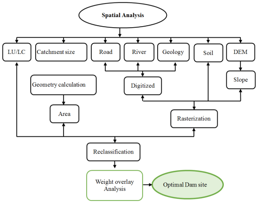
Figure 1. Technological Schemes of Optimal Dam Site Selection for Beressa River.
3. Analysis, Result and Discussion
3.1. Analysis
The overlay inputs were all the layers standardized into a common scale of 1 to 5, with 5 being the most favorable as shown in Figure 9. By using the Weighted Sum tool in ArcGIS, each input raster is multiplied by the specified weight. It then overlays all input raster layers together to obtain the final suitability map (Figure 9) The map was reclassified into five suitability classes. Values must be prioritized even within a single raster. This is because values in a particular raster may be fit for your purpose while others may be undesirable (ESRI, 2017). For example a slope of 0% - 9% is ideal for dam site selection. This was done through a process of reclassification in ArcGIS environment. To perform the reclassification, each raster dataset was reclassified into a common scale of 1 to 5. With 5 being more favorable hence has the highest influence for dam site selection and 1 with the lowest influence.
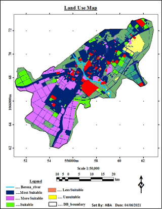
Figure 2. Land use suitability map.
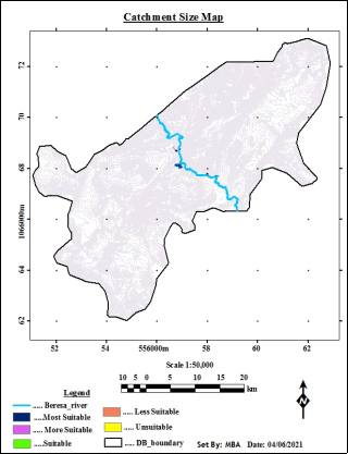
Figure 3. Catchment size suitability map.
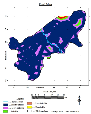
Figure 4. Road suitability map.
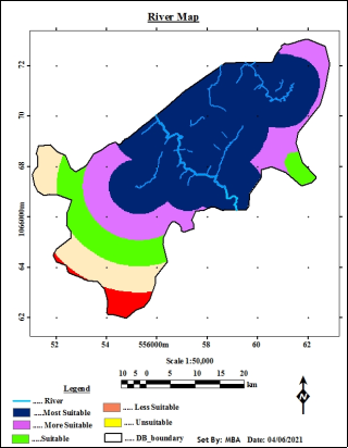
Figure 5. River suitability map.
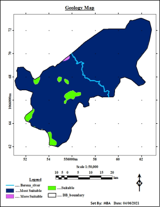
Figure 6. Geology suitability map.
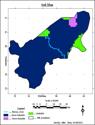
Figure 7. Soil suitability map.
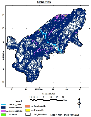
Figure 8. Slope suitability map.
3.2. Result
3.2.1. Assigning Weights of Importance
In this study, all the reclassified criteria were combined to determine suitable solid waste dumping sites in the case study area according to their degree of importance. Because they have varying importance, each criterion must be evaluated on the basis of its relative importance. In this study, weights for the criteria used to select solid waste dumping sites were assigned and standardized based on the Analytical Hierarchy Process (AHP) which is developed by using pairwise comparison matrix. The pairwise comparison can be implemented in a spread sheet environment and it considers only two criteria at a time (Kirkwood, 1997). Most GIS-based decision making problems now incorporate the pairwise comparison method into their procedures . The consistency ratio (CR) of the matrix is then computed from the weights obtained to ascertain the consistency.
3.2.2. Weighted Overlay Analysis
Weighted overlay analysis is a process of combining all the standardized and weighted criteria used in the analysis to get the intended outcomes. These pairwise comparisons were then analysed to produce a set of weights that sum to 1. The factors and their resulting weights can be used as input for the MCE module for weighted linear combination or ordered weighted average (or the scalar and overlay modules). Accordingly, pair-wise comparison matrix was created by assigning weights according to the respective significance of contributing factors for dam site selection. The weights are further evaluated in finding alternatives and estimating associated absolute numbers from 1 to 9 in fundamental scales of the AHP. These weights were computed automatically in Idrisi32 as Data Entry/Edit Factors/Save as type /Pairwise comparison (.*pcf)/close Edit dialog box then point to GIS Analysis/Decision Support/weight/browse previous pairwise comparison files/next/calculate weight analysis.
Table 2. Eigenvector of Weights of the Pair-wise Comparison Matrix.

S/No

Criteria

Weights

% of weight

1

Slope

0.3680

37

2

Geology

0.3005

30

3

Soil

0.1363

14

4

catchment size

0.0983

10

5

Land use

0.0436

4

6

Proximity to river

0.0287

3

7

proximity to road

0.0245

2

Total

1

100

3.2.3. Ranking Potential Sites
Table 4 and figure 9 showed that, ranking of potential sites based on suitability of gentle slope, stronger foundation of geology, soil infiltration rate, largest catchment size, urban agriculture land use land cover type and accessibility to rivers as well as roads. Accordingly, potential site 1 indicated in green colour was ranked first which is highly suitable followed by 2, 3, 4 and 5 ranked as suitable, moderately suitable, less suitable and unsuitable respectively.
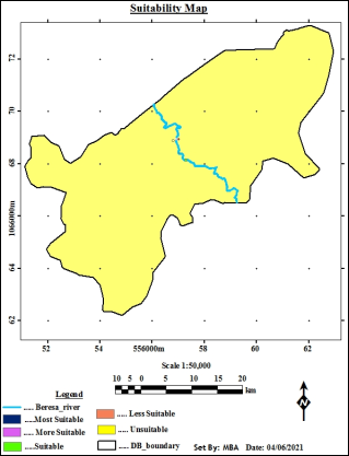
Figure 9. Suitability map of Debre Berhan Town.
Table 3. Ranking of Most Suitable Sites.

Sites

Ranking

Suitability

Land use type

Area (ha)

Area (%)

Colors

1

1st

most suitable

Urban agriculture

0.53

0.01

Dark blue

2

2nd

More Suitable

Forest

0.35

0.01

Pink

3

3rd

suitable

Recreational area

1.32

0.02

Green

4

4th

Less suitable

Formal green

0.33

0.01

Red

5

5th

Unsuitable

Residence, commerce, storage, manufacturing

5708.47

99.96

Yellow

Total

5711

100

3.3. Discussion
Based on the literature survey, it can be noted that before the year 2000, the selection criteria employed for selection of suitable dam site were based on biophysical factors only. From 2000, the selection criteria began to include socio-economic factor along with biophysical characteristics. Socio-economic factor are important issue since it offers the linkage of management of water to economic and social welfare. The biophysical criteria used are quite similar, but the socio-economic criterion differs. The most common biophysical criteria were slope, geology, and soil type and catchment size respectively. Slope plays a very significant role in selecting dam potential site for construction. The socio-economic factors employed in this study were less economic value of land use land cover type, proximity to river and proximity to road. Selection of these criteria depends on insight knowledge of local situation and stakeholders involved, access to data on costs and benefits and social parameters such as availability of labours, land and water rights and risk of flooding.
4. Conclusion
According to the findings, combining GIS with AHP Multi-Criteria Decision Analysis was successful in establishing hydrological information for the region, which guided in arriving at acceptable dam site locations. As a result, both are capable and helpful decision-making tools. The results show that integrating GIS with AHP Multi-Criteria Decision Analysis for dam site selection is both possible and effective. Dam site selection is influenced by biophysical factor such as soil type, rainfall, tectonic, geomorphic, slope, catchment area and socio-economic factors. The suitability map showed that, a total area of 0.53ha (0.0.01%) was classified most suitable, 0.35ha (0.01 %) of total town coverage was considered more Suitable, 1.32ha (0.02 %) suitable, 0.33 ha (0.01%) less suitable and 5708.47ha representing (99.96 %) were found unsuitable for selecting suitable dam. In general, the findings of this study conclude by ranking potential sites of the study area. Accordingly, potential site 1 was ranked first as most suitable site because of because of slope and geology formation and accessible to road networks and fulfilled norms and standards employed in this analysis. Likewise, potential sites followed by 2, 3, 4 and 5 ranked as more suitable, suitable, less suitable and unsuitable respectively. The study proved that, GIS based and Spatial MCE methods were a powerful tool in handling large amounts of data and narrowing areas of interest for potential dam site selection in the case study area. This study provides a reference for future GIS based dam site selection especially in areas where integration of GIS with Multi-Criteria Decision Analysis for a dam site selection is yet to be implemented.
Abbreviations

GIS

Geographical Information System

MCE

Multi Criteria Evaluation

AHP

Analytical Hierarchy Process

LULC

Landuse Landcover

GPS

Global Positioning System

Author Contributions
Bedasa Asefa is the sole author. The author read and approved the final manuscript.
Conflicts of Interest
The author declares no conflicts of interest.
References
[1] Ghazal, N. K. and Salman, S. R.. (2015). Determining the Optimum Site of Small Dams Using Remote Sensing Techniques and GIS. International Journal of Scientific Engineering and Research (IJSER), 3, 69-73.
[2] Government of Western Australia. (2014). Dam Construction and Operation in Rural Areas. Water Quality Protection Note 53 Rural Dams, 1-27.
[3] Hoekstra, A. Y.; Chapagain, A. K. (2007). Water footprints of nations: Water use by people as a function of their consumption pattern.
[4] Kassaye Hussien, Gezahagn Woldu and Shimelis Birhanu. (2019). A GIS-Based Multi-Criteria Land Suitability Analysis for Surface Irrigation along the Erer Watershed, Eastern Hararghe Zone, Ethiopia.
[5] M Rafiqul Islam, Munshi Rashid Ahmad, Muhammad Nurul Alam, Mong Sanue Marma, Abdul Gafur. (2020). Micro-watershed Delineation and Potential Site Selectionfor Runoff Water Harvesting Using Remote Sensing andGIS in a Hilly Area of Bangladesh. American Journal of Water Resources.
[6] Munyao, J. N. (2010). Use of Satellite Products to Assess Water Harvesting Potential in Remote Areas of Africa: A Case Study of Unguja Island. Enschede, The Netherlands.
[7] Njiru, F. M. and Siriba, D. N. (2018). Site Selection for an Earth Dam in Mbeere North, Embu County—Kenya. Journal of Geoscience and Environment Protection, 6, 113-133.
[8] Pimentel, D. and Burgess, M. (2013). Soil Erosion Threatens Food Production. Agriculture, 3, 443-463. Retrieved from
[9] Queensland. (2017). Environmental Factors That Influence Site Selection.
[10] Saaty. T, L. (2008). Decision making with the analytic hierarchy process. International Journal Services Sciences, 1:1, p. 83-89.
[11] Thanoon, H. A. and Ahmed, K. A.. (2013). Hydrological Information Extraction for Dams Site Selection Using Remote Sensing Techniques and Geographical Information System. Al-Rafidain Engineering, 21, 102-114.
[12] Veldkamp, T. I. E.; Wada, Y.; Aerts,. (2017). Water scarcity hotspots travel downstream due to human interventions in the 20th and 21st century.
Cite This Article
  • APA Style

    Asefa, B. (2024). Geospatial Based Dam Potential Site Selection in the Catchment Area of Beressa River, Debre Berhan, Ethiopia. American Journal of Remote Sensing, 12(2), 46-52. https://doi.org/10.11648/j.ajrs.20241202.12

    Copy | Download

    ACS Style

    Asefa, B. Geospatial Based Dam Potential Site Selection in the Catchment Area of Beressa River, Debre Berhan, Ethiopia. Am. J. Remote Sens. 2024, 12(2), 46-52. doi: 10.11648/j.ajrs.20241202.12

    Copy | Download

    AMA Style

    Asefa B. Geospatial Based Dam Potential Site Selection in the Catchment Area of Beressa River, Debre Berhan, Ethiopia. Am J Remote Sens. 2024;12(2):46-52. doi: 10.11648/j.ajrs.20241202.12

    Copy | Download

  • @article{10.11648/j.ajrs.20241202.12,
      author = {Bedasa Asefa},
      title = {Geospatial Based Dam Potential Site Selection in the Catchment Area of Beressa River, Debre Berhan, Ethiopia
    },
      journal = {American Journal of Remote Sensing},
      volume = {12},
      number = {2},
      pages = {46-52},
      doi = {10.11648/j.ajrs.20241202.12},
      url = {https://doi.org/10.11648/j.ajrs.20241202.12},
      eprint = {https://article.sciencepublishinggroup.com/pdf/10.11648.j.ajrs.20241202.12},
      abstract = {Choosing a suitable site for dam is a crucial phase in dam construction. A successful outcome of this effort is initiated by taking into consideration some watershed properties and characteristics. The objective of this study was to determine suitable sites for dam construction along Beresa River Watershed of Debre Berhan town, Ethiopia. The method used was based on consideration of seven criteria which included topographic factors (slope), geological factors, soil type, catchment size, and land cover, proximity to river and proximity to roads using geospatial tools. Each factor was standardized to a common measurement scale so that the results represent numeric range giving higher values to more suitable and lower values to less suitable attributes. Weighted overlay analysis was applied to obtain layers showing suitable sites for dam construction. The final suitability map of the study area shows that from the total area, 0.53ha (0.01%) was mapped in most suitable, 0.35ha (0.01%) in more suitable, 1.32ha (0.02%) in suitable, 0.33ha (0.01%) in less suitable and 5708.47ha (99.96%) unsuitable for dam site selection and construction. The study proved that, the system will provide reliable and easy system for dam site selection and construction in the study area.
    },
     year = {2024}
    }
    

    Copy | Download

  • TY  - JOUR
    T1  - Geospatial Based Dam Potential Site Selection in the Catchment Area of Beressa River, Debre Berhan, Ethiopia
    
    AU  - Bedasa Asefa
    Y1  - 2024/11/28
    PY  - 2024
    N1  - https://doi.org/10.11648/j.ajrs.20241202.12
    DO  - 10.11648/j.ajrs.20241202.12
    T2  - American Journal of Remote Sensing
    JF  - American Journal of Remote Sensing
    JO  - American Journal of Remote Sensing
    SP  - 46
    EP  - 52
    PB  - Science Publishing Group
    SN  - 2328-580X
    UR  - https://doi.org/10.11648/j.ajrs.20241202.12
    AB  - Choosing a suitable site for dam is a crucial phase in dam construction. A successful outcome of this effort is initiated by taking into consideration some watershed properties and characteristics. The objective of this study was to determine suitable sites for dam construction along Beresa River Watershed of Debre Berhan town, Ethiopia. The method used was based on consideration of seven criteria which included topographic factors (slope), geological factors, soil type, catchment size, and land cover, proximity to river and proximity to roads using geospatial tools. Each factor was standardized to a common measurement scale so that the results represent numeric range giving higher values to more suitable and lower values to less suitable attributes. Weighted overlay analysis was applied to obtain layers showing suitable sites for dam construction. The final suitability map of the study area shows that from the total area, 0.53ha (0.01%) was mapped in most suitable, 0.35ha (0.01%) in more suitable, 1.32ha (0.02%) in suitable, 0.33ha (0.01%) in less suitable and 5708.47ha (99.96%) unsuitable for dam site selection and construction. The study proved that, the system will provide reliable and easy system for dam site selection and construction in the study area.
    
    VL  - 12
    IS  - 2
    ER  - 

    Copy | Download

Author Information