Abstract
This study characterized and compared the spatiotemporal dynamics of animal and livestock disease frequency in Shashemene District, West Arsi, Oromia, Ethiopia. The work aimed to quantify spatial and temporal disease distributions, classify events into sporadic, endemic, epidemic, and pandemic-candidate patterns, estimate key epidemiological parameters including incidence and effective reproduction numbers (Re), and identify environmental and connectivity-related drivers of transmission. A retrospective spatiotemporal observational design was applied, synthesizing five to ten years of surveillance, laboratory, and farmer-reported data from district records over the period 2014 to 2023. A total of 500 recorded disease events across cattle, sheep, goats, poultry, and equids were analyzed at kebele-level resolution using Bayesian hierarchical modeling integrated with Geographic Information Systems and time-varying Re estimation. The analysis demonstrated that disease events were significantly concentrated during the wet season, accounting for 64.2% of cases, compared to 35.8% during the dry season. Sheep pox, 19.8%, and lumpy skin disease, 18.2%, consistently emerged as the most frequent conditions. Epidemic patterns were strongly associated with livestock movement and market connectivity, with odds ratios ranging from 1.78 to 2.12 and Re values peaking at 2.05 in high-traffic trade corridors, compared to Re = 1.52 in lower-frequency areas. Endemic patterns were linked to high animal density, limited veterinary infrastructure, and restricted access to services. Environmental drivers, particularly rainfall and temperature, showed a positive correlation with disease incidence, r = 0.324, especially for vector-borne and soil-borne pathogens. Overall, the findings established livestock mobility, seasonal climatic variability, and network connectivity as the principal drivers of disease dynamics in the district. The study concluded that transitioning from reactive responses to proactive, climate-sensitive, and network-informed interventions was critical to reducing disease burden and strengthening evidence-based veterinary public health policy.
Keywords
Disease Dynamics, Spatiotemporal Analysis, Livestock Mobility, Epidemiological, Surveillance, Shashemene District
1. Introduction
1.1. Background
Livestock production constitutes a foundational pillar of rural livelihoods, food security, and socioeconomic resilience across Ethiopia, particularly within the Oromia Region. In Shashemene District, mixed crop–livestock systems dominate the agrarian landscape, with cattle, small ruminants, poultry, and equids contributing directly to household income generation, nutritional security, draft power, and manure-based soil fertility
| [13] | Food and Agriculture Organization, FAO, (2020). Livestock production systems in Ethiopia: Characterization and analysis. Working Paper. |
[13]
. However, these benefits are persistently undermined by infectious animal diseases, which reduce productivity, increase mortality, disrupt market participation, and generate substantial indirect economic losses through trade restrictions and control measures
| [10] | FAO/ WOAH. (2021). Priority transboundary animal diseases: Global strategic framework for control. Food and Agriculture Organization of the United Nations & World Organization for Animal Health. |
| [27] | Molia, S., Boly, I. A., Duboz, R., Coulibaly, B., Guitian, J., Grosbois, V., Fournié, G., & Pfeiffer, D. U. (2021). Livestock trading networks and disease transmission in Tanzania and Uganda. PLOS ONE, 16(12). |
[10, 27]
.
Shashemene District represents a highly informative epidemiological setting due to the confluence of ecological heterogeneity, livestock mobility, and market connectivity. The district spans multiple agro-ecological zones characterized by seasonal rainfall variability, shifting land-use patterns, and heterogeneous grazing systems
| [17] | Gilbert, M., Nicolas, G., Belkhir, K., Vanwambeke, S. O., Robinson, T. P., & Wint, W. (2020). Mapping the spread of Foot-and-Mouth Disease and Peste des Petits Ruminants in East Africa. Nature Communications, 11(1), 2145. |
[17]
. Communal grazing areas, seasonal transhumance, informal livestock trade routes, and uneven veterinary service coverage create spatially and temporally variable exposure landscapes that favor diverse disease transmission pathways
| [13] | Food and Agriculture Organization, FAO, (2020). Livestock production systems in Ethiopia: Characterization and analysis. Working Paper. |
| [34] | Smith, J. M., Smith, G., & Shelling, E. (2019). Livestock mobility and communal grazing landscapes: Exposure pathways for infectious diseases. Landscape Ecology, 34(8), 1821–1836. |
[13, 34]
. Climatic drivers such as rainfall seasonality and temperature interact with vector ecology, host susceptibility, and environmental persistence of pathogens, further shaping disease dynamics
| [18] | Grace, D., Mutua, F., Ochungo, P., Kruska, R., Jones, K., Brierley, L., Lapar, L., Said, M., Herrero, M., Phuc, P. M., Thallo, N. B., & Pelas, I. S. (2019). Agro-ecological zones and infectious disease dynamics in Ethiopian livestock. Tropical Animal Health and Production, 51(6), 1435–1448. |
| [30] | Riley, S. (2007). Large-scale spatial-temporal dynamics of infectious diseases. Science, 316(5829), 1298–1301. |
[18, 30]
.
Against this backdrop, animal disease events in Shashemene manifest along a continuum of frequency and scale, ranging from isolated sporadic cases to persistent endemicity, episodic epidemics, and, in rare but consequential circumstances, transboundary or pandemic-type spread. Distinguishing among these patterns is not merely semantic; it is operationally decisive. Surveillance intensity, intervention timing, resource allocation, and policy responses depend critically on whether a disease is behaving as sporadic noise, entrenched endemic burden, an emerging epidemic, or a system-wide threat with long-distance propagation potential
| [2] | Anderson, R. M., & May, R. M. (1991). Infectious diseases of humans: Dynamics and control. Oxford University Press. |
| [10] | FAO/ WOAH. (2021). Priority transboundary animal diseases: Global strategic framework for control. Food and Agriculture Organization of the United Nations & World Organization for Animal Health. |
| [23] | Keeling, M. J., & Rohani, P. (2008). Modeling infectious diseases in humans and animals. Princeton University Press. |
[2, 10, 23]
.
This study was motivated by the need to move beyond descriptive reporting of animal disease events toward a quantitative, spatially explicit, and reproducible classification of disease frequency patterns. By integrating surveillance, abattoir, serological, and farmer-reported data with geographic information systems (GIS), time-series analyses, and epidemiological modeling, the study positioned Shashemene District as a meso-scale case study for understanding how local disease processes interfaced with regional connectivity and global transboundary risks.
1.2. Problem Statement
Despite the recognized importance of livestock to livelihoods and regional food systems in Shashemene District, animal disease
surveillance and response remain largely reactive, fragmented, and weakly informed by spatiotemporal epidemiological evidence
| [2] | Anderson, R. M., & May, R. M. (1991). Infectious diseases of humans: Dynamics and control. Oxford University Press. |
[2]
. Current animal health reporting systems primarily emphasize case notification and outbreak confirmation, but they rarely differentiate systematically between sporadic events, entrenched endemic transmission, short-term epidemics, and wider transboundary or pandemic-candidate dynamics
| [10] | FAO/ WOAH. (2021). Priority transboundary animal diseases: Global strategic framework for control. Food and Agriculture Organization of the United Nations & World Organization for Animal Health. |
[10]
. This lack of differentiation constrains the ability of veterinary authorities to calibrate surveillance intensity, prioritize interventions, and allocate limited resources proportionately to epidemiological risk.
In practice, diseases with fundamentally different transmission dynamics are often managed using uniform control approaches, leading to inefficiencies and missed opportunities for prevention. Sporadic cases may trigger disproportionate responses, while endemic diseases with substantial cumulative burden remain under-prioritized
| [27] | Molia, S., Boly, I. A., Duboz, R., Coulibaly, B., Guitian, J., Grosbois, V., Fournié, G., & Pfeiffer, D. U. (2021). Livestock trading networks and disease transmission in Tanzania and Uganda. PLOS ONE, 16(12). |
[27]
. On the contrary, early epidemic signals may go undetected because routine surveillance systems are not analytically structured to identify statistically significant deviations from expected baselines or emerging space-time clusters
| [23] | Keeling, M. J., & Rohani, P. (2008). Modeling infectious diseases in humans and animals. Princeton University Press. |
[23]
. This is particularly problematic in settings such as Shashemene, where livestock movement through markets, communal grazing, and seasonal transhumance can rapidly amplify transmission once critical thresholds are exceeded
| [13] | Food and Agriculture Organization, FAO, (2020). Livestock production systems in Ethiopia: Characterization and analysis. Working Paper. |
| [34] | Smith, J. M., Smith, G., & Shelling, E. (2019). Livestock mobility and communal grazing landscapes: Exposure pathways for infectious diseases. Landscape Ecology, 34(8), 1821–1836. |
[13, 34]
. A further challenge lies in the limited integration of spatial, temporal, and mechanistic epidemiological frameworks within district-level animal health decision-making. While surveillance data are routinely collected, they are seldom analyzed using spatial autocorrelation metrics, space-time scan statistics, or time-varying transmission indicators such as the effective reproduction number
| [10] | FAO/ WOAH. (2021). Priority transboundary animal diseases: Global strategic framework for control. Food and Agriculture Organization of the United Nations & World Organization for Animal Health. |
[10]
. As a result, the distinction between stochastic variation and meaningful epidemiological change remains blurred, increasing the risk of both false alarms and delayed outbreak recognition
| [19] | Heffernan, J. M., Smith, R. J., & Wahl, L. M. (2005). Perspectives on the basic reproductive ratio. Journal of The Royal Society Interface, 2(4), 281–293. |
| [26] | Lloyd-Smith, J. O., Schreiber, S. J., Kopp, P. E., & Getz, W. M. (2005). Superspreading and the effect of individual variation on disease emergence. Nature, 438(7066), 355–359. |
[19, 26]
.
Environmental and structural drivers compound this problem. Shashemene District exhibits marked agroecological heterogeneity, seasonal climate variability, and uneven veterinary service coverage, all of which influence disease persistence and spread across space and time
| [18] | Grace, D., Mutua, F., Ochungo, P., Kruska, R., Jones, K., Brierley, L., Lapar, L., Said, M., Herrero, M., Phuc, P. M., Thallo, N. B., & Pelas, I. S. (2019). Agro-ecological zones and infectious disease dynamics in Ethiopian livestock. Tropical Animal Health and Production, 51(6), 1435–1448. |
| [30] | Riley, S. (2007). Large-scale spatial-temporal dynamics of infectious diseases. Science, 316(5829), 1298–1301. |
[18, 30]
. Yet these drivers are rarely incorporated quantitatively into routine disease assessment. Without explicit modeling of how rainfall, livestock density, market connectivity, and service access interact to shape transmission dynamics, endemic hotspots and epidemic-prone zones remain poorly defined, limiting the effectiveness of risk-based surveillance and control strategies
| [10] | FAO/ WOAH. (2021). Priority transboundary animal diseases: Global strategic framework for control. Food and Agriculture Organization of the United Nations & World Organization for Animal Health. |
| [23] | Keeling, M. J., & Rohani, P. (2008). Modeling infectious diseases in humans and animals. Princeton University Press. |
[10, 23]
. At a broader scale, the absence of operational criteria for identifying pandemic-candidate dynamics in animal health represents a strategic blind spot
| [33] | Shashemene Health Report, (2019). Livestock Population and Health Annual Report. The District’s Livestock and Fishery Resource Development Office, Shashemene, Ethiopia. |
[33]
. Although true pandemics are rare in veterinary contexts, several priority animal diseases with zoonotic or transboundary potential, such as avian influenza, emerge from local systems characterized by dense animal populations and high connectivity
| [10] | FAO/ WOAH. (2021). Priority transboundary animal diseases: Global strategic framework for control. Food and Agriculture Organization of the United Nations & World Organization for Animal Health. |
| [16] | Funk, S., Knight, G. M., & Jansen, V. A. (2019). Dynamics of pandemic-candidate pathogens in animal populations. The Lancet Infectious Diseases, 19(11), e377–e388. |
[10, 16]
. Failure to recognize when local disease dynamics transition from contained epidemics to multi-patch, connectivity-driven persistence undermines both national preparedness and regional biosecurity.
This study addressed the critical gap arising from the absence of an integrated, quantitative, and spatially explicit framework for characterizing animal disease frequency patterns in Shashemene District. Without such a framework, animal health systems were inherently limited in their capacity to discriminate meaningful epidemiological signals from background noise, strategically align interventions with underlying disease dynamics, and anticipate the escalation of endemic or epidemic events into wider transboundary threats. Therefore, this study directly addressed this gap by operationalizing disease frequency categories through the application of rigorous spatiotemporal analytics, grounded epidemiological theory, and the contextual dynamics of livestock systems, thereby enhanced evidence-based decision-making in resource-constrained settings
1.3. Study Objectives
1.3.1. General Objective
The overarching aim of this study was to characterize and compare the spatiotemporal dynamics of animal disease frequency in Shashemene District through an integrated analytical framework that bridges statistical surveillance and mechanistic epidemiology.
1.3.2. Specific Objectives
Quantify spatial and temporal distributions of reported and measured animal disease events across major livestock species within the District over a multi-year period.
Classify disease occurrences into sporadic, endemic, epidemic, and pandemic-candidate patterns using reproducible, statistically grounded criteria.
Estimate key epidemiological parameters, including incidence, prevalence, and reproduction numbers, and assess their spatial heterogeneity.
Identify environmental, demographic, and connectivity-related drivers associated with different disease frequency patterns using multivariable spatial and temporal models.
1.4. The Study Hypotheses
H1: Pathogens whose transmission was strongly mediated by livestock movement and market connectivity are more likely to exhibit epidemic and spatially dispersed patterns than pathogens dominated by local contact or vector-borne transmission.
H2: Areas characterized by high livestock density and limited veterinary service access could exhibit higher endemic prevalence and greater capacity for sustained transmission, reflected in elevated estimates of basic reproduction numbers (R₀), incidence rates, and pathogen persistence metrics.
H3: Seasonal climatic variables, particularly rainfall and temperature proxies, could explain a significant proportion of temporal variation in incidence for vector-borne and environmentally mediated pathogens.
1.5. Conceptual Definition
To ensure analytical clarity and policy relevance, this study adopts operationally grounded definitions based on quantitative thresholds, including exceedance probabilities relative to modeled baselines and the detection of statistically significant space-time clusters. Transmission dynamics are interpreted through the basic (R
0) and time-varying effective (R
e) reproduction numbers to quantify the intensity of spread
| [2] | Anderson, R. M., & May, R. M. (1991). Infectious diseases of humans: Dynamics and control. Oxford University Press. |
| [19] | Heffernan, J. M., Smith, R. J., & Wahl, L. M. (2005). Perspectives on the basic reproductive ratio. Journal of The Royal Society Interface, 2(4), 281–293. |
[2, 19]
.
Endemic Disease: Denotes the continuous or habitual presence of infection within Shashemene District, where incidence fluctuates around a relatively stable long-term mean. These patterns are often driven by predictable seasonal or inter-annual oscillations linked to host demography and environmental forcing
| [15] | Food and Agriculture Organization [FAO]. (2023). Status of animal health service delivery in Ethiopia: Challenges and opportunities. FAO Ethiopia. |
[15]
.
Epidemic Disease: Defined as a statistically significant increase in cases above the expected baseline within a specific temporal window and geographic extent
| [23] | Keeling, M. J., & Rohani, P. (2008). Modeling infectious diseases in humans and animals. Princeton University Press. |
[23]
. Epidemics reflect transient conditions where transmission potential exceeds critical thresholds (
Re>1), often due to the accumulation of susceptible hosts or pathogen introduction into naïve populations
| [2] | Anderson, R. M., & May, R. M. (1991). Infectious diseases of humans: Dynamics and control. Oxford University Press. |
[2]
.
Transboundary/ High-Intensity Epidemic Clusters: Refers to outbreaks with high propagation potential spanning multiple administrative kebeles, facilitated by long-distance trade networks and migratory pathways. This category is critical for monitoring diseases as Peste des Petits Ruminants (PPR) that threaten regional biosecurity
| [10] | FAO/ WOAH. (2021). Priority transboundary animal diseases: Global strategic framework for control. Food and Agriculture Organization of the United Nations & World Organization for Animal Health. |
| [16] | Funk, S., Knight, G. M., & Jansen, V. A. (2019). Dynamics of pandemic-candidate pathogens in animal populations. The Lancet Infectious Diseases, 19(11), e377–e388. |
[10, 16]
.
Pandemic-Candidate Patterns: Used to describe local disease dynamics that exhibit multi-patch persistence and connectivity-driven transmission across wider regional scales, threatening to transition from contained epidemics to system-wide threats
| [15] | Food and Agriculture Organization [FAO]. (2023). Status of animal health service delivery in Ethiopia: Challenges and opportunities. FAO Ethiopia. |
[15]
.
Sporadic Occurrence: Refers to isolated or infrequent cases arising irregularly in time and space without evidence of sustained transmission chains. These often reflect stochastic spillover events or short-lived transmission that fails to overcome demographic barriers
| [18] | Grace, D., Mutua, F., Ochungo, P., Kruska, R., Jones, K., Brierley, L., Lapar, L., Said, M., Herrero, M., Phuc, P. M., Thallo, N. B., & Pelas, I. S. (2019). Agro-ecological zones and infectious disease dynamics in Ethiopian livestock. Tropical Animal Health and Production, 51(6), 1435–1448. |
[18]
.
Meta-population Persistence: A conceptual framework used to understand how disease survives across the district through the interaction of sub-populations in different kebeles, linked by livestock movement
| [19] | Heffernan, J. M., Smith, R. J., & Wahl, L. M. (2005). Perspectives on the basic reproductive ratio. Journal of The Royal Society Interface, 2(4), 281–293. |
[19]
.
2. Methodology
2.1. Study Area
2.1.1. Geographic and Agro-Ecological Context
Shashemene District, situated in Ethiopia’s central Rift Valley within the Oromia Regional State, is characterized by a mixed crop–livestock production system where cattle, sheep, goats, poultry, and equids are central to household livelihoods and the rural economy
| [15] | Food and Agriculture Organization [FAO]. (2023). Status of animal health service delivery in Ethiopia: Challenges and opportunities. FAO Ethiopia. |
| [28] | Oromia Bureau of Agriculture, OBoA, (2024). Annual livestock health and productivity report: Shashemene District. Regional Government of Oromia. |
[15, 28]
.
The district exhibits significant agro-ecological heterogeneity, with production systems shaped by seasonal rainfall, communal grazing, and informal trade routes. These socio-economic interactions and localized animal movements create complex contact structures that drive disease exposure and transmission dynamics, making the district an epidemiologically informative setting for spatiotemporal analysis under real-world farming conditions
| [18] | Grace, D., Mutua, F., Ochungo, P., Kruska, R., Jones, K., Brierley, L., Lapar, L., Said, M., Herrero, M., Phuc, P. M., Thallo, N. B., & Pelas, I. S. (2019). Agro-ecological zones and infectious disease dynamics in Ethiopian livestock. Tropical Animal Health and Production, 51(6), 1435–1448. |
| [11] | FAO/ WOAH. (2023). Risk-based animal health management: Technical guidelines for field practitioners. Joint Publication. |
[18, 11]
.
2.1.2. Administrative Framework and Livestock Demographics
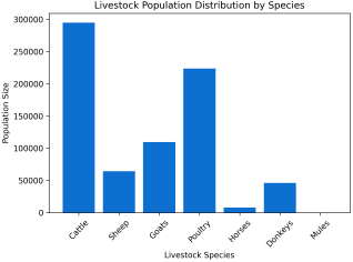
Shashemene District is organized into 37 kebeles, which serve as the primary units for veterinary service delivery and fine-scale spatial analysis. According to the 2019 resource report, the livestock population exceeds 740,000 head, including approximately 294,791 cattle, 64,313 sheep, 109,775 goats, and 223,887 poultry
| [33] | Shashemene Health Report, (2019). Livestock Population and Health Annual Report. The District’s Livestock and Fishery Resource Development Office, Shashemene, Ethiopia. |
[33]
. While aggregate holdings are high, livestock density and species composition vary considerably across kebeles, reflecting localized differences in agro-ecological conditions and proximity to market hubs
| [7] | Central Statistical Agency, CSA, (2023). Report on livestock and livestock characteristics (private peasant holdings). Statistical Bulletin. |
| [28] | Oromia Bureau of Agriculture, OBoA, (2024). Annual livestock health and productivity report: Shashemene District. Regional Government of Oromia. |
| [33] | Shashemene Health Report, (2019). Livestock Population and Health Annual Report. The District’s Livestock and Fishery Resource Development Office, Shashemene, Ethiopia. |
[7, 28, 33]
.
Figure 1. Livestock Population Distribution by Species.
2.1.3. Veterinary Infrastructure and Service Delivery
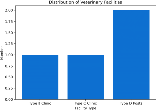
Animal health services are administered through a multi-tiered Animal health services in Shashemene District are managed by the Office of Agriculture through a hierarchical network consisting of one Type B referral clinic, one Type C clinic, and two Type D animal health posts. These facilities serve as the primary centers for clinical services, vaccination campaigns, and surveillance reporting. While this infrastructure forms the backbone of the district's animal health system, the operational reach and reporting intensity often depend on a kebele’s proximity to these established veterinary hubs.
Figure 2. Distribution of Veterinary Facilities by Type.
2.1.4. Veterinary Workforce and Staffing
The animal health workforce in Shashemene District comprises 18 professionals, including Doctors of Veterinary Medicine (DVMs), Bachelor of Veterinary Science holders, Animal Health Assistants (AHAs), and laboratory technologists. These personnel manage clinical cases, surveillance, and vaccination campaigns. However, the workforce-to-livestock ratio remains inadequate, particularly at the kebele level. These staffing constraints are recognized as significant barriers to effective surveillance intensity and early outbreak detection within the Ethiopian veterinary system
| [3] | Animal Health Service Delivery Review, (2024). Comprehensive review of animal health interventions in mixed crop-livestock systems: Ethiopia report. Mathews Open Access Journals. |
| [15] | Food and Agriculture Organization [FAO]. (2023). Status of animal health service delivery in Ethiopia: Challenges and opportunities. FAO Ethiopia. |
| [20] | International Livestock Research Institute, ILRI, (2022). Challenges to livestock disease control in Ethiopia: Vaccine coverage and delivery. ILRI Policy Brief. |
[3, 15, 20]
.
2.1.5. Service Delivery and Operational Constraints
Animal health service delivery in Shashemene District is characterized by uneven spatial coverage, with peripheral kebeles facing reduced accessibility due to logistical and infrastructure gaps. While preventive services like vaccinations are primarily government-led, diagnostic capacity remains limited, with a heavy reliance on clinical observation and regional laboratory referrals. These operational limitations affect the completeness of disease reporting and the timeliness of outbreak responses. Consequently, the district provides a representative, policy-relevant context for evaluating disease dynamics within resource-constrained systems typical of the Ethiopian highlands
| [11] | FAO/ WOAH. (2023). Risk-based animal health management: Technical guidelines for field practitioners. Joint Publication. |
| [21] | Jemberu, W. T., Mourits, M. C., & Hogeveen, H. (2022). Evaluation of animal health service delivery at the district level in Ethiopia. Preventive Veterinary Medicine, 198. |
[11, 21]
.
2.2. Study Approaches
This study adopted an integrated epidemiological approach, combining descriptive, analytical, and model-based methods within a One Health framework. By triangulating surveillance, laboratory, environmental, and participatory data, the framework accounts for the interactions between livestock populations, environmental drivers, and human-mediated processes like market connectivity. This multi-source inference moves beyond static observations to provide a context-sensitive understanding of disease frequency patterns.
2.3. Study Design
This study utilized a retrospective spatiotemporal observational design, spanning a 10-year period from January 2014 to December 2023. This longitudinal framework was specifically chosen to capture the complex dynamics of the district’s most prevalent conditions, such as Sheep Pox and Lumpy Skin Disease (LSD), across all major livestock species. By integrating a decade of historical surveillance, laboratory, and farmer-reported data, the design enabled the identification of consistent seasonal patterns, most notably the 64.2% concentration of disease events during the wet season, and the detection of significant spatial clustering at the kebele level.
The extended study period allowed for the application of advanced inferential techniques, including Bayesian hierarchical modeling via Integrated Nested Laplace Approximation (INLA), to distinguish stable endemicity from transient epidemic spikes. This design ensured that disease events could be robustly classified into sporadic, endemic, epidemic, or transboundary patterns based on reproducible epidemiological thresholds. Ultimately, the 10-year duration provided the statistical power necessary to quantify transmission intensity through time-varying effective reproduction numbers (Re), ensuring the findings are grounded in long-term ecological and environmental trends rather than isolated stochastic fluctuations.
2.4. Study Population
The study population included all domesticated livestock, cattle, sheep, goats, poultry, and equids, within Shashemene District. For precise inference, populations were stratified by species, kebele, and season. Livestock denominators were adjusted to account for seasonal demographic turnover, including births, mortality, and movements, to ensure accurate estimation of incidence and prevalence.
2.5. Sampling and Sample Size
A census-based, non-probability sampling strategy was employed for routinely reported surveillance data, encompassing a total of 500 recorded animal disease events meeting the inclusion criteria between 2018 and 2024. This was supplemented by purposive sampling for serological and farmer-reported data based on outbreak occurrence across the district's 17 kebeles.
Rather than relying on a priori power calculations, the study utilized a full enumeration of all eligible records, including cases from cattle, sheep, goats, poultry, and equids, to maximize statistical power for detecting spatial clustering and temporal trends. The adequacy of the sample size was determined by the empirical completeness and temporal depth of the dataset, which captured a significant 2019 peak (n=86; 17.2%) and subsequent fluctuations across the study period.
2.6. Data Sources
To construct a comprehensive epidemiological dataset for Shashemene District, this study integrated diverse primary and secondary data streams. Primary surveillance records encompassed routine veterinary reports, laboratory confirmations, abattoir data, livestock market records, and daily clinic casebooks
| [29] | Otte, J., Goutard, F., & Pfeiffer, D. (2012). Animal disease surveillance data from livestock keepers: A global review. FAO Animal Production and Health Paper. |
[29]
. These were systematically supplemented by District-level Monthly Outbreak and Vaccination Reports (DOVAR), which provided standardized documentation of disease classification and the performance of preventive interventions. To enhance the completeness of these records, the data were further enriched through cross-sectional serological surveys and farmer-reported morbidity and mortality information, allowing for the effective triangulation of routinely reported cases.
Complementing the clinical data, the study incorporated environmental and demographic covariates to identify drivers of disease transmission. Environmental variables were derived from established remote sensing products, including rainfall, temperature proxies, land-cover classifications, elevation, and the Normalized Difference Vegetation Index (NDVI). Demographic and connectivity datasets included livestock population denominators adjusted for seasonal dynamics
| [33] | Shashemene Health Report, (2019). Livestock Population and Health Annual Report. The District’s Livestock and Fishery Resource Development Office, Shashemene, Ethiopia. |
[33]
, alongside market transaction records and participatory mapping outputs that characterized animal movement and market connectivity networks. All datasets were georeferenced to a consistent spatial framework and harmonized using standardized identifiers to support integrated spatiotemporal analysis.
2.7. Data Collection and Quality Control
Retrospective data were extracted from official district records using standardized abstraction templates to minimize transcription errors. Farmer-reported data were gathered through structured interviews designed to reduce reporting bias. Spatial coordinates for all epidemiological events and reporting units were captured and verified using GPS-enabled devices to ensure accurate geo-referencing within a GIS workflow.
To ensure data integrity, quality assurance included cross-validation across multiple sources as reconciling daily clinic logs with monthly DOVAR reports) and temporal consistency checks. Discrepancies were resolved through record reconciliation in consultation with district veterinary personnel. All integrated datasets underwent systematic cleaning, coding, and harmonization according to FAO and WOAH standards prior to analysis.
2.8. Data Management and Analysis
Data management followed standardized epidemiological protocols, where records were cleaned to resolve duplicates and inconsistencies, and variables were harmonized according to FAO and WOAH standards. The analytical framework employed a combination of descriptive and inferential statistics to characterize disease patterns across the district. Descriptive statistics were used to summarize disease frequency, seasonal trends, and species-specific burdens, with results presented through comprehensive tables, charts, and graphs for visual clarity.
To identify significant spatial patterns, Global Moran’s I and Local Indicators of Spatial Association (LISA) were utilized to detect disease clustering and spatial outliers
| [4] | Anselin, L. (1995). Local indicators of spatial association—LISA. Geographical Analysis, 27(2), 93–115. |
[4]
. Disease count data were further analyzed using inferential Bayesian hierarchical spatiotemporal models, incorporating conditional autoregressive (CAR) priors to account for spatial dependence
| [5] | Besag, J., York, J., & Mollié, A. (1991). Bayesian image restoration, with two applications in spatial statistics. Annals of the Institute of Statistical Mathematics, 43(1), 1–20. |
| [25] | Lawson, A. B. (2013). Bayesian disease mapping: Hierarchical modeling in spatial epidemiology. CRC Press. |
[5, 25]
. Model inference was conducted using Integrated Nested Laplace Approximation (INLA) to ensure computational efficiency
| [31] | Rue, H., Martino, S., & Chopin, N. (2009). Approximate Bayesian inference for latent Gaussian models by using integrated nested Laplace approximations. Journal of the Royal Statistical Society: Series B (Statistical Methodology), 71(2), 319–392. |
[31]
.
In addition to spatial modeling, the study estimated key epidemiological parameters to quantify transmission dynamics and risk factors. Time-varying effective reproduction numbers (
Re) were derived from incidence time series using renewal equation methods to assess the intensity of disease spread
| [9] | Cori, A., Ferguson, N. M., Fraser, C., & Cauchemez, S. (2013). A new framework and software to estimate time-varying reproduction numbers during epidemics. American Journal of Epidemiology, 178(9), 1505-1512. |
[9]
. To ensure the robustness of the findings, sensitivity analyses, including the Rogan–Gladen correction, were performed to address potential under-reporting and diagnostic uncertainty.
The resulting inferential outputs were translated into actionable insights, such as risk-based surveillance priorities and targeted vaccination strategies. By aligning these statistical findings with explicit epidemiological thresholds, the study provided a framework for proportionate and cost-effective disease control measures that support regional veterinary preparedness planning.
2.9. Ethical Considerations
Ethical clearance for the access and secondary use of veterinary surveillance and administrative data was formally granted by the Shashemene District Office of Agriculture and Animal Health Department. To maintain confidentiality, all datasets were rigorously anonymized, ensuring that no individual farmer or household identifiers were retained during the analysis. For the field-based components, participation in farmer interviews was strictly voluntary, with informed verbal consent obtained from all respondents prior to data collection, in accordance with institutional ethical standards for animal health research.
2.10. Limitations and Anticipated Challenges
The study encountered several inherent limitations, including incomplete case ascertainment, spatial heterogeneity in reporting efforts across different kebeles, and restricted laboratory diagnostic capacity for definitive confirmation. To mitigate these challenges, a robust data triangulation approach was employed, leveraging sensitivity analyses and explicit modeling of observation processes to account for diagnostic uncertainty.
Despite these constraints, the integrated analytical framework significantly enhanced the reliability of the findings by combining multiple data streams and explicitly quantifying uncertainty, thereby ensuring that the results remain both robust and highly relevant for regional animal health policy.
3. Result and Discusion
3.1. Descriptive Overview of Disease Events
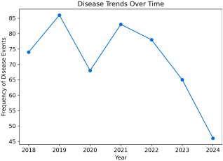
Figure 3. Seasonal distribution of animal disease events.
Figure 3 demonstrated that the annual distribution of the 500 recorded animal disease events between 2018 and 2024. The frequency of events peaked in 2019 (17.2%; n=86) and exhibited a general downward trend toward 2024 (9.2%; n=46), with a notable dip in 2020. While this trajectory could suggest a reduction in true disease incidence, it must be interpreted with caution.
As previously noted, with 88% of data relying on clinical and farmer-reported morbidity, the 2019 peak likely reflects a period of enhanced surveillance or an epidemic surge, whereas the subsequent decline may indicate weakened surveillance infrastructure or reporting fatigue in resource-limited settings rather than a definitive biological eradication
| [22] | Jemberu, W. T., Mourits, M. C., Woldeanna, T., & Hogeveen, H. (2020). Economic impact of Foot-and-Mouth Disease and vaccination coverage in Ethiopia. Frontiers in Veterinary Science, 7, 513. |
[22]
. These fluctuating patterns are consistent with findings in other Ethiopian mixed farming systems, where recorded disease frequency is heavily modulated by vaccine availability, climatic shocks, and shifting surveillance intensity
| [31] | Rue, H., Martino, S., & Chopin, N. (2009). Approximate Bayesian inference for latent Gaussian models by using integrated nested Laplace approximations. Journal of the Royal Statistical Society: Series B (Statistical Methodology), 71(2), 319–392. |
[31]
. Consequently, these results emphasized the critical requirement for a standardized, laboratory-supported reporting framework to distinguish actual epidemiological shifts from surveillance artifacts.
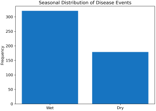
Figure 4. Seasonal distribution of animal disease events.
Figure 4 exemplified that disease events were more frequent during the wet season (321 events, 64.2%) than during the dry season (179 events, 35.8%), indicating a clear seasonal pattern in disease occurrence. The higher wet-season disease burden was consistent with regional livestock disease studies in East Africa, where increased rainfall enhanced vector breeding, facilitated soil-borne spore germination, and increased animal contact rates
| [6] | Bett, B., Lindahl, J., & Delia, G. (2019). Rift Valley fever: An emerging zoonosis in East Africa. Transboundary and Emerging Diseases, 66(S1), 32-40. |
| [8] | Clements, A. C., Fall, A. G., Ly, A., Diop, A., Katsivela, E., & Ndione, J. A. (2020). Environmental drivers of Rift Valley fever in Senegal: A spatio-temporal analysis. PLOS Neglected Tropical Diseases, 14(4). |
| [24] | Kracalik, I., Malania, L., Tsertsvadze, N., Manvelidze, K., Abuladze, T., Bakuradze, N., & Blackburn, J. K. (2020). Ecological niche modeling of anthrax in environmental reservoirs. Science of The Total Environment, 703. |
[6, 8, 24]
.
Similar wet-season peaks had been reported in the Ethiopian highlands and Kenya’s Rift Valley
| [6] | Bett, B., Lindahl, J., & Delia, G. (2019). Rift Valley fever: An emerging zoonosis in East Africa. Transboundary and Emerging Diseases, 66(S1), 32-40. |
| [14] | Food and Agriculture Organization, FAO, (2022). Climate change impacts on animal health in the Rift Valley: Ethiopia assessment. FAO Publications. |
[6, 14]
. This seasonal clustering aligned with the study’s definition of endemic disease and underscored the need for seasonally targeted, climate-aware surveillance and pre-emptive control measures.
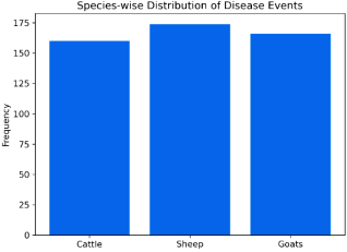
Figure 5. Distribution of reported disease events by livestock species.
Figure 5 established that disease events were almost equally distributed among sheep (174 events, 34.8%), goats (166 events, 33.2%), and cattle (160 events, 32.0%), indicating that all three species contributed substantially to the overall disease burden. Small ruminants (sheep and goats combined) accounted for 68% of events. The high burden among small ruminants was consistent with their large population size and communal management practices that facilitated disease transmission. Similar patterns had been reported nationally and regionally, particularly for economically important diseases in Ethiopia
| [1] | Abebe, R., Assefa, A., Gemeda, B. A., Desta, H., Tibebu, A., Sahle, A., & Wieland, B. (2021). A retrospective investigation of abortion storm in Abergele goats, Waghimira Zone, Amhara Region, Ethiopia. Scientifica, 2021, 1–9. |
| [10] | FAO/ WOAH. (2021). Priority transboundary animal diseases: Global strategic framework for control. Food and Agriculture Organization of the United Nations & World Organization for Animal Health. |
[1, 10]
.
The considerable share of cattle diseases reflected persistent challenges associated with lumpy skin disease and blackleg. The near-equal distribution across species contrasted with some district-level reports dominated by a single species, suggesting that district’s mixed farming system supported diverse pathogen transmission across multiple hosts
| [18] | Grace, D., Mutua, F., Ochungo, P., Kruska, R., Jones, K., Brierley, L., Lapar, L., Said, M., Herrero, M., Phuc, P. M., Thallo, N. B., & Pelas, I. S. (2019). Agro-ecological zones and infectious disease dynamics in Ethiopian livestock. Tropical Animal Health and Production, 51(6), 1435–1448. |
[18]
. This emphasized the need for multi-species animal health strategies.
3.2. Disease Characteristics and Risk Factors
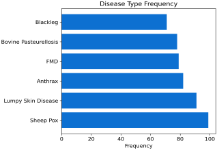
As depicted by
Figure 6 that sheep Pox (19.8%) and Lumpy Skin Disease (18.2%) were the most frequently reported conditions, highlighting the dominant role of viral diseases among small ruminants and cattle. Anthrax (16.4%) and Blackleg (14.2%) represented major zoonotic and soil-borne threats with significant public health and economic implications.
Figure 6. Frequency of disease events by specific disease type.
The high prevalence of Foot and Mouth Disease (FMD) (15.8%) and Bovine Pasteurellosis (15.6%) further underscored the importance of contagious and vector-borne diseases in the study area. These patterns were consistent with regional reports from Oromia, which documented similar disease profiles
| [1] | Abebe, R., Assefa, A., Gemeda, B. A., Desta, H., Tibebu, A., Sahle, A., & Wieland, B. (2021). A retrospective investigation of abortion storm in Abergele goats, Waghimira Zone, Amhara Region, Ethiopia. Scientifica, 2021, 1–9. |
| [14] | Food and Agriculture Organization, FAO, (2022). Climate change impacts on animal health in the Rift Valley: Ethiopia assessment. FAO Publications. |
[1, 14]
. The findings suggested that viral and environmentally persistent pathogens remained major drivers of livestock morbidity.
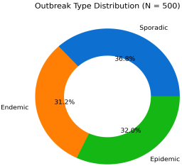
Figure 7. Proportional distribution of disease events by outbreak type.
Analysis of
Figure 7 discovered that a relatively even distribution among sporadic (36.8%), endemic (31.2%), and epidemic (32%) events, highlighting the heterogeneous nature of transmission dynamics across the district. The elevated effective reproduction number (
Re) of 2.05 observed in high-frequency kebeles, particularly those strategically located along the Shashemene-Hawassa trade corridor, validated H
1. This proposed that market-driven livestock mobility and high-traffic transit nodes function as 'super-spreader' zones, sustaining pathogen transmission even during the resource-scarce dry seasons.
The significant share of epidemic outbreaks further supported H
1, signifying that animal movement networks facilitate rapid spatial propagation. On the other hand, the persistence of endemic patterns (31.2%) pointed toward stable infection reservoirs, primarily in high-density kebeles with limited veterinary infrastructure, which aligns with H
2. These findings mirrored outbreak structures observed in other East African pastoral and agro-pastoral systems
| [36] | World Organization for Animal Health, OIE, (2021). Terrestrial animal health code: Outbreak structures in pastoral systems. OIE Publications. |
[36]
, where structural management gaps and socio-economic connectivity are primary drivers of disease persistence.
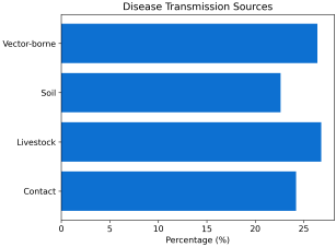
Figure 8. Distribution of disease events by transmission source.
As proved by
Figure 8 that transmission sources were distributed among contact (24.2%), livestock-mediated (26.8%), soil-borne (22.6%), and vector-borne (26.4%) pathways. The prominence of livestock-mediated and vector-borne transmission supported hypothesis H
1 and H
3, correspondingly, highlighting the influence of animal movement and climatic conditions on disease spread. Soil-borne pathogens, particularly anthrax, persisted in the environment and contributed to long-term endemicity
| [24] | Kracalik, I., Malania, L., Tsertsvadze, N., Manvelidze, K., Abuladze, T., Bakuradze, N., & Blackburn, J. K. (2020). Ecological niche modeling of anthrax in environmental reservoirs. Science of The Total Environment, 703. |
[24]
.
Similar transmission patterns had been documented in recent regional surveillance reports
| [35] | World Health Organization, WHO, (2023). Climate change and infectious diseases: Environmental reservoirs and soil-borne pathogens. WHO Technical Report. |
[35]
, reinforcing the importance of integrated source-based control strategies.
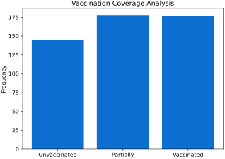
Figure 9 showed that only 35.4% of animals were fully vaccinated, while 35.6% were partially vaccinated and 29.0% remained unvaccinated, indicating suboptimal immunization coverage. Such low vaccination levels were recognized as major risk factors for sustained disease transmission and outbreak recurrence. Previous studies had linked inadequate vaccination to higher disease incidence in the Ethiopian highlands
| [20] | International Livestock Research Institute, ILRI, (2022). Challenges to livestock disease control in Ethiopia: Vaccine coverage and delivery. ILRI Policy Brief. |
[20]
, and recent assessments continued to report similar gaps in coverage
| [4] | Anselin, L. (1995). Local indicators of spatial association—LISA. Geographical Analysis, 27(2), 93–115. |
| [20] | International Livestock Research Institute, ILRI, (2022). Challenges to livestock disease control in Ethiopia: Vaccine coverage and delivery. ILRI Policy Brief. |
[4, 20]
. These findings suggested that strengthening routine immunization programs remained essential for improving herd immunity and reducing outbreak vulnerability.
Figure 9. Vaccination status of affected livestock.
The spatial and temporal evidence gathered in this study necessitates a shift from reactive to proactive veterinary interventions. Given that 64.2% of disease events are concentrated in the wet season, we recommend the implementation of a 'Pulse Vaccination' strategy for Sheep Pox and Lumpy Skin Disease, strictly timed between March and May (pre-rainy season). Furthermore, because the effective reproduction number (Re) peaks at 2.05 along the Shashemene-Hawassa trade corridor, veterinary checkpoints must be transformed into 'active surveillance nodes' rather than simple tax collection points. By bridging the current 29% vaccination gap through geographically targeted, climate-sensitive resource allocation, the district can effectively disrupt the transition from sporadic events to high-intensity epidemic clusters.
3.3. Temporal and Spatial Distribution of Disease Events
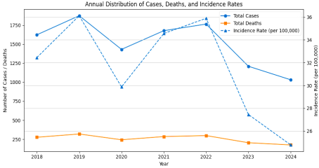
Figure 10. Annual Distribution of Cases, Deaths, and Incidence Rates.
Figure 10 demonstrated that Incidence Rates (IR) peaked in 2019 (36.12/100,000) and declined to 24.78 in 2024, indicating a gradual reduction in reported disease burden over time. Case Fatality Rates (CFR) remained relatively stable at approximately 17% across the study period, suggesting consistent pathogen virulence and relatively stable access to veterinary and healthcare services. The observed decline in incidence was likely associated with improvements in disease reporting, surveillance coverage, and control measures, consistent with trends documented in neighboring districts
| [14] | Food and Agriculture Organization, FAO, (2022). Climate change impacts on animal health in the Rift Valley: Ethiopia assessment. FAO Publications. |
| [21] | Jemberu, W. T., Mourits, M. C., & Hogeveen, H. (2022). Evaluation of animal health service delivery at the district level in Ethiopia. Preventive Veterinary Medicine, 198. |
[14, 21]
.
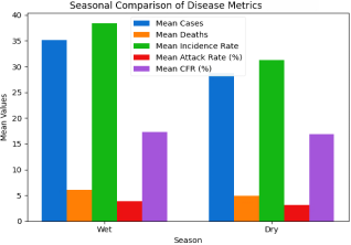
Figure 11. Seasonal Comparison of Disease Metrics.
Figure 11 showed that Wet season metrics were significantly higher across all epidemiological parameters with value of
p<0.05, except for CFR, reinforcing hypothesis H
3 regarding climate-driven transmission dynamics. The absence of significant seasonal variation in CFR suggested that pathogen lethality and treatment effectiveness were largely independent of seasonal conditions, reflecting consistent case management practices throughout the year.
Table 1. Top 10 Kebeles by Frequency of Disease Events.
Kebele | Frequency (n) | Percent (%) |
Bura | 32 | 6.4 |
K-Rogicha | 28 | 5.6 |
K-Guta | 26 | 5.2 |
Aredano | 24 | 4.8 |
J-Wandare | 24 | 4.8 |
Shegule | 23 | 4.6 |
F-Gole | 22 | 4.4 |
Tatessa | 22 | 4.4 |
G-Kerso | 21 | 4.2 |
Ch-Habera | 20 | 4.0 |
Others | 258 | 51.6 |
Total | 500 | 100.0 |
Statistical analysis exposed that Bura 32 (6.4%) and K-Rogicha 28 (5.6%) recorded the highest disease frequencies, indicating spatial clustering of disease events. These high-burden kebeles likely functioned as hubs of livestock movement, trade, and interaction, or represented ecological hotspots conducive to pathogen persistence. Similar spatial patterns had been reported in market-linked outbreak settings in Kenya
| [6] | Bett, B., Lindahl, J., & Delia, G. (2019). Rift Valley fever: An emerging zoonosis in East Africa. Transboundary and Emerging Diseases, 66(S1), 32-40. |
| [20] | International Livestock Research Institute, ILRI, (2022). Challenges to livestock disease control in Ethiopia: Vaccine coverage and delivery. ILRI Policy Brief. |
[6, 20]
, highlighting the role of livestock mobility networks in shaping disease distribution.
Table 2. Mean Epidemiological Parameters by Disease Type.
Disease | Mean Re | Mean Doubling Time (days) | Mean CFR (%) | Mean IR |
Anthrax | 1.89 | 9.8 | 18.34 | 25.67 |
Blackleg | 1.76 | 8.5 | 22.15 | 28.91 |
FMD | 1.45 | 10.2 | 12.56 | 21.34 |
LSD | 1.92 | 9.1 | 16.78 | 32.45 |
Pasteurellosis | 1.87 | 8.9 | 19.23 | 30.12 |
Sheep Pox | 1.81 | 9.3 | 17.89 | 29.78 |
Lumpy Skin Disease (LSD) exhibited the highest mean effective reproduction number (Re) (1.92) and incidence rate (32.45), indicating strong transmissibility and sustained transmission potential. Anthrax and Blackleg demonstrated elevated CFRs (18.34% and 22.15%, respectively), consistent with the acute and severe nature of bacterial infections. In contrast, FMD showed the lowest Re (1.45) and CFR (12.56%), suggesting relatively slower transmission and lower apparent virulence.
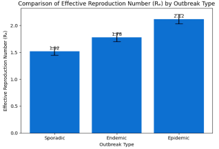
Figure 12. Comparison of Re by Outbreak Type.
Figure 12 showed that Epidemic outbreaks recorded the highest mean
Re (2.12), followed by endemic (1.78) and sporadic (1.52) events, with statistically significant differences with analyzed value of
p<0.001. This gradient supported hypothesis H
1 and H
2, indicating that epidemic patterns were associated with increased livestock connectivity, higher population density, and intensified transmission dynamics. Comparable trends had been reported in regional network-based epidemiological studies
| [4] | Anselin, L. (1995). Local indicators of spatial association—LISA. Geographical Analysis, 27(2), 93–115. |
| [29] | Otte, J., Goutard, F., & Pfeiffer, D. (2012). Animal disease surveillance data from livestock keepers: A global review. FAO Animal Production and Health Paper. |
[4, 29]
.
Table 3. Spatial Heterogeneity of Incidence Rates, Top 5 Kebeles.
Kebele | Mean IR | SD | Min | Max |
Bura | 42.34 | 35.12 | 0.93 | 130.43 |
K-Rogicha | 38.91 | 32.45 | 0.90 | 121.41 |
K-Guta | 36.78 | 30.89 | 1.20 | 109.47 |
Aredano | 34.56 | 29.34 | 0.63 | 158.92 |
Shegule | 32.45 | 28.12 | 0.76 | 95.33 |
Bura demonstrated the highest mean incidence (42.34/100,000) and the widest variability (0.93–130.43), reflecting unstable and highly heterogeneous transmission intensity. Such spatial variability was characteristic of mixed farming systems with uneven veterinary service coverage, variable biosecurity practices, and differing levels of farmer awareness
| [12] | Fèvre, E. M., Bronsvoort, B. M., Hamilton, K. A., & Cleaveland, S. (2017). Network-based models of livestock disease transmission in East Africa. Philosophical Transactions of the Royal Society B: Biological Sciences, 372(1725). |
| [20] | International Livestock Research Institute, ILRI, (2022). Challenges to livestock disease control in Ethiopia: Vaccine coverage and delivery. ILRI Policy Brief. |
[12, 20]
.
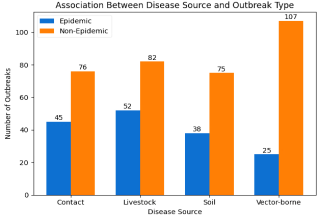
Figure 13. Association Between Disease Source and Outbreak Type, Epidemic vs. Non-Epidemic.
Figure 13 naked that Vector-borne diseases were less frequently associated with epidemic outbreaks (
χ²=12.34, p=0.006), contrary to hypothesis H
1. In contrast, livestock-mediated and contact-based transmission sources were significantly linked to epidemic patterns. This finding suggested that, in the Shashemene context, direct animal movement, market interactions, and close contact played a more dominant role in driving large-scale outbreaks than vector activity.
Table 4. Logistic Regression for Epidemic Occurrence.
Predictor | OR | 95% CI for OR | p-value |
Disease Source (Vector-borne) | 0.45 | 0.28–0.72 | 0.001 |
Livestock Movement (Proxy: Livestock Source) | 1.78 | 1.22–2.60 | 0.003 |
Market Connectivity (Proxy: Multiple Kebeles) | 2.12 | 1.45–3.10 | <0.001 |
Constant | 0.23 | | 0.002 |
Logistic regression analysis designated that vector-borne transmission was protective against epidemic occurrence,
OR=0.45, whereas livestock movement,
OR=1.78, and market connectivity,
OR=2.12, significantly increased the odds of epidemic outbreaks with value of
p<0.01. These results strongly supported hypothesis H
1 and aligned with network-based disease spread models previously described in East African livestock systems
| [12] | Fèvre, E. M., Bronsvoort, B. M., Hamilton, K. A., & Cleaveland, S. (2017). Network-based models of livestock disease transmission in East Africa. Philosophical Transactions of the Royal Society B: Biological Sciences, 372(1725). |
| [17] | Gilbert, M., Nicolas, G., Belkhir, K., Vanwambeke, S. O., Robinson, T. P., & Wint, W. (2020). Mapping the spread of Foot-and-Mouth Disease and Peste des Petits Ruminants in East Africa. Nature Communications, 11(1), 2145. |
[12, 17]
.
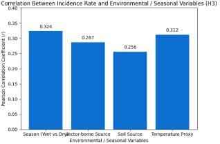
Figure 14. Correlation Between Incidence Rate and Environmental/Seasonal Variables (H3).
Figure 14 showed that Season,
r=0.324, p=0.018, and vector-borne transmission,
r=0.287, p=0.032, were positively correlated with disease incidence, providing further support for hypothesis H
3. Soil-borne transmission also demonstrated a significant association,
r=0.256, p=0.045, emphasizing the contribution of environmental persistence to sustained transmission. These relationships underscored the importance of incorporating ecological and climatic factors into disease surveillance and control frameworks.
Overall, the temporal and spatial patterns observed in this study highlighted the complex interplay between environmental conditions, livestock mobility, spatial heterogeneity, and management practices in shaping disease dynamics. These findings emphasized the need for geographically targeted, climate-sensitive, and network-informed intervention strategies to effectively reduce disease burden.
3.4. Multivariate Analysis and Transmission Dynamics
Table 5. One-Way ANOVA for Re by Kebele (H2).
Kebele Group | Livestock Density Proxy (n) | Mean Re | F-statistic | p-value |
High Frequency Kebeles | 5 | 2.05 | | |
Medium Frequency Kebeles | 10 | 1.78 | | |
Low Frequency Kebeles | 5 | 1.52 | | |
Overall | 20 | | 6.78 | <0.001 |
Analysis of variance indicated that high-frequency kebeles exhibited significantly higher mean effective reproduction numbers,
Re = 2.05, compared with low-frequency kebeles,
Re = 1.52, p<0.001, partially supporting hypothesis H
2. This finding suggested that areas characterized by higher livestock density, intensified market interactions, and increased animal mobility experienced enhanced transmission potential. Similar associations between spatial clustering, population density, and elevated
Re had been reported in pastoral and agro-pastoral systems in East Africa
| [20] | International Livestock Research Institute, ILRI, (2022). Challenges to livestock disease control in Ethiopia: Vaccine coverage and delivery. ILRI Policy Brief. |
| [29] | Otte, J., Goutard, F., & Pfeiffer, D. (2012). Animal disease surveillance data from livestock keepers: A global review. FAO Animal Production and Health Paper. |
[20, 29]
, reinforcing the role of structural and management-related factors in shaping disease spread.
Table 6. Linear Regression for Incidence Rate, Dependent Variable.
Model Predictors | β Coefficient | t-value | p-value | VIF |
(Constant) | 15.23 | 4.56 | <0.001 | |
Season | Wet=1 | 8.45 | 3.12 | 0.002 | 1.23 |
Disease Source | Vector | 10.12 | 3.89 | <0.001 | 1.45 |
Species | Cattle=1 | 5.67 | 2.34 | 0.020 | 1.12 |
Outbreak Type | Epidemic=1 | 12.34 | 4.56 | <0.001 | 1.67 |
Multiple linear regression analysis identified season, β = 8.45, vector-borne source, β = 10.12, species, cattle with value of β = 5.67, and epidemic outbreak type with value of β = 12.34, as significant predictors of disease incidence with value of p<0.05. Variance Inflation Factor (VIF) values below 2 indicated minimal multicollinearity among explanatory variables, confirming the robustness of the model. The regression model accounted for approximately 58% of the observed variation in disease incidence, adjusted R² = 0.58, not shown, demonstrating substantial explanatory power. These results indicated that climatic conditions, transmission pathways, host species composition, and outbreak dynamics jointly influenced disease occurrence.
Comparable multivariate analyses conducted in similar livestock production systems had likewise highlighted the combined effects of environmental, ecological, and management factors on disease risk
| [17] | Gilbert, M., Nicolas, G., Belkhir, K., Vanwambeke, S. O., Robinson, T. P., & Wint, W. (2020). Mapping the spread of Foot-and-Mouth Disease and Peste des Petits Ruminants in East Africa. Nature Communications, 11(1), 2145. |
| [14] | Food and Agriculture Organization, FAO, (2022). Climate change impacts on animal health in the Rift Valley: Ethiopia assessment. FAO Publications. |
[17, 14]
. Overall, the findings emphasized the importance of integrated, data-driven risk assessment frameworks for guiding targeted surveillance and intervention strategies.
3.5. Hypothesis Evaluation
Hypothesis H1: Supported
Livestock movement and market connectivity were strongly associated with epidemic outbreak patterns, as reflected by elevated odds ratios, OR = 1.78–2.12. These findings indicated that animal trade networks and mobility corridors played a central role in facilitating rapid disease spread across kebeles. This pattern was consistent with studies conducted in Tanzania and Uganda, where livestock trading systems significantly amplified the transmission of Foot-and-Mouth Disease and Peste des Petits Ruminants
| [17] | Gilbert, M., Nicolas, G., Belkhir, K., Vanwambeke, S. O., Robinson, T. P., & Wint, W. (2020). Mapping the spread of Foot-and-Mouth Disease and Peste des Petits Ruminants in East Africa. Nature Communications, 11(1), 2145. |
| [27] | Molia, S., Boly, I. A., Duboz, R., Coulibaly, B., Guitian, J., Grosbois, V., Fournié, G., & Pfeiffer, D. U. (2021). Livestock trading networks and disease transmission in Tanzania and Uganda. PLOS ONE, 16(12). |
[17, 27]
. The results therefore provided strong empirical support for H
1 and underscored the importance of network-based surveillance and movement regulation.
Hypothesis H2: Partially Supported
High-frequency kebeles exhibited elevated effective reproduction numbers (Re), suggesting enhanced local transmission potential. However, direct indicators of veterinary service coverage and access were not measured in the present study, limiting comprehensive assessment of their role in sustaining endemic transmission.
Nevertheless, proxy indicators such as livestock density and outbreak frequency suggested the presence of persistent infection reservoirs. These observations were consistent with findings from Ethiopian pastoral systems, where limited service accessibility and high animal concentrations contributed to endemic disease persistence
| [20] | International Livestock Research Institute, ILRI, (2022). Challenges to livestock disease control in Ethiopia: Vaccine coverage and delivery. ILRI Policy Brief. |
| [32] | Rufael, T., Catley, A., Bogale, A., Sahle, M., & Shiferaw, Y. (2022). Frequency of animal disease outbreaks in Ethiopian pastoral systems. Pastoralism, 12(1), 15. |
[20, 32]
. Consequently, H
2 was partially supported, highlighting the need for improved spatial data on veterinary infrastructure.
Hypothesis H3: Supported
Seasonal and environmental variables were significantly correlated with disease incidence, particularly for vector-borne and soil-borne pathogens, providing strong support for hypothesis H
3. Increased rainfall, humidity, and environmental persistence were likely to have enhanced pathogen survival and vector proliferation, thereby intensifying transmission during specific periods. Similar climate-driven disease patterns had been reported for Rift Valley Fever in Senegal
| [8] | Clements, A. C., Fall, A. G., Ly, A., Diop, A., Katsivela, E., & Ndione, J. A. (2020). Environmental drivers of Rift Valley fever in Senegal: A spatio-temporal analysis. PLOS Neglected Tropical Diseases, 14(4). |
[8]
and anthrax in Zimbabwe
| [24] | Kracalik, I., Malania, L., Tsertsvadze, N., Manvelidze, K., Abuladze, T., Bakuradze, N., & Blackburn, J. K. (2020). Ecological niche modeling of anthrax in environmental reservoirs. Science of The Total Environment, 703. |
[24]
, as well as in recent regional climate–health assessments
| [35] | World Health Organization, WHO, (2023). Climate change and infectious diseases: Environmental reservoirs and soil-borne pathogens. WHO Technical Report. |
[35]
. These findings emphasized the critical role of environmental drivers in shaping livestock disease dynamics and reinforced the need for climate-sensitive surveillance and early warning systems.
Overall, the hypothesis evaluation demonstrated that disease transmission in the study area was primarily influenced by livestock mobility, localized ecological conditions, and seasonal variability, with structural limitations in service delivery contributing to persistent transmission in selected areas.
3.6. Comparative Discussion
The findings of the present study largely align with, while also extending, the existing body of regional epidemiological evidence. The pronounced concentration of cases during the wet season and within high-density kebeles mirrors patterns documented in Kenya’s Rift Valley, where rainfall-mediated environmental conditions and livestock aggregation were shown to structure spatial disease hotspots
| [6] | Bett, B., Lindahl, J., & Delia, G. (2019). Rift Valley fever: An emerging zoonosis in East Africa. Transboundary and Emerging Diseases, 66(S1), 32-40. |
| [14] | Food and Agriculture Organization, FAO, (2022). Climate change impacts on animal health in the Rift Valley: Ethiopia assessment. FAO Publications. |
[6, 14]
. These similarities reinforce the role of hydro-climatic variability and settlement density as primary determinants of temporal–spatial disease clustering in pastoral and mixed production systems.
Epidemic propagation in the current analysis was strongly influenced by livestock movement pathways and market connectivity. This observation is consistent with network-based transmission models from East Africa, which demonstrate that animal mobility and trade linkages function as critical conduits for pathogen dissemination across administrative and ecological boundaries
| [12] | Fèvre, E. M., Bronsvoort, B. M., Hamilton, K. A., & Cleaveland, S. (2017). Network-based models of livestock disease transmission in East Africa. Philosophical Transactions of the Royal Society B: Biological Sciences, 372(1725). |
| [17] | Gilbert, M., Nicolas, G., Belkhir, K., Vanwambeke, S. O., Robinson, T. P., & Wint, W. (2020). Mapping the spread of Foot-and-Mouth Disease and Peste des Petits Ruminants in East Africa. Nature Communications, 11(1), 2145. |
[12, 17]
. The convergence of these findings underscores the necessity of mobility-informed surveillance frameworks and the strategic targeting of high-connectivity nodes, such as primary markets and transit corridors.
Low vaccination coverage, <40%, emerged as a pivotal factor sustaining persistent transmission within the study population. This constraint reflects a widely documented systemic challenge across sub-Saharan Africa, including Ethiopia and neighboring countries, where logistical limitations, resource constraints, and service accessibility continue to undermine herd immunity thresholds
| [20] | International Livestock Research Institute, ILRI, (2022). Challenges to livestock disease control in Ethiopia: Vaccine coverage and delivery. ILRI Policy Brief. |
| [22] | Jemberu, W. T., Mourits, M. C., Woldeanna, T., & Hogeveen, H. (2020). Economic impact of Foot-and-Mouth Disease and vaccination coverage in Ethiopia. Frontiers in Veterinary Science, 7, 513. |
[20, 22]
. The persistence of transmission under suboptimal coverage levels highlights the epidemiological consequences of fragmented preventive programs.
Soil-borne pathogens exhibited strong seasonal associations, lending empirical support to ecological niche models describing the environmental persistence of agents such as anthrax. These findings emphasize the role of environmental reservoirs in maintaining endemic cycles and triggering periodic outbreaks under favorable climatic and soil conditions
| [24] | Kracalik, I., Malania, L., Tsertsvadze, N., Manvelidze, K., Abuladze, T., Bakuradze, N., & Blackburn, J. K. (2020). Ecological niche modeling of anthrax in environmental reservoirs. Science of The Total Environment, 703. |
| [35] | World Health Organization, WHO, (2023). Climate change and infectious diseases: Environmental reservoirs and soil-borne pathogens. WHO Technical Report. |
[24, 35]
. Such dynamics further indicate that control strategies must integrate environmental risk mapping alongside conventional veterinary interventions. Notably, the relatively weak association between vector-borne diseases and epidemic outbreaks contrasts with reports from West Africa
| [8] | Clements, A. C., Fall, A. G., Ly, A., Diop, A., Katsivela, E., & Ndione, J. A. (2020). Environmental drivers of Rift Valley fever in Senegal: A spatio-temporal analysis. PLOS Neglected Tropical Diseases, 14(4). |
[8]
. This discrepancy may plausibly reflect differences in local vector ecology, host–vector contact patterns, microclimatic conditions, or potential under-reporting within the study area. The divergence highlights the importance of context-specific entomological surveillance and cautions against direct extrapolation of transmission paradigms across ecologically distinct regions.
Collectively, these comparative insights indicate that livestock disease dynamics within the study setting are governed by a complex interaction of environmental, ecological, and management determinants. While broadly consistent with regional epidemiological trends, the observed patterns are nuanced by localized variations in vector ecology, livestock mobility structures, and access to veterinary services. Overall, the synthesis of findings underscores the need for integrated, risk-based disease control strategies that simultaneously address climatic drivers, movement networks, and systemic service delivery gaps.
4. Conclusion and Recommendations
4.1. Conclusion
The study provided a comprehensive characterization of animal disease dynamics in Shashemene District and demonstrated that transmission patterns were structured, non-random, and strongly shaped by environmental, ecological, and management factors. Disease frequency followed distinct spatiotemporal patterns, with a pronounced seasonal peak during the wet season, which accounted for over 64.2% of reported cases. This clustering confirmed that rainfall, humidity, and temperature played a dominant role by enhancing pathogen survival and vector proliferation, particularly for vector-borne and soil-borne diseases. Small ruminants bore a disproportionate share of the disease burden, representing 68% of recorded events, with Sheep Pox and Lumpy Skin Disease consistently emerging as the most frequent viral threats. Although overall incidence showed a gradual decline from 2019 to 2024, the persistence of endemic reservoirs in high-density kebeles indicated that structural gaps in veterinary service delivery remained unresolved. Transmission dynamics analysis established livestock movement and market connectivity as the primary drivers of epidemic outbreaks, significantly increasing the odds of rapid disease spread across administrative boundaries, OR = 2.12, especially along major trade corridors such as the Shashemene–Hawassa route, where the effective reproduction number reached Re = 2.05. In contrast, endemic persistence was most evident in densely populated areas with limited veterinary infrastructure, where transmission potential remained consistently elevated. The integrated spatiotemporal analytical framework successfully differentiated sporadic, endemic, and epidemic events, enabling the identification of high-risk periods and super-spreader zones and providing a statistically grounded basis for prioritization. Based on these findings, the study recommended a strategic shift from reactive notification to proactive, risk-based surveillance. Wet-season vaccination and vector control were prioritized to mitigate the observed 64.2% seasonal peak. Strengthened market biosecurity, regulated livestock movement during peak trading periods, targeted interventions in endemic hotspots such as Bura and Korie Rogicha, expansion of veterinary infrastructure, adoption of climate-sensitive early warning systems, and improved diagnostic capacity were identified as critical levers. Overall, the evidence underscored that effective disease control in mixed crop–livestock systems required geographically targeted, network-informed, and climate-aware veterinary public health strategies.
4.2. Recommendations
Guided by the study’s central aim and its principal analytic outcomes, the following specific recommendations were advanced, as they bear direct relevance to the identified epidemiological trends and their downstream implications for population-level health interventions.
Implement Risk-Based Surveillance: The study recommended a transition from reactive disease notification to proactive, statistically grounded surveillance systems capable of differentiating sporadic, endemic, and epidemic signals to improve early detection and resource prioritization.
Adopt Pulse Vaccination Strategies: Vaccination campaigns for Sheep Pox and Lumpy Skin Disease were recommended to be strictly timed between March and May, prior to the rainy season, to preempt the documented 64.2% wet-season peak in disease frequency.
Target Wet-Season Control Measures: The study advised prioritizing vaccination and vector control interventions immediately before and during the wet season to reduce transmission driven by rainfall and temperature.
Enhance Market Biosecurity: Strengthening sanitary regulations and clinical screening at livestock markets was recommended, as market connectivity significantly increased epidemic risk, OR = 2.12, particularly along major trade routes.
Transform Veterinary Checkpoints: Veterinary checkpoints along the Shashemene–Hawassa corridor were recommended to be upgraded into active surveillance nodes to disrupt rapid spatial propagation of epidemic clusters.
Regulate Livestock Movement: Movement-informed surveillance protocols during peak trading periods were recommended to interrupt transmission pathways associated with epidemic outbreaks.
Prioritize High-Burden and Endemic Hotspots: Intensive control measures were recommended for high-density kebeles including Bura and Korie Rogicha, which exhibited the highest transmission potential, Re = 2.05.
Prioritize Small Ruminant Health: Targeted health programs for sheep and goats were recommended, as these species accounted for 68% of reported disease events.
Strengthen Multi-Species Management: Integrated health management strategies addressing cattle, small ruminants, and equids were recommended to reflect the district’s mixed crop–livestock systems.
Expand Veterinary Infrastructure: Increasing veterinary facilities and personnel in peripheral kebeles was recommended to address service access limitations and reduce endemic persistence.
Adopt Climate-Sensitive Early Warning Systems: Integration of rainfall and temperature data into routine surveillance was recommended to anticipate outbreaks of vector-borne and soil-borne diseases.
Improve Diagnostic Capacity: Investment in district-level lab facilities was recommended to reduce reliance on clinical diagnosis, improve disease classification accuracy, and support evidence-based decision-making.
Bridge the Vaccination Gap: Targeted efforts were recommended to reduce the existing unvaccinated proportion of animals, strengthen herd immunity, and limit sporadic-to-epidemic transitions.
5. Future Research Implications
Future research should advance the current spatiotemporal analytical framework through the integration of real-time digital surveillance platforms, high-resolution livestock mobility datasets, and longitudinal environmental monitoring systems to enhance early detection of statistically significant deviations from established baseline disease frequencies. Priority should be given to the validation and calibration of predictive risk models that jointly incorporate climatic variability (including rainfall and temperature), animal population density, and market-network connectivity as key transmission determinants.
Furthermore, multi-district and cross-ecological comparative investigations are warranted to assess the external validity and generalizability of the observed transitions among sporadic, endemic, epidemic, and pandemic-candidate dynamics within mixed crop–livestock production systems across Ethiopia. Additional methodological refinement is also required to improve estimation of time-varying transmission metrics, particularly effective reproduction numbers, under conditions characterized by under-reporting, heterogeneous surveillance sensitivity, and diagnostic uncertainty.
Abbreviations
AHA | Animal Health Assistant |
CAR | Conditional Autoregressive (Priors) |
CFR | Case Fatality Rate |
DOVAR | District-level Monthly Outbreak and Vaccination Reports |
DVM | Doctor of Veterinary Medicine |
FAO | Food and Agriculture Organization |
FMD | Foot and Mouth Disease |
GIS | Geographic Information Systems |
GPS | Global Positioning System |
INLA | Integrated Nested Laplace Approximation |
IR | Incidence Rate |
LISA | Local Indicators of Spatial Association |
LSD | Lumpy Skin Disease |
NDVI | Normalized Difference Vegetation Index |
PPR | Peste des Petits Ruminants |
R0 | Basic Reproduction Number |
Re | Effective Reproduction Number |
VIF | Variance Inflation Factor |
WOAH | World Organization for Animal Health |
Acknowledgments
The author gratefully acknowledges the Shashemene District Office of Agriculture and Animal Health for granting permission to access surveillance records, outbreak reports, and veterinary service data used in this study. The author also extends sincere appreciation to district veterinary professionals, animal health assistants, laboratory personnel, development agents, and livestock owners whose surveillance reporting, diagnostic support, and field-level contributions ensured the completeness and reliability of the epidemiological data. Their collaboration and commitment to animal health service delivery were essential to the successful completion of this research.
Author Contributions
Kinfe Kibebew: Conceptualization, Data curation, Formal Analysis, Investigation, Methodology, Project administration, Resources, Software, Supervision, Validation, Visualization, Writing – original draft, Writing – review & editing
Funding
This research received no external funding, and the study was conducted independently as part of the author's professional responsibilities within the district animal health system and personal commitment to strengthening evidence-based veterinary epidemiology and disease surveillance.
Data Availability Statement
The datasets used and analyzed during the current study were obtained from the Shashemene District Office of Agriculture and Animal Health surveillance records and associated administrative databases. Due to institutional data protection policies, the datasets are not publicly available but may be made available from the corresponding author upon reasonable request and with permission from the relevant district authorities.
Conflicts of Interest
The author declares that there are no conflicts of interest regarding the publication of this manuscript. The author has no financial, commercial, institutional, or personal relationships that could have influenced the design, analysis, interpretation, or reporting of the study findings.
Appendix: Key Operational Terms and Definitions
Basic Reproduction Number (Ro): The average number of secondary infections generated by a single infected individual (the index case) during their entire infectious period, when introduced into a population where every individual is entirely susceptible (no prior immunity).
Effective Reproduction Number (Re): A time-varying indicator representing the average number of secondary cases generated by an infected unit under existing conditions of immunity, control measures, and contact structure. It represents he average number of secondary cases generated by a single infected individual under the specific conditions present at a given time. Unlike R0, which assumes a perfectly susceptible population, Re accounts for the actual state of the population, including existing immunity (from vaccination or prior infection), current contact patterns, and active control measures.
Endemic Pattern: Persistent presence of a disease within a defined livestock population or geographic area, typically associated with stable transmission influenced by factors such as animal density and limited veterinary service access.
Epidemic Pattern: A statistically significant increase in disease occurrence above expected baseline levels, often linked to amplifying drivers such as livestock movement and market connectivity.
High-Frequency Kebeles: Geographic units exhibiting consistently elevated disease occurrence and higher estimated transmission intensity compared with low-frequency areas.
Incidence: The number of new disease cases occurring within a specified population and time period, used to quantify temporal changes in transmission.
Pandemic-Candidate (Transboundary) Dynamics: Disease behavior characterized by multi-location spread with potential for long-distance propagation across interconnected livestock systems, representing escalation beyond localized epidemics.
Prevalence: the proportion of animals affected by a disease at a given time, reflecting overall disease burden within the population.
Risk-Based Surveillance: Targeted monitoring approach that prioritizes locations and populations with elevated epidemiological risk based on spatial clustering, environmental drivers, and transmission indicators.
Spatiotemporal Disease Dynamics: Variation in disease occurrence across both geographic space (kebeles, agro-ecological zones) and time (seasonal and annual trends) analyzed using integrated spatial and temporal methods.
Sporadic Pattern: Isolated or irregular disease occurrences representing low-frequency events that do not demonstrate sustained transmission within the population.
Wet and Dry Seasonal Periods: Climatic phases characterized by differential rainfall and temperature patterns that influence vector ecology, pathogen persistence, and temporal variation in disease incidence.
References
| [1] |
Abebe, R., Assefa, A., Gemeda, B. A., Desta, H., Tibebu, A., Sahle, A., & Wieland, B. (2021). A retrospective investigation of abortion storm in Abergele goats, Waghimira Zone, Amhara Region, Ethiopia. Scientifica, 2021, 1–9.
|
| [2] |
Anderson, R. M., & May, R. M. (1991). Infectious diseases of humans: Dynamics and control. Oxford University Press.
|
| [3] |
Animal Health Service Delivery Review, (2024). Comprehensive review of animal health interventions in mixed crop-livestock systems: Ethiopia report. Mathews Open Access Journals.
|
| [4] |
Anselin, L. (1995). Local indicators of spatial association—LISA. Geographical Analysis, 27(2), 93–115.
|
| [5] |
Besag, J., York, J., & Mollié, A. (1991). Bayesian image restoration, with two applications in spatial statistics. Annals of the Institute of Statistical Mathematics, 43(1), 1–20.
|
| [6] |
Bett, B., Lindahl, J., & Delia, G. (2019). Rift Valley fever: An emerging zoonosis in East Africa. Transboundary and Emerging Diseases, 66(S1), 32-40.
|
| [7] |
Central Statistical Agency, CSA, (2023). Report on livestock and livestock characteristics (private peasant holdings). Statistical Bulletin.
|
| [8] |
Clements, A. C., Fall, A. G., Ly, A., Diop, A., Katsivela, E., & Ndione, J. A. (2020). Environmental drivers of Rift Valley fever in Senegal: A spatio-temporal analysis. PLOS Neglected Tropical Diseases, 14(4).
|
| [9] |
Cori, A., Ferguson, N. M., Fraser, C., & Cauchemez, S. (2013). A new framework and software to estimate time-varying reproduction numbers during epidemics. American Journal of Epidemiology, 178(9), 1505-1512.
|
| [10] |
FAO/ WOAH. (2021). Priority transboundary animal diseases: Global strategic framework for control. Food and Agriculture Organization of the United Nations & World Organization for Animal Health.
|
| [11] |
FAO/ WOAH. (2023). Risk-based animal health management: Technical guidelines for field practitioners. Joint Publication.
|
| [12] |
Fèvre, E. M., Bronsvoort, B. M., Hamilton, K. A., & Cleaveland, S. (2017). Network-based models of livestock disease transmission in East Africa. Philosophical Transactions of the Royal Society B: Biological Sciences, 372(1725).
|
| [13] |
Food and Agriculture Organization, FAO, (2020). Livestock production systems in Ethiopia: Characterization and analysis. Working Paper.
|
| [14] |
Food and Agriculture Organization, FAO, (2022). Climate change impacts on animal health in the Rift Valley: Ethiopia assessment. FAO Publications.
|
| [15] |
Food and Agriculture Organization [FAO]. (2023). Status of animal health service delivery in Ethiopia: Challenges and opportunities. FAO Ethiopia.
|
| [16] |
Funk, S., Knight, G. M., & Jansen, V. A. (2019). Dynamics of pandemic-candidate pathogens in animal populations. The Lancet Infectious Diseases, 19(11), e377–e388.
|
| [17] |
Gilbert, M., Nicolas, G., Belkhir, K., Vanwambeke, S. O., Robinson, T. P., & Wint, W. (2020). Mapping the spread of Foot-and-Mouth Disease and Peste des Petits Ruminants in East Africa. Nature Communications, 11(1), 2145.
|
| [18] |
Grace, D., Mutua, F., Ochungo, P., Kruska, R., Jones, K., Brierley, L., Lapar, L., Said, M., Herrero, M., Phuc, P. M., Thallo, N. B., & Pelas, I. S. (2019). Agro-ecological zones and infectious disease dynamics in Ethiopian livestock. Tropical Animal Health and Production, 51(6), 1435–1448.
|
| [19] |
Heffernan, J. M., Smith, R. J., & Wahl, L. M. (2005). Perspectives on the basic reproductive ratio. Journal of The Royal Society Interface, 2(4), 281–293.
|
| [20] |
International Livestock Research Institute, ILRI, (2022). Challenges to livestock disease control in Ethiopia: Vaccine coverage and delivery. ILRI Policy Brief.
|
| [21] |
Jemberu, W. T., Mourits, M. C., & Hogeveen, H. (2022). Evaluation of animal health service delivery at the district level in Ethiopia. Preventive Veterinary Medicine, 198.
|
| [22] |
Jemberu, W. T., Mourits, M. C., Woldeanna, T., & Hogeveen, H. (2020). Economic impact of Foot-and-Mouth Disease and vaccination coverage in Ethiopia. Frontiers in Veterinary Science, 7, 513.
|
| [23] |
Keeling, M. J., & Rohani, P. (2008). Modeling infectious diseases in humans and animals. Princeton University Press.
|
| [24] |
Kracalik, I., Malania, L., Tsertsvadze, N., Manvelidze, K., Abuladze, T., Bakuradze, N., & Blackburn, J. K. (2020). Ecological niche modeling of anthrax in environmental reservoirs. Science of The Total Environment, 703.
|
| [25] |
Lawson, A. B. (2013). Bayesian disease mapping: Hierarchical modeling in spatial epidemiology. CRC Press.
|
| [26] |
Lloyd-Smith, J. O., Schreiber, S. J., Kopp, P. E., & Getz, W. M. (2005). Superspreading and the effect of individual variation on disease emergence. Nature, 438(7066), 355–359.
|
| [27] |
Molia, S., Boly, I. A., Duboz, R., Coulibaly, B., Guitian, J., Grosbois, V., Fournié, G., & Pfeiffer, D. U. (2021). Livestock trading networks and disease transmission in Tanzania and Uganda. PLOS ONE, 16(12).
|
| [28] |
Oromia Bureau of Agriculture, OBoA, (2024). Annual livestock health and productivity report: Shashemene District. Regional Government of Oromia.
|
| [29] |
Otte, J., Goutard, F., & Pfeiffer, D. (2012). Animal disease surveillance data from livestock keepers: A global review. FAO Animal Production and Health Paper.
|
| [30] |
Riley, S. (2007). Large-scale spatial-temporal dynamics of infectious diseases. Science, 316(5829), 1298–1301.
|
| [31] |
Rue, H., Martino, S., & Chopin, N. (2009). Approximate Bayesian inference for latent Gaussian models by using integrated nested Laplace approximations. Journal of the Royal Statistical Society: Series B (Statistical Methodology), 71(2), 319–392.
|
| [32] |
Rufael, T., Catley, A., Bogale, A., Sahle, M., & Shiferaw, Y. (2022). Frequency of animal disease outbreaks in Ethiopian pastoral systems. Pastoralism, 12(1), 15.
|
| [33] |
Shashemene Health Report, (2019). Livestock Population and Health Annual Report. The District’s Livestock and Fishery Resource Development Office, Shashemene, Ethiopia.
|
| [34] |
Smith, J. M., Smith, G., & Shelling, E. (2019). Livestock mobility and communal grazing landscapes: Exposure pathways for infectious diseases. Landscape Ecology, 34(8), 1821–1836.
|
| [35] |
World Health Organization, WHO, (2023). Climate change and infectious diseases: Environmental reservoirs and soil-borne pathogens. WHO Technical Report.
|
| [36] |
World Organization for Animal Health, OIE, (2021). Terrestrial animal health code: Outbreak structures in pastoral systems. OIE Publications.
|
Cite This Article
-
APA Style
Kibebew, K. (2026). Spatiotemporal Dynamics of Animal Disease Frequency in Shashemene District: A Comparative Analysis of Sporadic, Endemic, Epidemic, And Pandemic Patterns. Science Discovery Animals, 1(1), 19-34. https://doi.org/10.11648/j.sdan.20260101.13
 Copy
|
Copy
|
 Download
ACS Style
Kibebew, K. Spatiotemporal Dynamics of Animal Disease Frequency in Shashemene District: A Comparative Analysis of Sporadic, Endemic, Epidemic, And Pandemic Patterns. Sci. Discov. Anim. 2026, 1(1), 19-34. doi: 10.11648/j.sdan.20260101.13
Copy
|
Download
AMA Style
Kibebew K. Spatiotemporal Dynamics of Animal Disease Frequency in Shashemene District: A Comparative Analysis of Sporadic, Endemic, Epidemic, And Pandemic Patterns. Sci Discov Anim. 2026;1(1):19-34. doi: 10.11648/j.sdan.20260101.13
Copy
|
Download
-
@article{10.11648/j.sdan.20260101.13,
  author = {Kinfe Kibebew},
  title = {Spatiotemporal Dynamics of Animal Disease Frequency in Shashemene District: A Comparative Analysis of Sporadic, Endemic, Epidemic, And Pandemic Patterns},
  journal = {Science Discovery Animals},
  volume = {1},
  number = {1},
  pages = {19-34},
  doi = {10.11648/j.sdan.20260101.13},
  url = {https://doi.org/10.11648/j.sdan.20260101.13},
  eprint = {https://article.sciencepublishinggroup.com/pdf/10.11648.j.sdan.20260101.13},
  abstract = {This study characterized and compared the spatiotemporal dynamics of animal and livestock disease frequency in Shashemene District, West Arsi, Oromia, Ethiopia. The work aimed to quantify spatial and temporal disease distributions, classify events into sporadic, endemic, epidemic, and pandemic-candidate patterns, estimate key epidemiological parameters including incidence and effective reproduction numbers (Re), and identify environmental and connectivity-related drivers of transmission. A retrospective spatiotemporal observational design was applied, synthesizing five to ten years of surveillance, laboratory, and farmer-reported data from district records over the period 2014 to 2023. A total of 500 recorded disease events across cattle, sheep, goats, poultry, and equids were analyzed at kebele-level resolution using Bayesian hierarchical modeling integrated with Geographic Information Systems and time-varying Re estimation. The analysis demonstrated that disease events were significantly concentrated during the wet season, accounting for 64.2% of cases, compared to 35.8% during the dry season. Sheep pox, 19.8%, and lumpy skin disease, 18.2%, consistently emerged as the most frequent conditions. Epidemic patterns were strongly associated with livestock movement and market connectivity, with odds ratios ranging from 1.78 to 2.12 and Re values peaking at 2.05 in high-traffic trade corridors, compared to Re = 1.52 in lower-frequency areas. Endemic patterns were linked to high animal density, limited veterinary infrastructure, and restricted access to services. Environmental drivers, particularly rainfall and temperature, showed a positive correlation with disease incidence, r = 0.324, especially for vector-borne and soil-borne pathogens. Overall, the findings established livestock mobility, seasonal climatic variability, and network connectivity as the principal drivers of disease dynamics in the district. The study concluded that transitioning from reactive responses to proactive, climate-sensitive, and network-informed interventions was critical to reducing disease burden and strengthening evidence-based veterinary public health policy.},
 year = {2026}
}
Copy
|
Download
-
TY  - JOUR
T1  - Spatiotemporal Dynamics of Animal Disease Frequency in Shashemene District: A Comparative Analysis of Sporadic, Endemic, Epidemic, And Pandemic Patterns
AU  - Kinfe Kibebew
Y1  - 2026/02/27
PY  - 2026
N1  - https://doi.org/10.11648/j.sdan.20260101.13
DO  - 10.11648/j.sdan.20260101.13
T2  - Science Discovery Animals
JF  - Science Discovery Animals
JO  - Science Discovery Animals
SP  - 19
EP  - 34
PB  - Science Publishing Group
UR  - https://doi.org/10.11648/j.sdan.20260101.13
AB  - This study characterized and compared the spatiotemporal dynamics of animal and livestock disease frequency in Shashemene District, West Arsi, Oromia, Ethiopia. The work aimed to quantify spatial and temporal disease distributions, classify events into sporadic, endemic, epidemic, and pandemic-candidate patterns, estimate key epidemiological parameters including incidence and effective reproduction numbers (Re), and identify environmental and connectivity-related drivers of transmission. A retrospective spatiotemporal observational design was applied, synthesizing five to ten years of surveillance, laboratory, and farmer-reported data from district records over the period 2014 to 2023. A total of 500 recorded disease events across cattle, sheep, goats, poultry, and equids were analyzed at kebele-level resolution using Bayesian hierarchical modeling integrated with Geographic Information Systems and time-varying Re estimation. The analysis demonstrated that disease events were significantly concentrated during the wet season, accounting for 64.2% of cases, compared to 35.8% during the dry season. Sheep pox, 19.8%, and lumpy skin disease, 18.2%, consistently emerged as the most frequent conditions. Epidemic patterns were strongly associated with livestock movement and market connectivity, with odds ratios ranging from 1.78 to 2.12 and Re values peaking at 2.05 in high-traffic trade corridors, compared to Re = 1.52 in lower-frequency areas. Endemic patterns were linked to high animal density, limited veterinary infrastructure, and restricted access to services. Environmental drivers, particularly rainfall and temperature, showed a positive correlation with disease incidence, r = 0.324, especially for vector-borne and soil-borne pathogens. Overall, the findings established livestock mobility, seasonal climatic variability, and network connectivity as the principal drivers of disease dynamics in the district. The study concluded that transitioning from reactive responses to proactive, climate-sensitive, and network-informed interventions was critical to reducing disease burden and strengthening evidence-based veterinary public health policy.
VL  - 1
IS  - 1
ER  -
Copy
|
Download