Abstract
The Soil salinity, sodicity and water logging are becoming an emerging challenge for the irrigation development. So, assessments of irrigation schemes are very important to see the problems they have. The assessment of soil and water salinity status of Bitata small scale irrigation scheme of Guji Zone, Oromia region was done to identify, analyze and map salinity level using Geographic information System, the chemical properties of the soil was done at laboratory for samples analysis. After, spatial analyst and interpolation by Inverse distance Weight and Re-class the soil analyzed. Then the area of influence of the points was determined for the selected parameters and the results of investigation shows the majority of sample results are non-saline non sodic, even if, the samples were less, the sodicity problems occur at the study area on surface soil by considering three parameters at once and non-saline and non-sodic for profile soil. And when considering individual parameters of surface soil the results shows slightly saline depends on Electrical conductivity of saturation extracts, considering the exchangeable sodium percentage slightly to extremely sodic results was observed. And the results of irrigation water quality shows Very high Saline and Low Sodicity. The finding of the study recommends intervention of sodicity for surface soil and salinity and sodicity for water source used for irrigation is very important to control the expansions of it to the whole area of the scheme and to minimize the risk of salinity and sodicity problems of the water source used for irrigation. Management techniques that improve soil fertility such as crop rotations, manuring, fallow periods, proper management of crop residues, vermicomposting and leguminous cover crops and water-saving irrigation technologies suitable to the land of the area are the best options. And similar work is necessary to get additional information of the study areas because of the results of surface and profile soil and water source used for irrigation were far apart from each other.
Keywords
Soil Salinity and Sodicity, Exchangeable Sodium Percentage, Electrical Conductivity of Saturation Extracts, Irrigation Scheme
1. Introduction
Sound irrigation agriculture contributes towards achieving food security and livelihood improvements for the increasing population through enhancement of agricultural productivity. Lessons from the past indicate that the development of a sound irrigated agriculture depends chain of related factors, involving soils, waters, crops and man. Failure of any one of these links can bring hardship or even disaster to an irrigation enterprise
| [1] | Tessema G (2011). Management of Salt Affected Soils. Soil Analysis for Soil Salinity and Fertility Status. VDM Publishing House Ltd. Verlag Dr. Muller GmbH and Co. KG. Germany. pp. 84. |
[1]
. Poor irrigation agriculture in arid and semiarid regions results in land degradation through soil salinity and sodic soil developments in different parts of the world. Hence, the study of arid lands and salt affected soils has been an important topic for modern agricultural management and particularly for poor countries like Ethiopia where agriculture is the backbone of its economy while arid and semi-arid climatic zones occupy over 60% of the total land area
| [2] | Awulachew SB, Yilma AD, Loulseged M, Loiskandl W, Ayana M, Alamirew T (2007). Water Resources and Irrigation Development in Ethiopia. Working Paper 123. Colombo, Sri Lanka: International Water Management Institute. pp. 78. |
[2]
.
For appropriate land use and water management in irrigated area, the chemical composition of the soil characteristics and irrigation water should be evaluated and known before implementation of any soil salinity management interventions
| [3] | Al-Ghobari, H. M. 2011. Effect of irrigation Water quality on soil properties and water uniformity under center pivot systems in central region of Saudi Arabia. Australian Journal of Basic and Applied Sciences, 5(7): 72-80 (ISI). |
[3]
.
The salinity, sodicity, water logging and other similar incidents are becoming an emerging challenge for the irrigation development. Due to poor irrigation water management and lack of proper implementation of drainage systems, substantial numbers of Irrigation schemes especially in potentially susceptible areas are starting to suffer from these problems. With regards to soil and water studies of Bitata irrigation scheme, there were no detail investigations done. So, a very detailed study is necessary to characterize soils as well as water to identify the salinity hazard at the irrigation site for the proper understanding of the hazard and appropriate mitigation measures. Therefore, Proper management procedures, combined with periodic soil and water quality tests are needed to give early warning before its critical stage and to prolong the productivity of salt-affected soils.
1.1. Objective
The main objective of the study was to identify, analyze and map salinity level of Bitata irrigation schemes, due to continued environmental damage, poor irrigation water management practices and to recommend efficient and cost-effective drainage systems.
1.2. Specific Objectives
1) To assess the level of severity of soil salinity, sodicity and mapping of Bitata small scale irrigation scheme
2) To see the quality of irrigation water source of Bitata small scale irrigation scheme
2. Materials and Methods
2.1. Description of the Study Area
The study was conducted in Guji Zone, Gorodola district. Astronomically, Gorodola district is located between 4o56'15” - 5o48'00” northing latitudes and 39o43'00” - 39o6'30” easting longitudes, Gorodola district is bordered by Bale Zone to east, Wadera district to north, Borena zone Arero district to the south west and Seba boru to the west direction. The total area of the district 249,157 hect according to the GIS output of the District Statistics Department of (Zonal profile, 2003-2004 data). Goroo dola district is characterized by two type of climatic zones, such that, The Arid climatic zones dominated in the eastern boarder peasant Association of the district. And Semi-Arid climate zones which average annual rain fall of 500-700mm. The annually temperature of the district range from 25°C and 27°C by two type of rainy season, namely season summer (locally name “Gana”), which starts in early march up to June, and autumn (locally name” hageya”), which starts late September up to reaches beginning of November. The annual rainfall depth varies in the range from 500mm to 700mm with mean value of 600mm. specifically the study carried out on Bitata irrigation Scheme. It has an area of 32.1 hectares. And the water source used for irrigation was earthen pond community surface water harvesting.
2.2. Materials Used
Materials used in the data gathering were: - GPS, Auger, Hoe, Spade, Knife, Hammer, Canvas to mix composite samples, Plastic bags, Plastic bottle, Sensitive balance, Graduated cylinder (glass tube), Ruler and meter.
2.3. Methodology
2.3.1. Surface Soil Sampling Methods
Samples was determined along a transect line or grid based 100 depending on the size of the command area and variability of the scheme. Coordinates of each sampling points was determined using GPS. Information of the coordinates was used for the development of maps using GIS. At every 100 meters, five samples with a 15 m radius from a point were taken and thoroughly mixing the samples and 1 kg of composite soil sample was taken for a laboratory analysis. At every sampling point (at the center), a GPS data was collected and used to determine the area of influence for the parameters used.
2.3.2. Sampling Soils from a Pit
There were two pits opened to a depth of 1.2 meter. This pit was sampled at a depth of 0-30 cm, 30-60 cm, 60-90 cm and 90-120 cm to characterize the salinity status and dynamics along a soil profile. A 1kg of composite soil sample was taken from each depth and transported to test center and their chemicals observed.
2.3.3. Soil Sample Preparation and Analysis
Collected soil samples were air dried, grinned to pass through 2 mm sieve and stored in clean sample bag for analysis
| [4] | Jackson, M. L. (1973) Soil Chemical Analysis. Prentice Hall of India Pvt. Ltd., New Delhi, 498. |
[4]
. Following standard test procedures soil samples were analyzed for selected Chemical properties. Soil pH and EC were measured using a digital pH-meter and EC meter from saturated past extract. The CEC of the soils was extracted by excess ammonium acetate (1M NH4OAc at pH 7) solution and determined by atomic adsorption spectrometer. While exchangeable Na
+ in the extracts was measured by flame photometer. CEC (cmol (+)/kg) of the soils was determined from the ammonium acetate saturated samples through distillation and measurement of ammonium using the modified Kjeldahl procedure as described by
| [5] | Okalebo, J. R., Gathua, K. W. and Woomer, P. L. (2002) Laboratory Methods for soil and Plant Analysis: A Working Manual. TSBF, Nairobi. |
[5]
. Finally, ESP was computed as the exchangeable Na to the Cation exchange capacity of the soil, as follows:
Or
Where, concentrations are in cmol (+)/kg of soil. The Soluble Ca and Mg were read using Atomic Absorption Spectrophotometer, the first formula where used in data analysis. Whereas, the SAR, of the soil solution was calculated from the concentrations of soluble Na, Ca and Mg as follow:
The soils were classified into different salt affected soil classes based on the criteria established by the
| [6] | Richards, L. A. (ed.) (1954) Diagnosis and Improvement of Saline and Alkali Soils. Agriculture HandbookNo. 60. United States Department of Agriculture, Washington, DC. |
[6]
as given in
Table 1.
Table 1. Classification of salt affected soils based on their Chemical properties.
Salt affected soil type | Electrical conductivity of saturation extracts (ECe) at 25 oC (mmhos/cm) | Saturation (%) of cation exchange capacity with Na (ESP) | Reaction Ph (values) |
Saline | > 4 | < 15 | <8.5 |
Saline sodic | > 4 | > 15 | <8.5 |
Sodic (Alkali) | < 4 | > 15 | 8.5-10 |
Non-saline non-sodic | < 4 | < 15 | About neutral |
2.3.4. Water Sampling and Preparation
Water samples were taken from source used for irrigation. The water sampling was conducted during the mid of the dry season at irrigation time. An acid-washed and rinsed polyethylene bottle (2-literes) was used to collect irrigation water sample.
2.3.5. Water Sample Analysis
The samples was transported to the laboratory and analyzed for their chemical composition immediately. Generally, the collection and handling of irrigation water samples were done in accordance with the procedure outlined by the
| [6] | Richards, L. A. (ed.) (1954) Diagnosis and Improvement of Saline and Alkali Soils. Agriculture HandbookNo. 60. United States Department of Agriculture, Washington, DC. |
[6]
. The water sampling point was registered using GPS. The water sampling point was registered using GPS. The collected water samples was subjected for the analysis of pH, EC, dissolved cations (Ca & Mg), Alkalinity (HCO3
- and CO3
2-) and Cl
- contents in the laboratory. Furthermore, TDS and SAR were estimated from the measured parameters. Finally, the quality and suitability of the water for irrigation was evaluated based on the outputs.
EC and pH of the water samples was measured in a laboratory within 24 hours using conductivity meter and a digital pH meter, respectively
| [6] | Richards, L. A. (ed.) (1954) Diagnosis and Improvement of Saline and Alkali Soils. Agriculture HandbookNo. 60. United States Department of Agriculture, Washington, DC. |
[6]
. Alkalinity (HCO3
- + CO3
2- ions) was determined by titrating with standard acid (pH of 4.5) within 24 hours of sample collection. Chloride was measured by the silver nitrate titrimetric method, as stated by
| [5] | Okalebo, J. R., Gathua, K. W. and Woomer, P. L. (2002) Laboratory Methods for soil and Plant Analysis: A Working Manual. TSBF, Nairobi. |
[5]
. Soluble Ca and Mg was measured using atomic absorption spectrophotometer, where, as, exchangeable Na was analyzed using flame photometer.
3. Results and Discussion
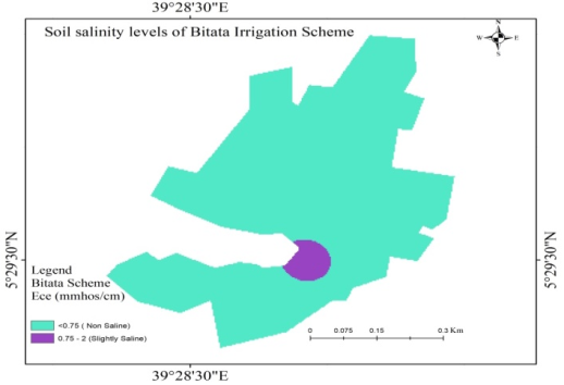
3.1. Soil Salinity of Bitata Irrigation Scheme
Soil Salinity Class of Bitata Irrigation Scheme fails under none saline and slightly saline as
| [7] | FAO (Food and Agricultural Organization). 2008. Guide to laboratory establishment for plant nutrient analysis, fertilizer and plant nutrition bulletin 19 Rome, Italy. |
[7]
of Criteria for identifying intensity of salinity and sodicity levels in soil. After spatial analyst and interpolation by Inverse distance Weight and Re-class it, the area of influence of the points was determined and arranged as the
figure 1.
Figure 1. Interpolated map of salinity concentration based on Ece of Bitata irrigation scheme.
As depicted from the figure above. The area of the classification coverage was as the next table.
Table 2. Classification of salinity level and area coverage based on (ECe) of Bitata Irrigation schemes.
Parameter used | Extent of Salinity | Area Coverage |
ECe (mmhos/cm) | Intensity of salinity levels in the soil | Hectares | Percent (%) |
< 0.75 | Non Saline | 31.3 | 97.5 |
0.75 - 2 | Slightly Saline | 0.8 | 2.5 |
As shown from
table 2, the majority of the area failed under non saline. And small under slightly saline depends on parameter used. Many researchers around the globe have documented their findings on the negative impact of soil salinity on physiological and metabolic activities of most agricultural crops
| [8] | Asfaw, E, Suryabhagavan, K, & Argaw, M. (2018). Soil salinity modeling and mapping using remote sensing and GIS: the case of wonji sugar cane irrigation farm, Ethiopia. Journal of the Saudi Society of Agricultural Sciences. |
| [9] | Jouyban, Z. (2012). The Effects of Salt Stress on Plant Growth. Technical Journal of Engineering and Applied Sciences, 2, 7-10. http://tjeas.com/ |
| [10] | Mensah, P. A. Akomeah, B. Ikhajiagbe and E. O. Ekpekurede. (2006). Effects of salinity on germination, growth and yield of five groundnut genotypes• Department of Botany, Ambrose Alli University, P.M.B. 14, Ekpoma, Nigeria. |
| [11] | Nasri, N., Saïdi, I., Kaddour, R. and Lachaâl, M. (2015). Effect of Salinity on Germination, Seedling Growth and Acid Phosphatase Activity in Lettuce. American Journal of Plant Sciences, 6, 57-63. |
[8-11]
. Soil salinity can be created either from rock and mineral weathering or from buildup of salts as a result of irrigation under poor drainage
| [12] | Chhabra, R. (2017). Soil salinity and water quality. Routledge. |
[12]
. The Soil salinity affects growth of plants by the osmotic pressure created within the plants, which delay the plant roots to take water smoothly
| [13] | DL Corwin, SM Lesch, 2003. Application of Soil Electrical Conductivity to Precision Agriculture: Theory, Principles, and Guidelines. Agronomy journal. |
[13]
. The concentration of salts in soil solution can also limit plant growth by creating toxicity or nutrient imbalance in the root zone
). Due to slightly saline soil occurred in the study area, the communities of the area and concerned bodies have to do on the control of its increments.
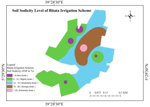
3.2. Soil Sodcity of Bitata Irrigation Scheme
The soil Sodicty classification of Bitata irrigation scheme was done following
| [15] | Amrhein C. 1996. Australian sodic soils: Distribution, properties, and management. Soil Science 161. |
[15]
and the result was as the
figure 2.
As shown from the
figure 2, the major area failed under slightly and moderately sodic respectively and followed by strongly and non-sodic. The extremely sodic was the least area coverage. The summary of soil sodicty area coverage of Bitata irrigation scheme based on ESP (%) was arranged as
table 3.
Figure 2. Interpolated map of sodicity concentration based on ESP of Bitata irrigation Scheme.
Table 3. Summary of area coverage of sodicity level classification based on ESP (in %).
Parameter used | Degree of Sodicity | Area Coverage |
ESP (%) | Intensity level of Sodicity | Hectare | Percent (%) |
<6 | Non-Sodic | 0.8 | 2.49 |
6 - 10 | Slightly Sodic | 12.6 | 39.25 |
10 - 15 | Moderately Sodic | 12.5 | 38.94 |
15 - 25 | Strongly Sodic | 5.7 | 17.76 |
>30 | Extremely Sodic | 0.5 | 1.56 |
Even if its distribution values varied entire the scheme the sodicity level from slightly to extremely were observed. And cover the major area of the study scheme. These results show that the studied scheme was affected by Sodicity problem.
Classification of salt affected soils based on the chemical properties of three major parameters following as stated by
| [6] | Richards, L. A. (ed.) (1954) Diagnosis and Improvement of Saline and Alkali Soils. Agriculture HandbookNo. 60. United States Department of Agriculture, Washington, DC. |
[6]
and the results observed on each sampling points as the
table 4.
Table 4. Salt affected of surface soil results of the study area.
Sampling | Parameters used for salt affected soil analysis and results obtained |
Numbers | (ECe) at 25°C (mmhos/cm) | (ESP %) | Reaction (Ph) values | salt affected Soil |
1 | 0.51 | 5.77 | 6.26 | non saline non sodic |
2 | 0.36 | 4.25 | 6.38 | non saline non sodic |
3 | 0.24 | 7.23 | 7.17 | non saline non sodic |
4 | 0.75 | 16.99 | 6.57 | Sodic |
5 | 0.2 | 7.66 | 7.18 | non saline non sodic |
6 | 0.2 | 3.62 | 7.05 | non saline non sodic |
7 | 0.28 | 30.47 | 7.31 | sodic |
8 | 0.32 | 24.28 | 6.46 | sodic |
9 | 0.91 | 11.39 | 7.68 | non saline non sodic |
10 | 0.48 | 5.54 | 7.03 | non saline non sodic |
As observed from
table 4, from ten sampling points, seven results show non saline non Sodic. While three outcomes show sodic. Even though the major area of the study failed under non saline non sodic, even if the results of three samples not match with as stated by
| [6] | Richards, L. A. (ed.) (1954) Diagnosis and Improvement of Saline and Alkali Soils. Agriculture HandbookNo. 60. United States Department of Agriculture, Washington, DC. |
[6]
with comparing three parameters, by two parameters fulfill guidelines and by one approach to it. Do to that, the three samples taken as sodic. Sodic soil also occurred in the area considering the three major parameters. Sodic soils are low in soluble salts than saline or saline sodic soils but high in exchangeable Na. The soil solution of sodic soils, although relatively low in soluble salts, has a composition that differs considerably from that of normal and saline soils. These soils contain HCO3
- and CO3
2- as the dominant anions. At high pH readings and in the presence of carbonate ions, Ca
2+ and Mg
2+ are precipitated. Hence, the soil solutions of sodic soils usually contain only small amounts of Ca
2+ and Mg
2+ but high amount of Na+. In addition, when the plants extract the water from the soil; the salts remain and become concentrated. This concentration causes the calcium to precipitate as calcium carbonate, while much of the Na remains in the soil water
| [16] | Mahmoodabadi, M., Yazdanpanah, N., Sinobas, L. R., Pazira, E., & Neshat, A. (2013). Reclamation of calcareous saline sodic soil with different amendments (I): Redistribution of soluble cations within the soil profile. Agricultural water management, 120, 30-38. |
[16]
. The main causes of salinity are shallow groundwater tables and natural saline seeps means when the groundwater intersects the soil surface and saline scalps (where water is lost by evaporation), Poor drainage and lack of appropriate irrigation water management is also known to facilitate secondary salinization, Improperly planned irrigation projects not supported by improved irrigation and drainage management technologies had invited serious degradation causing salinity and sodicity problems. The poor irrigation water management and lack of proper drainage caused the sodicity to the study area. So, management of the scheme should be increased by community of the area. And intervention for sodic soil management is necessaries for the study area to control the expansion of sodicity. Soils are referred to as being acid, neutral, or alkaline, depending on their pH, with 7 being neutral, below 7 acidic and above 7 alkaline. The ph range normally found in soils varies from 3 to 9. As pH is measured in terms of hydrogen ion activity, pH is thus a measure of only the intensity of H
+ activity and not the amount of acidity present. The desirable soil pH range for optimum plant growth varies among crops. Generally, a soil pH between 6.0-7.5 is acceptable for most plants, as most nutrients are available in this pH range. However, some plants have soil pH requirements above or below this range. An acidic pH may cause higher mobility of toxic elements potentially leaching into ground water or taken up and accumulated in plants. Additionally, inhibited plant growth may be observed in low pH soils due to aluminum toxicity. In higher pH soils, phosphorus and most micronutrients may become less available
| [17] | FAO. 2021. Standard operating procedure for soil pH determination. Rome. |
[17]
. In line with these the study area soil Ph result were shows acceptable for most plants. Except one sample result show out of range but very approach to the upper limit of the acceptance for most plants.
Exchangeable bases, namely, potassium (K), calcium (Ca), magnesium (Mg), and sodium (Na) are extracted from the soil usually by the use of neutral normal ammonium acetate
| [18] | Schollenberger, C. J., and Simon, R. H. 1945 Determination of exchange capacity and exchangeable bases in soils - 2nunoniurn acetate method. Soil Sci. 59: 13-24. |
[18]
, in which NH4
+ cation is used as the exchange cation for extracting basic cations. The potassium values of 0.38 to 0.5 are medium rating, while, 0.7 to 1.05 high and 1.79 and 2.78 very high, the calcium values of less than 2 shows very low, 2.69 and 3.46 are low, and the magnesium value of 0.77 is low, 1.15 to 2.69 are medium, 3.46 to 5.38 are high rating, and the sodium values of 0.2 to 0.26 indicate low, 0.3 to 0.5 medium and 1.13 (cmol (+) kg soil–1) shows high rating
| [19] | Food and Agriculture Organization (FAO). 2006. Plant nutrition for food security: A guide for integrated nutrient management. FAO, Fertilizer and Plant Nutrition Bulletin 16, Rome. |
[19]
.
Cation exchange capacity (CEC) is the ability of a soil to attract and retain cations such as potassium (K) sodium (Na), calcium (Ca), magnesium (M), ammonium (NH4), etc. Cation exchange capacity is influenced mainly by pH for soils dominated by variable charge colloids. Neutral ammonium acetate (1 N NH4C2H3O2, Ph. 7.0) is most commonly used to estimate soil cation exchange capacity through exchanging all cations by NH4+ ions.
Cation exchange capacity is reported as centimoles of positively charged ions retained per kg of soil (cmol(+) kg soil–1). Values of CEC are in the range of 1.0 to 100 cmol (+) kg soil–1, least for sandy soils and most for clay soils
| [20] | Food and Agriculture Organization (FAO). 1990. Guidelines for soil description. 3rd Ed. (revised). Soil Resources, Management and Conservation Service, Land and Water Development Division. FAO, Rome. 70 pp. |
| [21] | Landon, J. R. (Ed.). (1991). Booker tropical soil manual: A handbook for soil survey and agricultural land evaluation in the tropics and subtropics. Longman Scientific and Technical. |
[20, 21]
. The result of the soil CEC of Bitata irrigation scheme less than 5 demonstrate very low, from 5.37 to 10.56 are low rating and represent the major soil sample results and 25.7 show high rating as
| [21] | Landon, J. R. (Ed.). (1991). Booker tropical soil manual: A handbook for soil survey and agricultural land evaluation in the tropics and subtropics. Longman Scientific and Technical. |
[21]
. Organic materials such as composts and manures as well as salt-tolerant cover crops can be helpful in maintaining surface soil structure/aggregation for adequate infiltration and completion of the reclamation process
. Continued monitoring of salinity and sodicity is also recommended. As with, saline soil reclamation, adequate drainage must be maintained for both sodic and saline-sodic soils to flush sodium out of the system
| [23] | Horneck, D. A., J. W. Ellsworth, B. G. Hopkins, D. M. Sullivan, and R. G. Stevens. 2007. Managing salt-affected soils for crop production. A Pacific Northwest Extension Publication: Oregon State University, University of Idaho, and Washington State University PNW 601-E. |
[23]
.
3.3. Pit Profile Salinity Status of Bitata Irrigation Scheme
To see the soil salinity classes of profile across soil depth of the study area two pits were opened and the following results were obtained depends on guidelines stated by
| [6] | Richards, L. A. (ed.) (1954) Diagnosis and Improvement of Saline and Alkali Soils. Agriculture HandbookNo. 60. United States Department of Agriculture, Washington, DC. |
[6]
.
Table 5. Salinty Characters of Bitata irrigation Scheme across soil depth.
Opened pit | Depth | Parameters used | Salt Affected Soil |
Pit No. | cm | ECe (mmhos/cm) | ESP (%) | PH | Salinity Class |
P1 | 0-30 | 0.2 | 4.17 | 6.57 | non saline non sodic |
30-60 | 0.32 | 3.36 | 7.6 | Non saline non sodic |
60-90 | 0.27 | 5.23 | 6.38 | non saline non sodic |
90-120 | 0.24 | 7.89 | 7.07 | Non Saline non Sodic |
P2 | 0-30 | 0.16 | 7.14 | 7.07 | non saline non sodic |
30-60 | 0.24 | 4.31 | 6.89 | non saline non sodic |
60-90 | 0.32 | 5.67 | 6.73 | Non saline non sodic |
90-120 | 0.28 | 4.8 | 7.17 | non saline non sodic |
As depicted on
table 5, the soil results were show non saline non sodic across the soil profile when considering the three parameters at once. But when considering the individual parameters, the electrical conductivity of saturation extract is non saline as
| [24] | Food and Agricultural Organization (FAO), 2008. Classification of the intensity of salt problems in the soil, Rome, Italy. |
[24]
and the Exchangeable sodium percentage result show slightly sodic as in line with
| [15] | Amrhein C. 1996. Australian sodic soils: Distribution, properties, and management. Soil Science 161. |
[15]
. The ph of the soil values 6.38 to 7.6 are observed across the soil profile. These results show approach to neutral and alkalinity.
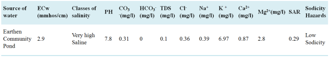
3.4. Irrigation Water Quality of Bitata Irrigation Scheme
The quality of water is an important component of the sustainable use of water for irrigated agriculture, especially when salinity development is expected to be a problem in an irrigated agricultural area. In this study the three basic criteria were used for evaluating water quality for irrigation purposes: total content of soluble salts (salinity hazard), relative proportion of sodium (Na+) to calcium (Ca2+) and magnesium (Mg2+) ions knowns as sodium adsorption ratio.
The Water used for irrigation can vary greatly in quality depending upon the type and quantity of dissolved salts. Salts are present in irrigation water in relatively small but significant amounts. As a result, there is no set limit on water quality; rather, its suitability for use is determined by the conditions of use that affect the accumulation of the water constituents and which may restrict crop yield. Several measurements are used to classify the suitability of water for irrigation including the ECw, TDS and SAR
| [25] | Bauder, T. A., Waskom, R. M., P. L. Sutherland and. Davis, J. G. 2011. Irrigation Water Quality Criteria. Fact Sheet No. 0.506 Crops. Colorado State University Extension. Revised 03/07. USA. www.ext.colostate.edu |
[25]
.
The concentration and composition of dissolved salts in any water determine its quality for irrigation. Mostly, the concerns with irrigation water quality relate to the possibility of high salt concentrations, sodium hazard, and carbonate and bicarbonate hazard. The analyses required for determining water quality include EC and soluble anions and cations. As depicted from the
table 6 the analysis result of irrigation water source sample collected from Bitata irrigation Scheme, there was result observed very high saline and low sodicity class of irrigation water. These shows there were potential for water infiltration problem
| [26] | Modified from R. S. Ayers and D. W. Westcot. 1994. Water Quality for Agriculture, Irrigation and Drainage Paper 29, rev.1, Food and Agriculture Organization of the United Nations, Rome. |
[26]
. The salinity hazard of irrigation water based upon conductivity of Bitata small scale irrigation Scheme was moderate as
| [27] | Megersa Olumana and Dilsebo, H. (2010a). Analyzing the extents of Basaka Lake Expansion and Soil and Water Quality Status of Metahara Irrigation Scheme, Awash Basin (Ethiopia), PhD Thesis. BOKU University, Vienna, Austria. |
[27]
. Regarding salinity and sodicity, irrigation water results obtained concede with
| [28] | Shaw, R., Brebber, L., Ahern, C. and Weinand, M., 1994. A review of sodicity and sodic soil behavior in Queensland. Soil Research, 32(2), pp. 143-172. |
[28]
. So, it is necessary to give great attention to irrigation water quality that used for irrigation purpose.
4. Summary and Conclusion
The assessment of soil and water salinity and Sodicity Status of Bitata small scale irrigation scheme investigation shows the results of surface soils and pit profiles were not the same. And the results of surface soil and water are also far apart from each other. The outcomes of the study show the problems of sodicity by considering the three parameters at once. Such as Electrical conductivity of saturation extracts, Exchangeable sodium percentage and potential of Hydrogen. But, when considering them individually the results shows slightly saline depends on Electrical conductivity of saturation extracts, considering the exchangeable sodium percentage, slightly to extremely sodic results was observed. And the quality of irrigation water used shows very high saline and low sodicity.
5. Recommendation
Based on the finding of soil and water salinity and sodicity status assessed on Bitata small scale irrigation Scheme, the following recommendation forwarded:
1) Management techniques that enhance soil fertility (counting:- crop rotations, manuring, fallow periods, proper management of crop residues, vermicomposting and leguminous cover crops and water-saving irrigation technologies suitable to the land of the area are the best options to enhance land productivity in the study area.
2) Due to the ECe was in class of non-saline to moderately saline, physical amendment (land leveling, smoothing, and Seed bed shaping) and Efficient use of irrigation water by irrigation schedule and measurement were recommended.
3) Training farmers on irrigation water management, drainage, surface irrigation methods, and irrigation type is necessary.
4) It is necessary to give great attention to irrigation water quality that used for irrigation purpose.
5) Due to the water results show, both saline and sodic, growing salt-tolerant crops would be better than making costly salinity problems.
6) Due to the surface soil results of the study area shows the sodicity characters, the physical and biological amendments are better than Chemical for now. But, in the future when show increments are after similar studies. Gypsum is the most effective amendments for salt problematic soils.
7) Farther research is necessary to justify the results of surface soil, across depth and water used for irrigation for more and strong recommendation. It is because of their results were far apart from each other as the studies shows.
Acknowledgments
We would like to especial acknowledge Ethiopian Agricultural Research Council Secretariat (EARCS), Small Scale Irrigation Development Directorate Ministry of Agriculture (MoA) for financing the study. And Oromia Agricultural Research Institute, Agricultural Engineering Research Directorate for sharing the ideas and technical supports and Bore Agricultural Research Center for logistic and material support provided during whole activity done. And we provide special thanks to Batu Soil Research Center for soil and water analyzing support. At the end, the authors thank editorial assistant and Reviewers for their critical review, appreciated comments and professional involvements that immensely contributed to the accomplishment of the paper for publication.
Abbreviations
PH | Potential of Hydrogen |
EC | Electrical Conductivity |
CEC | Cation Exchange Capacity |
GPS | Geographical Position System |
GIS | Geographical Information System |
ESP | Exchangeable Sodium Percentage |
SAR | Sodium Adsorption Ratio |
ECe | Electrical Conductivity of Saturation Extracts |
ECw | Electrical Conductivity of Water |
TDS | Total Dissolved Solids |
Conflicts of Interest
The authors declare no conflicts of interest.
Appendix
Table A1. Surface Soil Chemical parameters analyzed and their results.
Sampling points | Parameters analyzed and results obtained |
longitude | latitude | EC | CEC | Exch.Na | Exch.K | ca | mg | ECe mmhos/cm | ESP |
39.476 | 5.4908 | 0.13 | 8 | 0.3 | 1.05 | 2.69 | 1.54 | 0.51 | 5.77 |
39.4765 | 5.4944 | 0.09 | 7 | 0.26 | 0.77 | 1.54 | 3.84 | 0.36 | 4.25 |
39.4753 | 5.491 | 0.06 | 9.8 | 0.22 | 0.7 | 0.77 | 1.54 | 0.24 | 7.23 |
39.4775 | 5.4926 | 0.19 | 3.65 | 0.39 | 0.38 | 1.15 | 0.77 | 0.75 | 16.99 |
39.4757 | 5.4937 | 0.05 | 5.57 | 0.39 | 0.5 | 1.15 | 3.46 | 0.2 | 7.66 |
39.4773 | 5.4954 | 0.05 | 10.56 | 0.35 | 0.78 | 3.46 | 5.38 | 0.2 | 3.62 |
39.4776 | 5.4938 | 0.07 | 7.06 | 1.13 | 1.79 | 0.77 | 1.15 | 0.28 | 30.47 |
39.4781 | 5.4946 | 0.08 | 6.66 | 1.13 | 2.74 | 0.38 | 1.54 | 0.32 | 24.28 |
39.4773 | 5.4917 | 0.23 | 25.73 | 0.5 | 0.93 | 0.77 | 2.69 | 0.91 | 11.39 |
39.4787 | 5.4931 | 0.12 | 7.1 | 0.2 | 0.84 | 0.77 | 1.92 | 0.48 | 5.54 |
References
| [1] |
Tessema G (2011). Management of Salt Affected Soils. Soil Analysis for Soil Salinity and Fertility Status. VDM Publishing House Ltd. Verlag Dr. Muller GmbH and Co. KG. Germany. pp. 84.
|
| [2] |
Awulachew SB, Yilma AD, Loulseged M, Loiskandl W, Ayana M, Alamirew T (2007). Water Resources and Irrigation Development in Ethiopia. Working Paper 123. Colombo, Sri Lanka: International Water Management Institute. pp. 78.
|
| [3] |
Al-Ghobari, H. M. 2011. Effect of irrigation Water quality on soil properties and water uniformity under center pivot systems in central region of Saudi Arabia. Australian Journal of Basic and Applied Sciences, 5(7): 72-80 (ISI).
|
| [4] |
Jackson, M. L. (1973) Soil Chemical Analysis. Prentice Hall of India Pvt. Ltd., New Delhi, 498.
|
| [5] |
Okalebo, J. R., Gathua, K. W. and Woomer, P. L. (2002) Laboratory Methods for soil and Plant Analysis: A Working Manual. TSBF, Nairobi.
|
| [6] |
Richards, L. A. (ed.) (1954) Diagnosis and Improvement of Saline and Alkali Soils. Agriculture HandbookNo. 60. United States Department of Agriculture, Washington, DC.
|
| [7] |
FAO (Food and Agricultural Organization). 2008. Guide to laboratory establishment for plant nutrient analysis, fertilizer and plant nutrition bulletin 19 Rome, Italy.
|
| [8] |
Asfaw, E, Suryabhagavan, K, & Argaw, M. (2018). Soil salinity modeling and mapping using remote sensing and GIS: the case of wonji sugar cane irrigation farm, Ethiopia. Journal of the Saudi Society of Agricultural Sciences.
|
| [9] |
Jouyban, Z. (2012). The Effects of Salt Stress on Plant Growth. Technical Journal of Engineering and Applied Sciences, 2, 7-10.
http://tjeas.com/
|
| [10] |
Mensah, P. A. Akomeah, B. Ikhajiagbe and E. O. Ekpekurede. (2006). Effects of salinity on germination, growth and yield of five groundnut genotypes• Department of Botany, Ambrose Alli University, P.M.B. 14, Ekpoma, Nigeria.
|
| [11] |
Nasri, N., Saïdi, I., Kaddour, R. and Lachaâl, M. (2015). Effect of Salinity on Germination, Seedling Growth and Acid Phosphatase Activity in Lettuce. American Journal of Plant Sciences, 6, 57-63.
|
| [12] |
Chhabra, R. (2017). Soil salinity and water quality. Routledge.
|
| [13] |
DL Corwin, SM Lesch, 2003. Application of Soil Electrical Conductivity to Precision Agriculture: Theory, Principles, and Guidelines. Agronomy journal.
|
| [14] |
Tester, M. and Davenport, R. (2003) Na+ Tolerance and Na+ Transport in Higher Plants. Annals of Botany, 91, 503-527.
http://dx.doi.org/10.1093/aob/mcg058
|
| [15] |
Amrhein C. 1996. Australian sodic soils: Distribution, properties, and management. Soil Science 161.
|
| [16] |
Mahmoodabadi, M., Yazdanpanah, N., Sinobas, L. R., Pazira, E., & Neshat, A. (2013). Reclamation of calcareous saline sodic soil with different amendments (I): Redistribution of soluble cations within the soil profile. Agricultural water management, 120, 30-38.
|
| [17] |
FAO. 2021. Standard operating procedure for soil pH determination. Rome.
|
| [18] |
Schollenberger, C. J., and Simon, R. H. 1945 Determination of exchange capacity and exchangeable bases in soils - 2nunoniurn acetate method. Soil Sci. 59: 13-24.
|
| [19] |
Food and Agriculture Organization (FAO). 2006. Plant nutrition for food security: A guide for integrated nutrient management. FAO, Fertilizer and Plant Nutrition Bulletin 16, Rome.
|
| [20] |
Food and Agriculture Organization (FAO). 1990. Guidelines for soil description. 3rd Ed. (revised). Soil Resources, Management and Conservation Service, Land and Water Development Division. FAO, Rome. 70 pp.
|
| [21] |
Landon, J. R. (Ed.). (1991). Booker tropical soil manual: A handbook for soil survey and agricultural land evaluation in the tropics and subtropics. Longman Scientific and Technical.
|
| [22] |
Davis, J. G., R. M. Waskom, and T. A. Bauder. 2014. Managing sodic soils. Colorado State University Extension Publication no. 0.504.
www.ext.colostate.edu/pubs/crops/00504.html
|
| [23] |
Horneck, D. A., J. W. Ellsworth, B. G. Hopkins, D. M. Sullivan, and R. G. Stevens. 2007. Managing salt-affected soils for crop production. A Pacific Northwest Extension Publication: Oregon State University, University of Idaho, and Washington State University PNW 601-E.
|
| [24] |
Food and Agricultural Organization (FAO), 2008. Classification of the intensity of salt problems in the soil, Rome, Italy.
|
| [25] |
Bauder, T. A., Waskom, R. M., P. L. Sutherland and. Davis, J. G. 2011. Irrigation Water Quality Criteria. Fact Sheet No. 0.506 Crops. Colorado State University Extension. Revised 03/07. USA.
www.ext.colostate.edu
|
| [26] |
Modified from R. S. Ayers and D. W. Westcot. 1994. Water Quality for Agriculture, Irrigation and Drainage Paper 29, rev.1, Food and Agriculture Organization of the United Nations, Rome.
|
| [27] |
Megersa Olumana and Dilsebo, H. (2010a). Analyzing the extents of Basaka Lake Expansion and Soil and Water Quality Status of Metahara Irrigation Scheme, Awash Basin (Ethiopia), PhD Thesis. BOKU University, Vienna, Austria.
|
| [28] |
Shaw, R., Brebber, L., Ahern, C. and Weinand, M., 1994. A review of sodicity and sodic soil behavior in Queensland. Soil Research, 32(2), pp. 143-172.
|
Cite This Article
-
APA Style
Welde, O., Gragn, T. (2024). Assessment of Soil and Water Salinity Status of Bitata Small Scale Irrigation Scheme of Guji Zone Oromia, Ethiopia. International Journal of Environmental Protection and Policy, 12(3), 54-63. https://doi.org/10.11648/j.ijepp.20241203.11
 Copy
|
Copy
|
 Download
ACS Style
Welde, O.; Gragn, T. Assessment of Soil and Water Salinity Status of Bitata Small Scale Irrigation Scheme of Guji Zone Oromia, Ethiopia. Int. J. Environ. Prot. Policy 2024, 12(3), 54-63. doi: 10.11648/j.ijepp.20241203.11
Copy
|
Download
AMA Style
Welde O, Gragn T. Assessment of Soil and Water Salinity Status of Bitata Small Scale Irrigation Scheme of Guji Zone Oromia, Ethiopia. Int J Environ Prot Policy. 2024;12(3):54-63. doi: 10.11648/j.ijepp.20241203.11
Copy
|
Download
-
@article{10.11648/j.ijepp.20241203.11,
  author = {Obsa Welde and Tesfaye Gragn},
  title = {Assessment of Soil and Water Salinity Status of Bitata Small Scale Irrigation Scheme of Guji Zone Oromia, Ethiopia
},
  journal = {International Journal of Environmental Protection and Policy},
  volume = {12},
  number = {3},
  pages = {54-63},
  doi = {10.11648/j.ijepp.20241203.11},
  url = {https://doi.org/10.11648/j.ijepp.20241203.11},
  eprint = {https://article.sciencepublishinggroup.com/pdf/10.11648.j.ijepp.20241203.11},
  abstract = {The Soil salinity, sodicity and water logging are becoming an emerging challenge for the irrigation development. So, assessments of irrigation schemes are very important to see the problems they have. The assessment of soil and water salinity status of Bitata small scale irrigation scheme of Guji Zone, Oromia region was done to identify, analyze and map salinity level using Geographic information System, the chemical properties of the soil was done at laboratory for samples analysis. After, spatial analyst and interpolation by Inverse distance Weight and Re-class the soil analyzed. Then the area of influence of the points was determined for the selected parameters and the results of investigation shows the majority of sample results are non-saline non sodic, even if, the samples were less, the sodicity problems occur at the study area on surface soil by considering three parameters at once and non-saline and non-sodic for profile soil. And when considering individual parameters of surface soil the results shows slightly saline depends on Electrical conductivity of saturation extracts, considering the exchangeable sodium percentage slightly to extremely sodic results was observed. And the results of irrigation water quality shows Very high Saline and Low Sodicity. The finding of the study recommends intervention of sodicity for surface soil and salinity and sodicity for water source used for irrigation is very important to control the expansions of it to the whole area of the scheme and to minimize the risk of salinity and sodicity problems of the water source used for irrigation. Management techniques that improve soil fertility such as crop rotations, manuring, fallow periods, proper management of crop residues, vermicomposting and leguminous cover crops and water-saving irrigation technologies suitable to the land of the area are the best options. And similar work is necessary to get additional information of the study areas because of the results of surface and profile soil and water source used for irrigation were far apart from each other.
},
 year = {2024}
}
Copy
|
Download
-
TY  - JOUR
T1  - Assessment of Soil and Water Salinity Status of Bitata Small Scale Irrigation Scheme of Guji Zone Oromia, Ethiopia

AU  - Obsa Welde
AU  - Tesfaye Gragn
Y1  - 2024/06/19
PY  - 2024
N1  - https://doi.org/10.11648/j.ijepp.20241203.11
DO  - 10.11648/j.ijepp.20241203.11
T2  - International Journal of Environmental Protection and Policy
JF  - International Journal of Environmental Protection and Policy
JO  - International Journal of Environmental Protection and Policy
SP  - 54
EP  - 63
PB  - Science Publishing Group
SN  - 2330-7536
UR  - https://doi.org/10.11648/j.ijepp.20241203.11
AB  - The Soil salinity, sodicity and water logging are becoming an emerging challenge for the irrigation development. So, assessments of irrigation schemes are very important to see the problems they have. The assessment of soil and water salinity status of Bitata small scale irrigation scheme of Guji Zone, Oromia region was done to identify, analyze and map salinity level using Geographic information System, the chemical properties of the soil was done at laboratory for samples analysis. After, spatial analyst and interpolation by Inverse distance Weight and Re-class the soil analyzed. Then the area of influence of the points was determined for the selected parameters and the results of investigation shows the majority of sample results are non-saline non sodic, even if, the samples were less, the sodicity problems occur at the study area on surface soil by considering three parameters at once and non-saline and non-sodic for profile soil. And when considering individual parameters of surface soil the results shows slightly saline depends on Electrical conductivity of saturation extracts, considering the exchangeable sodium percentage slightly to extremely sodic results was observed. And the results of irrigation water quality shows Very high Saline and Low Sodicity. The finding of the study recommends intervention of sodicity for surface soil and salinity and sodicity for water source used for irrigation is very important to control the expansions of it to the whole area of the scheme and to minimize the risk of salinity and sodicity problems of the water source used for irrigation. Management techniques that improve soil fertility such as crop rotations, manuring, fallow periods, proper management of crop residues, vermicomposting and leguminous cover crops and water-saving irrigation technologies suitable to the land of the area are the best options. And similar work is necessary to get additional information of the study areas because of the results of surface and profile soil and water source used for irrigation were far apart from each other.

VL  - 12
IS  - 3
ER  -
Copy
|
Download