Abstract
The study area falls within the northwestern part of Nigeria and is underlain by crystalline rocks of the Basement Complex. Field mapping in Aberma and its environs were carried out using topographical map sheet of 54 SE Gusau on a scale 1: 25,000 with an area extends of about 30.8052km2. This field work was carried out using traverse method in conjunction with field equipment such as compass/clinometers, geologic hammer, sample bag and global positioning system. This study however, aims at producing a detail geological map, including the various rock geochemistry and petrography of the study area. The area is underlain by two major lithological rock type which is mica schist and granite gneiss. The granite gneiss is strongly foliated, caused by high temperature and pressure and the minerals observed in plane polarized light include quartz, orthoclase, plagioclase, muscovite, opaque mineral and biotite. The mica schists in the study area are mostly weathered in ditches below the ground surface, the rock is moderately weathered and show schistocyte. The minerals observed in plane polarized light include quartz and muscovite. The dominant structures observed include; joints, Quartz veins, foliation and pegmatite dyke. Structural analysis shows that the rocks have been affected by the Pan African orogeny with the joint’s orientation trending dominantly NNE-SSW and Quartz vein trending in somewhat E-W direction. The microscopic studies revealed that the mineralogical composition of the rocks types of the study area contain varying percentages of quartz, muscovite, plagioclase, orthoclase, opaque mineral and biotite as the major minerals. The geochemical analysis revealed the major and minor elemental distribution of the rock types of the study area. The chemical assay revealed that the granite gneiss and mica schist rock type of the study area are super-saturated with respect to silica, silica (SiO2) is the most abundant oxide with an average value of 78.12% in the rock sample. This implies that the rock analyzed is acidic in nature and must have formed from crystallization of an acidic magma because the silica content being greater than 65%.
|
Published in
|
Earth Sciences (Volume 13, Issue 3)
|
|
DOI
|
10.11648/j.earth.20241303.11
|
|
Page(s)
|
86-96 |
|
Creative Commons
|

This is an Open Access article, distributed under the terms of the Creative Commons Attribution 4.0 International License (http://creativecommons.org/licenses/by/4.0/), which permits unrestricted use, distribution and reproduction in any medium or format, provided the original work is properly cited.
|
|
Copyright
|
Copyright © The Author(s), 2024. Published by Science Publishing Group
|
Keywords
Rock Geochemistry and Petrography, Topographical Mapping, Quartz and Muscovite, Harker Diagram, Basement Complex, Fractional Segregation
1. Introduction
The study area falls within basement complex of Northwestern Nigeria
| [1] | Obaje, N. G, Wehner, H., Scheeder, G., Abubakar, M. B, Jauro, A. 2004. Hydrocarbon prospectivity of Nigeria’s inland basins: From the viewpoint of organic geochemistry and organic petrology. AAPG Bulletin, 88(3): 325–353; https://doi.org/10.1306/10210303022 |
[1]
. The Nigerian basement complex is a part of the pan African mobile belt which lies among the West African and Congo cratons as well as South of the Tuareg shield
| [2] | Black, R. 1980. Precambrian of West Africa. Episodes, 4: 3–8. |
[2]
according to Dada
| [3] | Dada, S. S. 2006. Proterozoic evolution of Nigeria. In: Oshi O (ed) The basement complex of Nigeria and its mineral resources (A Tribute to Prof. M. A. O. Rahaman). Akin Jinad and Company Ibadan, pp. 29–44. https://doi.org/10.1144/SP294.7 |
[3]
, The Nigerian basement occupies the reactivated Region as a result of the plate collision Between the passive continental margin of the West African Craton and the active Pharusian continental margins which Was affected by Pan-African Orogeny. Geological mapping is the process of gathering geological data in the field and adding that to a topographic map in order to create a geological map of that particular region. According to Njue
| [4] | Njue, L. M. (2010). Geological Field Mapping. A paper presented at Short Course V on Exploration for Geothermal Resources, organized by United Nations University- Geothermal Training Programme, Geothermal Development Company and KenGen, at Lake Bogoria and Lake Naivasha, Kenya. |
[4]
, a geological map will depict the various rock types of the region, the structures, geological formations, geothermal manifestations, age relationships, distribution of mineral ore deposits and fossils etc. and all these features may be super imposed over a topographic map or a base map. In general, it involves the careful observation of exposures, searching for other clues about the hidden geology, interpretation of these data in order to create the map and often, then writing a report to accompany the map. Actually, many authors
| [5] | Nwajide, C. S. 2000. Relevance of Geological Fieldwork to the Natural Resources Base. In leadership Forum Procceedings, Nigerian Association of Petroleum Explorationists- University Assisted Programme 2001-2006, pp. 21-22. |
| [1] | Obaje, N. G, Wehner, H., Scheeder, G., Abubakar, M. B, Jauro, A. 2004. Hydrocarbon prospectivity of Nigeria’s inland basins: From the viewpoint of organic geochemistry and organic petrology. AAPG Bulletin, 88(3): 325–353; https://doi.org/10.1306/10210303022 |
| [7] | Olayinka, A. I. 2009. Best practices in the planning and execution of geological field mapping, in Proceedings of Field Mapping Standardization Workshop, Lambert-Aikhionbare, D. O. and Olayinka, A. I. (Ed.). Ibadan University Press, Ibadan, pp. 27-47. |
| [4] | Njue, L. M. (2010). Geological Field Mapping. A paper presented at Short Course V on Exploration for Geothermal Resources, organized by United Nations University- Geothermal Training Programme, Geothermal Development Company and KenGen, at Lake Bogoria and Lake Naivasha, Kenya. |
| [9] | Saleh, M. B., and Maunde, A. 2017. Geologic settings and petrographic analysis of U Black, R. 1980. Precambrian of West Africa. Episodes, 4: 3–8. |
| [10] | Abaa SI (2014) The Structure and Petrography of alkaline rocks of the Made Younger Granite complex, Nigeria. Journal Afr. Earth Science. https://doi.org/10.1007/s00531-024-02401-1 |
| [11] | Akintola, O. F., Adekeye J. J (2008). Mineralization control and petrogenesis of rare metal pegmatites of Nasarawa area. Central Nigeria. Earth Science Red. Journal. Vol. 12(1). pp. 1-11. |
[5, 1, 7, 4, 9-11]
. etc.) have written immensely on geological field mapping but none has focused on this part of the state. Thus, a geological map is a map displaying the distribution of geological (rock) units and structures across a region, usually on a plane surface
The region of investigation (Aberma, and its environs) in close proximity to Bungudu town is a constituent of the North-Western Nigerian Basement Complex, which dates back to the Precambrian era. The Basement rocks of Nigeria can be categorized into three lithological units: the migmatite-gneiss-quartzite complex, the schist belts, and the older granites
| [6] | Danbatta, U. A. and Garba, M. L. 2007. Geochemistry and petrogenesis of Precambrian amphibolites in the Zuru schist belt, northwestern Nigeria. Journal of Mining and Geology, 43(1): 23–30. https://doi.org/10.4314/jmg.v43i1.18861 |
[6]
. The specific area under study comprises what is known as the "Older Granites" in the Northwest region of Nigeria
| [8] | Folorunso, A. F., Ayolabi, E. A., and Ariyo, S. O. 2013. Geological mapping, petrological study and structural analysis of precambrian basement complex rocks in part of Ago-Iwoye Southwestern Nigeria. International Research Journal of Geology and Mining (IRJGM), 3(1): 19-30. https://doi.org/10.4236/ijoc.2015.54026 |
[8]
.
2. Materials and Methods
2.1. Materials
Geological mapping of the study area involved the recognition, identification and measurement of the different rock types, structures and their mineral composition. Various mapping techniques were employed during the course of this exercise. These included
1. Field Notebook: Was used during the mapping exercise to record the available data in the field
2. Compass traversing pacing: To measure the dimension of outcrops, usage of compass-clinometer to determine strike and dip.
3. Global Positioning System (GPS) Device: To take coordinates and elevation of outcrops, wells and settlements.
4. Measuring tapes: To measure distances and depth of water table.
5. A Geological Hammer: Was used to collect fresh samples of rocks which were used for thin section analysis to determine the mineral content of the rocks.
6. A hand lens: Was used to undertake a preliminary field mineral identification before rock thin sections were made.
7. Maker and masking tape: The fresh samples collected from the field were labeled with a marker and masking tape and kept in a sample bag and transported to the laboratory for further analysis.
8. Enlarge base map: The use of topographic map in other to update the new geological map of the study area by inserting different lithologies. The base map use during the exercise has a scale of 1: 25,000 produced from enlargement of 1: 50,000 Sheet 54 (Gusau) SE.
9. Camera: Used for taking photograph of outcrop, structures, fractures e.t.c
10. Safety; the field require safety the mapping tools should be prepared including safety equipment it is very important, because we need to know anything may happen at the outside. Many dangerous things like reptiles or insect bites the rebound of rock particles while sampling, or hitting by hammer, it has probability to happen. so we should be well prepared. The standard suits to use are: Safety shoes, Safety glasses, Gloves, Field cap, Safety helmet (important if we go down to hole or cave)
2.2. Methods
A geological map of the region was thoroughly studied so as to get an idea of the important rock types and other significant geological characters of the ambience. The guidance of Supervisor was carefully listened so as to do better in the field. Important papers and documents were studied properly so that it would help in the field. So, in overall studies of the theoretical portions first was done.
2.2.1. Field Mapping and Methodology
The study area covering about 30.25km2 was mapped by the use of planimetric map for plotting locations, compass for taking bearing and the use of global positioning system (GPS) to get accurate location and also, pacing was employed in order to estimate distance (lateral extent of exposure). Different places suitable for the geological study were selected and their location was determined by the map and the observation related to such structures were taken and copied such as physical appearances, orientation, geological structures.
The work was done accordingly with the help of the Supervisor as all details were noted in the diary. The different rock types at various locations and their properties were noted down. The specimens were numbered and the location of the outcrop was marked in the map. Samples of each type of rocks were also collected. All the available information such as the changes in rock type or the structural characteristics of the outcrop seen was also recorded with the help of photographs and sketches along with text description. Various morphological structures of rivers were also studied there.
2.2.2. Sample Collection and Sample Preparation
Two samples were collected this is because the study area have almost the same lithology. Sampling interval for the rock samples varied depending on the lithology, textural grain size, extent of the aerial photograph of each outcrop and field environmental conditions encountered. These samples cover mainly mica schist and granite gneiss. Geochemical studies of rock samples were made in the Ahmadu Bello University Zaria (ABU) laboratory of geology in Zaria, Kaduna state. A total of two samples were taken for the geochemical analysis.
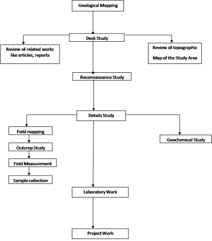
2.3. Summary of Workflow
The workflow approach used in this present study is illustrated in
Figure 1. The study involved five main stages namely desk study, preliminary (reconnaissance) survey, geological field work, laboratory analyses and report writing.
2.3.1. Desk Study
Reviews of literature and relevant reports were extensively carried out as well as procurement relevant of geological materials (the instrument used during this work include; field note book, measure tape, camera, maker measuring ruler, sample bag, enlarge base map, geological hammer, topographic map, compass and clinometers and global positional system)
2.3.2. Reconnaissance Study
Reconnaissance study was made to find out as much as possible about the geology of the study area as quickly as possible. This study however, was carried out to gather information basically based on the human activities as well as the possible mineral occurrences within the study area. The study includes a visual inspection of the site and its surrounding area, usually referred to as a walkover survey.
2.3.3. Detailed Study
The activities carried out under detailed study include the geological mapping, outcrop logging, taking field measurement, pre-mining studies and collection of samples for further analysis. Ten (10) outcrops were studied altogether within the study area. Actually, the present field work entails the collection of information outside a laboratory, library or workplace setting. Field research in the study area involves a range of well-defined, methods: informal interviews, direct observation, participation in the life of the group, collective discussions, analyses of personal documents produced within the group, self-analysis, results from activities undertaken off- or on-line, and life-histories.
2.3.4. Laboratory Work
Laboratory work was carried out in all the samples collected from the geological field work in the study area. The samples were collected at in-situ from the open-cast mine site, outcrops and coring area at different location with respect to depth.
2.3.5. Report Writing
Upon completion of the field work, then my group returned to elaborate the field observations in alliance with our supervisor. The works carried out include compilation and processing of accumulated field data and samples; interpretation of laboratory analyses done; systematic appraisal and evaluation of processed field data; digitization/production of maps and compilation of detailed project report.
3. Results
3.1. Geology of the Study
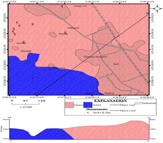
Figure 2. Geological map of the study area.
The study area is generally underlined by major rock units which include; Mica schists and Granite Gneiss. This is discussed under field, macroscopic, and microscopic description. The macroscopic description is studied in hand specimen while the microscopic description is studied both in plane polarized light (PPL) and cross polarized light (XPL) of a polarizing microscope. The rock is common crystalline basements rock that have been mapped in most part underlined by Nigerian basement complex.
3.2. Granite Gneiss
They are mainly fine grained to medium grained, biotite rich granitic rocks. They are also composed of white plagioclase some microcline, quartz and fairly abundant biotite. Hornblende is also present in varying amounts. The rock is fairly foliated, the foliation is expressed principally by sub-parallel arrangement of biotite
.
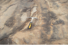
Figure 3. A Granite- gneiss exposure at 12°14’25” N to 06°38’36” E. c.
3.2.1. Field Description of Granite Gneiss
They are strongly foliated, caused by high temperature and pressure changes which led to the parallel arrangement of alternating light and dark-colored minerals. The protolith (granite) possibly metamorphosed into granite-gneiss to gneiss due to intense temperature and pressure conditions of regional metamorphism. The rock contains many deformational structures including Quartz veins, joints and faults. Petrographic Descriptions of gneiss: The minerals orthoclase feldspars and quartz are found interlocking as well as the biotite.
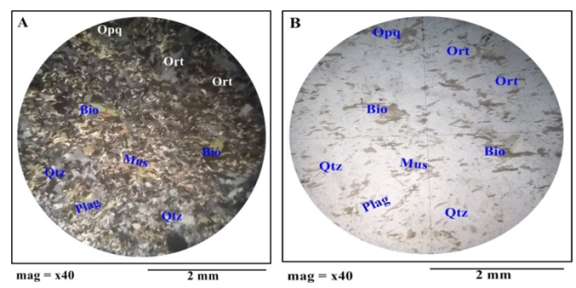
3.2.2. Microscopic Description of Fine-Medium Grained Granite Gneiss
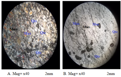
The minerals observed in plane polarized light (PPL) and under cross-polarizd light (XPL) include orthoclase, quartz, and biotite.
The orthoclase mineral constitutes about 15% of the rock (visual estimation)
| [12] | Ferere., Adekeye J. J (2008). Mineralization control and petrogenesis of rare metal pegmatites of Nasarawa area. Central Nigeria. Earth Science Red. Journal. Vol. 12(1). pp. 1-11. |
[12]
. Quartz crystals observed also constitute about 40% of the rock. However, Biotite crystals constitute about 10% of the rock and Brown color in both XPL and PPL (
Figure 4).
In addition to PPL, Quartz is the most abundant mineral present in the rock sample and it appears Blueish to milky in XPL and colorless to white in PPL. Orthoclase crystals is observed to be milky in XPL and colorless in PPL and up to about 15% of the rock. Biotite crystals constitute about 10% of the rock and Brown to dark color in XPL whereas dark in PPL.
Figure 4. Photomicrograph of migmatite (A) view in XPL (B) view in PPL.
In PPL view, biotite crystals have moderate relief, perfect cleavage, anhedral in shape and are pleiochroic. The rock contains very abundant brown elongations of biotite mineral spread all over having a well preferred orientation
| [13] | Iloeje, N. P. 2017. A new geography of Nigeria. Longman, Nigeria 201p. |
[13]
. In XPL view, the biotite has a moderate birefringence and an interference color of dark brown with patches of dark purple.
3.3. Schist
Schist stands as a metamorphic rock distinguished by its unique foliated arrangement, stemming from mineral grains aligning due to metamorphic processes. The term "schist" originates from the Greek word denoting "to split," underscoring the rock's propensity to effortlessly divide into thin sheets or layers along the foliation planes.
3.3.1. Field Description of Mica Schist
Figure 5. Mica Schist occur at low lying with coordinate 12° 11’ 38’’N 06° 37’ 64’’ E.
Schist represents a foliated metamorphic rock marked by visible layers or bands comprised of minerals. It showcases a variety of colors, often exhibiting a luster due to aligned mica minerals. The rock fractures along these layers and encompasses minerals like mica, quartz, feldspar, and possibly garnet or staurolite
| [11] | Akintola, O. F., Adekeye J. J (2008). Mineralization control and petrogenesis of rare metal pegmatites of Nasarawa area. Central Nigeria. Earth Science Red. Journal. Vol. 12(1). pp. 1-11. |
[11]
. Schist is typically found in regions undergoing intense metamorphism, exhibiting textures ranging from medium to coarse grains. It serves both ornamental and practical purposes.
3.3.2. Microscopic Description of Mica Schist
Mus=muscovite, Qtz=quartz, Plag=plagioclase. Under PPL lighting, foliated Muscovite flakes are interspersed by light brown materials, predominantly consisting of millimeter to centimeter-sized quartz crystals. The quartz appears colorless with minimal relief. Moreover, some muscovite displays impeccable basal cleavage. When observed under XPL, Muscovite exhibits a blue polarizing hue.
Figure 6. Photomicrograph of Mica Schist (A) view in XPL (B) view in PPL.
3.4. Geologic Structures of the Study Area
The structures associated with the different rocks can be grouped into two types;
3.4.1. Syn-Tectonic (Primary) Structures
These are structures formed during the time of emplacement of the rock body. They form concurrently with the emplacement of the rocks. Primary structures include; foliation, lineation etc.
3.4.2. Post -Tectonic (Secondary) Structures
These are structures formed after the rock has already been emplaced. The secondary structures observed in the study area include; joints, veins, and dykes.
Rocks in the study area are generally well exposed in some areas so that simple structural features such as joints, fractures, and quartz veins are conspicuously observed
| [14] | Garba, I. (1988). Introduction to Geology and Mineral Deposits of Nigeria. Ganuwa Publishers Series, Zaria. |
[14]
. The joints and fractures are formed probably as a result of brittle deformation while quartz veins observed on the outcrops are formed as a result of ductile deformation of rocks in the study area.
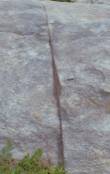
3.4.3. Joint
These are fractures along which there has been no displacement, joints formed from compression, tensional and shear stresses, they can range from microscopic to kms long in sizes. The granite exposures in the study area are characterized by several joint set which was observed at latitude 12
0 12’ 30
”N and longitude 06
0 37
’ 48
”E. Majority of the joint identified strikes in N-S direction, some of the joints are filled with crystals of minerals such as quartz, feldspar and biotite forming pegmatites and veins
| [15] | Danbatta, U. A. 2008. Precambrian crustal development in the northwestern part of Zuru schist belt, northwestern Nigeria. Journal of Mining and Geology. 44(1): 45-56. https://doi.org/10.4314/jmg.v44i1.18883 |
[15]
.
Figure 7. Field occurrence joint at the study area (12°12’37’’N, 06°36’17’’E).
Table 1. Trends of Quartz Veins in Coarse Biotite Granite of the Study Area.
S/N | LOCATIONS | CO’ORDINATES | SRIKE | DIP/DIRECTION |
| ABERMA | 12°11’4’’N 06°37’6.06’’E | 180° | 15° |
AWALAN VILLAGE | 12°12’48’’N 06°37’6.06’’E | 210° | 19° |
178° | 90° |
159° | 88° |
063° | 10° |
ALONG SHAISKAWA VILLAGE AWALA | 12°12’5’’N 06°36’47’’E | 180° | 13° |
ALONG AMADA VILLAGE | 12°12’39’’N 06°36’43’’E | 92° | 17° |
114° | 18° |
155° | 19° |
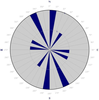
Figure 8. Rose diagram for Structures measured in the study area.
The data obtained from the field based on structural trends as measured from various outcrops of the study area reveal an average of 23.3° with strike and dip directions ranging from 015° and 13° -60° respectively. The rose diagram above reveals that structural trend within the study area is predominantly in the northern direction precisely at the northeastern (NE) which are in agreement with the general trend of structures in the basement complex (Ekeleme et al. 2017). This signifies that the line of mineralization will be in the northeastern direction.
3.5. Geochemistry of the Study Area
3.5.1. Introduction
The term “geochemistry” was first used by the Swiss chemist Schönbein in 1838. V. M. Goldschmidt, who is regarded as the founder of modern geochemistry, characterized geochemistry in 1933 with the following words:
“The major task of geochemistry is to investigate the composition of the Earth as a whole and of its various components and to uncover the laws that control the distribution of the various elements. To solve these problems, the geochemist needs a comprehensive collection of analytical data of terrestrial material, i. e. rocks, waters and atmosphere. Furthermore, he uses analyses of meteorites, astrophysical data about the composition of other cosmic bodies and geophysical data about the nature of the Earth’s inside. Much useful information also came from the synthesis of minerals in the lab and from the observation of their mode of formation and stability conditions.”
3.5.2. Geochemical Results for Mica Schists and Granite Gneiss of the Study Area
Under this section of the fourth chapter geochemical data is presented and its interpretation is discussed.
Table 2 shows the elemental data, in weight percentage, of the rock used for the geochemical analysis.
Table 2. Major elements compositions of rocks from the study area (values in wt%).
Rock Name/Elements (%) | Gneiss (wt %) | Mica Schist 1 (wt %) |
SiO2 | 78.12 | 61.42 |
Al2O3 | 12.37 | 14.89 |
Fe2O3 | 1.38 | 9.52 |
MnO | 0.03 | 0.54 |
MgO | 1.9 | 3.83 |
CaO | 0.79 | 0.96 |
Na2O | 0.12 | 0.24 |
K2O | 4.35 | 3.03 |
TiO2 | 0.63 | 0.6 |
P2O5 | 0.12 | 0.08 |
Total | 99.81 | 99.39 |
Table 3. Trace Elements Composition of the Rock Sample in the Study Area.
Element (PPM) | Gneiss | Mica Schist |
Ba | 258 | 522 |
Co | 15 | 19.8 |
Cs | 0.5 | 9.9 |
Cu | 12 | 34.4 |
Ga | 5 | 16.9 |
Ni | 16 | 49.2 |
Rb | 11 | 176.6 |
Sc | 3.8 | |
Sr | 20 | 25.1 |
Th | 3.7 | 7.8 |
U | 2 | 2.6 |
V | 33 | 103 |
Y | 15 | 28.7 |
Zn | 18 | 88 |
Zr | 28 | 158 |
La | 11 | 34.7 |
Ce | 16 | 93.9 |
Nd | 8 | 30.5 |
Sm | 2.2 | 6.01 |
Eu | 0.6 | 1.31 |
Tb | 0.5 | 0.87 |
Yb | 1.4 | 2.96 |
Lu | 0.21 | 0.45 |
4. Discussion
4.1. Major Element Composition
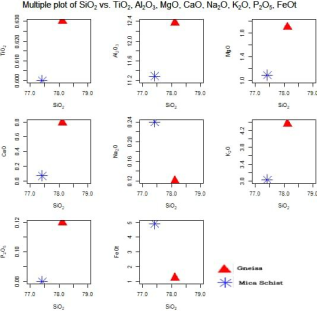
The major elements Geochemistry of the rocks of the study area is presented in
Table 3 The major rock types underlying the study area comprise of Mica Schist and granite gneiss. The chemical assay revealed that the granite and mica schist types of the study area are super saturated with respect to silica as they have composition of 78.12wt% - 61.42wt%. The second most dominant element constitute is Alumina (Al
2O
3) which revealed 12.37wt% - 14.89wt%. However, the geochemical analysis revealed low content of P
2O
5 (0.12wt%) in mica schist with the lowest content in granite (0.08wt%).
Figure 9. Showing the hacker diagram of the elements.
This concentration shows that the rocks are alumina – silicate of continental origin. Other element such as CaO, NaO
2 and K
2O revealed in weight percentage less than that of Al
2O
3 concentration in rock samples (see
Table 3), Alumino – silicate minerals; such as Quartz, feldspar and micaceous mineral. In addition, Na
2O remains consistently less than K
2O in all most all the rock sample as shown in
Table 3 to substitute it further the concentration of Fe
2O
3 element enrichment range between 1.38wt% - 9.52wt% and that of MgO range between 1.9wt% - 3.83 wt%. This indicates that the two rock samples are peralluminous in nature as concentration of Al
2O
3 greater than (MnO + TiO
2 + LOI) concentration. This it could be said that the rock samples were formed during syn – collision tectonic event of a major orogeny.
4.2. Economic Geology and Hydrogeology
4.2.1. Economic Geology
The geological material deposits of economic values available in the area mapped include alluvial deposits, Laterites, clay and rock aggregates. Though there was no record of any extensive and intensive investigation for ore minerals.
1. Alluvial Deposits:
Alluvial sands are found as detritus transported along river bed as product of weathering and erosion of the rocks. The alluvial sand contains much of quartz and little feldspar. Sands and gravels are used in conjunction with cement and water in construction of culverts and pavements along road sides. They are also used in making mud bricks for constructing mud houses.
2. Laterites and Clay:
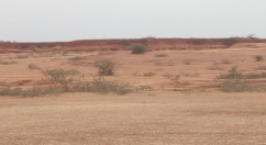
Laterite capping occurs in most of the study area. They are reddish brown with ferruginous concentrations. Laterite is formed from the laterization of rocks. It is both in consolidated and unconsolidated. Laterite is also presented in the mapped area. Laterite are formed as a result of chemical weathering of the parent rocks in - situ essentially if the parent rocks are rich in iron. Laterites are also useful construction works for building houses, road surfacing and filling of foundation. Laterite could also be smelted locally for iron production, but the iron ore content is low for commercial exploitation.
Figure 10. Photograph of Laterite of the Study Area with coordinate 120 11’21’’N 060 38’22’’ E.
4.2.2. Hydrogeology
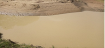
The importance of water cannot be overemphasized. Without it, life cannot exist. The importance of water is manifested in the study area in the way and manner in which its nature of distribution influences the settlement pattern. Their residence was not far from the river channels and also not too close to avoid flood during the dry season. Generally, the source of water in the study area is in two forms: the surface water and the groundwater. During the period of the geological mapping; which marks the onset of rainy season, little or no water was recorded, as most of the rivers appear dry.
(i). Surface Water
This includes rivers and streams. During the geological mapping, nearly all the rivers and stream channels in the area were with little or no water. This is because the river and streams are seasonal (water flow during the rainy season and is dried during the dry season) and there is high rate of evaporation and sub-surface seepage into the ground. However, the villagers in some parts of the area employ the strategy of digging shallow pits along these stream channels to reduce the scarcity of surface water during the dry season. The surface water in the study area is naturally replenished by precipitation (rainfall), and ground water also assists in its sustenance. The settlers in this area also make use of stream, and the Massibil dam water for irrigation farming and for livestock consumption.
Figure 11. Surface water with the coordinate Latitude 12º11'30"N and Longitude 06°37’41"E.
(ii). Ground Water
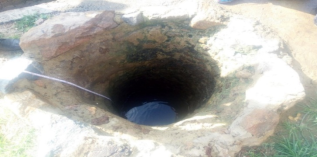
The ground water in the study area is sustained by the soft overburden and the fractured crystalline aquifers. The former is the product of the weathering of the underlying crystalline rocks. Hand-dug wells are the most well-known sources of water in the study area with the availability of borehole also in most part of the area. Groundwater serves as the only drinkable water.
Figure 12. Hand Dug Well In Abarma (12° 11’ 22”N 06°38’22 ”E)
5. Conclusions
The study area is located in Gusau Local Government area of Zamfara State and forms part of Federal Survey map of Nigeria sheet 54 SW, Zamfara State which falls within the Nigerian Basement Complex. It lies within the coordinates; latitude 12°11’0” N to 12°13’0”N and longitude 06°36’30”E to 06°39’30”E. covering an area of about 30.4 km2. The prominent settlements in the study area: Abarma, Madidi, Awalan, NNPC depot, Gidan Ali, etc. It was geologically mapped on a scale of 1: 25: 000.
Acknowledgments
My supervisor Dr. Isah Shaibu one of a kind. He is an epitome of purity, embodiment of knowledge, and a mentor to me. Thank you for your patience, your guidance and your cooperation. I have learnt a lot; may the Almighty continue to bless you and your entire family. To my lecturers who taught me Geology and also taught life, I am really grateful.
Author Contributions
Bello Aliyu is the sole author. The author read and approved the final manuscript.
Conflicts of Interest
The author declares no conflicts of interest.
References
| [1] |
Obaje, N. G, Wehner, H., Scheeder, G., Abubakar, M. B, Jauro, A. 2004. Hydrocarbon prospectivity of Nigeria’s inland basins: From the viewpoint of organic geochemistry and organic petrology. AAPG Bulletin, 88(3): 325–353;
https://doi.org/10.1306/10210303022
|
| [2] |
Black, R. 1980. Precambrian of West Africa. Episodes, 4: 3–8.
|
| [3] |
Dada, S. S. 2006. Proterozoic evolution of Nigeria. In: Oshi O (ed) The basement complex of Nigeria and its mineral resources (A Tribute to Prof. M. A. O. Rahaman). Akin Jinad and Company Ibadan, pp. 29–44.
https://doi.org/10.1144/SP294.7
|
| [4] |
Njue, L. M. (2010). Geological Field Mapping. A paper presented at Short Course V on Exploration for Geothermal Resources, organized by United Nations University- Geothermal Training Programme, Geothermal Development Company and KenGen, at Lake Bogoria and Lake Naivasha, Kenya.
|
| [5] |
Nwajide, C. S. 2000. Relevance of Geological Fieldwork to the Natural Resources Base. In leadership Forum Procceedings, Nigerian Association of Petroleum Explorationists- University Assisted Programme 2001-2006, pp. 21-22.
|
| [6] |
Danbatta, U. A. and Garba, M. L. 2007. Geochemistry and petrogenesis of Precambrian amphibolites in the Zuru schist belt, northwestern Nigeria. Journal of Mining and Geology, 43(1): 23–30.
https://doi.org/10.4314/jmg.v43i1.18861
|
| [7] |
Olayinka, A. I. 2009. Best practices in the planning and execution of geological field mapping, in Proceedings of Field Mapping Standardization Workshop, Lambert-Aikhionbare, D. O. and Olayinka, A. I. (Ed.). Ibadan University Press, Ibadan, pp. 27-47.
|
| [8] |
Folorunso, A. F., Ayolabi, E. A., and Ariyo, S. O. 2013. Geological mapping, petrological study and structural analysis of precambrian basement complex rocks in part of Ago-Iwoye Southwestern Nigeria. International Research Journal of Geology and Mining (IRJGM), 3(1): 19-30.
https://doi.org/10.4236/ijoc.2015.54026
|
| [9] |
Saleh, M. B., and Maunde, A. 2017. Geologic settings and petrographic analysis of U Black, R. 1980. Precambrian of West Africa. Episodes, 4: 3–8.
|
| [10] |
Abaa SI (2014) The Structure and Petrography of alkaline rocks of the Made Younger Granite complex, Nigeria. Journal Afr. Earth Science.
https://doi.org/10.1007/s00531-024-02401-1
|
| [11] |
Akintola, O. F., Adekeye J. J (2008). Mineralization control and petrogenesis of rare metal pegmatites of Nasarawa area. Central Nigeria. Earth Science Red. Journal. Vol. 12(1). pp. 1-11.
|
| [12] |
Ferere., Adekeye J. J (2008). Mineralization control and petrogenesis of rare metal pegmatites of Nasarawa area. Central Nigeria. Earth Science Red. Journal. Vol. 12(1). pp. 1-11.
|
| [13] |
Iloeje, N. P. 2017. A new geography of Nigeria. Longman, Nigeria 201p.
|
| [14] |
Garba, I. (1988). Introduction to Geology and Mineral Deposits of Nigeria. Ganuwa Publishers Series, Zaria.
|
| [15] |
Danbatta, U. A. 2008. Precambrian crustal development in the northwestern part of Zuru schist belt, northwestern Nigeria. Journal of Mining and Geology. 44(1): 45-56.
https://doi.org/10.4314/jmg.v44i1.18883
|
Cite This Article
-
APA Style
Aliyu, B. (2024). Geology and Geochemistry of Aberma and Its Environ Sheet 54se Gusau, Zamfara State, Nigeria. Earth Sciences, 13(3), 86-96. https://doi.org/10.11648/j.earth.20241303.11
 Copy
|
Copy
|
 Download
ACS Style
Aliyu, B. Geology and Geochemistry of Aberma and Its Environ Sheet 54se Gusau, Zamfara State, Nigeria. Earth Sci. 2024, 13(3), 86-96. doi: 10.11648/j.earth.20241303.11
Copy
|
Download
AMA Style
Aliyu B. Geology and Geochemistry of Aberma and Its Environ Sheet 54se Gusau, Zamfara State, Nigeria. Earth Sci. 2024;13(3):86-96. doi: 10.11648/j.earth.20241303.11
Copy
|
Download
-
@article{10.11648/j.earth.20241303.11,
  author = {Bello Aliyu},
  title = {Geology and Geochemistry of Aberma and Its Environ Sheet 54se Gusau, Zamfara State, Nigeria
},
  journal = {Earth Sciences},
  volume = {13},
  number = {3},
  pages = {86-96},
  doi = {10.11648/j.earth.20241303.11},
  url = {https://doi.org/10.11648/j.earth.20241303.11},
  eprint = {https://article.sciencepublishinggroup.com/pdf/10.11648.j.earth.20241303.11},
  abstract = {The study area falls within the northwestern part of Nigeria and is underlain by crystalline rocks of the Basement Complex. Field mapping in Aberma and its environs were carried out using topographical map sheet of 54 SE Gusau on a scale 1: 25,000 with an area extends of about 30.8052km2. This field work was carried out using traverse method in conjunction with field equipment such as compass/clinometers, geologic hammer, sample bag and global positioning system. This study however, aims at producing a detail geological map, including the various rock geochemistry and petrography of the study area. The area is underlain by two major lithological rock type which is mica schist and granite gneiss. The granite gneiss is strongly foliated, caused by high temperature and pressure and the minerals observed in plane polarized light include quartz, orthoclase, plagioclase, muscovite, opaque mineral and biotite. The mica schists in the study area are mostly weathered in ditches below the ground surface, the rock is moderately weathered and show schistocyte. The minerals observed in plane polarized light include quartz and muscovite. The dominant structures observed include; joints, Quartz veins, foliation and pegmatite dyke. Structural analysis shows that the rocks have been affected by the Pan African orogeny with the joint’s orientation trending dominantly NNE-SSW and Quartz vein trending in somewhat E-W direction. The microscopic studies revealed that the mineralogical composition of the rocks types of the study area contain varying percentages of quartz, muscovite, plagioclase, orthoclase, opaque mineral and biotite as the major minerals. The geochemical analysis revealed the major and minor elemental distribution of the rock types of the study area. The chemical assay revealed that the granite gneiss and mica schist rock type of the study area are super-saturated with respect to silica, silica (SiO2) is the most abundant oxide with an average value of 78.12% in the rock sample. This implies that the rock analyzed is acidic in nature and must have formed from crystallization of an acidic magma because the silica content being greater than 65%.
},
 year = {2024}
}
Copy
|
Download
-
TY  - JOUR
T1  - Geology and Geochemistry of Aberma and Its Environ Sheet 54se Gusau, Zamfara State, Nigeria

AU  - Bello Aliyu
Y1  - 2024/06/25
PY  - 2024
N1  - https://doi.org/10.11648/j.earth.20241303.11
DO  - 10.11648/j.earth.20241303.11
T2  - Earth Sciences
JF  - Earth Sciences
JO  - Earth Sciences
SP  - 86
EP  - 96
PB  - Science Publishing Group
SN  - 2328-5982
UR  - https://doi.org/10.11648/j.earth.20241303.11
AB  - The study area falls within the northwestern part of Nigeria and is underlain by crystalline rocks of the Basement Complex. Field mapping in Aberma and its environs were carried out using topographical map sheet of 54 SE Gusau on a scale 1: 25,000 with an area extends of about 30.8052km2. This field work was carried out using traverse method in conjunction with field equipment such as compass/clinometers, geologic hammer, sample bag and global positioning system. This study however, aims at producing a detail geological map, including the various rock geochemistry and petrography of the study area. The area is underlain by two major lithological rock type which is mica schist and granite gneiss. The granite gneiss is strongly foliated, caused by high temperature and pressure and the minerals observed in plane polarized light include quartz, orthoclase, plagioclase, muscovite, opaque mineral and biotite. The mica schists in the study area are mostly weathered in ditches below the ground surface, the rock is moderately weathered and show schistocyte. The minerals observed in plane polarized light include quartz and muscovite. The dominant structures observed include; joints, Quartz veins, foliation and pegmatite dyke. Structural analysis shows that the rocks have been affected by the Pan African orogeny with the joint’s orientation trending dominantly NNE-SSW and Quartz vein trending in somewhat E-W direction. The microscopic studies revealed that the mineralogical composition of the rocks types of the study area contain varying percentages of quartz, muscovite, plagioclase, orthoclase, opaque mineral and biotite as the major minerals. The geochemical analysis revealed the major and minor elemental distribution of the rock types of the study area. The chemical assay revealed that the granite gneiss and mica schist rock type of the study area are super-saturated with respect to silica, silica (SiO2) is the most abundant oxide with an average value of 78.12% in the rock sample. This implies that the rock analyzed is acidic in nature and must have formed from crystallization of an acidic magma because the silica content being greater than 65%.

VL  - 13
IS  - 3
ER  -
Copy
|
Download