Research Article | | Peer-Reviewed

Participatory Assessment of Agriculture Land and Vegetation Associated Issues and Possible Interventions in Gurage Zone, Ethiopia

Received: 16 April 2024     Accepted: 5 June 2024     Published: 23 July 2024
Views:       Downloads:
Abstract

Land degradation and depletion of natural forests made agriculture unsustainable and threaten communities and ecosystems as a whole. The objective of this participatory assessment was to identify researchable issues related to agricultural land and vegetation cover in Gurage zone. Accordingly, seven representative districts were selected and from each district two representative kebeles were purposively selected. Focus Group Discussion with farmers, development agents and subject matter specialists and direct observation were important primary sources of information. The survey result depicts in the Gurage zone land degradation, undulating steep slope topography, small and overwhelmed land tenure, inappropriate land use system, cultural landscape mismanagement, deforestation of indigenous trees and expansion of eucalyptus tree, and decreasing enset production are the major identified problems associated with land use and vegetation cover of the study area. In the mixed farming system, enset is produced as a homestead farm and its coverage is decreasing due to disease, lack of processing machines, and shortage of organic matter. Due to the expansion of eucalyptus and land use change, the majority of native trees are disappearing or decreasing in area coverage. Therefore, enset and eucalyptus require suitable policy attention. In the mountainous areas of Gurage; limited land availability, soil degradation, shortage of appropriate farm technologies, water scarcity, lack of knowledge for alpine agriculture and inconvenient topography for mechanized farming machines issues threaten agriculture of area. Despite the fact that there are few attempts to control land degradation; the issue still needs much attention. Appropriate agricultural technologies and knowledge suited for mountain agriculture, dense populations, enset-based farming systems, and small land tenure are important priority research focus areas for future research.

Published in American Journal of Agriculture and Forestry (Volume 12, Issue 4)
DOI 10.11648/j.ajaf.20241204.15
Page(s) 271-281
Creative Commons

This is an Open Access article, distributed under the terms of the Creative Commons Attribution 4.0 International License (http://creativecommons.org/licenses/by/4.0/), which permits unrestricted use, distribution and reproduction in any medium or format, provided the original work is properly cited.

Copyright

Copyright © The Author(s), 2024. Published by Science Publishing Group

Keywords

Land Degradation, Enset, Eucalyptus, Topography, Mountain Agriculture

1. Introduction
Land degradation, globally relevant environmental problem, that caused by human activities, and exacerbated by natural processes and one of the 21st century world agenda, viewed as any change or disturbance to land perceived to be undesirable that affect human activities like agriculture and settlements . Worldwide, 75 billion tonnes of soil are lost from arable land each year and an estimated $400 billion in agricultural production is lost . Land degradation problem occurs through both anthropogenic and natural activities, it can be chemical, physical biological degradation . The large areas are not affected by human intervention because the land is either unsuitable for agricultural activities (climatic, topographic and soil constraints) or poorly accessible . Even though the causes of land degradation in Ethiopia is complex and diverse, the major causes are cultivation on steep slopes, rapid population increase, severe soil loss, deforestation, low vegetative cover and unbalanced crop and livestock production urbanization, and intensive agricultural practices . Land degradation manifests itself in many different ways: vegetation becomes increasingly scarce, water courses dry up, thorny weeds predominate in once rich pastures, footpaths grow into gullies, and soils become thin and stony .
In Ethiopia 75% of the highlands are estimated to need soil conservation measures of one sort or another if they are to support sustained cultivation . Among soil degradations, soil erosion and acidity are the dominant problems in Gurage zone. Gurage highlands that stretch through Eastern Hadiya and Kembatta highlands, are some of the seriously eroded land surfaces in Ethiopia . In the current farming system, the association of topography and land use is important issue in the Gurage zone. Inappropriate land-use systems and land-tenure policies enhance desertification and loss of agrobiodiversity. Among all anthropogenic geomorphological features, agricultural terraces on slopes have the largest relief-modifying impact, equally affecting soil, climatic, hydrologic and biogeographic conditions .
As one of physical features the function of vegetation coverage is numerous, trees are important plants that have improved life through the provision of essential necessities and without vegetation coverage the land feature is always under threat. Gurage zone vegetation cover affected by the increasing population pressures and land use change . Analyses of land cover change show a trend of decreasing vegetation cover for three of five classes of wooded or forested land cover across the Gurage Zone between 1995 and 2011 . This clearly cause climate change, that affects households who are heavily dependent on natural resources and found in the lowland areas of the Gurage zone . Most of the Gurage zone agriculture is dependent on rain- fed agriculture, such a farming system is uncertain and vulnerable to climate change and extremes events .
In the Ethiopian highlands eucalyptus has long been advocated as a strategy for relieving pressure on indigenous forests and woodlands . In homestead farming woody and non-woody perennials crops have a significant contribution to household consumption and income generation . At present, in Gurage zone eucalyptus is expanding rapidly and has taken over a lot of agricultural and grazing land. According to enset serves as a staple food for about 20% of the Ethiopian population, over 20 million people, mainly in the south and south-west of the country. In Gurage Zone fertility status of the enset farm was found to be in the better stands , high genetic diversity . Efforts have been made to launch afforestation and conservation programs; however, success to date has been limited . The objective of this research was to identify agriculture land and vegetation associated issues in Gurage zone.
2. Materials and Methods
2.1. Description of the Study Area
Gurage Zone is found in the Southern Nations, Nationalities, and Peoples' Region of Ethiopia. The Zone is bounded with Hadiya and Silte Zones to the south, South West Shewa Zone to the north, Jimma Zone and Yem Special Woreda to west and East Shewa and Silte Zones to East directions. The elevation of the zone lies between 800 and 4000 meters above sea level. Geographically the zone is located between 7.44° - 8.29° North latitude and 37.29° - 38.43° East longitude (Figure 1).
Gurage zone covers an area of 6373.14 km2, of which 2.88% is characterized as Dry Kola, 2.7% as Moist Kola, 2.28% as Dry Woyenadega, 61.9% as Moist Woyenadega, 28.44% as Moist Dega and 1.8% as Worch (frost) agro ecologies. Regarding agroecology about 93% of the total area is considered suitable for agricultural production ranging from Dry Woyenadega to Moist Dega. However, the undulating landscape limit the suitability of cultivable land.
Based on the 2007 Central Statistics Agency (CSA) census the projection report of Gurage Zone Finance and Economic Development Department , the total population of Gurage Zone is estimated to be 1,947,438 and the proportion of women and men is 51.4% and 48.6%, respectively. The zone is among the most densely populated areas in the country (next to Wolaita and Hadiya), with an average of 309 people km-2 land area and mainly concentrated in the Dega and Woyna-Dega areas.
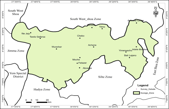
Figure 1. The boundary of Gurage Zone and Survey kebeles.
2.2. Research Procedure
Participatory assessment of agricultural land and vegetation-associated issues of Gurage zone was conducted in 2021. Discussions were held with higher officials and senior agricultural experts from Gurage Zone Agriculture Department based on prepared checklists. With the help of senior agricultural experts seven representative districts (Table 1) were purposively selected for the study. From each district, two representatives kebeles were selected (Table 1). For key informant discussion at each kebele, a group of farmers which consisted of 15-25 members was organized with the inclusion of both sex, different ages, and wealth groups in consultation with development agents and local administrators.
Table 1. The Information of representative sampling districts and Kebele.

Woredas

Kebeles

Altitude (m)

Longitude

Latitude

AEZ

Abeshge

Fite-Jeju

1549

37°59290’ E

08’32277° N

Kola

Tawla-Gefersa

1775

37°68657’ E

08’28196° N

Kola

Cheha

Wurerber

1930

37°84488’ E

08’17713° N

Weinadega

Moche

2579

38°01347’ E

08’06332° N

Dega

Gumer

Fetazer

2906

38°07781’ E

08’02156° N

Dega

Abesuja

2770

38°10481’ E

07’95782° N

Dega

Muhir-Aklil

Echene

2807

38°14467’ E

08’184130 N

Dega

Chebo

2074

38°05851’ E

08’289730 N

Weinadega

G/G/Welene

Tilamo

2646

38°23531’ E

08’399210 N

Dega

Deneb

2205

38°08431’ E

08’24110° N

Weinadega

East Meskan

Emerwacho

1864

38°28314’ E

08’09214° N

Kola

Bati-Lejano

1827

38°47639’ E

08’10252° N

Kola

Sodo

Adele-Borebor

1874

38°55504’ E

08’17263° N

Kola

Amawte-Giftge

2607

38°53221’ E

08’42965° N

Dega

2.3. Data Sources and Method of Collection
Before and after the survey discussions was made with development agents and subject matter specialists to collect additional information and to cross-check and strengthen the gathered information. Moreover, a one-day validation workshop was conducted and a summary of the draft manuscript was presented to the higher officials and senior experts from Gurage Zone and Districts Agriculture departments. The workshop has helped to triangulate the gathered information, and inclusion of issues that are important in the area but have been missed in the survey.
3. Result and Discussion
3.1. Land Associated Issues
Land Degradation
In the Gurage zone, different types of erosions are found to be the biggest challenges. Even though, erosion has been observed throughout the surveyed districts, the intensity was found to be high in Cheha, Gutazer Gedebano Wolene, Endegagn, Muhr Aklil, and Enemor districts. During the group discussions farmers and agricultural experts confirmed that currently soil erosion problem is increasing in extent and severity. The satellite picture below also illustrates unless a quick and appropriate measure has been taken due to soil erosion a large portion of land will be lost within a few years (Figure 2).
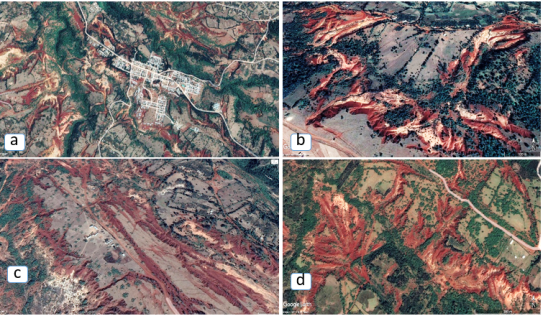
Figure 2. Land degradation google earth photo at Gurage zone a) Muhr Aklil District nearby Hawaryat town b) Muhr aklil District Korer kebele c) kokir Gedebano District Ameto kebele and d) Cheha District at boreder of awkakir and stepa kebele.
The survey result depicts that sheet and rill erosion are commonly observed in farmlands whereas gullies are common in communal lands and edges of farmlands caused by field runoff. At Sodo, Abeshege, South Sodo, Mareko and Meskan districts gully erosion found to be a common problem and it is increasing at an alarming rate. In Cheha, Enemore, Gutazer Gedabano Wolene, Muhir Aklil districts, considerably large area of land is affected by soil acidity and it was found out during the interview that soil acidity is causing great damage along with gully erosion. According to , land degradation is temporarily or permanently lowering of the productive capacity of land. Current land degradation of Gurage zone is a result of extensive human activities and related biophysical factors. Among land degradation in Gurage zone the dominant is water erosion (sheet and rill erosion, gullying and land slide), soil fertility decline (lowering of soil organic matter, soil physical properties, adverse changes in soil nutrient resources and acidification). During key informant discussions, farmers and experts pointed out that the causes of land degradation include misuse of land, overgrazing, expansion of human populations and development, lack of awareness and deforestation. Similar findings from a survey carried out in the Cheha district have been reported, which cited knowledge gaps, poor soil conditions, excessive surface runoff, inadequate vegetation coverage, poor monitoring and assessment, poor implementation, and inadequate training as important challenges . Land degradation is reaming a great and it requires huge effort and resources to ameliorate .
Despite the Gurage zone's efforts to address the issue of land degradation, still need a lot of work. Annually, in February the zone holds a campaign to save soil and water . In the campaigns, the whole farmers participate continuously for thirty days. Currently, promising terraced fields, bench terraces and physical and biological soil and water conservation structures and area closures to prevent further degradation are common Gurage zone (Figure 3). Depending on the agroecology of the area, different cereal and potato crops are grown on the terraces. In order to stabilize the structures at the edge stripe forage desho grass (Pennisetum Pedicellatum) is most often planted. According to agroforestry, terracing, and cut-and-carry system can be integrated to sustainably manage erosion-prone areas of steep mountains area.
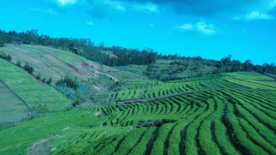
Figure 3. Bench terrace for soil and water conservation at Gumer District Jemboro Kebele.
Landslides are a concern related to landforms, and the Zone's highland regions have seen a number of tragic incidents. The main causes of landslides during the rainy season are stream erosion, rainfall-induced verge movement, and/or human disturbance. Zebidar Mountains and steep terrain are common places for landslides.
3.2. Topography
The findings of the survey, personal observations, and secondary data indicate that the Gurage zone included every kind of landform. In the highland areas of Gumer, Ezha, Gedebano Gutazer Welene, Cheha, Muhr Aklil, Geta and Endegagn districts; the dominant land forms are mountains and hills. Whereas; in the Meskan, Sodo, South Sodo, Mareko, East Meskan, Enemor, Kebena and Abeshge districts, the dominant land form is relatively plain and these areas are familiar with cereal crop production.
The topography and land setting of the Gurage Zone consists of gorges and flat lands (Figure 4). The majority of the land is undulating and rolling topography with a slope of above 8%. Moreover, it is prone to land degradation and surface runoff that needs special care to use for agricultural purposes. The land use pattern across slopes clearly show that gentle to steep slopes lands are allocated in the mid land for cereal production and in the highland for Jefore and production of cereals. Jefore is a free green land space between two oppositely set settlements with a function of all social gatherings, grazing, children’s playground and other functions (Figure 4). Plateau topography is preferred for “Jefore” and house construction while steep slopes for homestead farms, this type of land use along slopes is unusual in most parts of the world. As a result, agriculture practice in steep slope require appropriate alpine agriculture technologies and recommendations. Since the community has been accustomed to this land use pattern for a long time, it may seem impossible to change, but it will take a lot of work to shift the community's mindset in order to stop the escalating land degradation.
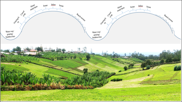
Figure 4. In the highland of Gurage Zone commonly practiced land use along slope.
Most of Gurage highland areas are inconvenient for modern agriculture because modern agriculture uses mechanized farming machines, larger areas and relatively plain fields that allows for lower operating costs. In contrast to the highland areas, lowlands of eastern districts like Meskan, East Meskan, Mareko, Sodo and South Sodo and from western districts like Abeshge, Kebena, parts of Cheha, Enemor and Ezha have gentle and a larger area for mechanization. However, the dominant soil type in Abeshge, Kebena, parts of Cheha, Enemor and Ezha districts is vertisol which is very difficult to plow when gets wet or over-dry.
Figure 5 illustrates the very steep (20-35%) and extreme (>35%) slope gradients in Gurage Zone that are dominantly found along with Zebidar Mountain in the districts of Gedebano Gutazer Welene, Ezha, Muhr Aklil and Gumer districts and along Gibe Valley at Abeshge, Cheha, and Enemor districts. Since the terrain in these districts is unsuitable for mechanized farming, local hand tools are typically used for the majority of farming operations. Generally mountainous areas of Gurage are characterized by steep slopes, rugged topography, shallow soils and cool temperatures with dominantly growing crops of enset, potato, fababean, barley, Kale (Gurage cabbage) and livestock rearing. Encouraging smallholder farmers and managing natural resources are essential to the Gurage zone's resilience and means of subsistence in these places.
Table 2. UNEP/FAO approach slope class.

Class

Slope (%)

Slope gradient class

1

0-3

Flat to gentle

2

3-12

Moderate

3

12-20

Steep

4

20-35

Very steep

5

>35

Extreme

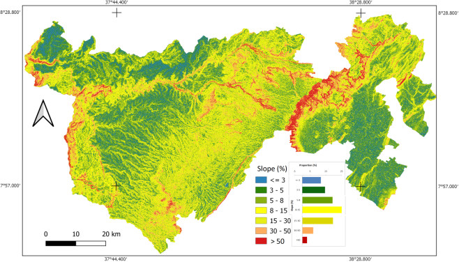
Figure 5. Slope map of Gurage Zone.
3.3. Cultural Land Scape
Jefore roads are multifunctional roads that have been designed and managed by local people for centuries . The Gurage are people in Ethiopia that formed village settlements based on the ecological conditions linked to Jefore roads and Enset culture . Jefore is a multipurpose landscape that the community uses mainly for recreational, cultural and social events for gatherings, holidays and animal grazing land. Jefore is a distinct feature and value that Gurage people practicing. However, the discussants of the survey pointed out that the heritage is in danger due to mishandlings. The survey team also observed that the land feature is currently under risk because of poor land management, road construction and expansion of land area by the nearby land owners. Because of the mismanagement, Jefore has been threatened with its cultural, social and recreational values. There is a need to recognize the importance of traditional landscapes, and to mainstream policy and decision-making regarding sustainable management before these landscapes disappear completely. Jefore is used not only as a cultural land, but also important as agricultural land in the Gurage where is used as grazing land for livestock production. It is currently suffering from unnecessary damage and facing problems that diminish its previous role, so it should be given important attention by the communities and concerned bodies.
Figure 6. Cultural land scape (Jefore) Ezha districts.
3.4. Vegetation Coverage
According to Gurage Zone Agriculture Department , the total land area of the Zone is estimated to be 637,314 ha, of which about 73.94% is cultivated. The area under natural forest is 22,296.5 ha whereas planted forest accounts for 36,332 ha largely composed of the eucalyptus tree which is an important cash source of income for the farmers. Grazing land accounts for 26,196 ha. Currently, about 35,699 ha of land in Gurage Zone is not utilized for any purpose out of which 27,711 ha is potentially usable in the future (Table 3). Enset and eucalyptus are very important crops in Gurage zone in terms of their area coverage and uses.
Table 3. Land resources of the Gurage Zone, 2008/09.

Land use type

Area coverage (ha)

Annual crops coverage

224,406.26

Perennial crops coverage

246,817.06

Cultivated total

471,223.32

Grass land

26,196.25

Natural forest

22,296.50

Community forest

2,217.96

Government owned

2,733.00

Private owned

31,381.50

Forest total

58,628.96

Riverine land

3,528.20

Cultivable but not cultivated

29,711.02

Waste land

5,987.72

Others

42,038.80

Total Area

637,314.27

Source: Gurage Zone Agriculture Department, 2019
Gurage Zone forest cover is about 9.35% of the total land with variation among districts (as low as 0.9% at Geta and as high as 14.6% at Abeshge district). Majority of the forest land is owned by private owners. Currently, Eucalyptus globulus is being planted as a reforestation program in gullies, along river banks, on private and communal lands.
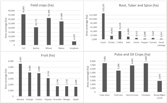
Figure 7. Gurage zone crop production area coverage (GZAD, 2019).
The Dominant trees in the Zone include eucalyptus, Acacia trees, Tsid (Juniporus procera), Kerka (Arundinaria alpina), Zigba (Podocarpus falcatus), Koso (Hagenia abyssinica). Most parts of the zone’s natural vegetation area are highly degraded but there are remnant trees (Juniperus procera, Podocarpus gracilior) observed in the lower parts of the catchment whereas Erica arborea are dominantly occurring on higher altitudes of the catchment.
3.5. Eucalyptus
The farmers who participated in the focal group discussions during the survey pointed out that eucalyptus is widely cultivated. Nearly all farmers now a day purposively grow eucalyptus. A question was raised about the destructive effects of eucalyptus planting, and most of the farmers responded that it is harmless and they consider it beneficial. Eucalyptus planted nearby farm land decrease yield, then timely the farmland also shifted to eucalyptus. Most farmers planting eucalyptus for income source and construction material. A similar survey report showed that eucalypt tree farming has become the dominant activity next to growing Enset (Ensete ventricosum (Welw.) in the Gurage Zone . A survey report from Ezha district showed that the area under eucalyptus increased and planted in the form of homesteads, farm woodlots, roadside plantations, degraded area plantations, riverside woodlots, gully side plantations and farm boundary plantations as first priority tree species . Despite all arguments raised during group discussions, the importance versus disadvantage of expansion of the eucalyptus tree in the Gurage zone still remained a paradox. As a result, based on available facts clear modality should be required to address the issues raised associated with the eucalyptus tree. Farmers grow eucalyptus on low fertile soil and poor management. Similar result reported by eucalyptus species are tolerant to severe periodic moisture stress, low soil fertility, and fire and insect damage. Even though the expansion of eucalyptus tree is threatening the production and productivity of other important crop in the zone, still there is no considered regulation to control its effect.
3.6. Enset
Enset is a perennial crop of great significance to the Gurage community and is grown by all farmers except for the unfavorable soil type and climate. The assessment clearly depicts that currently enset production is decreasing due to disease (bacterial wilt and fungus), shortage of cow dung because of decreasing livestock number, land shortage, lack of processing machines, attack due to wild animals particularly by hedgehog, expansion of eucalyptus tree are collective reasons raised during the discussion. According to yearly documented data of , from the total 471,223 hectares of overall cultivated land in Gurage Zone, enset alone covers about 129,233 hectares which is 29.9% of the total crop area coverage. Enset is produced as a homestead crop that gave the crop a better advantage to keep the enset area to be rich in organic matter because of easy access to home wastes. This result is in line with which confirms better fertility status of the enset farm compared with the cereal and grazing land because of the management practices. Enset is always combined with potato, barley, Ethiopian kale, faba bean, and in the midland with chat, coffee, and fruits.
The survey team noticed that enset is the neglected crop by the government, research institutes and all other stakeholders. Despite the presence of abiotic and biotic and institutional problems associated with enset production, the enset community maintained enset culture without introduction of improved production technologies to the system and still the crop is a pillar to sustain the livelihood of the community. Although there are limited research works on Enset, more research and development works are expected from the relevant bodies to alleviate problems on production and processing of enset. In alleviating critical enset production and processing problems, higher learning institutions and research centers should take the initiative to support the livelihood of enset-based farming communities.
4. Conclusion and Recommendation
The current poor land and vegetation management jeopardizes the potential of natural resources which predisposes for food insecurity and overall affecting the life of human beings. The survey revealed that the trend of land productivity is decreasing because of land degradations caused by both anthropogenic and natural activities. Particularly in the highland districts of Gurage, inadequate soil protection measures, lack of awareness, expansion of eucalyptus trees, deforestation, free grazing and cultivating steep slopes are important issues for the sustainable use of natural resources. Sheet and rill erosion are commonly observed in farmlands, whereas gullies are common in communal lands and edges of farmlands caused by field runoff. In Sodo, Abeshege, South Sodo, Mareko and Meskan districts gully erosion a common problem particularly in the communal lands and the effect is increasing at an alarming rate. In Cheha, Gumer, Endegagn, Enemore, Gutazer Gedabano Wolene and Muhir Aklil districts, a large area is affected by gully erosion and causing great damage along with soil acidity. The topography and land setting of the Gurage Zone consists of gorges and flat lands with the majority of undulating and rolling land having a slope of above 8% that is prone to land degradation and surface runoff which needs special care to use for agricultural purposes. As the majority of the land in Gurage Zone is mountainous, the survey team proposed Mountain Agriculture for the specified environments. Mountain Agriculture requires distinct agricultural technologies and knowledge that suit the topography.
Regarding the vegetation coverage, from the total 471,223 hectares of overall cultivated land in the Gurage zone, enset alone covers about 129,233 hectares which is 29.9% of the total area. The survey also showed in an alarming rate area coverage increment of eucalyptus tree and whereas that of enset and other indigenous tree are decreasing through time. Higher learning institutions and research centers need to take the initiative to support livelihood of the communities of mountain agriculture and natural enset-based complex farming system through supply of appropriate technologies and information.
Conflicts of Interest
The authors declare no conflicts of interest.
References
[1] Badege Bishaw 2001. Deforestation and Land Degredation in the Ethiopian Highlands: A Strategy for Physical Recovery, Northeast African Studies, 8: 1, 7-26.
[2] Beck A. and McLean W. 2013. Missing Players in Environmental Governance Chapter 1. Local, Regional, and National Forest Management and Policy in Ethiopia: Forest Cover in the Gurage Zone, 1995-201. Environmental Policy Update, 1-30.
[3] Belay Zerga, Bikila Werkineh, Demel Teketay Muluneh, Woldetsadik Mesfin Sahle 2021. Land use and land cover changes driven by expansion of eucalypt plantations in the Western Gurage Watersheds, Central-south Ethiopia, Trees, Forests and People 5 1-12.
[4] Belay Zerga Seware, Bikila Warkineh, Demel Teketay and Muluneh Woldetsadik 2021. Environmental Impacts of Eucalypt Plantations in the Western Gurage Watersheds, Central-South Ethiopia. Research square 1-3.
[5] Belay Zerga and Muluneh Woldetsadik 2016. Contribution of Eucalyptus tree farming for rural livelihood in Eza Wereda, Ethiopia. PJ Palgo J. Agricult., 3(1) 111-117.
[6] Berry L (2003). Land degradation in Ethiopia: its impact and extent in Berry L, Olson J. and Campbell D (ed): Assessing the extent, cost and impact of land degradation at the national level: findings and lessons learned from seven pilot case studies. Commissioned by global mechanism with support from the World Bank.
[7] Boland, D. J., Brooker, M. I. H., Chippendale, G. M., Hall, N. Hyland, B. P. M. and Johnson, R. D. 2006 Forest trees of Australia. Melbourne, CSIRO, Australia.
[8] Borrell, J. S., Biswas, M. K., Goodwin, M., Blomme, G., Schwarzacher, T., Heslop-Harrison, P. J. S., … Wilkin, P. 2018. Enset in Ethiopia: A poorly characterised but resilient starch staple. Annals of Botany, 123, 747–766.
[9] Eswaran Avery Beck & Wyatt McLean 2013: Missing Players in Environmental Governance Chapter 1. Local, Regional, and National Forest Management and Policy in Ethiopia: Forest Cover in the Gurage Zone, 1995-201. Environmental Policy Update, 1-30.
[10] Eswaran, H., Lal, R. and Reich, P. F. 2001. Land Degradation: An Overview. Responses to Land Degradation. Proceedings of the 2nd International Conference on Land Degradation and Desertification, Khon Kaen. Oxford Press, New Delhi.
[11] Evans A. 2012. Resources, risk and resilience: scarcity and climate change in Ethiopia. Centre on International Cooperation New York University, New York.
[12] Fetta Negash. Beira Hailu, Kyallo Martina. Abush Tesfaye. Temesgen Magule. Yao Nasser 2019. Genetic diversity and population structure of enset (Ensete ventricosum Welw Cheesman) landraces of Gurage zone, Ethiopia. Genet Resour Crop Evol.
[13] Gebrehana Girmay, Awdenegest Moges; Alemayehu Muluneh. 2020 Estimation of soil loss rate using the USLE model for Agewmariayam Watershed, northern Ethiopia, Agriculture & Food Security, 9: 9, 1-12.
[14] Girma Tadese 2001. Land Degradation: A Challenge to Ethiopia, environmental management, 815-824.
[15] GSP. Global Soil Partnership Endorses Guidelines on Sustainable Soil Management. 2017. Available online:
[16] GZANRD (Gurage Zone Agriculture and Natural Resource department) 2019, Annual Report, Wolkite.
[17] GZFEDD (Gurage Zone Finance and Economy Development Department) 2019, Annual report, Wolkite.
[18] Hurni, H., Solomon, A., Amare, B., Berhanu, D., Ludi, E., Portner, B., Birru, Y. and Gete, Z. 2010. Land degradation and sustainable land management in the highlands of Ethiopia. In: Hurni, H, Wiesmann, U. (eds.), with an international group of co-editors. Global change and sustainable development: A synthesis of regional experiences from research partnerships. Georaphica Bernensia, 5: 187-201.
[19] ISRIC, L. R. Oldeman 1992. Global Extent of Soil Degradation Published in ISRIC Bi-Annual Report 1991-1992, 19-36.
[20] Jemaludin Akmel 2020. The effect of Enset management practices on soil fertility (Ensete ventricosunm): The case of Enemorna Ener wereda, Gurage zone, SNNPR. Ethiopia. Global scientific journal, 8(3): 766-788.
[21] Lakew D, Menale K, Benin S. & Pender J. (2000). Land Degradation and Strategies for Sustainable Development in the Ethiopian Highlands: Amhara Region. Socio-Economics and policy research working Paper 32. ILRI (International Livestock Research Institute), Nairobi, Kenya.
[22] MEA (Millennium Ecosystem Assessment), 2005. Ecosystems and Human Well-being: Synthesis. Island Press, Washington, DC.
[23] Mesfin sahle and O. Saito 2021. Mapping and characterizing the Jefoure roads that have cultural heritage values in the Gurage socio-ecological production landscape of Ethiopia. Landscape and urban planning, 210: 1-13.
[24] Olsson, L., H. Barbosa, S. Bhadwal, A. Cowie, K. Delusca, D. Flores-Renteria, K. Hermans, E. Jobbagy, W. Kurz, D. Li, D. J. Sonwa, L. Stringer, 2019: Land Degradation. In: Climate Change and Land: an IPCC special report on climate change, desertification, land degradation, sustainable land management, food security, and greenhouse gas fluxes in terrestrial ecosystems.
[25] Shack William A. 1966 The Gurage: a people of the ensete culture, xiii, 222 pp., front., 6 plates. London, etc.: Oxford University Press for the International African Institute.
[26] Silenat B. and Fikadu K. 2018. Review on Expansion of Eucalyptus, its Economic Value and Related Environmental Issues in Ethiopia. International Journal of Research in Environmental Science, (4)3: 41-46.
[27] Szabo Josef, Lorant David and Denes Loczy 2010. Anthropogenic Geomorphology, A Guide to Man-Made Landforms, Springer, Dordrecht.
[28] Tamirie Hawando. 1997. Desertification in Ethiopian Highlands. RALA REPORT NO. 200, Norwegian Church AID, Addis Ababa, Ethiopia.
[29] Tekilil Wolde 2021. Opportunities and Challenges of Rehabilitating Degraded Land in the Case of Cheha Woreda, Gurage Zone, SNNP Region, Ethiopia. Research in Ecology 3(3): 37-43.
[30] Temesgen Gashaw, Amare Bantider and Hagos G/Silassie 2014. Land Degradation in Ethiopia: Causes, Impacts and Rehabilitation Techniques. Journal of Environment and Earth Science, 4(9): 98-104.
[31] UNEP (United Nation Environmental program) 1992. Desertification, land degradation [definitions]. Desertification Control Bulletin 21.
[32] WMO (World Meteorological Organization). 2005. Climate and land degradation.
[33] Wondwossen Gebretsadik, Zewde Weldemariam, Tesfaye Humnessa, Habtamnesh Adane 2018. Characterization of Agro forestry Practices and their Socioeconomic Role in Selected Districts of Gurage Zone, Ethiopia, International Journal of Research in Agriculture and Forestry 5(112): 30-40.
[34] Wood. 1990. NRM and Rural Development in Ethiopia. In Siegfried Pausewang, Fantu Cheru, Stefan Brune and Eshetu Chole (eds.) Ethiopia: Rural Development Options. Zed Books Ltd. London and New Jersey. PP 187-197.
[35] Zelalem Dendir and Belay Simane, 2019. Livelihood vulnerability to climate variability and change in different agroecological zones of Gurage Administrative Zone, Ethiopia, Progress in Disaster Science. 3: 1-8.
[36] Deresa, F. and Legesse, T. (2015) Cause of Land Degradation and Its Impacts on Livelihoods of the Population in Toke Kutaye Woreda, Ethiopia. International Journal of Scientific and Research Publications, 5, 2250-3153.
Cite This Article
  • APA Style

    Nekir, B., Yaekob, T., Negash, F., Bekele, T. (2024). Participatory Assessment of Agriculture Land and Vegetation Associated Issues and Possible Interventions in Gurage Zone, Ethiopia. American Journal of Agriculture and Forestry, 12(4), 271-281. https://doi.org/10.11648/j.ajaf.20241204.15

    Copy | Download

    ACS Style

    Nekir, B.; Yaekob, T.; Negash, F.; Bekele, T. Participatory Assessment of Agriculture Land and Vegetation Associated Issues and Possible Interventions in Gurage Zone, Ethiopia. Am. J. Agric. For. 2024, 12(4), 271-281. doi: 10.11648/j.ajaf.20241204.15

    Copy | Download

    AMA Style

    Nekir B, Yaekob T, Negash F, Bekele T. Participatory Assessment of Agriculture Land and Vegetation Associated Issues and Possible Interventions in Gurage Zone, Ethiopia. Am J Agric For. 2024;12(4):271-281. doi: 10.11648/j.ajaf.20241204.15

    Copy | Download

  • @article{10.11648/j.ajaf.20241204.15,
      author = {Bethel Nekir and Tesfaye Yaekob and Fetta Negash and Teshome Bekele},
      title = {Participatory Assessment of Agriculture Land and Vegetation Associated Issues and Possible Interventions in Gurage Zone, Ethiopia
    },
      journal = {American Journal of Agriculture and Forestry},
      volume = {12},
      number = {4},
      pages = {271-281},
      doi = {10.11648/j.ajaf.20241204.15},
      url = {https://doi.org/10.11648/j.ajaf.20241204.15},
      eprint = {https://article.sciencepublishinggroup.com/pdf/10.11648.j.ajaf.20241204.15},
      abstract = {Land degradation and depletion of natural forests made agriculture unsustainable and threaten communities and ecosystems as a whole. The objective of this participatory assessment was to identify researchable issues related to agricultural land and vegetation cover in Gurage zone. Accordingly, seven representative districts were selected and from each district two representative kebeles were purposively selected. Focus Group Discussion with farmers, development agents and subject matter specialists and direct observation were important primary sources of information. The survey result depicts in the Gurage zone land degradation, undulating steep slope topography, small and overwhelmed land tenure, inappropriate land use system, cultural landscape mismanagement, deforestation of indigenous trees and expansion of eucalyptus tree, and decreasing enset production are the major identified problems associated with land use and vegetation cover of the study area. In the mixed farming system, enset is produced as a homestead farm and its coverage is decreasing due to disease, lack of processing machines, and shortage of organic matter. Due to the expansion of eucalyptus and land use change, the majority of native trees are disappearing or decreasing in area coverage. Therefore, enset and eucalyptus require suitable policy attention. In the mountainous areas of Gurage; limited land availability, soil degradation, shortage of appropriate farm technologies, water scarcity, lack of knowledge for alpine agriculture and inconvenient topography for mechanized farming machines issues threaten agriculture of area. Despite the fact that there are few attempts to control land degradation; the issue still needs much attention. Appropriate agricultural technologies and knowledge suited for mountain agriculture, dense populations, enset-based farming systems, and small land tenure are important priority research focus areas for future research.
    },
     year = {2024}
    }
    

    Copy | Download

  • TY  - JOUR
    T1  - Participatory Assessment of Agriculture Land and Vegetation Associated Issues and Possible Interventions in Gurage Zone, Ethiopia
    
    AU  - Bethel Nekir
    AU  - Tesfaye Yaekob
    AU  - Fetta Negash
    AU  - Teshome Bekele
    Y1  - 2024/07/23
    PY  - 2024
    N1  - https://doi.org/10.11648/j.ajaf.20241204.15
    DO  - 10.11648/j.ajaf.20241204.15
    T2  - American Journal of Agriculture and Forestry
    JF  - American Journal of Agriculture and Forestry
    JO  - American Journal of Agriculture and Forestry
    SP  - 271
    EP  - 281
    PB  - Science Publishing Group
    SN  - 2330-8591
    UR  - https://doi.org/10.11648/j.ajaf.20241204.15
    AB  - Land degradation and depletion of natural forests made agriculture unsustainable and threaten communities and ecosystems as a whole. The objective of this participatory assessment was to identify researchable issues related to agricultural land and vegetation cover in Gurage zone. Accordingly, seven representative districts were selected and from each district two representative kebeles were purposively selected. Focus Group Discussion with farmers, development agents and subject matter specialists and direct observation were important primary sources of information. The survey result depicts in the Gurage zone land degradation, undulating steep slope topography, small and overwhelmed land tenure, inappropriate land use system, cultural landscape mismanagement, deforestation of indigenous trees and expansion of eucalyptus tree, and decreasing enset production are the major identified problems associated with land use and vegetation cover of the study area. In the mixed farming system, enset is produced as a homestead farm and its coverage is decreasing due to disease, lack of processing machines, and shortage of organic matter. Due to the expansion of eucalyptus and land use change, the majority of native trees are disappearing or decreasing in area coverage. Therefore, enset and eucalyptus require suitable policy attention. In the mountainous areas of Gurage; limited land availability, soil degradation, shortage of appropriate farm technologies, water scarcity, lack of knowledge for alpine agriculture and inconvenient topography for mechanized farming machines issues threaten agriculture of area. Despite the fact that there are few attempts to control land degradation; the issue still needs much attention. Appropriate agricultural technologies and knowledge suited for mountain agriculture, dense populations, enset-based farming systems, and small land tenure are important priority research focus areas for future research.
    
    VL  - 12
    IS  - 4
    ER  - 

    Copy | Download

Author Information
  • Soil and Water Management Research, Wolkite Agricultural Research Center, Wolkite, Ethiopia

  • Soil and Water Management Research, Wolkite Agricultural Research Center, Wolkite, Ethiopia

  • Crop Research, Wolkite Agricultural Research Center, Wolkite, Ethiopia

  • Soil and Water Management Research, Wolkite Agricultural Research Center, Wolkite, Ethiopia

  • Abstract
  • Keywords
  • Document Sections

    1. 1. Introduction
    2. 2. Materials and Methods
    3. 3. Result and Discussion
    4. 4. Conclusion and Recommendation
    Show Full Outline
  • Conflicts of Interest
  • References
  • Cite This Article
  • Author Information